|
|
Post by greysrigging on Dec 10, 2023 15:33:54 GMT -5
Australian capitals at dawn  |
|
|
|
Post by Beercules on Dec 11, 2023 0:11:34 GMT -5
|
|
|
|
Post by Beercules on Dec 11, 2023 2:31:50 GMT -5
Today's highs
Melbourne: 19C
Renmark: 41C
Coober Pedy: 19C
Oodnadatta: 22C
|
|
|
|
Post by Beercules on Dec 11, 2023 22:04:08 GMT -5
POSTED THIS IN THE WRONG THREAD BECAUSE IT IS FUCKING GAYTIME AS PER FUCK, IT IS NOW HERE IN ITS CORRECT THREAD I GUESS I GOT COCKY YESTERDAY, DIDN'T I NOW? I GUESS, I GOT FUCK KAN COCK - EYYYYY LOOK AT THE BERLIN WALL, LOOK AT IT  |
|
|
|
Post by greysrigging on Dec 11, 2023 22:30:37 GMT -5
Yet Another Soaking For South Australia ( Except Renmark ) ( source: Weatherzone )  After a run of four months with well below-average rainfall, Adelaide has had its sixth significant day of rain since the beginning of the last week of November, with 20 mm in the gauge to 9 am Tuesday, December 12. The image below is from 1:30 pm Monday local time, and it shows what meteorologists sometimes call a "thunderstorm train".  his particular train delivered over half a million lightning strikes (523,824 to be precise) as well as widespread rain totals of 10 mm or more, with a reading of more than 50 mm in at least one location. Here's a list of the recent rain days in the SA capital, and how much rain fell on each of those days. Nov 24: 22.8 mm Nov 28: 33.6 mm Nov 28 3.8 mm Dec 9: 8.2 mm Dec 10: 30.6 Dec 11: 11.8 Dec 12: 20.0 mm That's a total of 130.8 mm in Adelaide over 19 days. To put that in perspective, just 12 mm of rain was recorded in the period from October 1 to November 23. While we've been focusing on Adelaide thus far this story, the figures in the city tell a wider story of substantial rainfall that has occurred in nearby areas.  Indeed the map above shows the 7-day rainfall totals up to 9 am Monday, so while the overnight falls are not included, you can still see the December wet spell reflected, with most of SA getting a piece of the action. Not every corner of the state has seen rain in recent weeks. Large parts of the North East Pastoral and North West Pastoral forecast districts have missed out. RENMARK, in the Riverland district near the Victorian border, is just over 250 km from Adelaide, yet it has also missed most of the soaking rain, as the graph below shows – and that graph includes the 2.8 mm that fell overnight to 9 am Tuesday.  But overall, the recent South Australian rainfall has been good news for farmers and urban gardeners across much of the state. Significant rainfall exceeding a few millimetres is not expected anywhere in SA for at least the next week or so after this Tuesday. |
|
|
|
Post by cawfeefan on Dec 12, 2023 1:49:33 GMT -5
Was 32C/24C this afternoon
Nice to experience the novelty of such weather but damn, the humidity really hits you. Full on troppo conditions after the cool, sunless, drizzly weather of the last few days
|
|
|
|
Post by AJ1013 on Dec 12, 2023 10:38:45 GMT -5
A wet, windy, and wild week upcoming here in South Florida. Fairly stable temps during the week with increasing wind and rain as a very tight pressure gradient builds between a high over the Carolinas and a developing low in the gulf. That low then depends rapidly over Florida and Southern Georgia. Current modeling suggests winds sustained between 30mph and 40mph with rainfall between 6" and 8" (150mm-200mm). With the combination of extreme rainfall, high winds, and long duration (Wednesday through Monday) this may be the most significant winter storm to impact the region in many years. Temps:  Precip:  Winds (Thursday evening)  Conus map:  |
|
|
|
Post by greysrigging on Dec 12, 2023 15:24:41 GMT -5
Storm radar in various parts of Australia this morning Melbourne and Victoria after yesterdays 'tropical' humidity and dp's:  Victoria and Tasmania both forecast to have severe storms today:  TC Jasper lying just off the far north QLD coast:  Top End and Darwin this morning:  |
|
|
|
Post by rozenn on Dec 13, 2023 1:32:35 GMT -5
Pressure rise expected next few days  |
|
|
|
Post by Marcelo on Dec 13, 2023 9:40:18 GMT -5
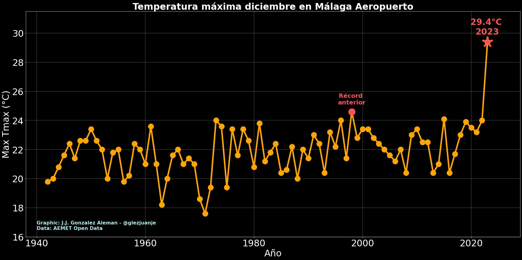
Málaga Observatory: 29.9C -> highest official temperature for December ever recorded in Peninsular Spain.
Málaga Airport: 29.4°C -> crazy record compared to the station's history. Quite a few stations from secondary networks surpassed 30C. Arboledas, Almería, reached 31.2C but the reading seems faulty to me. Various stations in Murcia that got in the 30.0-30.4C range look realistic.  |
|
|
|
Post by desiccatedi85 on Dec 13, 2023 13:45:28 GMT -5
Marcelo impressive and seems legit considering the airport had a very similar reading. Beating a record high by about 10ºF, just wow.
|
|
|
|
Post by greysrigging on Dec 13, 2023 18:43:24 GMT -5
Heatwave warnings Australia ( and Top end ) the next 3 days.   |
|
|
|
Post by Ethereal on Dec 13, 2023 23:24:13 GMT -5
Is Sydney Airport the new Penrith? Lately, it has been recording higher maximums during heat outbursts.  |
|
|
|
Post by psychedamike24 on Dec 14, 2023 1:51:01 GMT -5
 Cold snap in Manchuria + dry season heat wave in Hainan on 2023.12.11 source |
|
|
|
Post by psychedamike24 on Dec 14, 2023 2:05:58 GMT -5
The cool change after the heatwave in Outback South Austraia  Those Dec 8 to Dec 9 numbers make zero sense unless they're interpreted as "daytime high" and "nighttime low" numbers, where the temperature keeps dropping overnight as it continues raining. If anyone ever needed proof of the bi polar nature of down south weather patterns, well here it is ! Max temps up to 20c ( and more ! ) below the Dec means throughout outback South Australa....AND after 4 or 5 consecutive days of 45c heat....unreal !! Even The Alice is suffering a cold summer day ( and remember Alice Springs is only a few klm south of the Tropic of Capricorn. Be interesting to see if any Dec cold records are broken.... mind you there is aways to go yet re records, ie the dreaded 9.00am reset. And The Alice ( almost in the Tropics )   I generally don't know which of these two stats is more mind-blowing. |
|
|
|
Post by greysrigging on Dec 14, 2023 5:34:18 GMT -5
Sydney's hottest first fortnight of summer on record ( source: Weatherzone )  If you think Sydney just had an unusually hot start to summer, you weren’t imagining it. The city just experienced its hottest first fortnight of summer in more than 160 years of records. Thursday was a sweaty day across the Sydney Basin, with temperatures reaching 38.9ºC in the city and 40.3ºC at the airport by 4pm. This hot weather was exacerbated by high dew point temperatures, which made conditions feel muggy during some parts of the day.  Thursday’s heat capped off a very warm fortnight in Sydney, with the city climbing above 26ºC every day during the last two weeks and reaching around 40ºC twice. As the ABC’s Tom Saunders pointed out, this has been Sydney’s hottest start to summer on record. Sydney’s average maximum temperature during the first 14 days of summer was 29.5ºC, which beats the previous record of 28.9ºC from the first fortnight of summer in 1976. Data at Sydney’s Observatory Hill dates back to 1859. Sydney’s record hot start to summer was caused by a stagnant area of high pressure over eastern Australia, which allowed hot air to linger across NSW. A pool of abnormally warm water in the western Tasman Sea also helped limit cooling in the coastal city over the past fortnight. Unfortunately for Sydneysiders that are sick of being sweaty, daytime maximum temperatures are forecast to reach 27 to 33ºC from this Friday and at least the middle of next week. |
|
|
|
Post by Speagles84 on Dec 14, 2023 6:34:09 GMT -5
Chilly start to the day, warming up above average once again this afternoon
|
|
|
|
Post by Steelernation on Dec 14, 2023 18:21:09 GMT -5
Odd weather pattern here—three straight days of overcast and tiny diurnals like you’d get in Rochester.
Temps last 3 days:
36/29
36/29
36/30 so far
Very rare to have such a stretch here, especially without precipitation. Annoying, dead zone temps but I like the overcast. 10 f warmer and it would be perfect.
|
|
|
|
Post by srfoskey on Dec 14, 2023 20:15:18 GMT -5
White Christmas odds aren't looking too great across most of the country.  |
|
|
|
Post by greysrigging on Dec 15, 2023 0:53:43 GMT -5
Today's extremes ( so far ) in AU.  An inland site in Far North QLD in the path of ex TC Jasper the last 2 days   |
|