Deleted
Deleted Member
Posts: 0
|
Post by Deleted on Mar 25, 2019 23:36:20 GMT -5
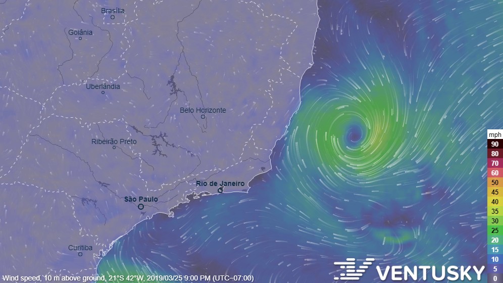
A rare tropical storm in the South Atlantic off the coast of Brazil: weather.com/storms/hurricane/news/2019-03-23-south-atlantic-tropical-storm-brazilTropical Storm Iba formed off the coast of Brazil. The last tropical storm in the South Atlantic was Anita in 2010, although several subtropical storms occurred since then. The article discussed some new findings of South Atlantic storms. Until recently, it was often believed that fully tropical storms could not form in the South Atlantic due to strong wind shear. Research shows that about one subtropical cyclone occurs every year on average in the South Atlantic while tropical storms/cyclones are less common. en.wikipedia.org/wiki/South_Atlantic_tropical_cyclone#Tropical_Storm_IbaA look at wind speeds on Ventusky:  |
|
Deleted
Deleted Member
Posts: 0
|
Post by Deleted on Mar 26, 2019 23:44:18 GMT -5
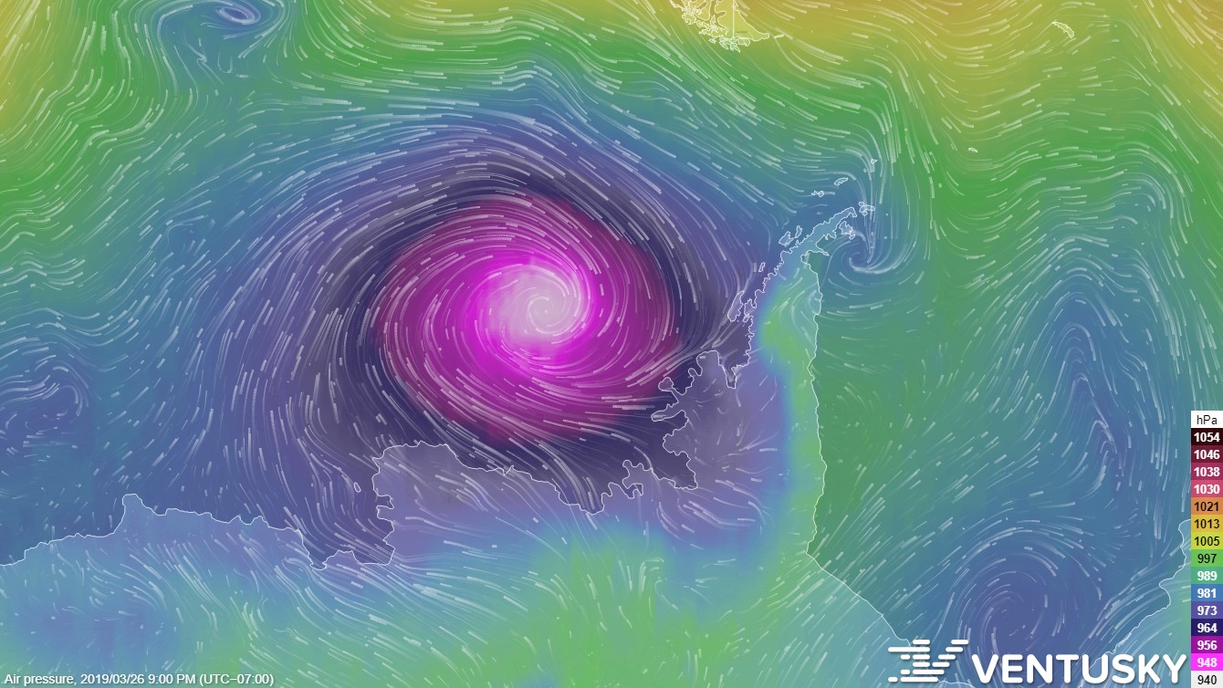
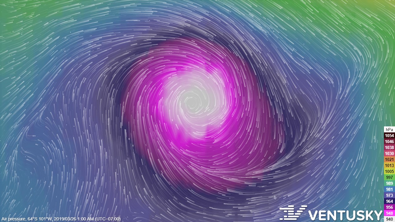
I like to just look for the lowest pressure I could find on Ventusky. Today there's something fairly unusual: An Antarctic cold-core low got down to 943 hPa/943 mb. The Braer Storm of January 1993 was the strongest extratropical cyclone I have found at 914 mb, although it is likely that there could have been stronger storms in the Antarctic not recorded before.  Also, it has gotten down to 938 mb at its peak (March 26 at 1am here, 4am in NYC, 8am in London, etc.):  |
|
|
|
Post by knot on Mar 28, 2019 10:49:53 GMT -5
www.bom.gov.au/nsw/forecasts/snowy.shtmlSnowfall above 1,100 m AMSL confirmed for my regional, this Saturday, on the 30th of March; I'm at 1,300 m AMSL, so it should be well and truly guaranteed for me. 
|
|
|
|
Post by nei on Mar 28, 2019 14:48:51 GMT -5
wet down in New Zealand
|
|
|
|
Post by Ariete on Mar 28, 2019 15:18:18 GMT -5
Arhentina maded neve.
DON'T SNOW FOR ME ARGENTIIIIIINAAAAAAAAAAAAAAAAAAAAAAA / THE TRUTH IS I NEVER LEFT YOU... I KEPT MY PROMISE / DON'T KEEP YOUR SNOWPAAAAAAACK
|
|
|
|
Post by knot on Mar 28, 2019 15:22:23 GMT -5
|
|
|
|
Post by jgtheone on Mar 31, 2019 6:09:25 GMT -5
|
|
|
|
Post by jgtheone on Apr 1, 2019 9:10:51 GMT -5
the V O I D  |
|
|
|
Post by Lommaren on Apr 1, 2019 16:05:49 GMT -5
knot, thoughts on Australia at 3 pm (I think) Sydney time on Monday?  Looks rather cold to me! Has it stayed frigid throughout after the mega January heatwave ended?
|
|
|
|
Post by knot on Apr 1, 2019 16:10:20 GMT -5
knot , thoughts on Australia at 3 pm (I think) Sydney time on Monday? Looks rather cold to me! Has it stayed frigid throughout after the mega January heatwave ended? What makes it look so cold? It is shaded with yellow. And yes: ever since the January heatwave had ceased to exist, it has straddled around or below average, with March snowfall and lower single digit maximums (barely above 5° C) upon the 30th-31st of March. I'd wager the coming months to yield below-average temperatures; above-average precipitation. Very likely. |
|
|
|
Post by Lommaren on Apr 1, 2019 16:18:04 GMT -5
What makes it look so cold? It is shaded with yellow. It means it's below 20°C at the turn of the hour in question. |
|
|
|
Post by Moron on Apr 5, 2019 11:13:54 GMT -5
Updated at 11:20 5/4/19 WA time.   BOM and GFS both show the tropical low developing into a category 3 cyclone but at the moment show it sitting off the Pilbara coast not affecting many towns except for communities in the northern kimberley tomorrow. Let's hope it gives a bit of rain but isn't strong if it crosses the coastline. |
|
|
|
Post by Moron on Apr 27, 2019 3:09:52 GMT -5
Forecast for Western Australia: Reference:  In the north of the state high pressure will bringing dry conditions today before a weak trough brings isolated showers and storms on monday and tuesday afternoon before contracting eastwards as the trough strengthens over the North-East Pilbara down to south-australia. After the unstable period, conditions will be hot and sunny with maximums in the mid 30s in the western/central Kimberley and eastern Pilbara, while rising to the high 30s in the central Pilbara and northern Kimberley around Wyndham (one of the hottest towns in australia annually). Minima will range from the low-mid 20s in the northern Kimberley with a 26C low predicted at Broome on the 1st of May (!!!!!) with minima in the low 20s to high teens throughout the Pilbara. Winds throughout the week will light or south-easterly most of the time. In the Gascoyne and Central-West the dry cold front on Monday will bring slightly cooler temps but not too much of a change, just southerly winds and possibly more cloud. These changes will be more pronounced in the southern and eastern areas of these districts. Sunny to mostly sunny forecast for the rest of the week with max/min in the low-mid 30s/mid-high teens in the northern area gradually dropping to mid-high 20s/low-mid teens. Further east in the Goldfields and Eucla region temperatures will be in the mid-high 20s before the cold front pushes through drastically dropping temperatures into the high teens with cloudy skies by wednesday and thursday (mainly in the southern Goldfields and Eucla). Afterwards temps will return to around average with sunny skies. Winds easterly on sunday becoming light westerly on monday before the front comes through bringing S/SW 20-30 then S/SE 10-30km/h later in the week. For the South-West Land Division: A warm and sunny sunday becoming cold, windy with showers clearing by wednesday morning near the coast and tuesday elsewhere. This front will mainly be dry with just wind and cloud bringing quite Maylike weather in the central/northern areas (e.g. Perth, Northam, Merredin) but close to wintry conditions on Monday and even Tuesday further south. Maximums in the high 20s sunday before the quick drop on Monday before mid teens to low 20s for early-mid week. There will be a slow and eventual rebound with high pressure over the Goldfields bringing milder easterly winds as the week progresses. I will add district centre forecasts later when they update  |
|
|
|
Post by jgtheone on Apr 29, 2019 5:07:00 GMT -5
My summary is a little bit shorter. Driest January to April period in 164 years of records. The previous record was 49.1mm from Jan-Apr in 1923, whereas this year we've recorded 49.0mm, so it's a close one.
|
|
|
|
Post by jgtheone on Apr 30, 2019 9:17:57 GMT -5
Shame about the rain shadow, but still very decent totals forecast.  |
|
|
|
Post by Moron on Apr 30, 2019 10:33:14 GMT -5
Forecast for Western Australia, April 30th: Reference:  Starting in the far north! A trough sitting roughly above Broome slowly weakens throughout the week into saturday with scattered showers and storms in the eastern and northern Kimberley over thursday, friday and clearing over saturday. The cold front hitting the SW-corner of the state will actually affect these far northern regions with skies clearing over the weekend (high pressure) followed by the first "cool" days with Halls Creek forecast 32/14 next tuesday and 36/19 in Fitzroy Crossing. These changes are pronounced near the coast or any further north than those two towns. For the week ahead skies will be partly cloudy/sunny near the coast and south clearing to sunny by the weekend all over the Kimberley. Temperatures will sit in the mid-high 30s at daytime and low-mid 20s dropping to high teens-twenty early next week. Winds generally E/SE 10-20km/h. Above average temperature for early May! In the Pilbara a trough will develop on thursday but dissipate quickly in favour of high pressure before the cold front comes through bringing weak troughs ahead of it. In general it will be a hot and sunny week for the Pilbara with maximums in the mid 30s almost every except at higher altitudes and to the far south where they'll sit in the low 30s. Minimums will drop into the teens for most towns by friday except for the Karratha region which will continue its run of very balmy 22-23C May nights  Winds will be E/SE 10-25km/h throughout the week getting stronger SE 20-30km/h around tuesday with the arrival of cool, dry air from the front. The Gascoyne and Central West will end the week with gradually warming days but nights are staying fairly cool, a sign of the approaching winter! High pressure will dominate until Sunday with the arrival of the front. Maximums will be in the high 20s/low 30s over the northern gascoyne (even 33-36C in the far north but no one lives there) with a steady decline to very low 20s around Moora and the northern wheatbelt districts east of Geraldton. By friday temperatures will be in the low 30s all over but the front will bring much cooler maximums in the low 20s in the Central West and low-mid 20s in the Gascoyne. Winds will prevail E/NE 10-20km/h becoming SE 20-30km/h early next week. The Goldfields and Eucla are still feeling the effects of the last cold front with Wednesday and Thursday being cold with maximums in the mid to high teens and minimums in the single digits. Synoptically pressure will rise and conditions will be very calm and dry providing the increase of temperatures on friday, saturday and a peak on sunday (low 30s/low teens forecast) before the front brings with it blustery westerlies, showers and cloud. Light winds dominate until friday with the arrival of warm northerlies which will intesify over saturday and sunday morning before the cool change on monday! For the South West Land Division: The next two days will be very wintry with areas close to the coast (South-West and South-Coastal districts) being much cloudier, windier and colder than Perth, the central wheatbelt (which will be very sunny and calm) and southern wheatbelt. A previously mentioned trend will also appear in the SW Land Division with a rapid warmup on friday with maximums in the high 20s in the north and low-mid 20s in the centre and south. The front will hit on Saturday bringing rain to the far SW coast and showers for the rest of the region but temperatures won't drop too much until Monday as cold air pools behind the front. Kimberley:  Pilbara:  Gascoyne:  Goldfields:  SW Land Division: (South Coastal):  (South West):  (Wheatbelt):  Perth:  |
|
|
|
Post by jgtheone on May 5, 2019 7:17:02 GMT -5
Looking menacing.  |
|
|
|
Post by jgtheone on May 13, 2019 10:40:03 GMT -5
Very warm outlook!  |
|
|
|
Post by Moron on May 16, 2019 8:03:45 GMT -5
Synoptic Forecast for the next 4 days: May 17-18: A pool of cold, high pressure will move across Western Australia bringing clear days, cold nights and southerly winds with showers clearing in the east of the state late on the 18th. The front will continue to push eastwards bringing south westerly winds to the Nullabor plain and into south australia as the weekend begins. In the Northern Territory and far north QLD showers and scattered storms from the tropical low will sit around but falls will be light. Showers from the cold front could extend far up into the northern territory. A ridge of high pressure over the NSW coast will keep the bulk of the SE mild or warm and sunny. Northerly winds will flow into Victoria and Hobart providing lasting autumnal warmth.  May 19th-20th The high pressure system in WA will gradually move east sweeping warmer temps into the SW corner of western australia with average temperatures on sunday. A second cold front will clip the state with light falls, wind and cloud. The 1st cold front will keep pushing through the populated area of south australia on saturday and victoria by sunday; falls will be light by the time it reaches Victoria. Showers will contract coastwards in the northern states. The blocking high to the east will be pushed eastwards over saturday with the high pressure over WA on friday moving to central australia.  |
|
|
|
Post by knot on May 27, 2019 0:30:12 GMT -5
Just look at how southerly that fetch is; straight from Antarctica! Arriving on Thursday, but even today I didn't manage above –0° C, with –1° C throughout the majority of the day—I can only imagine how cold Thursday might turn out.  |
|