|
|
Post by omegaraptor on May 24, 2020 17:20:49 GMT -5
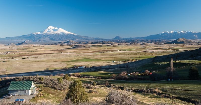
 en.wikipedia.org/wiki/Montague en.wikipedia.org/wiki/Montague,_California#Climate Located about 16 miles south of the Oregon-California border, Montague is the driest climate west of the Cascades (at least that I know of - but I'd be surprised if anything drier existed). It is several inches drier than Sequim and the Rogue Valley. It is located in the rainshadow of the Klamath Mountains, giving it a climate and vegetation type that resembles areas east of the Cascades. Note that consistent and high quality data has only been taken since mid-2000. Snow data was not available on NWS, but Yreka gets 12.5" per year (variable amount) so it can be assumed that Montague is similar. The climate classifies as Csa per Koppen, but if you add precipitation in the summer, it becomes Bsk! Don't drink too much vodka when classifying climate.  |
|
|
|
Post by knot on May 24, 2020 17:37:36 GMT -5
B+; summer highs too stable, but winter temps + precip patterns are lovely. Overall too bloody dry.
|
|
|
|
Post by Steelernation on May 24, 2020 18:39:24 GMT -5
B. Temps are good but it’s too stable and the precipitation pattern is wrong.
|
|
|
|
Post by 🖕🏿Mörön🖕🏿 on May 24, 2020 19:13:26 GMT -5
 en.wikipedia.org/wiki/Montague en.wikipedia.org/wiki/Montague,_California#Climate Located about 16 miles south of the Oregon-California border, Montague is the driest climate west of the Cascades (at least that I know of - but I'd be surprised if anything drier existed). It is several inches drier than Sequim and the Rogue Valley. It is located in the rainshadow of the Klamath Mountains, giving it a climate and vegetation type that resembles areas east of the Cascades. Note that consistent and high quality data has only been taken since mid-2000. Snow data was not available on NWS, but Yreka gets 12.5" per year (variable amount) so it can be assumed that Montague is similar. The climate classifies as Csa per Koppen, but if you add precipitation in the summer, it becomes Bsk! Don't drink too much vodka when classifying climate.  You sure SMHI isn't taking these measurements? Period of record looks mighty suspect...  Anyway, I'll give the climate a D+ and the scenery a B+. Precipitation pattern is boring and the climate is overall much too prone to warmth, rather than cold. |
|
|
|
Post by omegaraptor on May 24, 2020 19:26:12 GMT -5
 en.wikipedia.org/wiki/Montague en.wikipedia.org/wiki/Montague,_California#Climate Located about 16 miles south of the Oregon-California border, Montague is the driest climate west of the Cascades (at least that I know of - but I'd be surprised if anything drier existed). It is several inches drier than Sequim and the Rogue Valley. It is located in the rainshadow of the Klamath Mountains, giving it a climate and vegetation type that resembles areas east of the Cascades. Note that consistent and high quality data has only been taken since mid-2000. Snow data was not available on NWS, but Yreka gets 12.5" per year (variable amount) so it can be assumed that Montague is similar. The climate classifies as Csa per Koppen, but if you add precipitation in the summer, it becomes Bsk! Don't drink too much vodka when classifying climate.  You sure SMHI isn't taking these measurements? Period of record looks mighty suspect...  Anyway, I'll give the climate a D+ and the scenery a B+. Precipitation pattern is boring and the climate is overall much too prone to warmth, rather than cold. KSIY is an official ICAO station. NWS Medford even uses it as one of their official stations for the observed weather reports. |
|
|
|
Post by Speagles84 on May 26, 2020 9:48:23 GMT -5
E+ = No snow, too dry, too warm in winter, hot as shit in summer. Pretty awful IMO
|
|
|
|
Post by Benfxmth on May 26, 2020 10:07:51 GMT -5
B+; too cold in winter and at night in summer but with nice afternoons.
|
|
|
|
Post by jgtheone on May 27, 2020 7:30:27 GMT -5
B-, too dry and minimums are too low but high temps are perfect and I'm sure the sun hours are too.
Yreka is 10km west of here and is 200mm wetter, why? Elevations are similar.
|
|
|
|
Post by omegaraptor on May 27, 2020 13:30:43 GMT -5
B-, too dry and minimums are too low but high temps are perfect and I'm sure the sun hours are too. Yreka is 10km west of here and is 200mm wetter, why? Elevations are similar. Yreka is right up against the mountains and on the edge of the rainshadow. Montague is in the driest part of the rainshadow, the north-central part. |
|
|
|
Post by rpvan on May 27, 2020 17:37:53 GMT -5
C.
April thru September looks lovely. The other half of the year on the other hand...too warm (especially daytime highs) and dry.
|
|
|
|
Post by Crunch41 on May 28, 2020 11:09:10 GMT -5
D+, too dry and warm
|
|