|
|
Post by chesternz on Dec 20, 2020 10:51:47 GMT -5
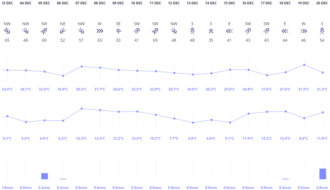
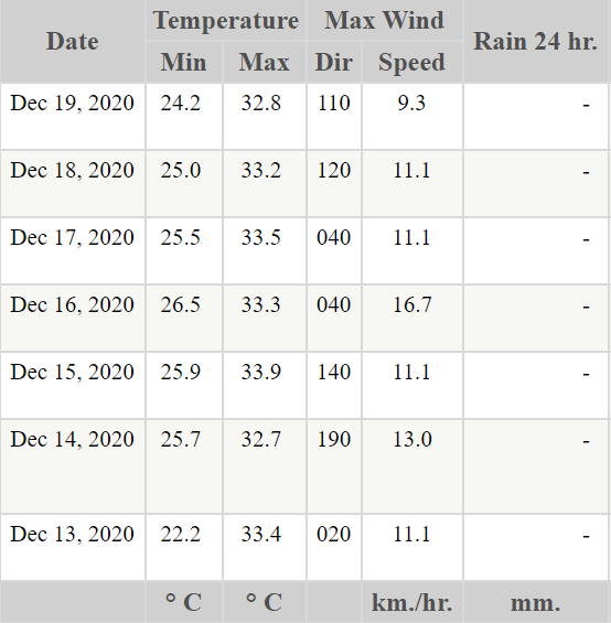
Christchurch had a high of 31.5 C a couple of days ago. But look at all those 5-6 C lows in what is supposed to be summer! Glad I moved.  Meanwhile in BKK, it's been a weird week with unseasonably hot and humid weather earlier in the week (dewpoints over 26 C) before settling down to more typical conditions for the weekend (dewpoints down to 14 C and lows not much over 20 C). We even had a pretty good thunderstorm earlier in the week with several cloud-to-ground strikes, a lot of loud thunder and prolonged heavy rainfall. It must have been very localised though as no site in the city recorded even a trace amount of rain. We seldom get heavy rain (let alone thunderstorms) during the dry season, so it's always a nice surprise when we do.  |
|
|
|
Post by ilmc90 on Dec 20, 2020 12:51:56 GMT -5
Slate gray skies today. Looks bright with with the snow cover. 30 F/-1 C just before 1PM.
|
|
|
|
Post by Doña Jimena on Dec 20, 2020 15:49:47 GMT -5
Not as mild as on previous days with a low of 1.1C and a high of 4.7C in Riga. Grey, no sunshine. Next week looks similar, some degrees above freezing, grey, some rain. There is a big freeze in southern Russia, but it won't reach here.  |
|
|
|
Post by Benfxmth on Dec 20, 2020 15:59:39 GMT -5
Not as mild as on previous days with a low of 1.1C and a high of 4.7C in Riga. Grey, no sunshine. Next week looks similar, some degrees above freezing, grey, some rain. There is a big freeze in southern Russia, but it won't reach here.  Most of Europe is getting an influx of mild, maritime air from the Atlantic, while central European Russia is getting an influx of dry air from the east.  |
|
|
|
Post by knot on Dec 20, 2020 18:58:34 GMT -5
I didn't think any month in 2020 would piss me off as much as July did weather-wise. Turns out I'm wrong…nothing but perma low-twenties shit heap as far as the eye can see, with no real weather apart from a minor NW Cloudband. Fingers crossed for a classic Riverina Summer (Feb–Mar) in 2021. A rare jewel nowadays.  |
|
|
|
Post by rpvan on Dec 20, 2020 19:29:52 GMT -5
Possibility for some wet snow in the higher elevations (above 100-200m) across the Vancouver region tomorrow. Seattle and Victoria too.
|
|
|
|
Post by Benfxmth on Dec 20, 2020 20:46:12 GMT -5
|
|
|
|
Post by Beercules on Dec 20, 2020 21:22:39 GMT -5
|
|
|
|
Post by Babu on Dec 21, 2020 6:06:24 GMT -5
The last few days have been very mild in the valleys of Western Norway. This is Tafjord  |
|
|
|
Post by AJ1013 on Dec 21, 2020 6:14:36 GMT -5
Babu Woah that is unbelievable
|
|
|
|
Post by Babu on Dec 21, 2020 6:33:26 GMT -5
Babu Woah that is unbelievable It's still early in the day. They've gone up to 12.7'C now since I posted that image. Not quite up to 2015 in terms of "heatwaves" though  |
|
|
|
Post by Morningrise on Dec 21, 2020 6:50:57 GMT -5
Well these first 2/3rds of December have been super mild over here, with an average high of -3.6C (4.4C above average) and average low of -15.2C (3.1C above average). We've had more highs above freezing than below -5C which is pretty exceptional.
It's gonna cool down a bit for the remainder of the month but still be much warmer than usual, which is fantastic. If this was what typical winter weather was like here I would like this climate so much more. If only this mildness could last through January and February!
|
|
|
|
Post by nei on Dec 21, 2020 9:18:55 GMT -5
Happy solistice
|
|
|
|
Post by Nidaros on Dec 21, 2020 15:11:28 GMT -5
Yeah, finally days are getting longer! But veeeery slowly the first two weeks
|
|
|
|
Post by rozenn on Dec 21, 2020 19:03:14 GMT -5
850 hPa temps will plummet by 15°C between now and Thursday. Well they can't really get any higher this time of year.  |
|
|
|
Post by nei on Dec 21, 2020 21:05:34 GMT -5
Christmas rain could melt 3-4 feet of snow in Vermont
|
|
|
|
Post by nei on Dec 21, 2020 21:14:32 GMT -5
straight shot of tropical Atlantic moisture arriving on Christmas Eve
/
|
|
|
|
Post by Benfxmth on Dec 21, 2020 21:25:23 GMT -5
straight shot of tropical Atlantic moisture arriving on Christmas Eve / Interesting how this time I'm largely outside the path of the tropical moisture, even if NWS is forecasting ~60°F afternoon dew points here.  |
|
|
|
Post by Crunch41 on Dec 21, 2020 21:25:53 GMT -5
Very strong winds coming for much of Alaska, east of Cordova being hardest hit. Forecast for Cape St. Elias, which goes up to 450m, but this is sea level. 70-80mph winds is hurricane force.  Cordova is getting rain and wind, but there are blizzard warnings to the west and in higher elevations. Out on the water, hurricane force wind warning.  Two insane point forecasts for mountains. Uninhabited of course. Extremely windy forecast for this mountain valley at 3600' in between Seward and Homer. Must be the right shape for the wind to funnel in there.  5100' southwest of Seward 5100' southwest of Seward. The snow totals 
Lol, ben posted it before I finished editing mine. See below. About 100" of snow forecast from this storm, 2.5 meters. The hourly data for there has about 10" of precipitation which compared to 5-7" at sea level. With temperatures in the mid 20s, it's possible.
|
|
|
|
Post by Benfxmth on Dec 21, 2020 21:38:11 GMT -5
Holy fuck – credit to Crunch41 to alerting me about this forecast. I wonder how accurate it is.   |
|