|
|
Post by Benfxmth on Feb 3, 2021 8:56:25 GMT -5
Signals for wintry precipitation next week are strong according to EPS
|
|
|
|
Post by alex992 on Feb 3, 2021 10:26:07 GMT -5
Beautiful out today, 53 F (11.7 C) with a 37 F (2.8 C) dew point as of 10 am, morning low was 45 F (7.2 C) at the airport (probably about 42 F / 5.6 C where I live) and heading up to 66 F (18.9 C).
Tonight is gonna be quite chilly by our standards (predicted low is 39 F (3.9 C) per TWC, 40 F (4.4 C) per NWS), but the forecast goes to shit quite quickly after tomorrow.
|
|
|
|
Post by alex992 on Feb 3, 2021 10:41:45 GMT -5
Strong UHI / coastal influence being shown tonight due to tonight being a clear, calm night. 45 F in Ft. Lauderdale and 48 F in Miami being predicted, meanwhile 35-40 F for my area. Also, looking like frost will definitely happen inland.  |
|
|
|
Post by Wildcat on Feb 3, 2021 10:55:11 GMT -5
Botev groundhog
|
|
|
|
Post by P London on Feb 3, 2021 10:57:55 GMT -5
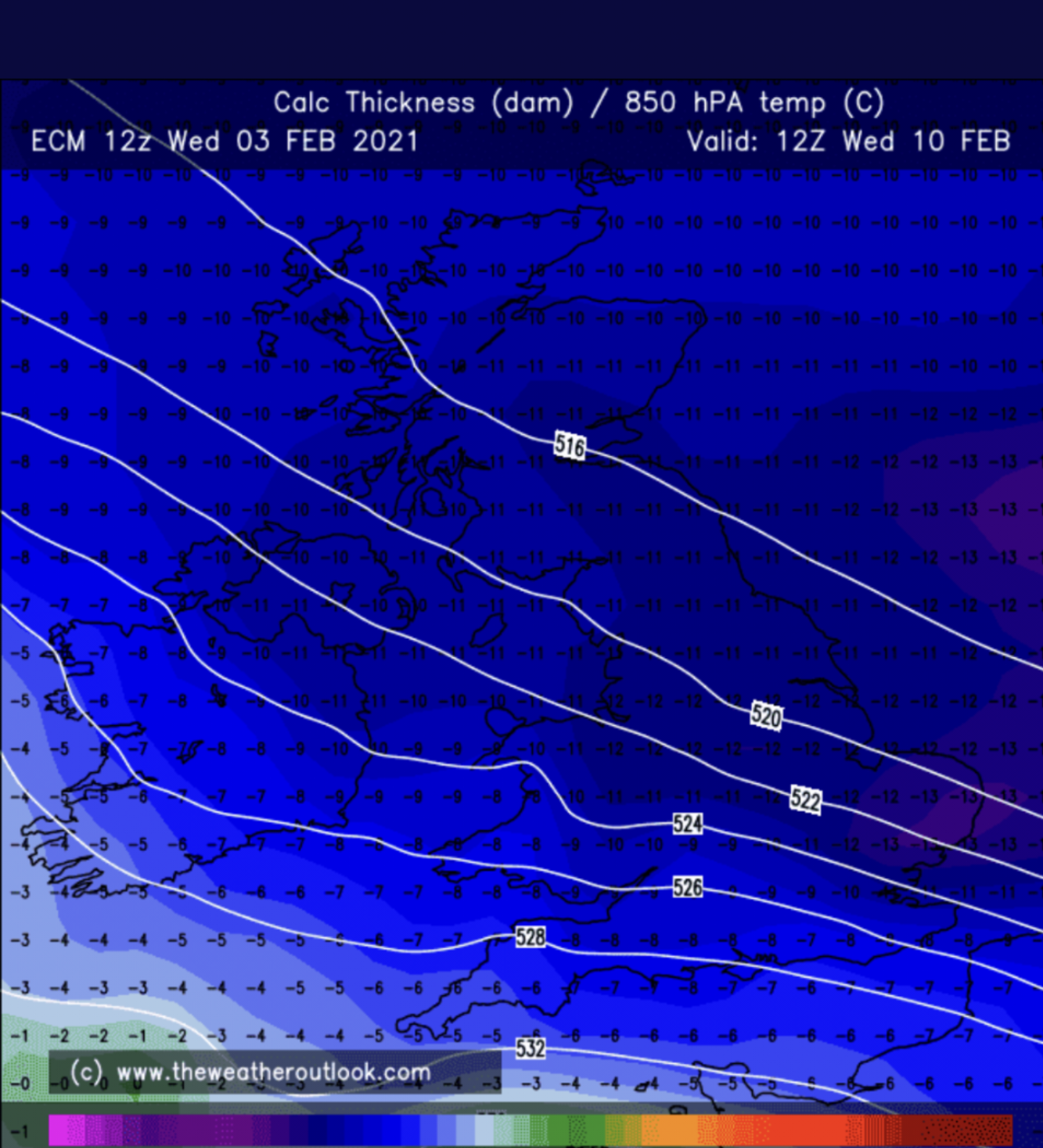
So we could be seeing the famous Beasterly next week in the UK / Western Europe. Its been a while since I've posted a computer weather model haha!   |
|
|
|
Post by Nidaros on Feb 3, 2021 14:36:23 GMT -5
Warning for risk of bushfire along the coast north of the Arctic Circle in Norway, from Bodø to Narvik. In February. twitter/meteorologeneYes, you heard that right. |
|
|
|
Post by FrozenI69 on Feb 3, 2021 17:10:47 GMT -5
Looks like the Arctic blast has been dialed back in the upper south and northeast, but it has been amplified for the Great lakes region  . |
|
|
|
Post by dunnowhattoputhere on Feb 3, 2021 17:13:35 GMT -5
Yikes.  |
|
|
|
Post by rozenn on Feb 3, 2021 17:40:37 GMT -5
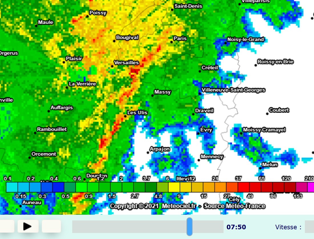
What a pathetic turn this whole mascarade took. I hope it delivers to you guys, after all you've been denied winter for at least as long as us. Meanwhile in Punta Cana Paris... Squall line today, with winds up to 110 km/h in NW suburban Pontoise and 108 km/h in SW suburban Toussus-le-Noble. EDIT: damn, 140 km/h @ the Eiffel tower (87 mph). I haven't followed gusts up there until recently but it does deliver. This is what the radar looked like this morning:  Is it somewhat interesting? Maybe. Does this shit have its place in winter? Absolutely not. |
|
|
|
Post by dunnowhattoputhere on Feb 3, 2021 17:44:56 GMT -5
You’ll make up for it in the summer when it’s 35C in Paris and 20C here.
|
|
|
|
Post by Ariete on Feb 3, 2021 17:51:09 GMT -5
Just a day away:
-15.3C and dropping in Turku.
|
|
|
|
Post by rozenn on Feb 3, 2021 17:53:01 GMT -5
You’ll make up for it in the summer when it’s 35C in Paris and 20C here. If it only reaches 35°C I will consider this summer a failure too tbh. If the climate's warming, it might as well do so in all seasons.  |
|
|
|
Post by Ariete on Feb 3, 2021 17:57:21 GMT -5
FMI forecasts a -27C low for 10 February. That would be a new record low for the Artukainen station, operational since 2003.
|
|
|
|
Post by rozenn on Feb 3, 2021 18:34:25 GMT -5
Snowmageddon in the cards for the NE Netherlands & Lower Saxony.  Sharp temperature gradient, with potentially bone-chilling midday temps over there. The North Sea moderation makes for lackluster temps in the UK as always under easterlies. The only hope for real cold there is to get a decent snowcover and get the flow to slow down. Lots of ifs if you ask me. Of course here both the 850 hPa and 2 m levels will be mild. Jealousy will prolly be through the roof at some point of the week:  The whole situation reminds me of late 1978, with its strong latitudinal temperature gradient. Nice treat then on NYE in Paris as it was 9°C with a 8°C dp around noon but -11°C with a -20 windchill at midnight, US-style.  |
|
|
|
Post by dunnowhattoputhere on Feb 3, 2021 18:48:10 GMT -5
|
|
|
|
Post by rozenn on Feb 3, 2021 18:55:20 GMT -5
GFS is allergic to showing deep snow in the UK     ECM is my best friend: Damn that'd be epic. Jealousy would be off the charts really. Look at the lenght of this easterly. It goes from the Ukraine to Newfoundland at least! It that was shifted 1000 km to the south at a few thousand km to the east man it would be epic. Note the constant or even decreasing geopotential heights heading north despite the strong sea level pressure rise. That air over Scandinavia is frigid!  |
|
|
|
Post by Benfxmth on Feb 3, 2021 20:00:26 GMT -5
This explains why the anticipated cold outbreak has been pushed back (Unlikely to verify, but still), the GFS 18Z run has over a foot of snowfall on the 13th!   |
|
|
|
Post by ral31 on Feb 3, 2021 20:57:51 GMT -5
(Unlikely to verify, but still), the GFS 18Z run has over a foot of snowfall on the 13th!  The GFS run before that one had me with close to a foot of snow the end of next week, and a low of 9F the morning of Feb 14! |
|
|
|
Post by nei on Feb 3, 2021 21:03:15 GMT -5
Trains in the snow, Manhattan
|
|
|
|
Post by Steelernation on Feb 3, 2021 23:42:18 GMT -5
High was 59 (15 c), the 6th straight 50+ high.
Weird day, hit the high a little after 11 AM with sunny skies. Then a brief cold front came in that knocked the temp down to the high 40s with clouds and high winds. However, by 1:30, the sun was back out and it was once again in the high 50s.
|
|