|
|
Post by Cadeau on Mar 15, 2022 13:36:28 GMT -5
Metropolitan Area
Latitude: 42°N
|
|
|
|
Post by Cadeau on Mar 15, 2022 13:36:46 GMT -5
Metropolitan Area
Latitude: 42°N
|
|
Deleted
Deleted Member
Posts: 0
|
Post by Deleted on Mar 15, 2022 13:48:56 GMT -5
Metropolitan Area
Latitude: 42°N How do you create that weather forecast box? |
|
|
|
Post by jgtheone on Mar 19, 2022 8:28:19 GMT -5
7 day forecast for Northlake: Fine apart from a morning storm on Wednesday. Becoming drier into the weekend.  7 day forecast for Blocktown: 7 day forecast for Blocktown: Humid and wet to start, before becoming drier for the weekend. 
|
|
|
|
Post by Steelernation on Mar 19, 2022 12:12:58 GMT -5
3/20: High 75 Low 37 🌤 Warm, mostly sunny
3/21: High 43 Low 28 🌨 Colder, snow showers
3/22: High 40 Low 26 🌨 Cloudy, snow showers late
3/23: High 41 Low 19 🌨 Morning snow showers
3/24: High 52 Low 31 ⛅️ Partly sunny
3/25: High 67 Low 34 ☀️ Sunny, milder
3/26: High 72 Low 39 ☀️ Sunny
Averages on 3/20 are 58/29 and on 3/26 they are 60/31
In C:
High 24 Low 3
High 6 Low -2
High 4 Low -3
High 5 Low -7
High 11 Low -1
High 19 Low 1
High 22 Low 4
Averages on 3/20 are 14/-2 and on 3/26 they are 16/-1
|
|
|
|
Post by desiccatedi85 on Mar 20, 2022 9:52:12 GMT -5
Second Half of March Forecast - Palomares
March 16: 67/52 🌤
March 17: 70/53 🌤
March 18: 73/54 🌤
March 19: 69/61 🌥
March 20: 71/43 ⛈ (0.55”)
March 21: 59/42 🌤
March 22: 62/45 🌤
March 23: 64/51 ⛅️
March 24: 67/53 ⛅️
March 25: 67/56 ⛅️
March 26: 68/56 ⛅️
March 27: 65/59 🌦 (0.05”)
March 28: 63/62 🌧 (1.20”)
March 29: 70/51 ⛅️
March 30: 76/57 🌤
March 31: 72/47 ⛈ (0.25”)
|
|
|
|
Post by ilmc90 on Mar 20, 2022 10:37:49 GMT -5
Mild start to the week but then seasonably chilly temperatures before getting even colder over the weekend.
Sunday, 3/20: Cloudy with periods of rain. Rainfall around a quarter inch.
High 53 F/12 C. Low 44 F/7 C.
Monday, 3/21: Cloudy most of the day but some clearing late afternoon.
High 50 F/10 C. Low 42 F/6 C.
Tuesday, 3/22: Cloudy and breezy with showers. Rain may be heavy at times.
High 44 F/7 C. Low 34 F/1 C.
Wednesday, 3/23: Light snow in the morning, otherwise mostly cloudy.
High 35 F/2 C. Low 29 F/-2 C.
Thursday, 3/24: Partly Cloudy.
High 37 F/3 C. Low 26 F/-3 C.
Friday, 3/25: Mix of sun and clouds.
High 36 F/2 C. Low 24 F/-4 C.
Saturday, 3/26: Mostly cloudy with scattered flurries.
High 31 F/-1 C. Low 23 F/-5 C.
|
|
|
|
Post by Cadeau on Mar 20, 2022 10:43:16 GMT -5
Metropolitan Area
Latitude: 42°N
|
|
|
|
Post by Cadeau on Mar 20, 2022 11:03:47 GMT -5
How do you create that weather forecast box? I manually create the box by using the table format. |
|
|
|
Post by ilmc90 on Mar 26, 2022 9:51:23 GMT -5
Seasonable to slightly below average temperatures. Plenty of snow chances for the upcoming week.
Sunday, 3/27: Mostly cloudy and windy with scattered snow showers. Snow may be heavy at times.
High 31 F/-1 C. Low 22 F/-6 C.
Monday, 3/28: Mostly Sunny.
High 36 F/2 C. Low 20 F/-7 C.
Tuesday, 3/29: Cloudy with periods of light snow. Snowfall accumulation under one inch.
High 35 F/2 C. Low 23 F/-5 C.
Wednesday, 3/30: Sunny in the morning but becoming cloudy with snow in the afternoon and evening. Snowfall accumulation 2-4 inches.
High 35 F/2 C. Low 21 F/-6 C.
Thursday, 3/31: Snow ending before dawn, otherwise mostly cloudy. Snowfall accumulation around one inch.
High 32 F/0 C. Low 28 F/-2 C.
Friday, 4/1: Mostly cloudy and windy with scattered flurries.
High 34 F/1 C. Low 25 F/-4 C.
Saturday, 4/2: Windy with snow. Snowfall accumulation 4-8 inches.
High 33 F/1 C. Low 24 F/-4 C.
|
|
|
|
Post by Steelernation on Mar 26, 2022 21:20:11 GMT -5
3/27: High 71 Low 39 🌤 Mostly sunny
3/28: High 82 Low 45 ☀️ Warm and sunny
3/29: High 74 Low 28 ⛅️ Warm, then much colder
3/30: High 44 Low 25 🌨 Colder with snow showers
3/31: High 54 Low 27 🌥 Mostly cloudy
4/01: High 50 Low 29 🌨 Chance snow late
4/02: High 54 Low 27 ⛅️ Partly cloudy
Averages on 3/27 are 60/31 and on 4/2 they are 62/32
In C:
High 22 Low 4
High 28 Low 7
High 23 Low -2
High 7 Low -4
High 12 Low -3
High 10 Low -2
High 12 Low -3
Averages on 3/27 are 16/-1 and on 4/2 they are 17/0
|
|
|
|
Post by jgtheone on Mar 27, 2022 5:43:12 GMT -5
7 day forecast for Northlake: Dry, sunny conditions to continue for the whole week. Wednesday has the potential to be the latest 100F (37.8C) on record.  7 day forecast for Blocktown: 7 day forecast for Blocktown: Warm to start, before some showers and cooler conditions on Friday and Saturday. Crisp on Sunday morning. 
|
|
|
|
Post by Cadeau on Mar 27, 2022 14:38:37 GMT -5
Metropolitan Area
Latitude: 42°N
|
|
|
|
Post by jgtheone on Mar 31, 2022 3:30:36 GMT -5
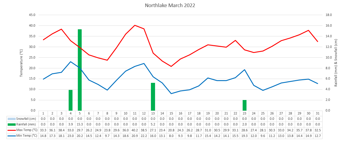
Northlake March 2022/YTD summary:Avg high: 30.7°C (+0.4°C) Avg low: 14.6°C (+0.8°C) Rainfall: 26.4mm (-8.4mm, 75.9% of avg) Snowfall: 0cm Sunshine: 305.4 hours (+9.7 hours, 103.3% of avg)  
|
|
|
|
Post by jgtheone on Mar 31, 2022 3:33:26 GMT -5
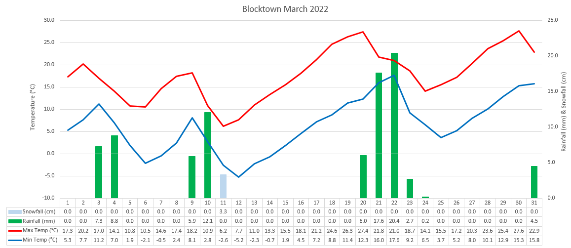
Blocktown March 2022/YTD summary:Avg high: 17.8°C (-1.2°C) Avg low: 6.4°C (-1.5°C) Rainfall: 85.5mm (+9.7mm, 112.8% of avg) Snowfall: 3.3cm (+3.2cm, 3300% of avg) Sunshine: 190.3 hours (-7.7 hours, 96.1% of avg)  
|
|
|
|
Post by ilmc90 on Mar 31, 2022 10:57:00 GMT -5
Well above average (+6 F) for the month but still wintry.  |
|
|
|
Post by Steelernation on Apr 1, 2022 12:38:18 GMT -5
March was cool and snowy: Average high: 54.2 (-1.9 f) Average low: 24.3 (-3.6 f) Mean: 39.3 (-2.7 f) Precipitation: 2.17” (+1.38”, 275%) Precip days: 8 Snowfall: 32.6” (+21.2”, 286%) Snow days: 8 Max daily snowfall: 14.3” on the 9th Max snow depth: 18” on the 10th Days snow lying: 15 Highest temp: 76 on the 2nd Lowest temp: -1 on the 11th Highest low: 39 on the 20th Lowest high: 18 on the 10th Here’s the month:  And the year:  |
|
|
|
Post by Cadeau on Apr 1, 2022 12:40:22 GMT -5
March 2022 was the 3rd warmest March in this century.
Metropolitan Area
Latitude: 42°N Temperature: +2.6°C from normal Temperature: +2.6°C from normal
Precipitation: 67% of normal
Sunshine: 126% of normal
March 2022 Summary
High/Low/Mean
15.3/6.7/11.0
Highest: 23.8°C[27th]
Lowest: -0.9°C[5th]
Lowest High: 9.8°C[4th]
Highest Low: 12.1°C[30th]
Precipitation: 42.8 mm
Precipitation Days: 9
Snowfall: 0.0 cm
Snow Days: 0
Sunshine Hours: 187.5 hours
Sunshine Percentage: 50.6%
Early February: High 11.8°C / Low 3.9°C / Mean 7.8°C / Precipitation 7.8 mm / 57.2 sunshine hours
Mid February: High 15.1°C / Low 7.6°C / Mean 11.4°C / Precipitation 26.6 mm / 48.9 sunshine hours
Late February: High 18.7°C / Low 8.5°C / Mean 13.6°C / Precipitation 8.4 mm / 81.4 sunshine hours
|
|
|
|
Post by Benfxmth on Apr 1, 2022 13:55:57 GMT -5
|
|
|
|
Post by Benfxmth on Apr 2, 2022 4:38:10 GMT -5
  .SYNOPSIS...
High pressure will over the area today, sliding offshore this
afternoon. A quick moving cold front will move through the area
late tonight, with high pressure moving back in Sunday. The next
significant weather maker will impact the region by mid week.
&&
.NEAR TERM /UNTIL 6 PM THIS EVENING/...
As of 9:00 AM Sat...A pleasant day is expected with high pressure
remaining over the area. With a dry air mass still in place,
skies will remain mostly sunny through most of the day, though
high clouds will be arriving late in advance of the next system.
Despite sunny skies below normal low level thicknesses and
onshore NE to E flow off the cool ocean will keep highs in 60s at the coast, temps will warm
further inland to the upper 60s/lower 70s.
&&
.SHORT TERM /6 PM THIS EVENING THROUGH 6 AM SUNDAY/...
As of 9:00 AM Sat...Flow will continue to veer to the SE tonight
as high pressure moves farther off. Then in response to a
weak shortwave moving into the region through the broader
cyclonic flow, a quick moving but weak cold front will cross into the
forecast area overnight and push offshore by early tomorrow
morning. Most guidance is now in agreement that enough moisture
return will occur before the arrival of this front for isolated/widely
scattered showers to develop across the eastern 2/3rds of the area early tomorrow
morning.
Temperatures will fall into the lower to mid 50s early
tonight and then likely hold steady as clouds increase and SE
flow develops. Right ahead of the front early tomorrow morning,
temps will begin to increase especially along the coast.
&&
.LONG TERM /SUNDAY THROUGH FRIDAY/...
As of 9:05 AM Sat...Seasonable and quiet to finish off the
weekend. Next significant weather maker affects the area by mid
week.
Sunday through Tuesday...Rapid clearing second half of the weekend
with a return to sunshine and high pressure. Temps again above
climo with generally upper 70s to the 80s inland, to lower-mid 70s at the coast.
Grad warming trend early next week, with temps climbing well into the 80s by Tuesday.
Overnight lows in the lower 50s.
Tuesday night through Thursday...Next potential significant system
arrives by late Tue aftn, with GFS/ECMWF/CMC in general agreement with
synoptic regime. A large, deep trough will dig into the west of the region, with
stream energy ejecting eastward through region. Rain looks to be a good bet
centered on Tuesday night, with some modest instability available. Will have to
monitor for potential severe threat as a result. Nudged POPs
up to around 50-70% Tue night, and a few rumbles of thunder are possible.
Second shot for showers and T-storms arrives Thu as amplified trough
digs across the area, pushing along a strong cold front.
Global guidance showing even greater instability compared to Wed
along with sufficient shear parameters in place. While
parameters and timing will likely change over the coming days,
the potential for severe weather will need to be monitored for any storms that
do develop. Temps above climo expected midweek.
Friday...Cut-off low will meander to the north with
secondary coastal low developing along a quasi-stationary front
lingering along the eastern seaboard, but looking dry with insufficient moisture with this one.
More seasonable, cooler temps behind the front, with highs in the upper 70s. |
|