|
|
Post by Morningrise on Jul 8, 2022 15:15:29 GMT -5
A tornado watch is officially in effect for Saskatoon! We're still in the clear at the moment but conditions are favourable for the development of severe thunderstorms in the area this afternoon and they're expected to be strong enough to potentially spawn tornadoes. Currently sitting at 29C with a 19C dew point, which is definitely the type of weather that can give us intense storms.
|
|
Deleted
Deleted Member
Posts: 0
|
Post by Deleted on Jul 8, 2022 17:00:47 GMT -5
|
|
|
|
Post by rpvan on Jul 8, 2022 17:38:48 GMT -5
Mid and long range forecast outlooks for North America:
|
|
|
|
Post by srfoskey on Jul 9, 2022 1:04:02 GMT -5
Thanks to a cold frontal passage, we should be done with highs in the 100s for the near future. However, highs will still be around 95°F (35°C), which is slightly above normal.
Metsfan would be happy to know that our grass is turning yellow because of how hot and dry it's been.
I was down in Davis today, and there was a rain shower, but the rain would evaporate not long after it hit the ground, because the temperature was close to 100°F (38°C).
|
|
|
|
Post by chesternz on Jul 9, 2022 5:15:59 GMT -5
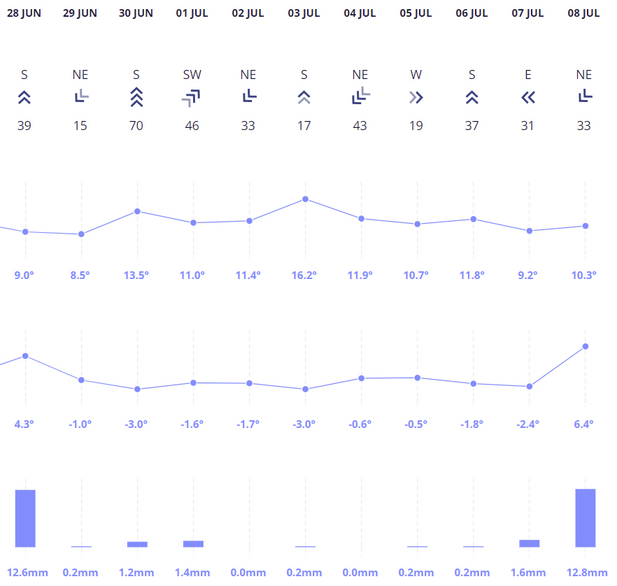
Pretty impressive nine day frost streak in ChCh:  |
|
|
|
Post by Met.Data on Jul 9, 2022 6:32:01 GMT -5
British temperature record easily smashed next weekend = 43°C / 110°F.  |
|
|
|
Post by Yahya Sinwar on Jul 9, 2022 6:35:57 GMT -5
Widespread drought relief, almost all of this fell in the last 12 hours. Almost all of eastern NC covered in 3-7 inch totals overnight. More today as well could have some areas in the 10-14 inch rainfall totals for the week. So much for being drier than the northeast metzy. Temps are current morning lows. Been hitting 90s with dews in the 76-80 degree range before the sky just pours on us.  |
|
|
|
Post by ilmc90 on Jul 9, 2022 7:12:43 GMT -5
Pleasant morning here...71 F/22 C with a dewpoint of 59 F/15 C at 8:00AM. Should be a nice weekend with dews in the 50s and highs in the low 80s.
|
|
|
|
Post by ilmc90 on Jul 9, 2022 9:55:09 GMT -5
Nice shot of Ushuaia just before noon:  |
|
|
|
Post by Met.Data on Jul 9, 2022 11:37:12 GMT -5
Forget 43 degrees..... now it's going to be 44 degrees.  |
|
|
|
Post by dunnowhattoputhere on Jul 9, 2022 11:58:03 GMT -5
Forget 43 degrees..... now it's going to be 44 degrees.  Wtf, high 30s even into northern England |
|
Deleted
Deleted Member
Posts: 0
|
Post by Deleted on Jul 9, 2022 12:40:23 GMT -5
Forget 43 degrees..... now it's going to be 44 degrees.  No way this happens. |
|
|
|
Post by Met.Data on Jul 9, 2022 12:40:54 GMT -5
Forget 43 degrees..... now it's going to be 44 degrees.  No way this happens. Obviously not, but you don't see charts like this often, fun to post it. |
|
Deleted
Deleted Member
Posts: 0
|
Post by Deleted on Jul 9, 2022 18:02:26 GMT -5
Obviously not, but you don't see charts like this often, fun to post it. Never seen a chart like that for the UK. Weather online is showing 44C for London on Sunday 😂😮 |
|
|
|
Post by rozenn on Jul 9, 2022 18:36:07 GMT -5
850 hPa temps, GFS, & ECMWF. Nuff said. Same crap as last month, just even more extreme.  |
|
|
|
Post by Benfxmth on Jul 9, 2022 18:37:18 GMT -5
850 hPa temps, GFS, & ECMWF. Nuff said. Same crap as last month, just even more extreme. Yeah, hard to imagine these temps aloft—especially what GayFS predicts, happening. |
|
|
|
Post by Benfxmth on Jul 9, 2022 18:48:10 GMT -5
Quite the band of thundershowers to my north this evening:  |
|
|
|
Post by rozenn on Jul 9, 2022 18:50:12 GMT -5
850 hPa temps, GFS, & ECMWF. Nuff said. Same crap as last month, just even more extreme. Yeah, hard to imagine these temps aloft—especially what GayFS predicts, happening. A brief bout of mid-20s like on the ECM has happened in the past, a long time in the high 20s like on the GFS hasn't. Doesn't mean it can't but it's unlikely. Edit: lmao, this is from a GFS perturbation. Just posting for the lulz (look at SW France):  |
|
|
|
Post by greysrigging on Jul 9, 2022 22:40:22 GMT -5
|
|
|
|
Post by srfoskey on Jul 9, 2022 23:56:49 GMT -5
We had a high of 98°F (37°C) today. We had just had a cold front last night. There are no highs below 95°F (35°C) in the seven-day forecast, and the CPC 6-10 day, 8-14 day, and 3-4 week outlooks all show above normal temperatures for us. I suppose this is payback from Mother Nature for the last two summers, which were cooler than normal.
The GFS 500 hPa heights are at or above normal for every 6-hour time slot for the entire 384 hours of the model run. I am only including the first 240 hours here, to avoid the fantasyland range.
|
|