|
|
Post by greysrigging on Jan 10, 2024 23:00:28 GMT -5
 Significant Weather Threat Map Thursday, 11 January 2024 NT: Widespread tending scattered showers and thunderstorms are possible through most northern and central districts of the NT, with one or two thunderstorms becoming severe during the afternoon and evening for localised strong to damaging winds and heavy rainfall. Heavy rainfall may lead to areas of localised flash flooding. Frequent cloud-to-ground lightning is possible with any severe thunderstorms that do eventuate this afternoon. QLD: Severe thunderstorms are possible today for a large portion of northwestern, northern, central inland and southern inland districts where a few thunderstorms are likely to become severe during the day and into the evening. Today�s primary threats will be thunderstorms producing areas of heavy to very heavy rainfall, with focus on northern districts. Frequent cloud-to-ground lightning will be possible with any severe thunderstorms today across the thunderstorm polygon. NSW: A continuation of thunderstorms are forecast for northern and northwestern parts of the state today, with some severe thunderstorms possible for the northern inland and northwestern parts during the day and into the evening. The primary threat is for localised moderate to heavy falls, second to localised strong to damaging winds. Heavy rainfall may produce areas of localised flash flooding over the next 12 to 24 hours. SA: Extreme heatwave conditions will be present for parts of the North West Pastoral districts with severe heatwave conditions forecast for the West Coast District. Maximum temperatures in the high thirties to mid forties and overnight minimum temperatures in the low twenties towards the coast and mid to high twenties inland. WA: Extreme heatwave conditions will be present today for the Goldfields, Eucla and South Interior districts with severe heatwave conditions expected to continue today for parts of the Kimberley, Pilbara, Gascoyne, North Interior and Central Wheat Belt districts. Maximum temperatures in the high thirties to mid forties and overnight minimum temperatures in the mid to high twenties, locally reaching the low thirties inland. Scattered tending isolated showers and thunderstorms are also possible for parts of the Kimberley, some potentially severe for localised strong to damaging winds and heavy rainfall, and also parts of the Goldfields, South East Coastal and Eucla forecast districts. Frequent cloud-to-ground lightning is possible especially with thunderstorm activity through the Kimberley today. |
|
|
|
Post by Doña Jimena on Jan 11, 2024 4:06:09 GMT -5
Exceptional day in this cold and snowy winter: 3C and sunny this morning in Riga, almost springlike.  |
|
|
|
Post by greysrigging on Jan 11, 2024 15:32:13 GMT -5
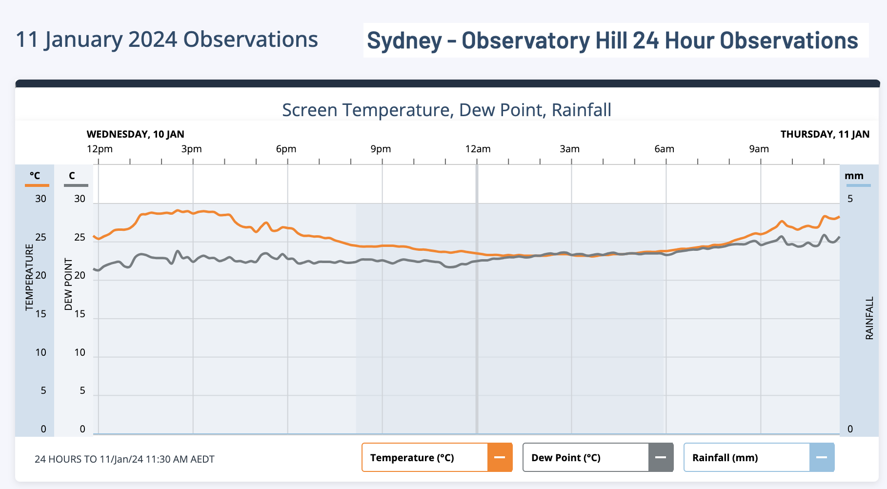
Darwin-esq DP's again in Sydney this morning.   |
|
|
|
Post by Ethereal on Jan 11, 2024 20:14:43 GMT -5
Sydney's muggiest day on record Sydneysiders are sweating like a marathon runner in Marble Bar today as humid air from the Tasman Sea creates Darwin-like mugginess across the city. Evaporated moisture from a tongue of abnormally warm water flowing near the NSW coastline is being carried into the Sydney Basin by onshore winds. This airborne moisture is making it harder for people’s bodies to lose heat through the evaporation of sweat, causing an oppressive muggy feeling that’s more common in tropical cities like Darwin or Cairns. Sydneysiders are sweating like a marathon runner in Marble Bar today as humid air from the Tasman Sea creates Darwin-like mugginess across the city. Evaporated moisture from a tongue of abnormally warm water flowing near the NSW coastline is being carried into the Sydney Basin by onshore winds. This airborne moisture is making it harder for people’s bodies to lose heat through the evaporation of sweat, causing an oppressive muggy feeling that’s more common in tropical cities like Darwin or Cairns.
Meteorologists monitor atmospheric moisture by measuring the dew point, which is the temperature the air must cool to for condensation to occur. The more moisture in the air, the higher the dew point and the harder it becomes for our bodies to cool by sweating.A typical 9am dew point in Sydney during January would be about 17ºC. On Thursday morning, Sydney’s dew point was hovering around 24 to 26ºC and reached 26.7ºC at 12:40pm, which is exceptionally high for any time of year.
Sydney’s dew point of 24.6ºC at 9am AEDT was the city’s highest 9am dew point in 13 years, making this its muggiest morning since 2011. In the past 15 years, the highest 9am dew point in Sydney was 25.9C on November 14, 2011. According to hourly historical observations from the Bureau of Meteorology, Sydney's dew point of 25.9ºC at 11am on Thursday was the city's highest hourly dew point on record. However, an analysis of extreme high dew points at Observatory Hill's weather station shows that the current site, which opened in 2017, is prone to higher dew point extremes than the old site. This may be due to the new site having more parkland in immediate proximity.
Thursday’s high dew points are making it feel 4 to 5ºC warmer than it is, with air temperatures in the mid to high twenties feeling more like the low thirties throughout the morning. Today’s abundant atmospheric moisture and heat could give rise to localised showers and thunderstorms over Sydney. Unlike most storms that move into Sydney from the west or south, these storms could form seemingly out of nowhere directly above the Sydney Basin, or drift in from the east. Keep an eye on the Sydney radar during the rest of the day to see if any storms are forming nearby.
www.weatherzone.com.au/news/sydneys-muggiest-day-on-record/1731610
|
|
|
|
Post by greysrigging on Jan 11, 2024 20:49:22 GMT -5
Sydney's muggiest day on record Sydneysiders are sweating like a marathon runner in Marble Bar today as humid air from the Tasman Sea creates Darwin-like mugginess across the city. Evaporated moisture from a tongue of abnormally warm water flowing near the NSW coastline is being carried into the Sydney Basin by onshore winds. This airborne moisture is making it harder for people’s bodies to lose heat through the evaporation of sweat, causing an oppressive muggy feeling that’s more common in tropical cities like Darwin or Cairns. Sydneysiders are sweating like a marathon runner in Marble Bar today as humid air from the Tasman Sea creates Darwin-like mugginess across the city. Evaporated moisture from a tongue of abnormally warm water flowing near the NSW coastline is being carried into the Sydney Basin by onshore winds. This airborne moisture is making it harder for people’s bodies to lose heat through the evaporation of sweat, causing an oppressive muggy feeling that’s more common in tropical cities like Darwin or Cairns.
Meteorologists monitor atmospheric moisture by measuring the dew point, which is the temperature the air must cool to for condensation to occur. The more moisture in the air, the higher the dew point and the harder it becomes for our bodies to cool by sweating.A typical 9am dew point in Sydney during January would be about 17ºC. On Thursday morning, Sydney’s dew point was hovering around 24 to 26ºC and reached 26.7ºC at 12:40pm, which is exceptionally high for any time of year.
Sydney’s dew point of 24.6ºC at 9am AEDT was the city’s highest 9am dew point in 13 years, making this its muggiest morning since 2011. In the past 15 years, the highest 9am dew point in Sydney was 25.9C on November 14, 2011. According to hourly historical observations from the Bureau of Meteorology, Sydney's dew point of 25.9ºC at 11am on Thursday was the city's highest hourly dew point on record. However, an analysis of extreme high dew points at Observatory Hill's weather station shows that the current site, which opened in 2017, is prone to higher dew point extremes than the old site. This may be due to the new site having more parkland in immediate proximity.
Thursday’s high dew points are making it feel 4 to 5ºC warmer than it is, with air temperatures in the mid to high twenties feeling more like the low thirties throughout the morning. Today’s abundant atmospheric moisture and heat could give rise to localised showers and thunderstorms over Sydney. Unlike most storms that move into Sydney from the west or south, these storms could form seemingly out of nowhere directly above the Sydney Basin, or drift in from the east. Keep an eye on the Sydney radar during the rest of the day to see if any storms are forming nearby.
www.weatherzone.com.au/news/sydneys-muggiest-day-on-record/1731610 Sydney and Darwin atm:   |
|
|
|
Post by Ethereal on Jan 11, 2024 21:45:14 GMT -5
Sydney's muggiest day on record Sydneysiders are sweating like a marathon runner in Marble Bar today as humid air from the Tasman Sea creates Darwin-like mugginess across the city. Evaporated moisture from a tongue of abnormally warm water flowing near the NSW coastline is being carried into the Sydney Basin by onshore winds. This airborne moisture is making it harder for people’s bodies to lose heat through the evaporation of sweat, causing an oppressive muggy feeling that’s more common in tropical cities like Darwin or Cairns. Sydneysiders are sweating like a marathon runner in Marble Bar today as humid air from the Tasman Sea creates Darwin-like mugginess across the city. Evaporated moisture from a tongue of abnormally warm water flowing near the NSW coastline is being carried into the Sydney Basin by onshore winds. This airborne moisture is making it harder for people’s bodies to lose heat through the evaporation of sweat, causing an oppressive muggy feeling that’s more common in tropical cities like Darwin or Cairns.
Meteorologists monitor atmospheric moisture by measuring the dew point, which is the temperature the air must cool to for condensation to occur. The more moisture in the air, the higher the dew point and the harder it becomes for our bodies to cool by sweating.A typical 9am dew point in Sydney during January would be about 17ºC. On Thursday morning, Sydney’s dew point was hovering around 24 to 26ºC and reached 26.7ºC at 12:40pm, which is exceptionally high for any time of year.
Sydney’s dew point of 24.6ºC at 9am AEDT was the city’s highest 9am dew point in 13 years, making this its muggiest morning since 2011. In the past 15 years, the highest 9am dew point in Sydney was 25.9C on November 14, 2011. According to hourly historical observations from the Bureau of Meteorology, Sydney's dew point of 25.9ºC at 11am on Thursday was the city's highest hourly dew point on record. However, an analysis of extreme high dew points at Observatory Hill's weather station shows that the current site, which opened in 2017, is prone to higher dew point extremes than the old site. This may be due to the new site having more parkland in immediate proximity.
Thursday’s high dew points are making it feel 4 to 5ºC warmer than it is, with air temperatures in the mid to high twenties feeling more like the low thirties throughout the morning. Today’s abundant atmospheric moisture and heat could give rise to localised showers and thunderstorms over Sydney. Unlike most storms that move into Sydney from the west or south, these storms could form seemingly out of nowhere directly above the Sydney Basin, or drift in from the east. Keep an eye on the Sydney radar during the rest of the day to see if any storms are forming nearby.
www.weatherzone.com.au/news/sydneys-muggiest-day-on-record/1731610 Sydney and Darwin atm:   Totally gross, nauseating weather. As a subtropical apologist, this is definitely one of my least favourite conditions....We shouldn't appropriate darwin's horrible wet season climate lmao |
|
|
|
Post by Crunch41 on Jan 11, 2024 23:38:30 GMT -5
Slushy snow Tuesday, fluffier snow Wednesday, and heavy snow forecast tomorrow followed by cold weather. Winter is coming on strong after a very lame start.  December was record warm and didn't snow at all. January hasn't dropped below 24F yet at the airport, currently 8.5F above normal month-to-date. But it should drop well below zero (-18C) Sunday night. Further inland there could be high temps below zero this weekend.
|
|
|
|
Post by cawfeefan on Jan 12, 2024 0:00:45 GMT -5
Sydney and Darwin atm:   Totally gross, nauseating weather. As a subtropical apologist, this is definitely one of my least favourite conditions....We shouldn't appropriate darwin's horrible wet season climate lmao Let alone be a visitor from Melbourne and experience record breaking dew points on my first day. Beautiful city btw, but pls turn down the humidity! |
|
|
|
Post by greysrigging on Jan 12, 2024 3:32:19 GMT -5
Totally gross, nauseating weather. As a subtropical apologist, this is definitely one of my least favourite conditions....We shouldn't appropriate darwin's horrible wet season climate lmao Let alone be a visitor from Melbourne and experience record breaking dew points on my first day. Beautiful city btw, but pls turn down the humidity! Harden up Princess... lol  Try Darwin for a holiday in Oct-Apr.... its brutal for the unacclimatized.... We do these DP's from October to April... becomes normal once ya used to it.... |
|
|
|
Post by shalop on Jan 12, 2024 10:34:38 GMT -5
|
|
|
|
Post by jetshnl on Jan 12, 2024 10:45:16 GMT -5
Was actually -46.6C between hourly obs. edit: Météo has also posted about this |
|
|
|
Post by Beercules on Jan 12, 2024 11:25:04 GMT -5
Farrrrkkkkkk A part of me wishes I was there. Forecast -38/-50C , clear skies. Can't even begin to comprehend this, what it is, and what it must feel like. |
|
|
|
Post by Ethereal on Jan 12, 2024 17:57:59 GMT -5
Let alone be a visitor from Melbourne and experience record breaking dew points on my first day. Beautiful city btw, but pls turn down the humidity! Harden up Princess... lol  Try Darwin for a holiday in Oct-Apr.... its brutal for the unacclimatized.... We do these DP's from October to April... becomes normal once ya used to it.... As a gardener, I sweat and stink like a pig when I'm out in such conditions (and I actually don't sweat that easily). I don't know how you guys do it. lol |
|
|
|
Post by rozenn on Jan 12, 2024 19:00:32 GMT -5
Quite the sharp dividing line on the 0°C isotherm map predicted for Tuesday:  |
|
|
|
Post by Crunch41 on Jan 13, 2024 0:33:19 GMT -5
Active winter pattern in the US. Canada, too.
Purple = Winter Weather Advisory Pink = Winter Storm Warning Orange = Blizzard Warning Blue is mostly wind chill advisory or warning, except the royal blue is an avalanche warning Western Oregon has an Ice Storm Warning  The large brown area is a wind advisory, gold is wind warning
Green is flooding
North and west in Canada the warnings are mostly for extreme cold, with a few blizzard warnings. Eastern Canada is winter storm or wind warnings.
|
|
|
|
Post by Steelernation on Jan 13, 2024 0:58:30 GMT -5
Arctic front moved through tonight, temp dropped from 30 to 16 (-1 to -9 c) in just 10 minutes this evening. About to crack the negatives now.
Had about 2” (5 cm) of snow but the wind made the conditions driving back from the airport nearly a whiteout. Both blowing snow all over the road and the falling snow was blowing in the air.
|
|
|
|
Post by ilmc90 on Jan 13, 2024 9:21:04 GMT -5
Been a very active weather week here. Got approximately 10 in/25 cm of snow last weekend but the snowpack has since been obliterated by two rainstorms - one on Tuesday night (1.69 in/43 mm) and another one last night (0.44 in/11 mm). Also been quite windy with wind advisories on Tuesday and again today. Mild and breezy this morning with temperatures in the mid-50s.
Next week looks much colder with highs below freezing and a few chances of snow.
|
|
|
|
Post by Doña Jimena on Jan 13, 2024 14:50:57 GMT -5
Temperatures are below normal for this time of year. -12C in the morning and -8C in the evening in Riga. Daybreak has been beautiful at least:  |
|
|
|
Post by rozenn on Jan 13, 2024 19:58:32 GMT -5
Creepy map  |
|
|
|
Post by srfoskey on Jan 14, 2024 1:41:27 GMT -5
Provisional wind gusts report from yesterday's rediculous wind event (and QLCS)
279
NOUS42 KMHX 100333
PNSMHX
NCZ029-044>047-079>081-090>092-094-193>196-198-199-203>205-101531-

Public Information Statement
National Weather Service Newport/Morehead City NC
1031 PM EST Tue Jan 9 2024

...HIGHEST WIND REPORTS (40+ mph) through 1030 pm...

Location                     Speed     Time/Date       Provider

...North Carolina...

...Beaufort County...
Washington (OCW AWOS)        48 MPH    0525 PM 01/09   AWOS
NC Fire RAWS No. 4           46 MPH    0646 PM 01/09   RAWS
Aurora 5.6 NE (Pamlico Aqua  42 MPH    0645 PM 01/09   NC-ECONET
Bath                         41 MPH    0845 PM 01/09   DAVIS
...
That storm really exceeded my expectations. I was still in Durham when it was happening, and the rain was some of the hardest I've seen in my life. The power flickered a few times and winds gusted to 69 mph at RDU.
Now I am back in Norman, and it is 4°F (-15.5°C) with a -14°F (-25.5°C) windchill. I like cold, but that's a little excessive. Any time windchills get below -10°F (-23°C) I start to think about how this is the type of cold that can really kill people.
|
|


