|
|
Post by alex992 on Aug 12, 2021 9:38:58 GMT -5
Great August forecast IMO. Decently variable with a couple of very hot days and some cooler, more objectively pleasant days. Most nights are pretty cool/comfortable as well. Throw in some more thunderstorms and it's a picture perfect forecast for this time of year. |
|
|
|
Post by rozenn on Aug 12, 2021 10:48:05 GMT -5
Gonna be in Greece last week of August. Looks nice and warm still there:  |
|
|
|
Post by Mörön on Aug 14, 2021 9:57:35 GMT -5
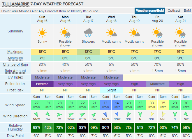
I'll be back in Cranbrook on Monday (for a few days). Nice looking cold front coming through on Tuesday.   |
|
|
|
Post by jgtheone on Aug 14, 2021 10:53:44 GMT -5
Boiling hot mid-august forecast  |
|
|
|
Post by Ariete on Aug 14, 2021 11:02:36 GMT -5
|
|
|
|
Post by Morningrise on Aug 14, 2021 11:21:14 GMT -5
One last hot weekend (probably our final burst of real heat this year) and then dropping to much milder conditions afterwards. You know you're in the final stretches of summer here when the nights start to be regularly in the single digits.  |
|
|
|
Post by rozenn on Aug 14, 2021 18:21:27 GMT -5
|
|
|
|
Post by chesternz on Aug 15, 2021 2:49:16 GMT -5
Highs a bit warmer than normal:  |
|
|
|
Post by Benfxmth on Aug 15, 2021 5:08:40 GMT -5
Everyone: Do you think I should continue posting NWS-esque forecast discussions (used a blend of weather models this time)?   .SYNOPSIS...
High pressure will continue offshore today. A cold front will approach Monday, and then push through Tuesday, with high pressure building over the area next weekend.
.NEAR TERM /UNTIL 6 PM THIS EVENING/...
As of 9:00 AM Sun...No changes to forecast with another hot and sunny day on tap.
Prev disc...Upper ridging will continue today keeping the
region clear and dry. Should be another hot day with highs mid to upper 90s most spots...little cooler for the beaches.
.SHORT TERM /6 PM THIS EVENING THROUGH 6 AM MONDAY/..
As of 9:00 AM Sun...Should be another quiet, warm night with high pressure and upper ridge still in control. Overnight lows in the lower to mid 70s for the area.
.LONG TERM /MONDAY THROUGH SATURDAY/...
As of 9:00 AM Sunday...Warm conditions will continue Monday. Onshore flow with high pressure drifting southwards should make for slightly cooler temperatures—in the lower to mid 90s range. Low-level moisture will work its way into the area Monday evening as a cold front approaches from the northwest, making for overnight dew points in the lower to mid 70s. Some low cloud cover is likely as well; these, and along with steady south wind 5 to 15 mph at the surface, should make for overnight lows in the lower-mid 70s for most of the area, and mid 70s for beaches.
Tuesday...Isolated sprinkles may develop by daybreak Tuesday morning along the frontal boundary, but a lack of mid-level moisture should keep most of the area dry; too isolated to mention in forecast. Clearing is likely, though some low cloud cover may persist later in the day, with highs slightly below normal; in the lower to mid 80s for the region.
Wednesday through Thursday...Model guidance points to upper troughing traversing central Europe and Scandinavia, making for unsettled weather with better mid-level moisture elevating precipitation probabilities for central Italy. Scattered showers/thunderstorms are likely during the afternoon hours, occurring with peak daytime heating along sea breeze fronts. Highs near to slightly below normal, in the lower to mid 80s, and lows in the mid-60s.
Friday through Saturday...a more typical summertime pattern should build back in, with high pressure building to the southwest, with mostly clear conditions to prevail. Highs near to slightly above normal, in the upper 80s-lower 90s range, and lows in the mid-upper 60s. |
|
|
|
Post by Mörön on Aug 16, 2021 0:15:24 GMT -5
Atlin looking pretty chilly. Pretty sure this is quite a bit below normal, especially the lows.  |
|
|
|
Post by alex992 on Aug 16, 2021 7:06:09 GMT -5
Still the middle of summer here -   |
|
|
|
Post by Benfxmth on Aug 17, 2021 4:04:30 GMT -5
Looks like a round of showers/T-storms mid/late week here before a warming trend this weekend.      
.SYNOPSIS...
A cold front will continue pushing southeastwards through the day today. An upper trough will bring unsettled weather for mid-late week, before high pressure builds back in by the weekend.

.NEAR TERM /UNTIL 6 PM THIS EVENING/...
As of 9:00 AM Tue...Cold front has pushed through early this morning, with scattered cumuliform and stratocumulus clouds persisting this morning, clearing should occur by the afternoon. Drier air has begun filtering in, expect dew points to drop to the lower-mid 60s this afternoon, but like many summertime cold fronts, doesn't do that much to nudge dew points far below the 60s. No changes made to forecast since the 12Z model suite.

Prev disc...Isolated showers can't be ruled out by daybreak Tuesday morning along the frontal boundary, but a lack of mid-level moisture should keep most the area dry. Nudge up Tuesday's high up slightly as the 12Z weather model runs point to skies becoming clear by the afternoon. Low level thickness values clearing skies should support highs near climo—in the mid to upper 80s today.

.SHORT TERM /6 PM THIS EVENING THROUGH 6 AM WEDNESDAY/..
As of 9:00 AM Tue...Not much change to the upper, or surface pattern, though increasing mid-level moisture should begin moving in from the northwest, especially after 00Z. Lows near climo, in the mid to upper 60s, with mostly clear skies, albeit with patchy stratocumulus and/or cumulus coverage possible.

.LONG TERM /WEDNESDAY THROUGH MONDAY/...

As of 9:00 AM Tue...Wednesday through Thursday...An upper trough will slowly continue to sag southwards, elevating precipitation chances Wednesday and Thursday. There will decent mid-level moisture, surface Td's in the upper 60s with PW values in the 1.4-1.6" region, and instability; MUCAPE values around 1000-1500 J/kg, locally up to 2000 J/kg near the coast, present and enough to support showers and scattered thunderstorms afternoon and evening, and while mid/upper forcing will be modest, sea-breeze frontal forcing should be sufficient to initiate shower/thunderstorm formation. While GFS and ICON remain unenthusiastic on rainfall amounts, expect between a tenth and a quarter of rainfall falling between Wednesday and Thursday, locally higher amounts possible. Most shower activity should wane after sunset, but not ruling out the possibility of isolated/widely scattered showers developing in the southern tier near the coast Wed night, with decent instability in place. Highs slightly below climo, in the lower to mid 80s, with lows in the mid to upper 60s.

Friday...Latest GFS and ECMWF model runs have come with a shortwave trough digging south across central Italy, albeit with PW's falling to 1.2-1.4" and MUCAPE values still in the 1000-1500 J/kg away from the coast, so isolated/widely scattered T-storms can't be ruled out. Still some disagreement among weather models but will add a 20% PP for Friday's forecast. Highs near normal, in the mid to upper 80s.

Saturday through Monday...a more typical summertime pattern should build back in, with high pressure building to the southwest, with mostly clear conditions to prevail. Highs near to slightly above normal, in the upper 80s-lower 90s range, and lows in the mid-upper 60s.
|
|
|
|
Post by Moron on Aug 17, 2021 5:34:23 GMT -5
Wiluna
Starting quite hot, becoming stable, above average and pleasant.
August 18- 31/16- partly cloudy
August 19- 30/13- mostly sunny
August 20- 25/11- sunny
August 21- 27/8- mostly sunny
August 22- 25/10- mostly sunny
August 23- 25/8- mostly sunny
August 24- 25/10- mostly sunny
|
|
|
|
Post by rozenn on Aug 17, 2021 6:46:01 GMT -5
Atlin looking pretty chilly. Pretty sure this is quite a bit below normal, especially the lows.  Yeah looks more like September temps for there. |
|
|
|
Post by jgtheone on Aug 17, 2021 9:33:56 GMT -5
Remaining above average until the start of next week  |
|
Deleted
Deleted Member
Posts: 0
|
Post by Deleted on Aug 17, 2021 13:45:48 GMT -5
August failing to do anything once again. At this rate we won't even reach 150 sun hours.  |
|
|
|
Post by irlinit on Aug 18, 2021 1:55:24 GMT -5
August failing to do anything once again. At this rate we won't even reach 150 sun hours.  Shocking summer, it really has been. In fact the whole year is just a write off. I remember two separate weeks of warm/hot weather, one at the start of June and one in July. Other than that it has been overcast cloudy and cool. I don’t remember a year as bad as this, not since 2008/2007 |
|
Deleted
Deleted Member
Posts: 0
|
Post by Deleted on Aug 18, 2021 2:14:31 GMT -5
August failing to do anything once again. At this rate we won't even reach 150 sun hours.  Shocking summer, it really has been. In fact the whole year is just a write off. I remember two separate weeks of warm/hot weather, one at the start of June and one in July. Other than that it has been overcast cloudy and cool. I don’t remember a year as bad as this, not since 2008/2007 2007 at least had a warm and sunny spring. 2008 was probably the last time we had a year this bad, when it snowed in April and October. |
|
|
|
Post by Morningrise on Aug 18, 2021 7:34:13 GMT -5
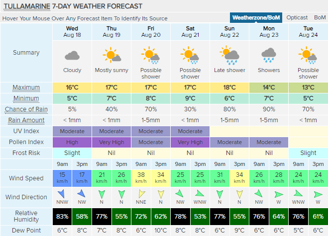
Looks like fall weather is off to an early start for us this year. Normally this might annoy me, but the last two months have been so spectacular that I simply can't complain! Some cooler, wetter weather makes for a nice change of pace right about now.  |
|
|
|
Post by MET on Aug 18, 2021 13:52:24 GMT -5
We could equal our highest - yes, "highest", temperature of the month on saturday...  |
|