|
|
Post by jgtheone on Sept 8, 2021 9:52:12 GMT -5
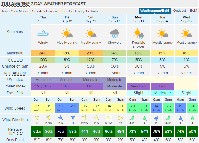
Very springlike conditions  |
|
|
|
Post by knot on Sept 8, 2021 16:41:21 GMT -5
Classic spring swing   |
|
|
|
Post by ilmc90 on Sept 8, 2021 17:35:50 GMT -5
Friday and the weekend looks really nice.   |
|
|
|
Post by Iwantsnow on Sept 8, 2021 21:22:50 GMT -5
Comfortable, then one hot day possible on Saturday. Possibly the last 30C high. So far September has been mild and not exciting, but it can be a stable month like that. Good for just about anything outside (except the beach).
 |
|
|
|
Post by Mörön on Sept 9, 2021 10:17:04 GMT -5
Getting chilly at the end   |
|
Deleted
Deleted Member
Posts: 0
|
Post by Deleted on Sept 9, 2021 11:40:34 GMT -5
Another clownish cloud forecast from Cloudonline. I doubt such a cloudy spell has ever happened here, even in the middle of winter.  |
|
|
|
Post by ral31 on Sept 9, 2021 20:41:22 GMT -5
Wunderground is showing 60F tonight! Low humidity the next couple of days. Looks wet next week with possibly tropical influence.  |
|
|
|
Post by Morningrise on Sept 10, 2021 7:26:09 GMT -5
Sounds about right for mid-September...  |
|
|
|
Post by alex992 on Sept 11, 2021 6:52:00 GMT -5
  Besides rain chances going up, it's an absolute borehole of a forecast. |
|
|
|
Post by Mörön on Sept 11, 2021 12:26:15 GMT -5
|
|
|
|
Post by jgtheone on Sept 12, 2021 9:15:27 GMT -5
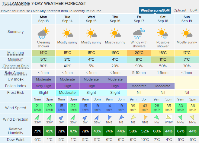
A few chilly mornings coming up, otherwise remaining seasonable.  |
|
|
|
Post by rozenn on Sept 12, 2021 22:48:00 GMT -5
|
|
|
|
Post by flamingGalah on Sept 13, 2021 18:45:17 GMT -5
Some rain tomorrow, then the dry theme continues  |
|
|
|
Post by ral31 on Sept 13, 2021 20:17:38 GMT -5
Flash flood watch as Tropical Storm Nicholas approaches. Could see 5-10 inches of rain.  |
|
|
|
Post by dunnowhattoputhere on Sept 13, 2021 21:34:26 GMT -5
not too bad  |
|
|
|
Post by Strewthless on Sept 14, 2021 11:01:33 GMT -5
Good for 2nd half of September  |
|
|
|
Post by Ariete on Sept 14, 2021 11:45:05 GMT -5
One normal high. On Saturday. Boke.
|
|
|
|
Post by Benfxmth on Sept 15, 2021 1:42:16 GMT -5
Summer's over (note: ECMWF is usually the coolest weather model though hence the temp discrepancy)        .SYNOPSIS...
High pressure will remain in control into late week, with dry weather continuing. A cold front will approach, cross the area Thursday night, and then stall for the weekend, bringing a round of unsettled weather.
.NEAR TERM /UNTIL 6 PM TONIGHT/...
As of 7:00 AM Wed...The near term forecast remains in good shape with only small adjustments needed for the early morning update. A weak surface trough over the western Med will move closer to the area. With a plume of moisture above the 700 hPa level advected from the southwest, persistent mid and high-level cloud cover will decrease insolation today, and limit highs to the lower-mid 80s. Precipitation chances are minimal today with dry air aloft in the low levels, and with high pressure remaining overhead.
.SHORT TERM /6 PM TONIGHT THROUGH 6 AM THURSDAY/...
As of 7:05 AM Wed...Aforementioned surface trough will move closer, while a surface low will develop over the North Sea as well, influencing the weather here. This will lead to a tightening of the pressure gradient and low-level flow becoming southeasterly. Continued moisture advection in the mid and upper levels should make for persistent mid & high cloud cover as well, so expect mild lows--in the mid to upper 60s.
.LONG TERM /THURSDAY THROUGH TUESDAY/...
As of 7:30 AM Wed...High pressure continues to influence the early part of the forecast as aforementioned upper ridge remains over the region through Thursday keeping us dry. A period of unsettled weather is expected late week and into weekend as a sluggish front moves through the region. Temps will be dropping to values more typical of early fall Sunday, and early next week.
Thursday through Friday...As high pressure pulls away southeastwards, deeper moisture will be funneled north ahead of a cold front, which should cross the area around 00Z Friday, bringing shower/T-storm chances Thursday night. Instability will increase through the night, and given deep-layer shear in the order of 40-50 knots, a couple of isolated strong/severe thunderstorms are possible Thursday night/Friday morning along the frontal boundary. Cloud cover should limit highs to the upper 70s to lower 80s, with Thursday night seeing lows in the upper 60s, with some coastal locales possibly seeing lows in the lower 70s.
Late Friday through Saturday...Aforementioned cold front should stall just south through the area even as it tries to push southwards, and continue to provide shower/thunderstorm chances. Highs in the upper 70s with lows in the mid 60s thanks to dew points remaining in the lower 60s through the night.
Sunday through Tuesday...Discrepancy among weather models WRT to temps remains; ECMWF 12Z depicts an upper trough helping usher in a cooler and drier airmass southwards Sunday, with high pressure briefly building in Monday and Tuesday, whereas GFS and ICON depict high pressure building into Italy Sunday-Tuesday. Model trends with this timeframe will be kept an eye on, but regardless of the pattern, the weekend and early next week look to be mostly dry, with highs in the upper 70s, with lows in the upper 50s to lower 60s.
|
|
|
|
Post by Babu on Sept 15, 2021 2:05:02 GMT -5
|
|
|
|
Post by Doña Jimena on Sept 15, 2021 2:27:53 GMT -5
That may have been one of the most out-of-context videos I've watched in a while. Thought you were getting summer heat in the coming days and was gonna make a "meanwhile in Umeå..." comment but then I realized you were getting just as shit weather as I've thought I had updated my location to Slanchev Bryag, Bulgaria. I am enjoying last week of summer warmth here. 🙂 |
|