|
|
Post by alex992 on Sept 23, 2021 7:43:28 GMT -5
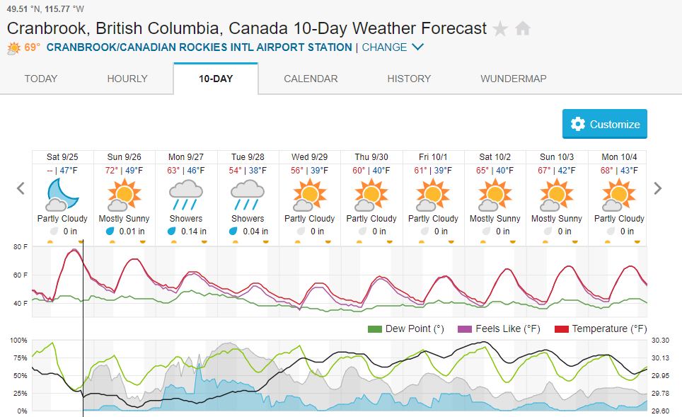
Forecast for the rest of my time on the penis:   At least it looks stormy I guess. |
|
|
|
Post by ilmc90 on Sept 23, 2021 8:01:45 GMT -5
Noice   |
|
|
|
Post by Morningrise on Sept 23, 2021 8:54:24 GMT -5
A minor but welcome upgrade to our forecast, this is looking damn fine for late September!   |
|
|
|
Post by rozenn on Sept 24, 2021 3:40:29 GMT -5
Trending cooler  |
|
|
|
Post by MET on Sept 24, 2021 8:08:12 GMT -5
It is going from mild to the first proper autumnal weather in the next few days.  |
|
|
|
Post by knot on Sept 25, 2021 16:07:15 GMT -5
Inland trough set to deliver about 100 mm over the week   |
|
|
|
Post by tommyFL on Sept 25, 2021 17:40:00 GMT -5
|
|
|
|
Post by Mörön on Sept 25, 2021 20:51:39 GMT -5
Another cold front followed by gradually increasing temps. Same pattern as before.  |
|
|
|
Post by Strewthless on Sept 26, 2021 8:55:55 GMT -5
The party's over.  |
|
|
|
Post by MET on Sept 26, 2021 20:55:54 GMT -5
Finally some proper late September/October weather arriving.   |
|
|
|
Post by AJ1013 on Sept 27, 2021 10:26:45 GMT -5
Pretty solid forecast  |
|
|
|
Post by tommyFL on Sept 27, 2021 16:10:41 GMT -5
|
|
|
|
Post by ral31 on Sept 27, 2021 22:22:37 GMT -5
Dry stretch with clear skies has ended. Humid and wet the next few days.  |
|
|
|
Post by flamingGalah on Sept 28, 2021 17:34:18 GMT -5
Feels like we have jumped straight from summer to winter  |
|
|
|
Post by rozenn on Sept 28, 2021 17:41:57 GMT -5
|
|
|
|
Post by Ariete on Sept 28, 2021 18:52:52 GMT -5
Handsome automne atmosphere:
|
|
|
|
Post by jgtheone on Sept 29, 2021 9:20:30 GMT -5
Showers, I guess  |
|
|
|
Post by kronan on Sept 29, 2021 9:55:02 GMT -5
Something out of Bergen.  |
|
|
|
Post by Benfxmth on Sept 30, 2021 2:55:06 GMT -5
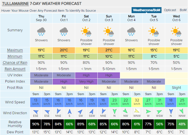
Probably the last possible shot for 80°F today?    
.SYNOPSIS...
High pressure will extend over the area through the weekend. A more active weather pattern is expected early next week, with a cold front approaching, and likely pushing through the area Tuesday with waves of low pressure developing along it.

.NEAR TERM /UNTIL 6 PM TONIGHT/...
As of 8:00 AM Thursday...Latest analysis shows surface high pressure and upper ridging extending over the area from the W and SW respectively. With MUCAPE values around 1.5 KJ/kg, guidance indicates isolated to widely scattered showers and thunderstorms possible along the sea breeze late this afternoon, so will keep low chance PoP's in the forecast today. Low-level thickness values and 850 hPa temps in the 13-14°C range should support highs in the upper 70s to lower 80s today.

.SHORT TERM /6 PM TONIGHT THROUGH 6 AM FRIDAY/...
As of 8:10 AM Thursday...Azores high pressure will continue to control the weather for the area. Any convection that does develop should diminish quickly after sunset with loss of heating. Lows in the lower 60s tonight expected.

.LONG TERM /FRIDAY THROUGH WEDNESDAY/...

As of 8:15 AM Thursday...A mild and largely dry pattern will persist through late week with temps staying above climo for the beginning of October. Dominant ridge begins to break down by Saturday as a more active weather pattern emerges.

Friday and Saturday...Mild temps expected both days. Some guidance suggests a weak shortwave trough aloft will move through central Italy Friday afternoon, coincident with peak heating, warrants PoPs in the 20% range most areas. Some limited instability in the order of 500-1000 J/kg and decent low-level moisture could support isolated pulse showers/thunderstorms along weak sea breezes. High cloud cover and slightly lower heights aloft should reduce highs slightly for the time period, but still nonetheless above climo--in the mid to upper 70s F.

Saturday through Sunday...Upper level ridging pattern shifts southeast Saturday in response to a substantial upper trough moving south from the North Atlantic and into northwestern Europe by Sunday. Reduced insolation from cloud cover ahead of the front should reduce highs somewhat, to the mid-70s.

Monday through Wednesday...Still some uncertainty of timing of the cold front's arrival, or whether it will push through or stall, but either way, Monday through Tuesday have the best precipitation chances in the long-term forecast, with deeper moisture aloft ahead of the cold front and PW's surging to the 1.6-1.8” range--as depicted by GFS and ECMWF Monday. Will forecast highs in the lower 70s.
|
|
|
|
Post by Mörön on Sept 30, 2021 17:29:55 GMT -5
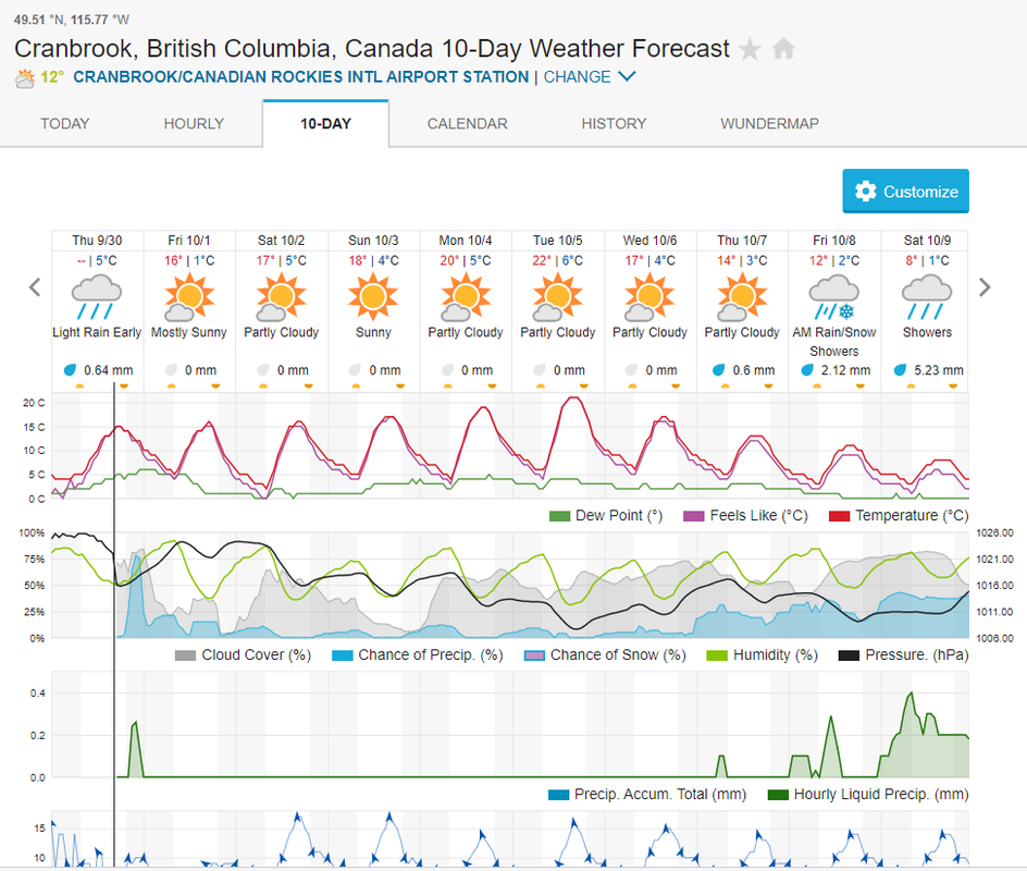
First snowflake in the forecast and a nice chilly day on 10/9   |
|