|
|
Post by aabc123 on Jul 29, 2024 16:29:01 GMT -5
Extremely large amounts of rain in the southern and eastern parts of the country - in one go, 120% of the monthly norm came off! Here are the top precipitation amounts per country from the site of the environmental agency. All all are in the south. At the same time, for example, in certain places on the west coast there was 0.0mm of precipitation. Tuulemäe is located on the Haanja plateau, this is the reason why it got the so much. Most of the rain fell at night.  |
|
|
|
Post by rozenn on Jul 29, 2024 17:57:26 GMT -5
Awesome rain totals in the Baltics! Big time heat in the Souff today  Quite humid in parts as well, especially in SW France, with dews north of 25°C combined with temps in the mid-30s. |
|
|
|
Post by greysrigging on Jul 29, 2024 18:38:27 GMT -5
Severe frosts in eastern AU forecast for the next week: ( source: Retired Weather Man, QLD )  |
|
|
|
Post by cawfeefan on Jul 30, 2024 4:13:26 GMT -5
Strong rainfall gradient across Melbourne this month. First image is Avalon in the west and second image is Ferny Creek in the east. Rainfall figure is the bottom right cell. Mind you, Ferny Creek is at 513m elevation, but still the difference is rather staggering.   |
|
|
|
Post by jgtheone on Jul 30, 2024 5:24:12 GMT -5
24h rainfall totals by 12 UTC (i.e. 12-12 UTC).
117 mm in Riga city. Even higher totals were reported from Kalnciema (SW of Riga) with 193 mm.
Five years ago, when Helsinki was hit by heavy rain and the metro was closed, the rainfall was half that of Riga.
SE Latvia is the Essendon of Latvia |
|
|
|
Post by rozenn on Jul 30, 2024 13:41:48 GMT -5
Hot today  Quite humid too, lots of dews in the mid-upper 70s °F. Most humid in Paris region was Changis, with a 33.0/26.1°C T°/dp combo @ 7 pm (91/79°F).  |
|
|
|
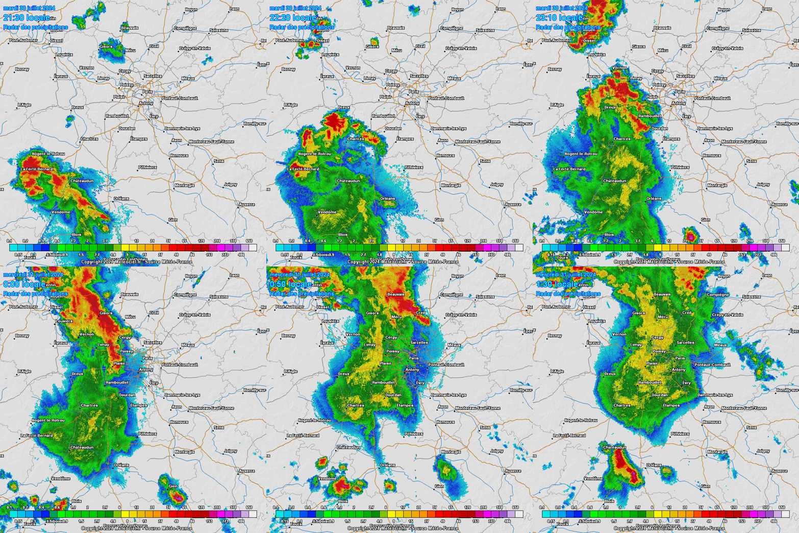
Post by rozenn on Jul 30, 2024 18:37:32 GMT -5
Who gets cucked again with lame ass stratiform rain while places just west get the storms?  |
|
|
|
Post by greysrigging on Jul 30, 2024 23:41:27 GMT -5
Looks like some unseasonal rain in the Pilbara, Kimberley of WA and the north western desert regions of SA. Five days of rain for parts of northwestern WA and SA: ( source: Weatherzone )  Parts of the Pilbara, Kimberley, WA’s interior, and inland SA are about to see a prolonged period of wet weather, as an upper-level trough moves over the region. The image below shows the upper-level trough over the Pilbara region on Friday night, which will slowly progress further east into central Australia on the weekend.  Images: 500 hPa wind forecast at 8pm AWST on Friday August 2, according to ECMWF. The image below shows that widespread falls of 15 to 30mm is forecast in the next five days across the Pilbara, parts of the Kimberley, the WA interior and central SA, with more isolated totals of 30 to 60mm on the forecast.  Image: Accumulated 5- day rain forecast leading up to 11am AWST on Monday, August 5, according to ECMWF. While rain should begin across parts of the Pilbara and Kimberley regions on Wednesday evening in response to a surface trough, the rain should intensify over the weekend as the upper-level trough impacts the region. Meanwhile a strong cold front is approaching southwest WA, bringing severe thunderstorms, ferocious winds and heavy rainfall to the region in the coming days. The heaviest rain is likely in the Pilbara and Kimberley region later Thursday into Friday and again Friday night into Saturday as significant uplift occurs ahead of the trough. Falls of 10 to 15mm in three hours could fall over these areas during this period. Looking ahead, rain should ease across much of WA later Sunday into Monday, as the rain focuses on central SA. |
|
|
|
Post by rozenn on Jul 31, 2024 17:59:45 GMT -5
24- hour totals in a 100 km radius around Paris. Of course the city gets fuck all in terms of action. Lame shit, and I'm not even there. All this nothingness with dews up to 23°C/73°F. Useless humidity.  |
|
|
|
Post by greysrigging on Jul 31, 2024 20:06:30 GMT -5
All the AU Capital Cities ended up with a slightly warmer than average July.
Min and max anomalies:
Darwin = +0.7c/+0.6c
Brisbane = +0.7c/-0.6c
Sydney = +1.3c/+1.6c
Canberra = +0.4c/-0.3c
Melbourne = +1.0c/0.0c
Hobart = +0.5c/+1.0c
Adelaide = +0.1c/+0.8c
Perth = +1.6c/+0.9c
|
|
|
|
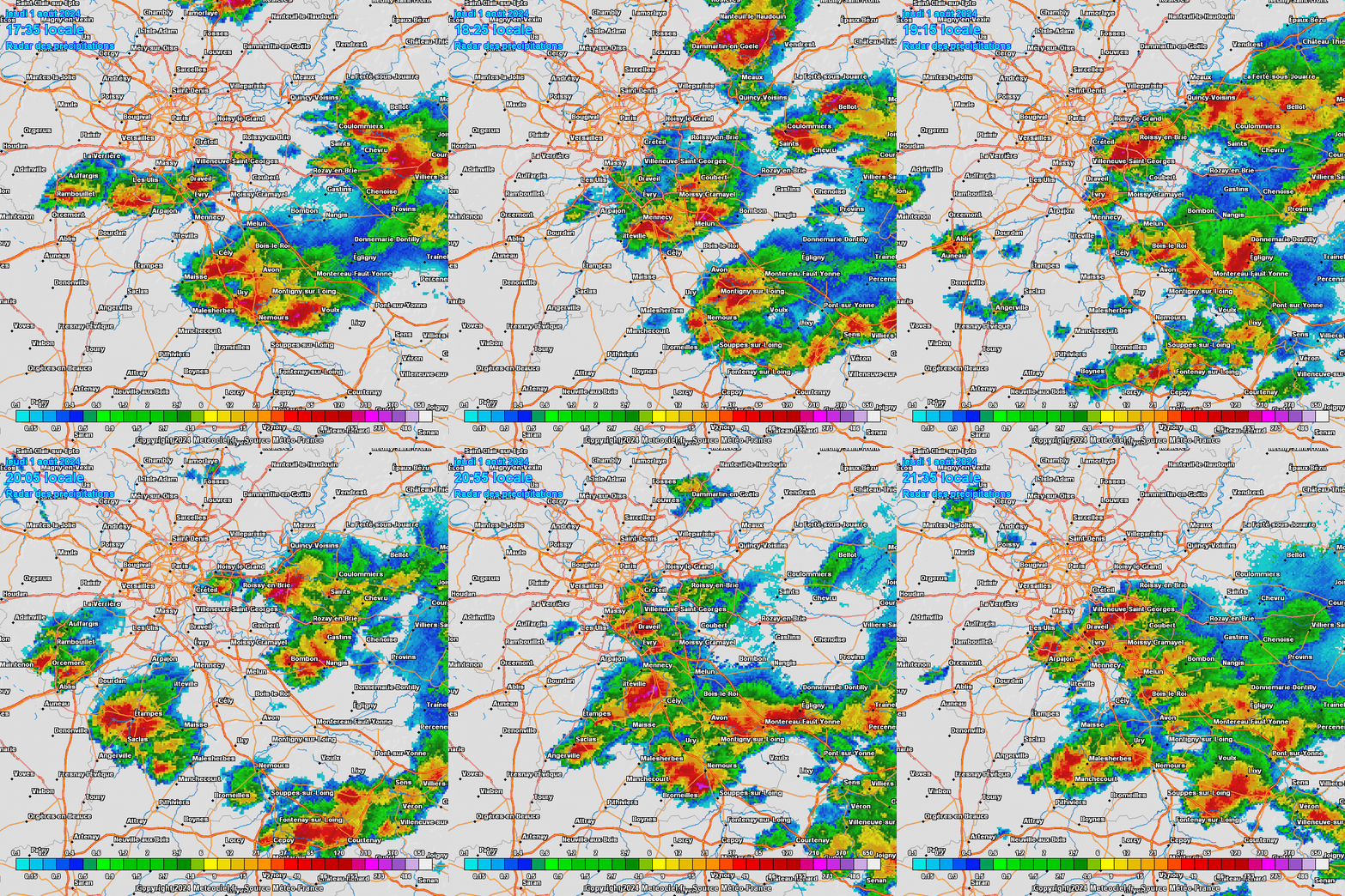
Post by rozenn on Aug 1, 2024 15:05:26 GMT -5
4-hour SE Paris radar loop. The city is a thunderstorm factory rn. Good for the folks a few dozen km E and S of the city.  |
|
|
|
Post by Benfxmth on Aug 1, 2024 18:23:36 GMT -5
High/low today here is 94.9/74.9°F (34.9/23.8°C). Likely one of the hottest daily max temps this summer. Also had dewpoints reach 80°F for the first time in over a week right behind the seabreeze. Felt delightful all times of day today. The hot humid air gives me perverse pleasure like none other. Much better than boring gay ass wishy washy low-mid 80s highs with 60°F dewpoints and northeasterlies bullshit in mid crummer, like it was last weekend. Too early to pinpoint the impacts of potential tropical cyclone Invest 97L next week, though either way, a return to cooler and stormier pattern for the SE US looks likely:   |
|
|
|
Post by psychedamike24 on Aug 2, 2024 2:14:26 GMT -5
 Nanjing weather forecast |
|
|
|
Post by greysrigging on Aug 2, 2024 3:00:46 GMT -5
Some unseasonal winter ( August ) rainfall in Karratha ) WA Pilbara )   |
|
|
|
Post by rozenn on Aug 2, 2024 18:33:43 GMT -5
|
|
|
|
Post by psychedamike24 on Aug 3, 2024 1:43:12 GMT -5
Why is it so humid in Metropolitan France this summer? I was in Paris for a few days around late July/early August around 10 years ago and it was nowhere near 30s C with 20s C dew points back then...
|
|
|
|
Post by greysrigging on Aug 3, 2024 5:33:15 GMT -5
AU extremes today ( 3rd of August )  |
|
|
|
Post by greysrigging on Aug 5, 2024 5:28:18 GMT -5
Warm Aussie July despite deep freeze. ( source: Weatherzone )  It got seriously cold at times in Australia in July, with Tasmania experiencing a deep freeze in the first week of July as the tiny town of Liawenee dipped to –13.5°C. Other parts of the country also saw extremes of cold, but overall, Australia was much warmer than usual with a nationally averaged temperature that was 0.7°C above the long-term average. Maximum temps in July 2024 were 0.62°C above the long-term average. Minimum temps in July 2024 were 0.78°C above the long-term average. If you look at the chart below, you can see that most of Australia had temps of up to a degree above average (the pale yellow zone) or in the 1-2 degree above average range (bright yellow).  Only comparatively small portions of the country experienced cooler than usual temps (pale green). One of the warmest areas was southwest WA, where Perth Airport experienced its second-warmest July on record, with temps 1.4°C above the long-term average. Given that Perth exceeded its monthly rainfall for the first time in a year (total 170 mm, July average 146.3 mm), and that you'd normally expect cooler temps with wet weather, it's possible that the warmth anomaly might have contained some indications related to climate change. But perhaps the most interesting feature on the chart above is Tasmania.  Image: The race for Tasmania's average July min temps to be below average went down to the wire. Source: @nemototasmania Instagram. As mentioned, Liawenee dipped to –13.5°C in the first week of the month, which was the state's second-coldest night on record, and remains the coldest temp recorded in Australia to date in 2024. And that wasn't just a one-off. Between July 2 and 7, Liawenee fell below –10°C over four consecutive frigid nights, then "warmed up" to –9.7°C, then fell below –10°C again. That spell of intensely cold nights lasting almost a week seemed to snap-feeze half of Tasmania, and locals are still talking about it.  But Tasmanian days were not particularly cold for much of July, which bumped up the overall average. Tasmania's nights were marginally colder than average by just 0.06°C (the only state or territory to be below average for either max or min temps in July 2024). Tasmania's days were 0.34°C warmer than usual averaged across the state. Indeed, Hobart's mean daily maximum temperature of 12.9 °C was 1.1 °C above the long-term average of 11.8 °C. They say a week's a long time in politics, and it’s a long time in weather too. But a month is longer, and a freezing week here and there in different parts of the country – including snow flurries in southern Queensland – still didn’t make for a cold July overall by long-term Australian standards. |
|
|
|
Post by psychedamike24 on Aug 5, 2024 21:12:13 GMT -5
weather forecast of early August 2024 rain in southernmost Egypt
flooding in Jizan (KSA)
Medina
Mecca
TL;DR- northward shift of the ITCZ is causing unusual rainfall on the southern fringe of the Sahara Desert and Arabian Peninsula that don't normally get monsoonal rain
|
|
|
|
Post by rozenn on Aug 6, 2024 10:45:28 GMT -5
Was checking last week's heatwave values on teh interwebz... Some interesting values:
35.9/25.7°C (97/78°F) combo in Nevers, central France (but technically in the northern half)
28.0°C/82°F dew point (with a 32.3°C/90°F temp) in Sabres, SW France. This is probably a national record.
|
|