|
|
Post by greysrigging on Aug 15, 2024 15:23:25 GMT -5
Dr. Blair Trewin is a Climate Scientist at Australian Bureau of Meteorology and the BoM's extremes guru....   I assume he means rainless fortnight in August? Yeah I wondered that too, so i checked the records, and yep, a 28 day run August-Sept 1899 was rainless.  |
|
|
|
Post by 🖕🏿Mörön🖕🏿 on Aug 15, 2024 16:12:32 GMT -5
August MTD as of mid month:  Will likely end up with a sub-60F average low and sub-80F average high, which is a bit annoying, although still significantly above average. Probably will end up dry as fuck as well unless there is a surprise thunderstorm or tropical cyclone.  |
|
|
|
Post by jgtheone on Aug 15, 2024 17:37:07 GMT -5
I assume he means rainless fortnight in August? Yeah I wondered that too, so i checked the records, and yep, a 28 day run August-Sept 1899 was rainless.  was gonna say, there's been plenty of rainless fortnights in summer. Obviously far more rare in the month with the most rain days on average |
|
|
|
Post by Ariete on Aug 16, 2024 7:23:52 GMT -5
Summary of the extremely monotonous weather since 8 July:
Record high: 27.2C Median high: 23.9C
Average high: 23.4C Mean: 19.3C Average low: 15.2C Median low: 15.5C
Record low: 11.8C
Lowest high: 18.5C Highest low: 18.4C
Average 24h RH: 77.2%
Kill maself.
|
|
|
|
Post by tompas on Aug 16, 2024 13:20:29 GMT -5
First half of the month (1st to 15th):
Great temps and plenty of sunshine.
I'd say this first half is a win 💪
|
|
|
|
Post by rozenn on Aug 17, 2024 6:34:08 GMT -5
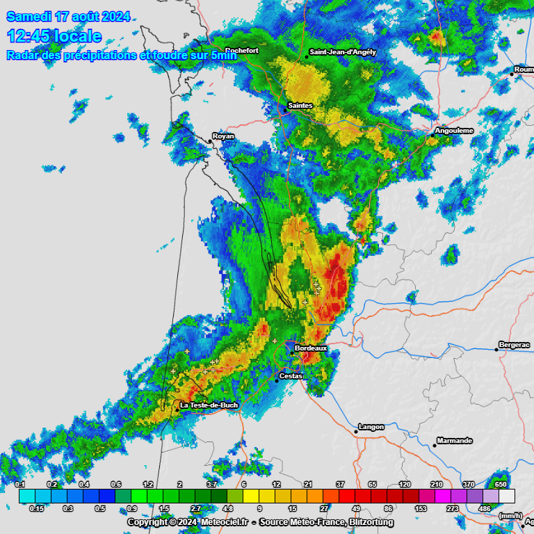
Little storm rn in Bordeaux  |
|
|
|
Post by greysrigging on Aug 18, 2024 3:44:31 GMT -5
As mentioned by cawfeefan, some serious winter heat forecast for Alice Springs... the mean max for August is 22.8c, the forecast max temps for the next 6 days are 7c-12c above the long term average for August.   |
|
|
|
Post by rozenn on Aug 18, 2024 5:13:03 GMT -5
Lots of rain yesterday in the SE suburbs. Up to 76 mm / 3" in Brétigny. Radar-estimated totals:  |
|
|
|
Post by greysrigging on Aug 19, 2024 2:39:58 GMT -5
Bureau of Meteorology: "We don't see fronts like this over Australia every day! The purple line with triangles and semicircles represents an occluded front. It's unusual to see these over Australia, as they usually occur further south. An occluded front occurs when a cold front (blue triangles) overtakes a warm front (red semicircles). The cold air wedges underneath the warm air, forcing the warm air to rise, which can lead to cloud formation and rain along the line of the occluded front. That's why the south coast of Western Australia will see some rain today, before the occluded front weakens and moves into the Bight tomorrow. Today's occluded front is in the shape of a spiral, as it wraps around a low pressure area south of WA. To learn more about the different fronts and how they appear on weather maps, go to ow.ly/LbS650T0N5H"  |
|
|
|
Post by greysrigging on Aug 19, 2024 4:31:29 GMT -5
Record winter warmth heading for Central Australia ( source: Weatherzone )  A spell of warmth is coming to northern parts of the continent which is highly likely to break winter heat records in some places, and the airmass will spread south this weekend, giving southeastern capitals a strong taste of spring. Alice Springs is expected to reach 35°C this Friday and Saturday, and there's every chance that its August record temperature of 35.2°C (which is also the record winter high) could be exceeded. In northern South Australia, Coober Pedy is heading for 33°C on Friday, 34°C on Saturday, and 33°C again on Sunday. Its winter record is 34.3°C. Also in northern SA, Oodnadatta (which holds Australia’s equal-highest recorded temp in any month of 50.7°C) is heading for a pair of 36-degree days on Friday and Saturday. Its winter record, as well as the states winter record, is 36.5°C. A strong, near-stationary high pressure system centred over the heart of the continent this week is the engine that will enable heat to build up in the interior of the country under clear skies. You can see Saturday's expected maximums illustrated in the chart below.  Central Australia is like the oven of Australia. When it heats up, that warmth often spreads to other parts of the continent, and as the high slowly moves into the Tasman Sea later this week, winds circulating anticlockwise around it will push warm air southwards. As mentioned, temps in most southeastern capitals will be exceptionally warm for winter, with an early Sunday forecast of 24°C for Adelaide, 23°C for Melbourne, 21°C for Canberra and 19°C for Hobart. No records are likely to be broken down south due to the influence of a relatively weak cold front clipping the SE corner of the continent, but it will still feel decidedly un-wintry this coming weekend, which is the last full weekend of winter. As for the period beyond this weekend, models show early signs of a strong cold outbreak towards the end of next week, but that's too far in the future to discuss with confidence at this stage. For now, the main item on the meteorological menu is that exceptional Central Australian winter warmth, and we'll keep you up to date with this hot topic as the week progresses. |
|
|
|
Post by jgtheone on Aug 19, 2024 9:15:51 GMT -5
MTD averages here are 7.3C/17.3C. Even with the latest 20-year averages, the anomalies are +0.7C/+2.2C.
Very big anomalies for winter here.
|
|
|
|
Post by greysrigging on Aug 19, 2024 17:46:19 GMT -5
MTD averages here are 7.3C/17.3C. Even with the latest 20-year averages, the anomalies are +0.7C/+2.2C. Very big anomalies for winter here. The August max temp record mean is 17.7c back in 1982. Honourable mention to 1993 ( 17.4c ) and 2011 ( 17.4c ). Melbourne has a chance at setting a new record if the forecast temps in the next 7 days come off. |
|
|
|
Post by greysrigging on Aug 20, 2024 3:14:10 GMT -5
Big winter diurnals in Mt Isa (nw QLD 20.7*S ) the last 6 days....  |
|
|
|
Post by Ethereal on Aug 20, 2024 22:01:37 GMT -5
Gorgeous day in Sydney area:  |
|
|
|
Post by greysrigging on Aug 21, 2024 0:43:48 GMT -5
Outback heat could obliterate winter records in central Australia ( Source: Weatherzone )  An unseasonably warm air mass will challenge winter heat records in central Australia over the coming week, with temperatures set to climb more than 15°C above average for this time of year. A slow-moving ridge of high pressure has allowed hot air to build over northern Australia this week. This hot air mass will start to spread further south over the next few days as northerly winds develop ahead of an approaching low pressure system and associated trough. This air mass is exceptionally hot for this time of year, with temperatures in central Australia predicted to reach levels more typical of mid-summer than winter. The maps below show the predicted maximum temperature on Saturday and how this compares to average temperatures for this time of year. As you can see in the second map, some places in the far north of SA could be more than 15°C warmer than average on Saturday afternoon.   ^^Image: Forecast temperature anomaly at 4pm AEST on Saturday, August 24, according to the GFS model. Source: tropicaltidbits.com According to current forecasts, Saturday’s temperatures could reach 36°C at Coober Pedy and 38°C at Oodnadatta. These places could challenge SA’s current winter heat record of 36.5°C from Oodnadatta on August 12, 1946. In Qld, temperatures are forecast to reach 35 to 37°C around Birdsville and Bedourie between Friday and Sunday. This heat is within a couple of degrees of the state’s winter record, which currently stands at 38.5°C from Bedourie on August 29, 2009. The NT’s winter record of 39.7°C is not likely to be challenged by this week’s heat, although southern parts of the Territory are predicted to reach 35 to 38°C between Thursday and Sunday. Alice Springs is tipped to reach 35°C each day from Friday to Sunday, which could challenge the winter record of 35.2°C at the Airport and the 35.6c from the old Post Office weather station back in 1882. While the highest temperatures over the coming days will occur in central Australia, unseasonably warm air will also waft over the country’s southern and eastern coastlines during the coming week. |
|
|
|
Post by Giorbanguly on Aug 21, 2024 2:17:46 GMT -5
|
|
|
|
Post by aabc123 on Aug 21, 2024 5:28:12 GMT -5
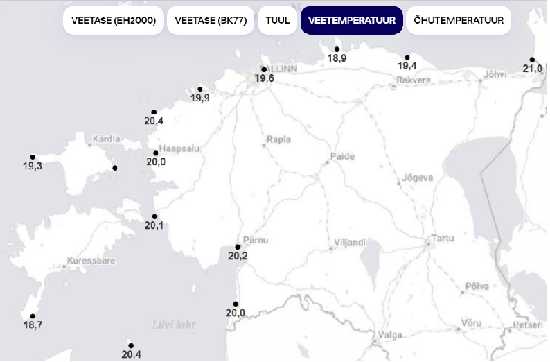
21.8c, partly cloudy, rh 65% at 13:00, low was 12.6c, forecasted high is 24c. The temperature in August has been average, there is still above average precipitation due to heavy rains at the beginning of the month. Sea water temperatures in Estonia right now: ![]()  |
|
|
|
Post by greysrigging on Aug 22, 2024 0:55:44 GMT -5
The hottest max temp in the Australian winter of 2024 happened today at Fitzroy Crossing 38.5c.   |
|
|
|
Post by greysrigging on Aug 22, 2024 4:15:11 GMT -5
Broome has a coupla 39c's in their forecast... be a new August record ( over all the sites ) if it happens... That's a +7.5c above the August mean max.  |
|
|
|
Post by Benfxmth on Aug 22, 2024 8:00:51 GMT -5
|
|