|
|
Post by greysrigging on Aug 22, 2024 18:08:46 GMT -5
If the 41c max temp comes off at Fitzroy Crossing on Monday, it will be very close to breaking the record for the hottest winters day in Australia ( currently 41.2c at West Roebuck in Aug 2020. ) The August record max at Fitzroy Crossing ( dating back to 1955 ) is 39.5c 2020.   Australian records ( max temps ) for August:  |
|
|
|
Post by greysrigging on Aug 23, 2024 1:45:48 GMT -5
Oodnadatta has recorded the hottest winters day in South Australian recorded history with 38.5c ( previous record 36.5c back in 1946 )   |
|
|
|
Post by greysrigging on Aug 23, 2024 3:36:46 GMT -5
|
|
|
|
Post by Beercules on Aug 23, 2024 6:08:57 GMT -5
Hope the New South Wankers enjoy it  |
|
|
|
Post by cawfeefan on Aug 24, 2024 3:57:25 GMT -5
Posting this for posterity - nothing is normal about the forecasted weather for tomorrow   |
|
|
|
Post by Beercules on Aug 24, 2024 5:09:42 GMT -5
I cannot ever recall seeing a forecast use the term "destructive winds". This kind of confidence is NEVER shown by the BOM. It better not be a fizzlah....
|
|
|
|
Post by rozenn on Aug 24, 2024 7:49:08 GMT -5
Lol. Horses ass weather for the usually suspects: London, Brittany, etc. while it's in the mid-30s a few 100s of km away  |
|
|
|
Post by Ethereal on Aug 24, 2024 8:08:09 GMT -5
Nice warm winter day here in Sydney: 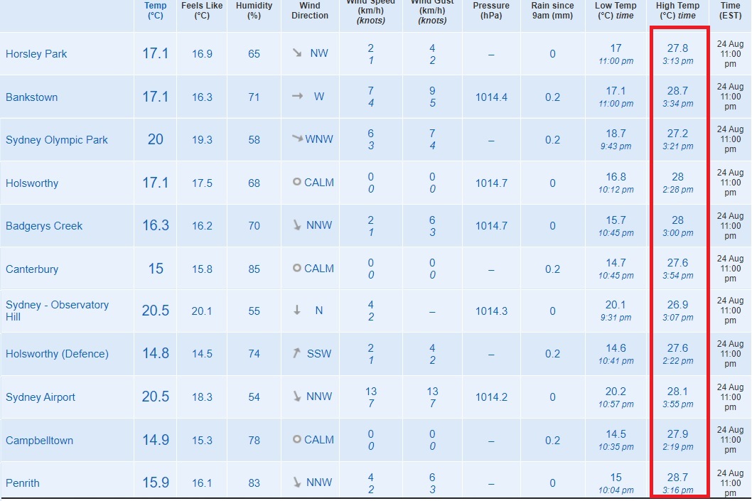 |
|
|
|
Post by rozenn on Aug 24, 2024 11:08:10 GMT -5
Nice. Unexpected precip. Makes sense though with the strong front. 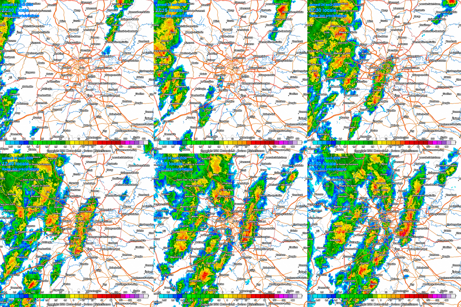 |
|
|
|
Post by Giorbanguly on Aug 25, 2024 4:52:38 GMT -5
Seoul dropped below 25C for the first time in over a month!!!
It dropped all the way to a frigid 24.9C
|
|
|
|
Post by Doña Jimena on Aug 25, 2024 13:19:31 GMT -5
Hot, sunny day, high 31.2C in Riga. Not a heat record here. But still nice, an excellent day for beach. It has also become the second hottest day of the year. The hottest was 28 June with a high of 32.0C in Riga.  |
|
|
|
Post by greysrigging on Aug 25, 2024 15:50:07 GMT -5
Rare winter 40C ends historic weekend of heat in Australia ( source: Weatherzone )  Exceptionally warm August temperatures have pulverised winter heat records in parts of Australia this weekend, with a rare winter 40°C observed in WA on Sunday afternoon. A large pool of abnormally hot air for late winter has been sitting over northern and central Australia during the last few days. While this heat originated over northern Australia, it was dragged across the interior in the last few days by a brisk stream of northwesterly winds, which developed between a high pressure system centred above Qld and a low pressure system centred near the Great Australian Bight. This weather pattern was ideal for abnormally high late-winter temperatures in the Australian interior.  ^^Image: Modelled maximum temperature on Sunday, August 25, according to the ECMWF-HRES model. On Saturday, Oodnadatta registered a maximum temperature of 39.4°C. This was 17°C above average for this time of year and the highest temperature every observed in SA during winter. Prior to this week, SA’s winter heat record was 36.5°C from August 12, 1946. Remarkably, this record was eclipsed four times this week, at Moomba (36.9°C) and Marree (37.3°C) on Saturday and at Oodnadatta on Friday (38.5°C) and Saturday (39.4°C). The final highest reading at Oodnadatta was almost 3°C above the old record, which is a rare margin for a new state maximum temperature record. Another rare temperature seen in Australia this weekend was 40.6°C at Fitzroy Crossing in WA on Sunday afternoon. This was the 3rd highest temperature ever observed in Australia during winter, and only the 5th time an Australian location has exceeded 40°C in winter. In Qld, temperatures rose as high as 38.4°C at Birdsville on Sunday afternoon, which was the second highest winter temperature on record for the state. Minimum temperatures also broke records this weekend. Moomba’s 23.8°C and Oodnadatta’s 23.4°C on Sunday morning both beat the previous SA minimum temperature record of 22.3°C from Oodnadatta on August 23, 1995. Abnormally hot air will linger over northwestern Australia into the start of next week, with potential for more days over 40°C between Monday and Thursday. This hot air will also return to central Australia around Thursday and Friday next week, with temperatures possibly returning to the high-30s once again before winter’s end.  ^^Image: Forecast temperature and wind at 4pm AEST on Friday, August 30. |
|
|
|
Post by greysrigging on Aug 25, 2024 20:13:19 GMT -5
|
|
|
|
Post by Ethereal on Aug 26, 2024 2:19:34 GMT -5
^Oodnadatta was shocking. I more expected such high temps in the NT.
|
|
|
|
Post by Ethereal on Aug 26, 2024 2:22:49 GMT -5
|
|
|
|
Post by greysrigging on Aug 26, 2024 3:09:55 GMT -5
^^ further to Etheral's informative post: A new national heat record for August in Australia with 41.6c recorded at Yampi Sound in WA today. And a new NT heat record for August with a 40c max at Bradshaw ( near Timber Creek ).   Up until yesterday, there had been only 4 temps +40c in August recorded history.... So yesterday was the 5th and 6th such days at Fitzroy Crossing and Kalumburu. Today there were 5 such sites in the Kimberley and the first in the NT for a total of 6 Australia wide +40c !! So 4 such days up until a coupla days ago nationwide and now that total is 12 !! An historic August heatwave in the outback and the deep north...   |
|
|
|
Post by Ethereal on Aug 26, 2024 3:45:24 GMT -5
This all thanks to a Negative SAM phase. Look at how northerly the westerly wind belt is (such events can draw in continental hot weather, particular to the east):  |
|
|
|
Post by Steelernation on Aug 26, 2024 17:56:14 GMT -5
Nice weather in the week I’ve been back in Fort Collins. Building heat to high 80s/low 90s with low dews before clouds move in in the early afternoon, cooling things off. Afternoons have been beautiful with low 80s temps and overcast with nice cloudscapes. Had 2-3 thunderstorms after dark although they’ve mostly been lightning without a lot of thunder. Can’t complain though.
|
|
|
|
Post by Ethereal on Aug 26, 2024 18:42:22 GMT -5
Destructive winds, hundreds of millimitres of rain to impact Tas 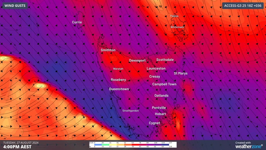 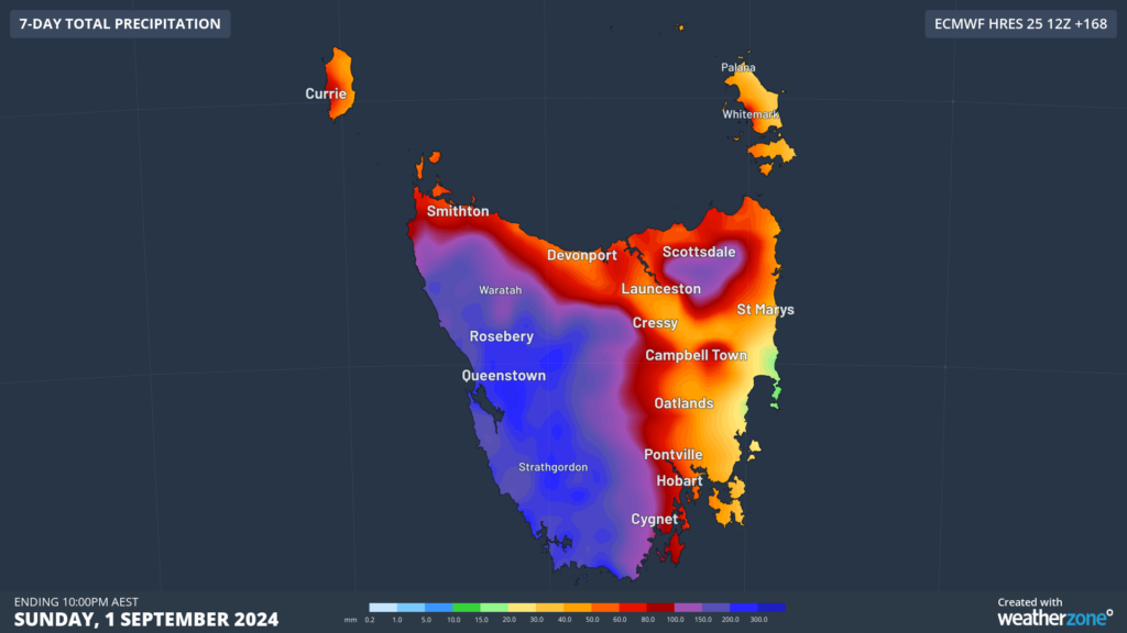 The burst of wet and windy weather will also be accompanied by cold polar airmasses moving over the state this week. The coolest air is set to move over the state on Tuesday evening, with below average temperatures forecast on Wednesday, Thursday and Friday. You can see on the image below that there is a huge contrast in temperatures this week between Tasmania and central parts of Australia, thanks to prevailing westerly winds. 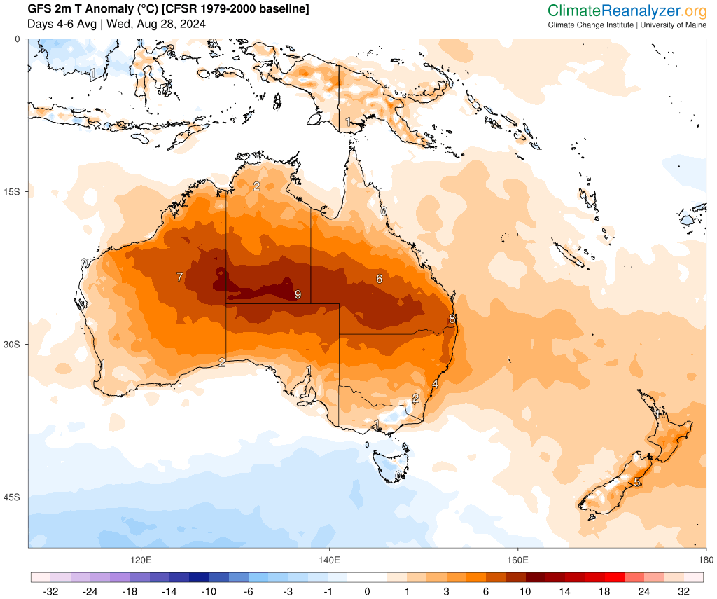 The coldest day looks like Wednesday, with temperatures dropping to freezing on the ranges, while much of rest of the state can expect temperatures between 5 to 12 °C. 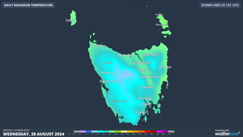 www.weatherzone.com.au/news/destructive-winds-hundreds-of-millimitres-of-rain-to-impact-tas/1889793 www.weatherzone.com.au/news/destructive-winds-hundreds-of-millimitres-of-rain-to-impact-tas/1889793 |
|
|
|
Post by Ethereal on Aug 26, 2024 18:48:06 GMT -5
Really pleasant last week of winter here:  |
|