|
|
Post by greysrigging on Jul 7, 2024 23:31:56 GMT -5
Heaviest July Downpour In A Century For Outback Town ( source: Weatherzone )  Parts of outback SA, NSW and Queensland have received heavy rain over the weekend, with the town of Menindee in far western NSW recording its wettest July day in 138 years. Take a look at the map below, which shows rainfall accumulations in the 24 hours to 9 am Monday. It’s not often you see the highest concentration of green dots (falls of 25 to 49 mm) and orange dots (50 to 99 mm) so far from the coast.  The heavy soaking rain was caused by the interaction between a cut-off upper-level low pressure system and atmospheric moisture flowing from the east, which was given extra fuel by unusually warm sea temperatures. Some of the observations of note to 9 am Monday included: NSW: Inkerman 62 mm: The weather station close to Broken Hill recorded the heaviest reading in the whole of NSW to 9 am Monday. Menindee 48 mm: As stated, this was the heaviest day of July rainfall in 138 years for the outback town with a population of just over 500 people, where the entire monthly average rainfall for July is 17.7 mm. Bourke 41.6 mm: This was the heaviest day of July rainfall in 36 years for the famous outback town on the Darling River, where the entire monthly average rainfall for July is just 14 mm. Wilcannia 41.2 mm: This was the heaviest day of July rainfall in 74 years for the Darling River town about four hours’ drive downstream of Bourke, where the entire monthly average rainfall for July is 18 mm. QLD: Hungerford 54 mm: A weather station in the far SW corner of the state, recorded the state-high total to 9 am Monday. Cunnamulla 28 mm: It was the heaviest July fall for 18 years in the well-known outback outpost. South Australia saw generally lighter falls but several spots well north of Adelaide saw 10 mm or more. As you can see on the three-hour loop to 9 am Monday, the rain continues this morning in many of the areas mentioned, and especially in northwestern NSW around Bourke, although a general drying trend will commence from later today onwards. |
|
|
|
Post by Benfxmth on Jul 8, 2024 6:12:08 GMT -5
First week of Poo-ly is down here, let's review some highlights from that week, might we?
The 1st was a bit of a doozy. Behind the cold front, came ARCTIC STUPIDITY, WITH ICE COLD FUCKEN HURRICANE FORCE NORTHEASTERLIES. Even at 12 PM, it was a mere 72°F with boring ass dry 10 ft thick stratoshit and 60s dews. Guess what the conditions were at midday the previous day (June 30th)? It was 92°F with a 77°F dewpoint with building cumuliform clouds. FUCK THAT SHIT. Early on the 1st, however, I'd get a great lightning show and a solid soaking rain of a total of 0.75", so that was a bit of a compensation, though still, this disgusting cold frontal temp change is IN NO WAY ACCEPTABLE FOR THE MIDDLE OF SUMMER. The pattern transitioned back to a hotter one just in time for 4th of July and onward. Been nowhere near as hot here as the Sandhills (Lumberton had an actual temp of 103°F on the 5th), and of course, almost none of the forecast "storms" per the NWS were nowhere to be seen (except for one cell bringing me 0.63" of rain and some CG lightning on the afternoon of the 6th), though dewpoints reaching epic territory (78-82°F from 5th-7th) made up for the relatively cooler temps. Quick summary at my PWS the first week:  
|
|
|
|
Post by Ariete on Jul 8, 2024 9:38:43 GMT -5
|
|
|
|
Post by Crunch41 on Jul 8, 2024 10:07:54 GMT -5
I'd pick Turku over New Bern honestly. Ariete , you should move to Fair Isle. Must be a pleasant place. |
|
|
|
Post by greysrigging on Jul 8, 2024 19:03:37 GMT -5
Major Antarctic Outbreak From This Weekend ( source: Weatherzone ) There are increasing signs that a prolonged cold snap is on its way to southeastern Australia from Antarctica later this week into next. The frigid air will be dragged from Antarctica by a cold front sweeping across the continent this weekend. A high-pressure system will quickly follow in the fronts path and remain over southern Australia until at least mid-next week, prolonging this cold outbreak. The image below shows the frigid airmass over southeastern Australia early next week, with the southerly winds transporting it north into Qld.  ^^Image: 850 hPa (around 1.5km above the surface) temperature and wind forecast at 10pm AEST on Monday, July 15 The combination of this high pressure system and a low in the Tasman Sea, will direct southerly winds across southeastern Australia. This will keep temperatures 2 to 4°C below average across several states and territories for several days from late this week into next week. These southerly winds will lead to wind chill, with temperatures feeling much colder than the actual temperature. The image below shows southerly wind gusts across southeastern Australia on Tuesday next week.  ^^Image: Instantaneous wind gust forecast at 4pm AEST on Tuesday, July 16, according to ECMWF As the week unfolds, we will update you with more details on the temperatures expected across southeastern Australia later this week into next. |
|
|
|
Post by greysrigging on Jul 8, 2024 19:32:54 GMT -5
A meteorological curiosity ...? 9th of July, so the depths of winter.... And nowhere in Australia recorded a sub zero minimum temperature !! I wonder how often this has happened in July ? Aust lowest: Thredbo Top Station 0.1c NSW/ACT. lowest: Thredbo Top Station 0.1c VIC lowest: Mt Hotham 0.5c QLD lowest: Thargomindah 6.8c WA lowest: Newdegate 3.9c SA lowest: Tarcoola 2.2c TAS lowest: Dover 0.2c NT lowest: Alice Springs 7.1c  |
|
|
|
Post by rozenn on Jul 9, 2024 9:17:50 GMT -5
Short storm rn in Paree. Not really forecasted so nice surprise. The Pyrenees are often visible on a dew point map, like today. They really act like a barrier, everything's generally green north of them and parched south of them.  |
|
|
|
Post by jgtheone on Jul 9, 2024 9:50:42 GMT -5
Pretty chilly first week of July here. Nicer than the apparent record warm winter we were supposed to get.  |
|
|
|
Post by B87 on Jul 9, 2024 10:16:32 GMT -5
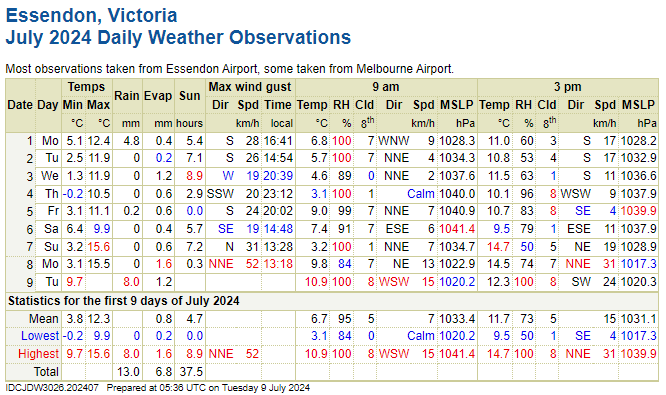
First 9 days of July have been absolutely atrocious. Over 50mm rainfall already, and just 30 hours of sun.
The average high after 9 days is just scraping 20c.
|
|
|
|
Post by cawfeefan on Jul 9, 2024 19:10:38 GMT -5
Pretty chilly first week of July here. Nicer than the apparent record warm winter we were supposed to get.  I overheard someone say the other day “Warmest winter ever? More like coldest winter ever.” Reminds me of what was predicted for last summer, but only Feb was hot. |
|
|
|
Post by jgtheone on Jul 9, 2024 20:48:28 GMT -5
Pretty chilly first week of July here. Nicer than the apparent record warm winter we were supposed to get. I overheard someone say the other day “Warmest winter ever? More like coldest winter ever.” Reminds me of what was predicted for last summer, but only Feb was hot. Fingers crossed the BoM predicts a record cold summer |
|
|
|
Post by rozenn on Jul 10, 2024 0:43:56 GMT -5
Neat skies yesterday   |
|
|
|
Post by MET on Jul 10, 2024 11:50:04 GMT -5
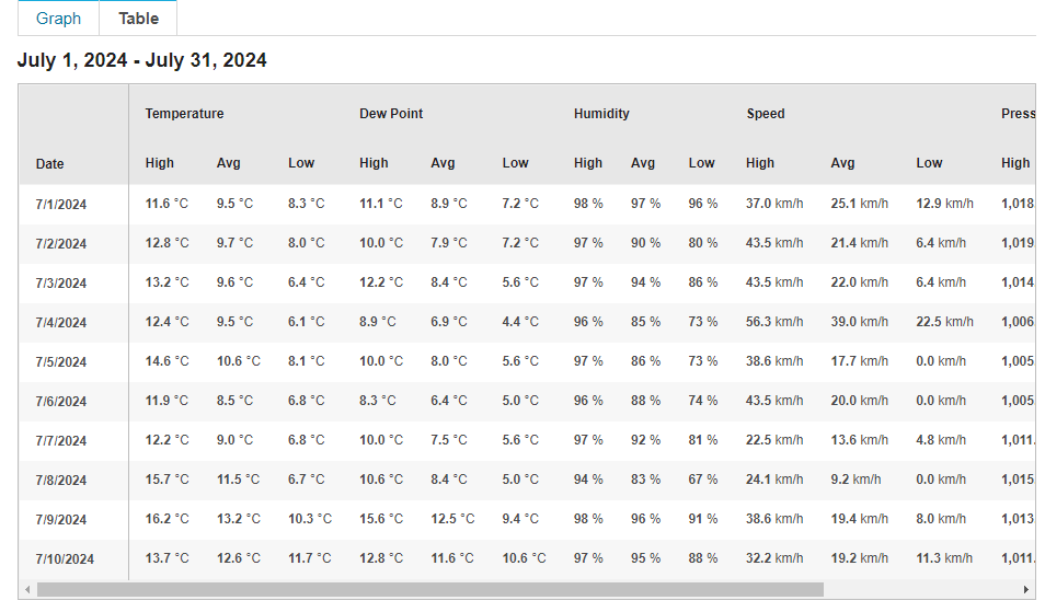
Summer's as dead as a dead dingo's dick, especially for these poorkunts in England's highest village: Check that average max temp for the first 10 days of July, like 13°C or sum shit?  |
|
|
|
Post by rozenn on Jul 10, 2024 12:57:09 GMT -5
Summer's as dead as a dead dingo's dick, especially for these poorkunts in England's highest village: Check that average max temp for the first 10 days of July, like 13°C or sum shit?  Suicidal shit. Why is that place populated? |
|
|
|
Post by MET on Jul 10, 2024 13:00:08 GMT -5
Summer's as dead as a dead dingo's dick, especially for these poorkunts in England's highest village: Check that average max temp for the first 10 days of July, like 13°C or sum shit? Suicidal shit. Why is that place populated? Had summat to do with these religious freaks: en.wikipedia.org/wiki/Wesleyan_theology |
|
|
|
Post by greysrigging on Jul 10, 2024 15:54:13 GMT -5
Snow likely a long way north of the mountains ( source: Weatherzone )  One thing we haven't seen so far this winter in Australia – and which we barely saw through the whole of last winter – is snow in areas beyond the alpine regions of NSW, Victoria and Tasmania. But snow looks highly possible over a period of several days beginning early next week in places like: The Blue Mountains, just west of Sydney The Southern, Central and Northern Tablelands of New South Wales Elevated parts of the ACT, including relatively low hills on the fringe of Canberra and perhaps even parts of the city itself Elevated parts of Victoria outside the Victorian Alps Elevated parts of Tasmania below the mountainous areas And perhaps even in the Granite Belt of southern Queensland The cold air is set to reach southeastern Australia by Saturday, with single-digit maximums likely in all the aqua-blue areas on the map below.  But the coming weather will deliver more than just a day or two of chilly weather. A prolonged outbreak of frigid air with Antarctic origins will envelope southeastern Australia for most of next week from this weekend onwards. Wedged between a strong high pressure system centred over the Bight and a low in the Tasman Sea, this lingering, bitterly cold airmass will make it feel like someone left the fridge door open for several days. It will be cold, even for July: that much we can guarantee. What remains uncertain at this stage is how much moisture will be associated with system, and when it will arrive.  Weatherzone meteorologist Felix Levesque says the NSW Central Tablelands could see snow flurries at higher levels around 12000m as early as Sunday night/Monday morning, with the possibility of snow increasing throughout Monday and Tuesday as more moisture arrives. The snow level could drop below 1000m midweek as a new influx of moisture kicks in. Snow around midweek is also quite likely in the Barrington Tops just northwest of Newcastle, which rise to almost 1600m at their highest point. The Northern Tablelands should also get their share, including the town of Guyra, which at 1330m is Australia's highest town outside the alpine region.  ^^Image: Daisy and her friends were not particularly impressed with this 2021 snowfall near Oberon, on the NSW Central Tablelands. Source: @duckmaloi_river_truffles on Instagram. Further south, the snow line on the mainland will drop to 600 or 700 metres by midweek. Most of Canberra lies at or just below 600 metres, so snow in the city itself is not out of the question. Victoria will also see snowfalls at times in places beyond the mountains that rarely see a settled cover, while in Tasmania the snowline should be about 700 metres. It's not often with a winter cold outbreak that the snowline in Tasmania is similar to areas more than a thousand kilometres north, but both the northward push and duration of the coming cold airmass promise to be quite remarkable. As for the ski resorts, this system can only be good news. Snow cover beyond the snowmaking slopes is currently thin at the higher Australian resorts and non-existent at lower resorts. Likely snowfall totals for the resorts are difficult to predict with this system, but the midweek period looks best for significant falls. At the very least, they should be able to fire up the snow guns all week. We'll keep you posted, and as ever, check our snow page for the latest forecasts, snow cam images and more. |
|
|
|
Post by psychedamike24 on Jul 10, 2024 22:15:02 GMT -5
|
|
|
|
Post by jgtheone on Jul 10, 2024 22:30:02 GMT -5
Snow likely a long way north of the mountains ( source: Weatherzone )  One thing we haven't seen so far this winter in Australia – and which we barely saw through the whole of last winter – is snow in areas beyond the alpine regions of NSW, Victoria and Tasmania. But snow looks highly possible over a period of several days beginning early next week in places like: The Blue Mountains, just west of Sydney The Southern, Central and Northern Tablelands of New South Wales Elevated parts of the ACT, including relatively low hills on the fringe of Canberra and perhaps even parts of the city itself Elevated parts of Victoria outside the Victorian Alps Elevated parts of Tasmania below the mountainous areas And perhaps even in the Granite Belt of southern Queensland The cold air is set to reach southeastern Australia by Saturday, with single-digit maximums likely in all the aqua-blue areas on the map below.  But the coming weather will deliver more than just a day or two of chilly weather. A prolonged outbreak of frigid air with Antarctic origins will envelope southeastern Australia for most of next week from this weekend onwards. Wedged between a strong high pressure system centred over the Bight and a low in the Tasman Sea, this lingering, bitterly cold airmass will make it feel like someone left the fridge door open for several days. It will be cold, even for July: that much we can guarantee. What remains uncertain at this stage is how much moisture will be associated with system, and when it will arrive.  Weatherzone meteorologist Felix Levesque says the NSW Central Tablelands could see snow flurries at higher levels around 12000m as early as Sunday night/Monday morning, with the possibility of snow increasing throughout Monday and Tuesday as more moisture arrives. The snow level could drop below 1000m midweek as a new influx of moisture kicks in. Snow around midweek is also quite likely in the Barrington Tops just northwest of Newcastle, which rise to almost 1600m at their highest point. The Northern Tablelands should also get their share, including the town of Guyra, which at 1330m is Australia's highest town outside the alpine region.  ^^Image: Daisy and her friends were not particularly impressed with this 2021 snowfall near Oberon, on the NSW Central Tablelands. Source: @duckmaloi_river_truffles on Instagram. Further south, the snow line on the mainland will drop to 600 or 700 metres by midweek. Most of Canberra lies at or just below 600 metres, so snow in the city itself is not out of the question. Victoria will also see snowfalls at times in places beyond the mountains that rarely see a settled cover, while in Tasmania the snowline should be about 700 metres. It's not often with a winter cold outbreak that the snowline in Tasmania is similar to areas more than a thousand kilometres north, but both the northward push and duration of the coming cold airmass promise to be quite remarkable. As for the ski resorts, this system can only be good news. Snow cover beyond the snowmaking slopes is currently thin at the higher Australian resorts and non-existent at lower resorts. Likely snowfall totals for the resorts are difficult to predict with this system, but the midweek period looks best for significant falls. At the very least, they should be able to fire up the snow guns all week. We'll keep you posted, and as ever, check our snow page for the latest forecasts, snow cam images and more. The way this is written they are REALLY unsure haha. They're definitely scared of a bust. Checking the models though I can see why, it's rapidly changing day by day especially in terms of rainfall. All we know is that it's going to be cold. |
|
|
|
Post by greysrigging on Jul 11, 2024 0:05:21 GMT -5
^^ I think the issue is the amount of moisture within the systems... it's gunna be cold for sure, but snowfalls might be problematic if its a dry cold.
|
|
|
|
Post by Ethereal on Jul 11, 2024 2:03:27 GMT -5
Snow likely a long way north of the mountains ( source: Weatherzone ) But the coming weather will deliver more than just a day or two of chilly weather. A prolonged outbreak of frigid air with Antarctic origins will envelope southeastern Australia for most of next week from this weekend onwards. Wedged between a strong high pressure system centred over the Bight and a low in the Tasman Sea, this lingering, bitterly cold airmass will make it feel like someone left the fridge door open for several days. It will be cold, even for July: that much we can guarantee. What remains uncertain at this stage is how much moisture will be associated with system, and when it will arrive.  So glad that Sydney and surrounds are rain-shadowed here -- The airflow from the low will come from the southwest, thus saving us from cool rain days, and not the immediate south (this S-SE travesty has been occurring since flippin' April here due to persistent highs in the Southern Ocean). Let's hope they don't get this prediction wrong! I miss these sweet dry, winter westerlies...Damn! |
|


