|
|
Post by MET on Jul 11, 2024 12:09:40 GMT -5
Well then... think I'll be off to northern Iceland to suntan my six pack. 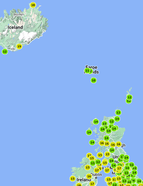 |
|
|
|
Post by Benfxmth on Jul 11, 2024 19:03:32 GMT -5
NWS forecasted storms here today yet again, yet nothing happened of course, the frontal convergence boundary stayed west of here all this time. Incredible how the worthless work experience fаggots didn't bother to pinpoint the location of it even with hi-res model guidance available and generalize instead.
On the other hand however, given no precip cooling, I'd almost end up with an 80°F low, been 90.7/79.7°F daily high/low at my PWS today.
EDIT: midnight-midnight daily low yesterday ended up being 78.2°F, due to weak outflow/precip cooling from an isolated thundershower late evening
|
|
|
|
Post by jgtheone on Jul 11, 2024 23:20:15 GMT -5
|
|
|
|
Post by Ethereal on Jul 12, 2024 2:41:31 GMT -5
^An amazing thing for sure (if their prediction comes true). This means more sunny, relatively warm weather for the leeside of the Great Dividing Range. And no more of these dreaded Bight Highs that give us polar cloudy crap! A some sort of 'Deus Ex Machina' for the final months of this horrible winter, really! Anyways here's the news story of the event (or phenomena): Sudden stratospheric warming event underway – here's what it means for Australian weather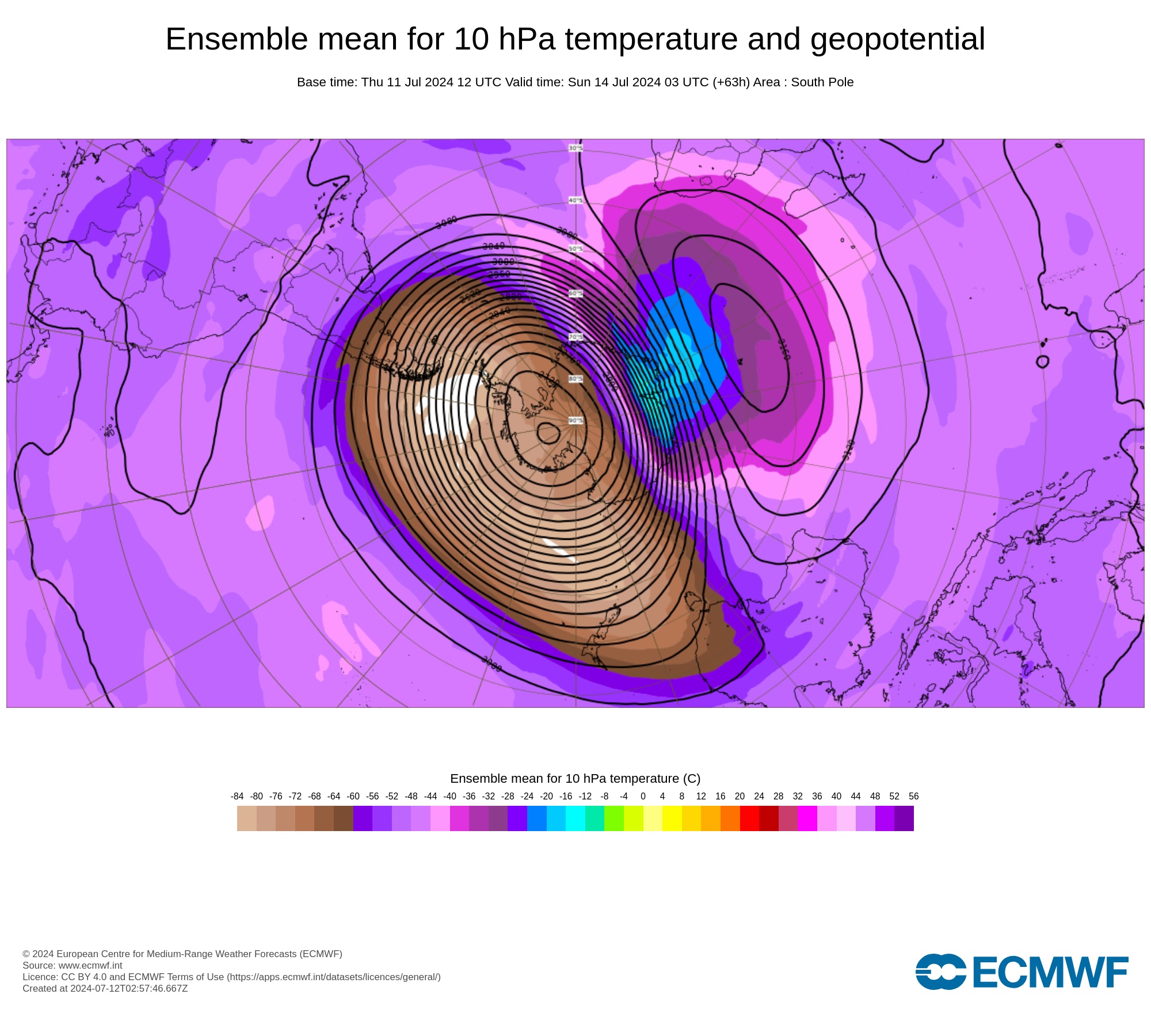 A rare sudden stratospheric warming event is beginning to occur above Antarctica, and it may influence Australia’s weather in the coming weeks. The term sudden stratospheric warming (SSW) refers to an abrupt increase in air temperature high above either of Earth’s polar regions, typically on the magnitude of tens of degrees Celsius in a few days. This warming occurs in a layer of the atmosphere called the stratosphere, roughly 30 to 40km above the surface. A rare sudden stratospheric warming event is beginning to occur above Antarctica, and it may influence Australia’s weather in the coming weeks. The term sudden stratospheric warming (SSW) refers to an abrupt increase in air temperature high above either of Earth’s polar regions, typically on the magnitude of tens of degrees Celsius in a few days. This warming occurs in a layer of the atmosphere called the stratosphere, roughly 30 to 40km above the surface.
While warming in the stratosphere does not immediately (or always) affect weather patterns near the ground, SSW events can filter down through the atmosphere and influence tropospheric weather in the weeks following the initial SSW. If an SSW event does make its way down to the troposphere, it can cause the tropospheric polar vortex to weaken, which allows cold polar air to drift further away from Antarctica (or the Arctic if in the Northern Hemisphere) and spread towards the mid-latitudes.
Through this domino effect, SSW events can cause the Southern Annular Mode (SAM) to shift into a negative phase, which can have the following impacts in Australia during winter:
- More cold fronts and low pressure systems over southern Australia
- Increased rainfall and snow potential in southwest and southeast Australia
- Reduced rainfall in parts of eastern Australia
- Stronger winds in the southern half of Australia
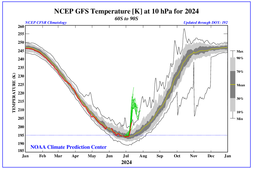
Warming has been detected in the stratosphere above the Antarctic region over the past week, revealing that an SSW event is starting to occur in the Southern Hemisphere. Some forecast models predict that this stratospheric warming will continue over the next week and start to filter down through the atmosphere later this month. The graph below shows observed stratospheric temperatures in red and the forecast from one model in green. From these lines you can see a sudden increase in the temperature beyond the normal range, potentially getting even warmer than any other observed event at this time of year.
 It is currently unclear whether the stratospheric warming will influence weather closer to the ground in the coming weeks. However, some models are already showing signs that the SSW signal will descend to lower altitudes during the second half of July. If this trend continues, it will increase the likelihood of a shift towards a negative SAM in late July or August. It is currently unclear whether the stratospheric warming will influence weather closer to the ground in the coming weeks. However, some models are already showing signs that the SSW signal will descend to lower altitudes during the second half of July. If this trend continues, it will increase the likelihood of a shift towards a negative SAM in late July or August.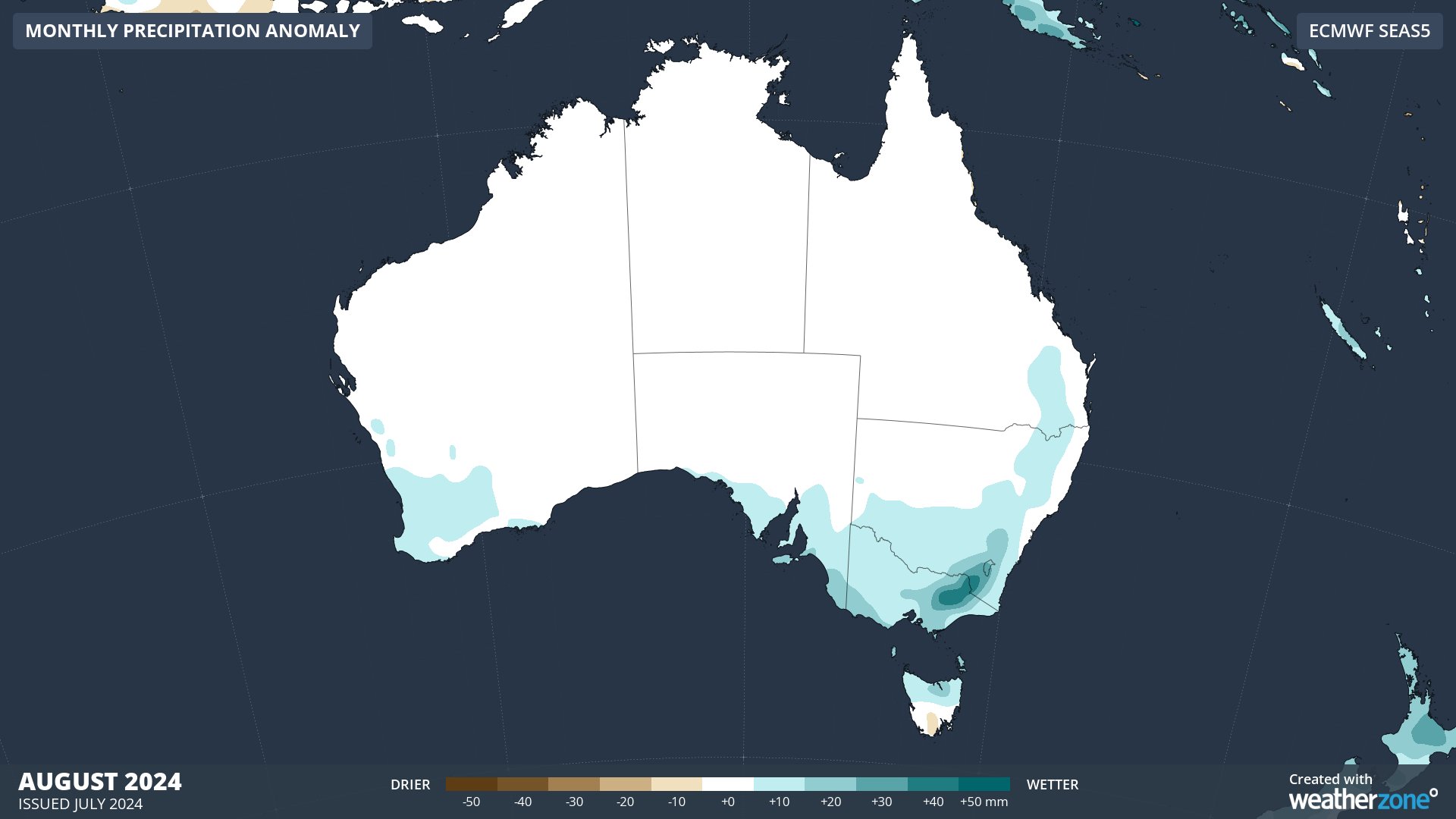 Only a few SSW events have been observed in the Southern Hemisphere, with the most recent one occurring in 2019. Only a few SSW events have been observed in the Southern Hemisphere, with the most recent one occurring in 2019. |
|
|
|
Post by Beercules on Jul 12, 2024 3:03:43 GMT -5
Sounds like rabies.
|
|
|
|
Post by greysrigging on Jul 12, 2024 3:05:41 GMT -5
At last, snow coming to ski resorts ( source: Weatherzone )  Much-needed snowfalls are coming to Australia's ski resorts – the question is how much? We've written several times this week about the strong cold airmass with Antarctic origins which is tracking towards southeastern Australia from this weekend onwards. The airmass will linger for an unusually long period, and will be cold enough for snow in elevated areas well beyond the mountains.  ^^Image: As you can see on this BoM Meteye chart for Monday July 15 where purple blotches, mean snow, flakes are expected right up to the NSW Northern Tablelands. Source: BoM. How much will fall on ski slopes where it's really needed? The short answer is that 25 to 50 cm should fall at most resorts between about Saturday and Thursday. We could even get lucky and see heavier falls. But the bottom line is that snowfall totals from weather systems like this are not easy to predict. In winter, we tend to look for moisture-laden cold fronts crossing the Great Australian Bight that surge northwards, delivering snow across the alpine areas of the southeast. This system is a little different. While a front will approach on Saturday with the chance of a few associated snow flurries, there won't be much moisture accompanying the initial temperature drop. The main action kicks off later on Sunday into the working week, as a ferocious low pressure system forms in the Tasman Sea. With a broad pool of cold air lingering over the southeast, this low has the potential to funnel large amounts of moisture over the mountains.  But it will likely be hit and miss – as these systems tend to be. Some resorts might be lucky to see more than a few centimetres. Others could get a dump they talk about for years. There is also the potential for some dramatic temperature fluctuations early next week as the low brings in warmer air from the Tasman Sea. At times, we could see an atmospheric battle between frigid air over the mainland and mild maritime air, with the snow level dropping and rising accordingly. The resort where things look really exciting is Mt Baw Baw, the closest ski hill to Melbourne and Australia's lowest resort, topping out at just 1550m. Poor old Baw Baw has done it tough in recent years and there's strong evidence of declining snowfall as the climate has warmed. But occasionally, the weather gods still conspire up to deliver huge totals to Baw Baw. That usually happens in a strong southerly or – as will be the case next week – when a low is positioned in just the right spot off the East Gippsland coast. Tasmania's only commercial ski resort, Ben Lomond near Launceston, is also in line for its first significant snowfalls of the 2024 winter. At present, its barely skiable snow cover is entirely machine-made.  For the main NSW and Victorian resorts including Perisher, Thredbo Charlotte Pass, Selwyn, Mt Hotham, Falls Creek and Mt Buller, the signs are promising. But for now, it’s a matter of wait and see what Monday brings. The good news is that this system has opened the door (so to speak) for further snowy systems, with good pointers to snow-bearing cold fronts peaking in eastern Australia in the coming two-week period. As ever, keep checking our snow page for the latest forecasts, snow cams, and more. |
|
|
|
Post by Steelernation on Jul 12, 2024 21:22:08 GMT -5
The Fort Collins AgMet station had a high of 102.7 (39.3 c) today, which rounds to 103, tying the all time record high.
The hottest 5-minute observation of 102.5 was slightly hotter than the hottest 5-minute observation from the 2005 record holder (101.9 f). So very likely today was slightly higher even if both round to 103.
Of course, the official data for the coop station hasn’t come in yet, occasionally1 f off from the AgMet station. So no official record yet.
Meanwhile, Las Vegas beat its previous all time record 4 times between the 7th-11th. Had never gotten past 117 in 86 years of data and then had highs of 120, 119, 118, and 118 in a five day stretch.
|
|
|
|
Post by Steelernation on Jul 13, 2024 8:50:52 GMT -5
Ok never mind, 102 (39 c) at the coop station. Impressively hot but doesn’t tie the record high. Supposed to be in the 100s today and tomorrow though so two more chances.
Meanwhile in Minnesota, there’s a singular 88 f forecast today. Pathetic that it’s mid July and this is the most interesting temp I’ve seen. Right back down to the boring 70s/low 80s after today too.
|
|
|
|
Post by aabc123 on Jul 13, 2024 12:53:11 GMT -5
13/07
High 25.9c, low 13.8c, sun and clouds, mostly cloudy in the afternoon, it is likely to rain tonight.
|
|
|
|
Post by irlinit on Jul 13, 2024 14:59:58 GMT -5
Yeah... FUCK this country, fuck this piece of shit latitude that constantly seems to get the short straw. You couldn't put this chart any more perfectly slap bang over the UK.  |
|
|
|
Post by rozenn on Jul 13, 2024 15:53:23 GMT -5
Dammit dozens of mm just north of me today, nil here   |
|
|
|
Post by Beercules on Jul 13, 2024 16:18:05 GMT -5
Yeah... FUCK this country, fuck this piece of shit latitude that constantly seems to get the short straw. You couldn't put this chart any more perfectly slap bang over the UK. Bet you want to dispatch that gaybo anti-intelligence anomoly southathens more than anyone here... |
|
|
|
Post by irlinit on Jul 13, 2024 16:37:53 GMT -5
Yeah... FUCK this country, fuck this piece of shit latitude that constantly seems to get the short straw. You couldn't put this chart any more perfectly slap bang over the UK. Bet you want to dispatch that gaybo anti-intelligence anomoly southathens more than anyone here... It's fucking annoying. Who needs a month of 40c+ when your average is already low to mid 30s.. stealing all the heat unnecessarily when summers there are already perfect and reliably hot and sunny. Meanwhile it's mid July and I drove past a pub with smoke coming out of the chimney - yes they are having to heat the interior inside due to this constant low pressure stratocrapulus shit |
|
|
|
Post by Beercules on Jul 13, 2024 19:51:53 GMT -5
Bet you want to dispatch that gaybo anti-intelligence anomoly southathens more than anyone here... It's fucking annoying. Who needs a month of 40c+ when your average is already low to mid 30s.. stealing all the heat unnecessarily when summers there are already perfect and reliably hot and sunny. Meanwhile it's mid July and I drove past a pub with smoke coming out of the chimney - yes they are having to heat the interior inside due to this constant low pressure stratocrapulus shit That's exactly what has me seeing red.... already hot places the world over getting record heat year upon year, while we can't even string together 2 weeks of above avg temps in the whole crummer.    |
|
|
|
Post by Cheeseman on Jul 13, 2024 21:38:43 GMT -5
I'm surprised there's been no discussion about Hurricane Beryl, which became the earliest Category 5 Atlantic hurricane on record on July 1 and made landfall in Grenada, southeast Mexico, and Texas.  I got a little bit of cloud cover from Beryl's remnants this past Wednesday (July 10) but no rain. 40 fatalities have been confirmed so far. |
|
|
|
Post by Ethereal on Jul 14, 2024 0:46:01 GMT -5
Interesting little foehn effect/rain shadow effect in the southeast right now:   |
|
|
|
Post by Ethereal on Jul 14, 2024 3:15:14 GMT -5
Two low pressure systems spinning in the Tasman Sea have their arm-like fronts stretching across the Tasman, making it appear like they're giving one another a high-five. After the blistering cold weather they brought to Australia's east coast, our neighbours in New Zealand will also have a strong taste of winter. The southern low is heading for Tasmania on Sunday, warranting the Bureau of Meteorology's damaging wind warning along the east and west coasts, exposed islands (such as King Island) and the elevated centre. 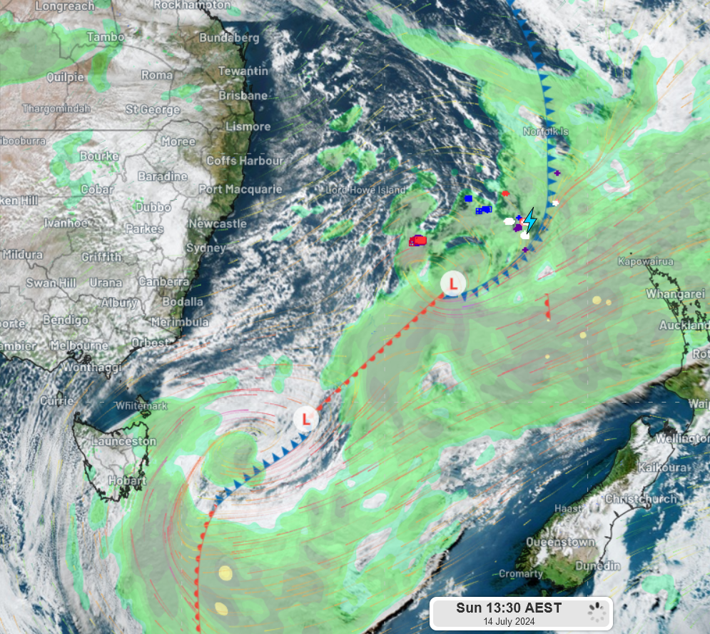 ...Blistering cold in the mountains but pleasant here on the coastline. These snowbearing low pressure systems in the south are more forgiving to Sydneysiders/the eastern seaboard than the fucking "calm" highs in the Bight that give us cloud, chilly rain crap from the south. This is also a win-win situation for the snow lovers in the Ranges. So bring on such systems, but stay south and away from Sydney. Mornings were cold though: 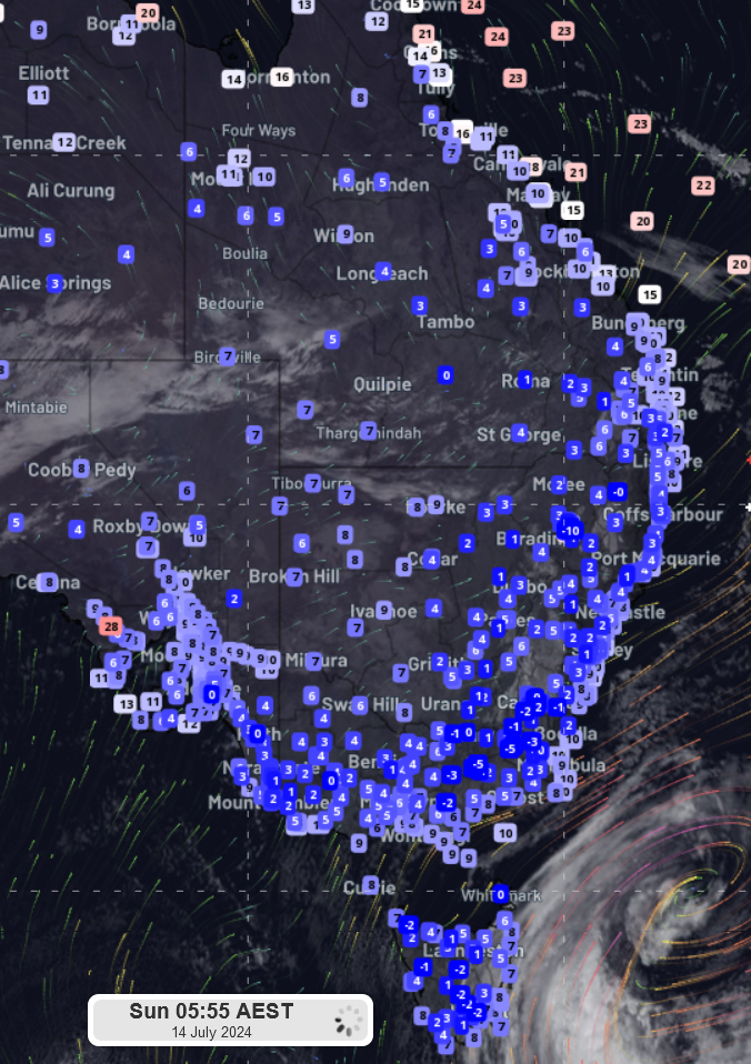 www.weatherzone.com.au/news/double-or-nothing/1889637 www.weatherzone.com.au/news/double-or-nothing/1889637
|
|
|
|
Post by desiccatedi85 on Jul 14, 2024 8:18:05 GMT -5
Entering what is probable to be the hottest stretch of the year here, with multiple 100ºF+ days forecast. Half of summers don't even see one such day, and the average summer absolute maximum is 99ºF, but it's already hit 100ºF once in June and likely to do so a couple more times here this week 
No particularly anomalous high pressure ridge in place, different to the setup in the June heatwave. Rather, now just a very warm airmass along with a westerly flow. 850mb temp anomalies of 7-10ºC above average expected.
|
|
|
|
Post by MET on Jul 14, 2024 8:30:13 GMT -5
What a lovely, warm afternoon it's turning out to be. In North-East Iceland I mean. Only some 10°C higher than Shitfield et al.  |
|
|
|
Post by irlinit on Jul 14, 2024 11:53:53 GMT -5
What a lovely, warm afternoon it's turning out to be. In North-East Iceland I mean. Only some 10°C higher than Shitfield et al.  Shoot me in the head and cut off my balls |
|