|
|
Post by greysrigging on Jul 31, 2024 4:55:36 GMT -5
July is the 'depths of winter' in the Top End... also in the southern NT and its all over red rover for another 12 months... we now see the gradual warming/heat of the impending 'build up' season. Darwin had its wettest July since 2001 with 2.4mm rain over 2 days on Darwin Show weekend. and the first July rain since 2010 ! The median for July is 0.0mm... We had 17 days sub 20c mins for the month at the Airport, with the coldest min dipping to 14.8c... but even so we ended up +0.7c re mins for the montn. And +0.6c for max temps despite 6 sub 30c max temps. Alice Springs July in 2024 pretty well normal re long term means... 9 sub zero mins and 18 sub 20c max temps so -1.0c for mins and -0.1c for max temps. And 'dry July' rainfall with only 3.2mm falling. The central parts of the NT and southern Top End had a bit of a north west cloud band that delivered full on cloudy and overcast conditions but only a few isolated showers. The far north east tip of the NT had their usual light coastal showers throughout July with 6.8mm over 7 days at Gove Airport and 5.6mm at Cape Wessel. Bradshaw ( a former cattle station that is now a military training ground south west of Darwin ) recorded 36.1c on the 1st of the month and Watarrka ( near Alice Springs ) apparently recorded a -5.8c on the 2nd of the month, but this is likely going to be disputed as a faulty AWS reading.   Rainfall - 2.4mm rainfall ( long term mean 1.1mm, median 0.0mm ) Highest daily fall - 2.2mm Max temps - 31.3c av ( long term mean 30.7c ) Highest max 33.8c on the 10th. Lowest max 26.9c on the 10th Min temps - 20.0c av ( long term mean 19.3c ) Highest min 24.9c on the 7th. Lowest min 14.8c on the 18th.    Rainfall - 2.4mm falling on 2 days ( long term mean 14.0mm) Highest daily fall 2.4mm Max temps - 19.8c av ( long term mean 19.9c) Highest max 28.5c on the 11th. Lowest max 12.7c on the 2nd Min temps - 3.0c av ( long term mean 4.0c ) Highest min 11.3c on the 12th. Lowest min -3.1c on the 30th.   |
|
|
|
Post by B87 on Jul 31, 2024 12:59:01 GMT -5
July 2024 was slightly cooler, slightly cloudier and much wetter than average. Full stats tomorrow.
|
|
|
|
Post by 🖕🏿Mörön🖕🏿 on Jul 31, 2024 15:28:11 GMT -5
Glorious month. Only two thunderstorm days but that's fine. Only three significant rain days. The other ten days were hardly anything. It'll be interesting to see how different August is. I would be very surprised if August was a continuation of July.  |
|
|
|
Post by MET on Jul 31, 2024 18:15:54 GMT -5
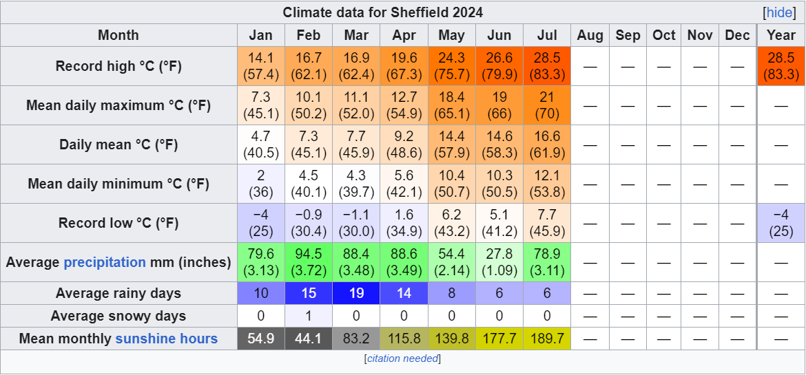
JULY 2024 SUMMARY IN BEIGHTON, SOUTH YORKSHIRE
Records from Sheffield, South Yorkshire
July 2024 started with slightly below average temperatures and lower than average pressure. The polar jetstream was located over or slightly below the UK leading to regular rainfall in this period. The rainy and cooler than average conditions lasted until 15th. After this, the conditions became warmer as the jetstream tended northwards. This lead to a dry and warm second half to the month. It was also quite hot on a number of days; such as 18th-19th, and 28th-31st. After the slow warm-up and exceptional gloom of the first half, the month matured into a more typical summer month, and the temperature averaged at 0.5°C below normal. The rain was above average, but because most of it fell in one day, it felt like a dry month with only 6 days recording 1mm rainfall or more. The month had no thunderstorms, the closest it got was a weak thunderstorm over Sheffield on 9th, but that turned into a blunderstorm on arrival at my location, and it wasn't possible to hear thunder; at least not clearly, so whatever sounds I may have heard were indistinct enough that it could have been a wheelie bin being moved. So no thunderstorms were recorded during the month, which is usually the most stormy of the year with an average of two thunder days.

|
|
|
|
Post by Cadeau on Jul 31, 2024 20:17:31 GMT -5
I have visited Tokyo & Yokohama between 4~9 July. My personal monthly record high holds in Paris by 0.2°C.
Volatile weather in the past week but overall very average month in Paris. (+0.1°C high, +0.0°C low, +0.1°C mean, 121% of precipitation, 92% of sunshine from normal)Paris, Île-de-France, France July 2024 Average: High 25.8°C / Low 16.2°C / Mean 21.0°CHighest: 36.2°C [30th] Lowest: 11.1°C [7th] Lowest High: 19.0°C [27th] Highest Low: 21.3°C [31st] Precipitation: 72.1 mmPrecipitation Days: 12 Sunshine Hours: 204 hours 18 minutes Sunshine Percentage: 42.2% Early July: High 23.5°C / Low 14.8°C / Mean 19.1°C / Precipitation 11.0 mm / 57:41 sunshine hours Mid July: High 26.6°C / Low 16.0°C / Mean 21.3°C / Precipitation 23.6 mm / 76:44 sunshine hours Late July: High 27.0°C / Low 17.7°C / Mean 22.4°C / Precipitation 37.5 mm / 69:53 sunshine hours   - Seoul, South Korea July 2024 Average: High 29.6°C / Low 24.1°C / Mean 26.6°CHighest: 33.3°C [13th,31st] Lowest: 21.3°C [5th] Lowest High: 24.5°C [8th] Highest Low: 27.5°C [27th] Precipitation: 557.3 mmPrecipitation Days: 18 Snowfall: 0.0 cm Snowy Days: 0 Average Relative Humidity: 81.0% Average Wind Speed: 2.5 m/s Sunshine Hours: 96.3 hours Sunshine Percentage: 21.5% Early July: High 28.0°C / Low 22.4°C / Mean 24.9°C / Precipitation 127.9 mm / 21.6 sunshine hours Mid July: High 30.2°C / Low 23.9°C / Mean 26.7°C / Precipitation 260.0 mm / 46.0 sunshine hours Late July: High 30.7°C / Low 25.8°C / Mean 28.1°C / Precipitation 169.4 mm / 28.7 sunshine hours   - Tokyo, Japan July 2024 Average: High 33.5°C / Low 25.0°C / Mean 28.7°CHighest: 37.3°C [29th] Lowest: 22.1°C [17th] Lowest High: 26.9°C [12th] Highest Low: 29.3°C [29th] Precipitation: 206.5 mmPrecipitation Days: 10 Snowfall: 0 cm Snowy Days: 0 Average Relative Humidity: 78% Average Wind Speed: 2.6 m/s Sunshine Hours: 199.6 hours Sunshine Percentage: 45.1% Early July: High 33.7°C / Low 25.1°C / Mean 28.8°C / Precipitation 48.5 mm / 71.2 sunshine hours Mid July: High 30.7°C / Low 23.8°C / Mean 26.7°C / Precipitation 84.5 mm / 33.6 sunshine hours Late July: High 35.8°C / Low 26.0°C / Mean 30.4°C / Precipitation 73.5 mm / 94.8 sunshine hours   *Note: The warmest July since record began in 1875. (1st of 150 years) Tied the 2023 record. *Note: The warmest July since record began in 1875. (1st of 150 years) Tied the 2023 record.
Though technically 2nd place. (July 2023 sum in averages: 890.0 / July 2024 sum in averages: 889.4)| Rank | Mean Temp | Year | | 1st | 28.7°C | 2023,2024 | | 3rd | 28.5°C
| 2001,2004 | | 5th | 28.3°C | 1994,2018 | | 7th | 28.0°C
| 2002,2010 | | 9th | 27.8°C
| 1978 | | 10th | 27.7°C | 2000 |
|
|
|
|
Post by tommyFL on Jul 31, 2024 23:24:19 GMT -5
July 2024 SummaryMuch-warmer than normal (+1.3 °F/+0.7 °C/95th percentile) and much drier than normal (52% of average precipitation/10th percentile)Boring hot and dry month that was the warmest since I started making observations back in 2021    Highest daily max temp: 96.7 °F (35.9 °C) on the 8th Mean daily max temp: 92.3 °F (33.5 °C)Lowest daily max temp: 82.9 °F (28.3 °C) on the 11th Highest daily mean temp: 85.9 °F (29.9 °C) on the 8th Mean temp: 82.0 °F (27.8 °C)Lowest daily mean temp: 77.7 °F (25.4 °C) on the 11th Highest daily min temp: 78.2 °F (25.7 °C) on the 9th Mean daily min temp: 75.5 °F (24.2 °C)Lowest daily min temp: 71.2 °F (21.8 °C) on the 10th Highest diurnal range: 22.3 °F (12.7 °C) on the 7th Mean diurnal range: 16.8 °F (9.3 °C)Lowest diurnal range: 9.8 °F (5.4 °C) on the 11th Precipitation: 4.43" (112.4 mm)Number of days with precipitation ≥ 0.01" (0.3 mm): 12 daysHighest daily precipitation: 1.63" (41.4 mm) on the 28th Highest instantaneous precipitation rate: 9.07"/hr (230.4 mm/hr) on the 28th Duration of measurable precipitation: 20.6 hours (2.9% of the month)Highest temp with measurable precipitation: 86.2 °F (30.1 °C) on the 20th Mean temp of measurable precipitation: 76.9 °F (24.9 °C)Lowest temp with measurable precipitation: 71.4 °F (21.9 °C) on the 10th Highest relative humidity: 100% on 10 days Mean daily max relative humidity: 99.0%Highest daily mean relative humidity: 95.7% on the 31st Mean relative humidity: 86.0% Lowest daily mean relative humidity: 77.7% on the 6th Mean daily min relative humidity: 61.8%Lowest relative humidity: 47% on the 17th Highest dew point: 82.5 °F (28.1 °C) on the 3rd Mean daily max dew point: 80.5 °F (26.9 °C)Highest daily mean dew point: 78.4 °F (25.8 °C) on the 3rd and 31st Mean dew point: 77.0 °F (25.0 °C)Lowest daily mean dew point: 73.7 °F (23.2 °C) on the 6th Mean daily min dew point: 73.9 °F (23.3 °C)Lowest dew point: 69.9 °F (21.1 °C) on the 10th Highest barometric pressure: 30.20 inHg (1023 mbar) on the 13th, 24th, and 25th Mean barometric pressure: 30.05 inHg (1018 mbar)Lowest barometric pressure: 29.89 inHg (1012 mbar) on the 5th Largest 1-day mean temp rise: 5.3 °F (2.9 °C) between the 23rd and 24th Largest 1-day mean temp drop: 3.7 °F (2.1 °C) between the 9th and 10th Mean daily variability (average difference in mean temp between consecutive days): 1.6 °F (0.9 °C)Observations are from 12 AM to 12 AM New July monthly records at Port Salerno 5W COOP station (1.3 mi/2.1 km SE) (since May 2002):Record highest daily mean temp: 87.5 °F (30.8 °C). Previous record 86.5 °F (30.3 °C) in 2005, 2010, 2014, and 2023.Observations are from 7 AM to 7 AM Full period of record averages for Port Salerno 5W COOP station for reference: Sunshine hours at Martin County Emergency Operations Center for 2024 and averages since 2020 (calculated from solar radiation):  Highest daily sunshine: 87% (11.9 hours) on the 6th Lowest daily sunshine: 0% (0.0 hours) on the 11th ************************************* My other stations
|
|
|
|
Post by jgtheone on Aug 1, 2024 7:27:39 GMT -5
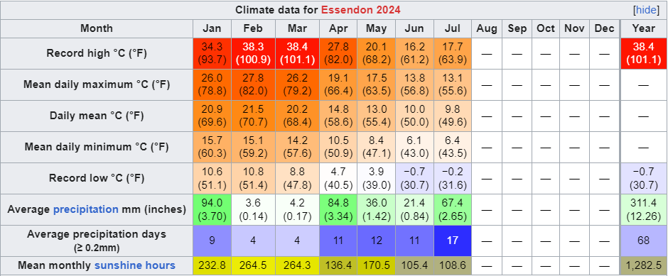
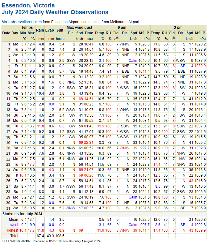
Essendon July 2024 Summary:Average max: 13.1°C (-0.8°C) Average mean: 9.8°C (-0.3°C) Average min: 6.4°C (+0.2°C) Max high: 17.7°C (23rd) Max low: 10.1°C (25th) Min high: 9.9°C (6th) Min low: -0.2°C (4th) Precipitation: 67.4mm (184.2% of avg. precip) Precip days: 17 Precip days (>1mm): 13 Sun hours: 108.6 hrs (77.9% of avg sun hours) <- new record! Highest wind gust: 69km/h from the N (11th, 19th, 24th, 25th, nice) A very wet and cloudy month. It was the cloudiest on record and wettest July since before 2003 (as there is a gap in records between 1986 and 2003). Start of the month was quite cold, with the temperature not exceeding 13C until the 7th. There were a few milder spikes throughout the month but temperatures mostly remained cooler than average. A nice change for July which is usually a drizzly and boring month, there were a couple of significant rain events this time around.  
|
|
|
|
Post by Benfxmth on Aug 1, 2024 7:46:29 GMT -5
Warm and wet month with an abundance of storms, with an unprecedented 3-day run of 79°F (26°C) lows mid-month! What a difference a month makes in the precip department. Multiple stalled cold fronts enhanced convective coverage, being the wettest month since July 2022. Been 13 >=75°F lows at the AP, of which only 1984 and 2011 had seen more, daily mins have been more impressive than daily maxes. Some lost potential due to two polar outbreaks that sent drier air filtering in, with the lowest July monthly min temp since 2021 (and also equalling the monthly mean min for 1991-2020), which prevented this month from becoming one of top 10 hottest, this is nonetheless one of the better months I've experienced in recent memory.    Average 2 AM temperature: 76.8°F (24.9°C) Average 8 AM temperature: 78.2°F (25.7°C) Average 2 PM temperature: 86.4°F (30.2°C) Average 8 PM temperature: 81.3°F (27.3°C) Average 2 AM dewpoint: 74.2°F (23.2°C) Average 8 AM dewpoint: 75.2°F (24.0°C) Average 2 PM dewpoint: 75.7°F (24.3°C) Average 8 PM dewpoint: 74.7°F (23.8°C) Max. dewpoint: 84.2°F (29.0°C) on the 15th, 1:06 PM; dry-bulb temperature 91.3°F (32.9°C) Min. dewpoint: 61.2°F (16.2°C) on the 2nd, 2:37 PM; dry-bulb temperature 82.3°F (27.9°C) Difference between true daily mean vs. max/min / 2: -1.0°F (-0.6°C) Largest diurnal range: 20.0°F (11.1°C) on the 4th Smallest diurnal range: 7.6°F (4.2°C) on the 26th Mean time of daily high and mean daily high/solar noon timing offset (not including highs which occurred at night): 2:29 PM; +1 hrs and 16 mins No. precipitation days (>=0.01"): 19 No. precipitation days (>=0.04"): 16 No. precipitation days (>=0.1"): 13 No. precipitation days (>=0.4"): 8 No. precipitation days (>=1"): 5 Max. rainfall rate (1-min. avg.): 7.20"/hr (182.9 mm/hr) on the 12th, 6:08 PM Max. rainfall rate (10-min. avg.): 3.24"/hr (82.2 mm/hr) on the 8th, 11:32-11:42 AM Max. temperature of measurable precipitation: 85.9°F (29.9°C) on the 15th, 2:55 PM Min. temperature of measurable precipitation: 72.2°F (22.3°C) on the 21st, 1:21 AM Highest barometric pressure: 30.24 in (1024.0 mb) on the 25th Lowest barometric pressure: 29.88 in (1011.9 mb) on the 5th _______________________________________________________________________ New/Tied (Monthly) Records at New Bern ASOS (KEWN): - Greatest number of precip days with at least 0.4" of rain (10, previous record 9 in 2012) _______________________________________________________________________ Monthly departures at New Bern ASOS (relative to 1991-2020 normals): Average high: +0.1°F (+0.1°C; 55th percentile; 33rd warmest on record) Mean: +1.1°F (+0.6°C; 77th percentile; 17th warmest on record) Average low: +2.1°F (+1.2°C; 89th percentile; 8th warmest on record) Precipitation: +6.06" (+153.9 mm; 197% of normal; 96th percentile; 3rd wettest on record) ________________________________________________________________________  |
|
|
|
Post by kronan2 on Aug 1, 2024 10:14:48 GMT -5
 avg high: -1.5C mean: -0.5C avg low: +0.6C precipitation: +47% sunshine: -46h  |
|
|
|
Post by B87 on Aug 1, 2024 11:13:42 GMT -5
London July 2024 Summary Slightly cooler and cloudier than average, but very wet. It was a month of 2 halves, with the first half barely averaging 21c, 81.0mm rainfall, and 56.6 hours of sun. The 2nd half averaged 26c, 2.6mm rainfall, and 144.6 hours of sun.  Mean Temp: -0.4c Sunshine: 92% Rainfall: 183% |
|
Deleted
Deleted Member
Posts: 0
|
Post by Deleted on Aug 1, 2024 14:29:19 GMT -5
July 2024 was SeaTac's 3rd warmest July on record. SeaTac broke its record streak of 15 consecutive 80°F+ days in this month as well. This was probably my favorite July I've ever experienced. All it's missing is a little thunderstorm activity.  |
|
|
|
Post by Steelernation on Aug 1, 2024 19:18:21 GMT -5
Last two days are missing from the nearest station here in Minnesota but it was an average, very stable, and dry month. Only 4-5 storms and 1 interesting hot day. Here's Fort Collins even though I didn't spend any time there this month. 3rd driest May-July, behind just 1919 and 2016. Average high: 89.8 (+2.4 f) Average low: 57.5 (-1.3 f) Mean: 73.6 (+0.5) Precipitation: 0.62" (38%, -1.01") Precip days: 9 Highest temp: 102 on the 12th --T-2nd warmestLowest temp: 51 on the 6th and 8th Highest low: 66 on the 31st Lowest high: 80 on the 21st --T-4th warmestDays with thunder: 10 Other stats: > Median high: 90.0 (+0.2 f from mean)Median low: 58.0 (+0.5 f from mean)True daily mean: 74.2 (+0.6 f)Mean dew point: 47.0
Mean RH%: 43.9%
Highest dew: 67.4 f on the 1st
Lowest dew: 20.0 f on the 3rd
Lowest relative humidity: 6.6% on the 12th (101.7 f with a 24.8 f dew)
Days max dew >60: 7
Days max dew >65: 1
Mean wind speed: 7.0 mph at Loveland airport
Max 5 minute rain rate: 1.68"/hour on the 12th
Mean 3 PM temp: 85.6
Mean 3 PM dew: 43.5
Mean 3 PM RH: 25.8%
Mean 9 AM temp: 74.1
Mean 9 AM dew: 49.6
Mean 9 AM RH: 43.5%
Sunshine hours*: 316 hours
Sunshine percent: 69%

<
Month (00-00, AgMet):  Year (1900-1900, Coop)  [/span][/font][/spoiler] |
|
|
|
Post by greysrigging on Aug 1, 2024 19:35:13 GMT -5
Essendon July 2024 Summary:Average max: 13.1°C (-0.8°C) Average mean: 9.8°C (-0.3°C) Average min: 6.4°C (+0.2°C) Max high: 17.7°C (23rd) Max low: 10.1°C (25th) Min high: 9.9°C (6th) Min low: -0.2°C (4th) Precipitation: 67.4mm (184.2% of avg. precip) Precip days: 17 Precip days (>1mm): 13 Sun hours: 108.6 hrs (77.9% of avg sun hours) <- new record! Highest wind gust: 69km/h from the N (11th, 19th, 24th, 25th, nice) A very wet and cloudy month. It was the cloudiest on record and wettest July since before 2003 (as there is a gap in records between 1986 and 2003). Start of the month was quite cold, with the temperature not exceeding 13C until the 7th. There were a few milder spikes throughout the month but temperatures mostly remained cooler than average. A nice change for July which is usually a drizzly and boring month, there were a couple of significant rain events this time around.   Only below the 2003-2020 means... if you use all available data back to 1939 it looks like this:  |
|
|
|
Post by jgtheone on Aug 1, 2024 20:25:44 GMT -5
Essendon July 2024 Summary:Average max: 13.1°C (-0.8°C) Average mean: 9.8°C (-0.3°C) Average min: 6.4°C (+0.2°C) Max high: 17.7°C (23rd) Max low: 10.1°C (25th) Min high: 9.9°C (6th) Min low: -0.2°C (4th) Precipitation: 67.4mm (184.2% of avg. precip) Precip days: 17 Precip days (>1mm): 13 Sun hours: 108.6 hrs (77.9% of avg sun hours) <- new record! Highest wind gust: 69km/h from the N (11th, 19th, 24th, 25th, nice) A very wet and cloudy month. It was the cloudiest on record and wettest July since before 2003 (as there is a gap in records between 1986 and 2003). Start of the month was quite cold, with the temperature not exceeding 13C until the 7th. There were a few milder spikes throughout the month but temperatures mostly remained cooler than average. A nice change for July which is usually a drizzly and boring month, there were a couple of significant rain events this time around. Only below the 2003-2020 means... if you use all available data back to 1939 it looks like this:  I've been using 2003-2023 for a while now. I try to make it clear where possible. |
|
|
|
Post by Morningrise on Aug 1, 2024 22:48:51 GMT -5
July ended up being hot and dry, with very little wind at times (including during one of the hottest periods of the month) - a stark contrast to the cool, rainy, and very windy spring we had. This was the first month of the year with below average precipitation, and we ended up getting a bunch of smoke throughout the month from fires in Alberta and BC, though thankfully nowhere near as bad as last year. Average high: 28.0C (normal: 25.3C) Average low: 15.1C (normal: 12.6C) Mean temperature: 21.6C (normal: 19.0C) Warmest high: 34.5C (July 18th) Warmest low: 21.0C (July 11th) Coldest high: 19.8C (July 27th) Coldest low: 10.3C (July 15th) Precipitation: 21.9mm (normal: 60.1mm) Precipitation days: 7 (normal: 12.0) Sun hours: 327.1 (normal: 305.5)  |
|
|
|
Post by Moron on Aug 1, 2024 23:31:01 GMT -5
Perth Metro Summary July 2024 It finally happened, an above average rainfall month. The first since June 2023, and it was quite lovely. Wet, good mix of cloud and sun, some nice big cold fronts coming across the coastline. As well as spells of fine, sunny, high pressure weather in the middle. A period of milder nights and days brought this month somewhat above average after quite an average first half of the month. Overall it was wetter, cloudier than average and somewhat mild. High Max: 23.5C (17th) Mean Max: 19.5C (+1.0C) Low Max : 16.0C (24th) Anomaly: +1.3C High Min: 14.2C (10th) Mean Min: 9.7C (+1.6C) Low Min : 3.5C (3rd) Rain: 170.0mm (115.6% of average 147.7mm) Rain Days >0.2mm: 23 (+4.8) Sun: 177.1hrs Sun hrs/day: 5.7 (-0.4 hrs)  Will post Leinster and some regional places later as a half-year summary |
|
|
|
Post by cawfeefan on Aug 2, 2024 4:18:22 GMT -5
July 2024 SummaryAverage max: 13.1c (-0.6c) Average mean: 9.4c (-0.6c) Average min: 5.7c (-0.5c) Max high: 17.6c (23rd) Max low: 12.0c (25th) Min high: 9.1c (6th) Min low: -1.8c (3rd) Precipitation: 141.2 mm (219.6% of mean) Days with precip: 21 Days with precip (>= 1 mm): 17 Sunshine hours: 108.6 It was a cooler, wetter and cloudier than average month. The first week was cold and dry with frosty nights. The rest of the month was quite wet with multiple rain events and while it warmed up, it was still generally on the cooler side. This month featured the second wettest July on record with records dating back to 1948, so that was something notable. As JG has said, it was also the cloudiest July on record for the airport. Overall it was a good month with lots of rain and wintry temps. 
|
|
|
|
Post by greysrigging on Aug 2, 2024 4:48:56 GMT -5
July 2024 SummaryAverage max: 13.1c (-0.6c) Average mean: 9.4c (-0.6c) Average min: 5.7c (-0.5c) Max high: 17.6c (23rd) Max low: 12.0c (25th) Min high: 9.1c (6th) Min low: -1.8c (3rd) Precipitation: 141.2 mm (219.6% of mean) Days with precip: 21 Days with precip (>= 1 mm): 17 Sunshine hours: 108.6 It was a cooler, wetter and cloudier than average month. The first week was cold and dry with frosty nights. The rest of the month was quite wet with multiple rain events and while it warmed up, it was still generally on the cooler side. This month featured the second wettest July on record with records dating back to 1948, so that was something notable. As JG has said, it was also the cloudiest July on record for the airport. Overall it was a good month with lots of rain and wintry temps.  Again... use the long term data as opposed to only 30 years....it actually looks this:   |
|
|
|
Post by Beercules on Aug 2, 2024 5:04:55 GMT -5
Melbourne winters are something else. Pure regurgitated bile.
|
|
|
|
Post by Kaleetan on Aug 2, 2024 10:10:39 GMT -5
|
|


 Lived:

 Residence:


