|
|
Post by greysrigging on Aug 31, 2024 3:05:49 GMT -5
Another month closer to the 'build up' and heat and humidity for the Top End, and the heat and dry for Central Australia. As is the norm, August was a rainless month in Darwin and Alice Springs. A few showers reported from over the far north eastern coast of the Top End with 4.8mm at Gove Airport and a couple of mm at some nearby Blackfella communities. The outstanding feature of the month has been the record breaking heat of the second half of the month.... literally dozens of sites all over the NT broke August and 'winter' heat records, both for daily and monthly maxima. The stand out max was the first recording of an NT 40c max in August at Bradshaw out in the VRD district and Alice Springs, despite a cool/cold start to August ( including a -2.5c min on the 1st ) ended up +2.8c for mins and an astounding +5.6c for max temps ! The Alice also set a new monthly mean max and broke their highest recorded August max temp record on consecutive days. These records all time for August.( since 1882 ). Darwin rural areas away from the coast also broke daily and monthly heat records for August. The Airport site recorded August anomalies of +1.3c ( mins ) and +1.6c ( maxs ) The August mean max of 33.1c is in the 95% ile of all Augusts since 1941. 4 days exceeded 35c.... a formally rare occurrence in August, but happens more frequently in the 2020's.  Rainfall - 0.0mm rainfall ( long term mean 4.5mm, median 0.0mm ) Highest daily fall - 0.0mm Max temps - 33.1c av ( long term mean 31.5c ) Highest max 35.6c on the 21st. Lowest max 30.4c on the 14th Min temps - 21.6c av ( long term mean 20.3c ) Highest min 24.6c on the 25th. Lowest min 18.5c on the 14th.    Rainfall - 0.0mm falling on 0 days ( long term mean 8.2mm) Highest daily fall 0.0mm Max temps - 28.4c av ( long term mean 22.8c) Highest max 30.6c on the 30th. Lowest max 18.6c on the 5th Min temps - 8.7c av ( long term mean 5.9c ) Highest min 20.9c on the 21st. Lowest min -2.5c on the 1st.   |
|
|
|
Post by Beercules on Aug 31, 2024 3:13:14 GMT -5
Insane. Now post all the 40C occurances in Australia during this winter month.
MTD high here is 21.4C, much warmer than avg. I forgot it's winter.
|
|
|
|
Post by greysrigging on Aug 31, 2024 3:50:35 GMT -5
Insane. Now post all the 40C occurances in Australia during this winter month. MTD high here is 21.4C, much warmer than avg. I forgot it's winter. I pretty well lost count... but it is more than 20... in winter !! I'll do some research... edit/- up until a week ago only 4 +40c days AU wide in August and only 1 prior to 2020 There have been another 19 such days ( +40c in August ) since Sunday the 25th. An incredible winter heatwave... |
|
|
|
Post by Beercules on Aug 31, 2024 4:22:49 GMT -5
Insane. Now post all the 40C occurances in Australia during this winter month. MTD high here is 21.4C, much warmer than avg. I forgot it's winter. I pretty well lost count... but it is more than 20... in winter !! I'll do some research... edit/- up until a week ago only 4 +40c days AU wide in August and only 1 prior to 2020 There have been another 19 such days ( +40c in August ) since Sunday the 25th. An incredible winter heatwave... That's awesome. It more or less translated down here aswell, I can't believe how warm it's been over the last week or so. All my plants and trees are blooming like crazy. The Almond tree next door is already showing visible nuts. I have a grape vine I was supposed to prune, whoops too late, it is already full of leaves and actual developing grape clusters . |
|
|
|
Post by MET on Aug 31, 2024 18:09:14 GMT -5
August 2024 Summary in Owlthorpe, South YorkshireRecords from Sheffield So, what of August. It was very similar in temperature to July, coming in just below average, making all three summer months slightly cooler than average and being the 3rd month of 2024 to be below average. The rainfall was also well below average. August was devoid of weather in general, with no thunder or anything interesting, just some brief showers or occasional frontal rain. There were no heatwaves or cool spells. The month tops off a boring summer which will be quickly forgotten.  
|
|
|
|
Post by Cadeau on Aug 31, 2024 18:27:11 GMT -5
Paris, Île-de-France, France August 2024 Average: High 26.7°C / Low 16.8°C / Mean 21.8°CHighest: 37.1°C [12th] Lowest: 11.8°C [25th] Lowest High: 19.1°C [30th] Highest Low: 21.6°C [12th] Precipitation: 58.4 mmPrecipitation Days: 6 Sunshine Hours: 245 hours 26 minutes Sunshine Percentage: 55.4% Early August: High 27.8°C / Low 17.6°C / Mean 22.7°C / Precipitation 13.2 mm / 97:22 sunshine hours Mid August: High 26.8°C / Low 18.1°C / Mean 22.5°C / Precipitation 31.5 mm / 61:31 sunshine hours Late August: High 25.6°C / Low 15.0°C / Mean 20.3°C / Precipitation 13.7 mm / 86:33 sunshine hours   - Seoul, South Korea August 2024 Average: High 33.3°C / Low 26.3°C / Mean 29.3°CHighest: 36.4°C [13th] Lowest: 22.6°C [31st] Lowest High: 30.3°C [22nd,27th] Highest Low: 28.2°C [2nd,12th] Precipitation: 72.8 mmPrecipitation Days: 8 Snowfall: 0.0 cm Snowy Days: 0 Average Relative Humidity: 72.6% Average Wind Speed: 2.1 m/s Sunshine Hours: 179.0 hours Sunshine Percentage: 42.6% Early August: High 33.6°C / Low 26.9°C / Mean 29.8°C / Precipitation 5.0 mm / 54.6 sunshine hours Mid August: High 34.7°C / Low 27.2°C / Mean 30.3°C / Precipitation 22.7 mm / 58.0 sunshine hours Late August: High 31.8°C / Low 24.8°C / Mean 28.0°C / Precipitation 45.1 mm / 66.4 sunshine hours   *Note 1: The warmest month ever since record began in 1908. *Note 1: The warmest month ever since record began in 1908.| Rank | Mean Temp | Year-Month | | 1st | 29.3°C | 2024-08 | | 2nd | 28.8°C | 2018-08 | | 3rd | 28.5°C | 1994-07 | | 4th | 28.1°C | 2021-07 | | 5th | 28.0°C | 2016-08 | | 6th | 27.8°C | 1943-08,2018-07 | | 8th | 27.7°C | 2013-08 | | 9th | 27.6°C | 1939-07,1994-08 |
- Tokyo, Japan August 2024 Average: High 33.6°C / Low 25.7°C / Mean 29.0°CHighest: 37.3°C [29th] Lowest: 22.1°C [17th] Lowest High: 26.9°C [12th] Highest Low: 29.3°C [29th] Precipitation: 381.0 mmPrecipitation Days: 11 Snowfall: 0 cm Snowy Days: 0 Average Relative Humidity: 79% Average Wind Speed: 3.0 m/s Sunshine Hours: 189.8 hours Sunshine Percentage: 45.5% Early August: High 34.5°C / Low 25.6°C / Mean 29.4°C / Precipitation 76.5 mm / 69.6 sunshine hours Mid August: High 34.5°C / Low 26.2°C / Mean 29.9°C / Precipitation 112.5 mm / 72.9 sunshine hours Late August: High 31.9°C / Low 25.4°C / Mean 28.0°C / Precipitation 192.0 mm / 47.3 sunshine hours   - Explains why night temperature couldn't cool down at all in the East Asia.  |
|
|
|
Post by 🖕🏿Mörön🖕🏿 on Aug 31, 2024 19:15:24 GMT -5
Very similar to July but drier and honestly a bit more boring. My prediction of it being wet after a dry July was very wrong. Perhaps September will be wet then. That would at least continue the pattern this year of the wettest months being in equinox/solstice months and the other months being considerably drier. Hard to complain about this month though. It was very pleasant. I just hope September isn't cold as fuck.  |
|
|
|
Post by CRISPR on Aug 31, 2024 22:50:20 GMT -5
Ulladulla 2024 July Summary:August was a polarising month, as spring entered in full-force!. Mean maxima were above the 95th percentile; while mean minima absolutely destroyed 2007 to become the highest on record. ( +1.8ºC / +2.1ºC). Expectedly, rainfall was very low: 31% norm); while sun hours were higher than normal ( +10.9 hrs). The beginning of August was cool and dry, with the lowest maximum (14.8ºC on the 1st) and lowest minimum occurring (5.6ºC on the 3rd). The middle of the month was a little warmer and sunnier, with some drizzle occurring. Towards end of the month, thanks to northwesterlies from the Outback, caused my town to record its 2nd highest maximum on record (27.3ºC on the 24th) and its highest minimum on record (17.3ºC on the 28th). Summaries:  Misc Stats: Misc Stats:Temperature:Mean Max: 19.3ºC ( +1.8ºC) Mean Min: 11.5ºC ( +2.1ºC) Highest Max Temp: 27.3ºC on the 24th (NNW, 19 km/h)- 2nd highest!! Lowest Max Temp: 14.8ºC on the 1st (SSW, 22 km/h) Highest Min Temp: 17.3ºC on the 28th (WNW, 33 km/h)- New record!!! Lowest Min Temp: 5.6ºC on the 3rd (N, 2 km/h) Rainfall:Total: 22.8 mm ( 31% norm) Wettest day: 8.4 mm on the 13th (Calm/NE wind) No. Days ≥ 0.2 mm (10 days) ( 82% norm) ≥ 1.0 mm (5 days) ( 94% norm) ≥ 10 mm (0 days) ( 0% norm) ≥ 25 mm (0 days) ( 0% norm) Wind:Mean 9 am wind: 9 km/h ( -4.5 km/h) Mean 3 pm wind: 12 km/h ( -6.1 km/h) Max Wind Gust: 89 km/h on the 28th (11:08 am, NW) Calmest @ 9 am: Calm on the 13th and 14th Windiest @ 9 am: 33 km/h WNW on the 28th Calmest @ 3 pm: 6 km/h SSE/NE/E/NNE on the 6th/7th/11th/25th Windiest @ 3 pm: 24 km/h NW on the 30th Humidity: Mean 9 am humidity: 66% ( +6% norm) Mean 3 pm humidity: 61% ( +5% norm) Lowest 9 am: 28% on the 28th (22.7ºC) Highest 9 am: 98% on the 15th (14.0ºC) Lowest 3 pm: 28% on the 29th (21.5ºC) Highest 3 pm: 91% on the 14th (15.7ºC) Sunshine: (Since Ulladulla does not record sunshine manually, data was calculated from link) Mean solar exposure: 12.9 MJ/m2 ( +0.8 hrs) Lowest solar exposure: 6.8 mJ/m2 (14th, 14% possible) (1.5 hours) Highest solar exposure: 16.8 mJ/m2 (31st, 83% possible) (9.4 hours) Monthly sunshine hours: 230.9 hours (+10.9 hr) Percent possible sunshine: 70%- 2nd highest!! Pressure + Diurnals:Mean Pressure: 1020.6 hPa at 9 am, 1017.8 hPa at 3 pm Max Pressure: 1033.8 hPa at 9 am (1st) Min Pressure: 997.0 hPa at 3 pm (30th) Mean diurnal: 7.8ºC ( -0.3ºC) Highest diurnal: 13.4ºC on the 27th (27.3/14.5) Lowest diurnal: 2.7ºC on the 14th (16.1/13.4)
|
|
|
|
Post by jgtheone on Sept 1, 2024 3:47:41 GMT -5
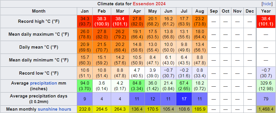
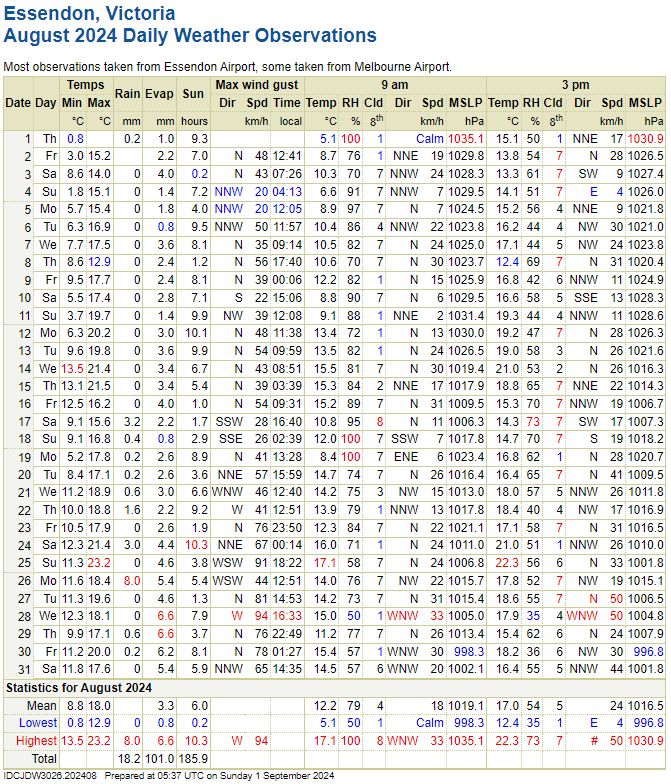
Essendon August 2024 Summary:Average max: 18.0°C (+2.9°C) <- New record! Average mean: 13.4°C (+2.5°C) <- New record! Average min: 8.8°C (+2.2°C) <- New record! Max high: 23.2°C (25th) Max low: 13.5°C (14th) Min high: 12.9°C (8th) Min low: 0.8°C (1st) Precipitation: 18.2mm (42.7% of avg. precip) Precip days: 11 Precip days (>1mm): 4 Sun hours: 185.9 hrs (110.9% of avg sun hours) Highest wind gust: 94km/h from the W (28th) This was, by far, the warmest August month on record. It started out somewhat normal for the first week and from then on it was solidly above average. In fact, this would have been an above average month in September, that's how warm it was. There were 6 20C+ days, and all but 3 days exceeded the 2003-2023 average high for August. Using the long term averages, it was probably all but 1. Melbourne CBD (and all metro sites for that matter) had their warmest Augusts on record as well. Sunshine was above average and rainfall was below average. The final week of August was also notably windy, with most days recording 70km/h+ gusts.  
|
|
|
|
Post by Benfxmth on Sept 1, 2024 8:33:30 GMT -5
August / Boregust 2024 Crummary for New BerneThe concluding month of boreal summer was also the first month of this year to not be above average, and Boregust was lame as shit compared to this July overall, except for some epic storms/downpours and heavy rain while Tropical Storm Debby exerted its influence followed by a stalled front (see: cdweather.boards.net/post/279194/thread). Otherwise, not much to write home about, with some stupidly cold lows the latter half of the month. In fact, THE COLDEST AUGUST MIN TEMP IN 20 YEARS HAVE OCCURRED ON THE MORNING OF THE 22nd. The high rain total didn't feel as wet as it seems at first glance, as almost all of it came over a few days. I hear you say, "but Benny, 87/70°F is still a respectable summer month". Well true, though in the context of the sheer epicness of most of July with its incessant 75+°F lows and also compared to August 2023, and also because a significant chunk of the month was mostly devoid of interesting weather (i.e. interesting heatwaves or thunderstorms or high dewpoints), a heat foamer would be jaded.    Average 2 AM temperature: 74.4°F (23.6°C) Average 8 AM temperature: 75.2°F (24.0°C) Average 2 PM temperature: 83.4°F (28.6°C) Average 8 PM temperature: 78.9°F (26.1°C) Average 2 AM dewpoint: 71.7°F (22.1°C) Average 8 AM dewpoint: 72.5°F (22.5°C) Average 2 PM dewpoint: 73.0°F (22.8°C) Average 8 PM dewpoint: 72.7°F (22.6°C) Max. dewpoint: 82.7°F (28.2°C) on the 10th, 2:30 PM; dry-bulb temperature 86.4°F (30.2°C) Min. dewpoint: 54.6°F (12.6°C) on the 21st, 3:45 PM; dry-bulb temperature 76.6°F (24.8°C) Difference between true daily mean vs. max/min / 2: -0.7°F (-0.4°C) Largest diurnal range: 20.8°F (11.6°C) on the 28th Smallest diurnal range: 4.4°F (2.4°C) on the 7th Mean time of daily high and mean daily high/solar noon timing offset (not including highs which occurred at night): 2:36 PM; +1 hrs and 25 mins No. precipitation days (>=0.01"): 11 No. precipitation days (>=0.04"): 11 No. precipitation days (>=0.1"): 8 No. precipitation days (>=0.4"): 7 No. precipitation days (>=1"): 5 Max. rainfall rate (1-min. avg.): 6.60"/hr (167.6 mm/hr) on the 11th, 3:08 PM Max. rainfall rate (10-min. avg.): 5.76"/hr (146.3 mm/hr) on the 11th, 3:02-3:12 PM Max. temperature of measurable precipitation: 84.9°F (29.4°C) on the 4th, 12:48 PM Min. temperature of measurable precipitation: 73.0°F (22.8°C) on the 20th, 12:21 AM Highest barometric pressure: 30.31 in (1026.4 mb) on the 23rd Lowest barometric pressure: 29.70 in (1005.7 mb) on the 8th _______________________________________________________________________ New/Tied (Monthly) Records at New Bern ASOS (KEWN): None _______________________________________________________________________ Monthly departures at New Bern ASOS (relative to 1991-2020 normals): Average high: -0.6°F (-0.3°C; 33rd percentile; 24th coldest on record) Mean: -0.1°F (-0.1°C; 40th percentile; 29th coldest on record) Average low: +0.4°F (+0.2°C; 48th percentile; 35th coldest on record) Precipitation: +6.23" (+158.2 mm; 191% of normal; 96th percentile; 3rd wettest on record) ________________________________________________________________________ 
|
|
|
|
Post by cawfeefan on Sept 1, 2024 9:13:20 GMT -5
August 2024 Summary
Average max: 17.8c (+3.2c) -> Record! Average mean: 13.3c -> Record! Average min: 8.7c (+2.3c) -> Record! Max high: 23.3c (25th) Max low: 13.7c (15th) Min high: 13.8c (3rd) Min low: -0.8c (1st) Total precipitation: 15.6mm (22.3% of mean) -> Record! Precipitation days: 10 Precipitation days (>= 1mm): 5 Sunshine hours: 185.9 What an extraordinary month it was! The month opened with a frosty morning and a relatively normal first week, but from then onwards it was pretty much spring weather. Not only were we record warm for maxima and minima, but we also smashed the previous average max and min records by 1.0c and 0.6c respectively, and that is with records going back to 1948. That alone would have made the month notable, but we also had the driest August on record by quite a large margin. To be fair, it seemed like the station wasn't recording rain properly on the 25th, when there was a strong thunderstorm that dumped torrential rain for a good 15 minutes (and I was just down the road from the weather station during the deluge). Only 1.2mm was recorded for that day, but it was probably more like 8-10mm in reality. Regardless, it would have still been a record dry month. The final week was very windy as there was a series of fronts that moved in. All in all, a very memorable month. 
|
|
|
|
Post by Steelernation on Sept 1, 2024 10:06:08 GMT -5
August was warm and wet, although nearly all the precipitation fell in the first half when I wasn't there. There was a cold front with several very cool, rainy days early on but otherwise a pretty stable month. Average high: 87.5 (+2.5 f) Average low: 58.1 (+1.6 f) Mean: 72.8 (+2.1 f) --T-8th warmestPrecipitation: 2.01" (139%, +0.56") Precip days: 10 Highest temp: 97 on the 2nd Lowest temp: 49 on the 31st Highest low: 65 on the 19th Lowest high: 65 on the 9th --T-coolest since 2008Days with thunder: 10 Other stats: > Median high: 90.0 (+2.5 f from mean)Median low: 58.0 (-0.1 f from mean)True daily mean: 72.7 (-0.1 f) Mean dew point: 52.2 Mean RH%: 54.9% Highest dew: 72.6 f on the 7th Lowest dew: 22.4 f on the 31st Lowest relative humidity: 8.5% on the 31st (90.1 f with a 22.4 f dew) Days max dew >60: 15 Days max dew >65: 3 Mean wind speed: 7.2 mph at Loveland airport Max 5 minute rain rate: 3.72"/hour on the 13th Mean 3 PM temp: 83.6 Mean 3 PM dew: 49.6 Mean 3 PM RH: 36.1% Mean 9 AM temp: 70.9 Mean 9 AM dew: 54.0 Mean 9 AM RH: 57.9% Sunshine hours*: 280 hours Sunshine percent: 66%  < Month (AgMet, 00-00):  Year (Coop, 1900-1900):  |
|
|
|
Post by Kaleetan on Sept 1, 2024 12:21:35 GMT -5
|
|
|
|
Post by arcleo on Sept 1, 2024 12:43:00 GMT -5
August was a bit of a cooler, but still good summer month. It had more thunderstorms than July, including two pretty strong ones. It was almost consistently below average from August 11 onwards, but again, still nice summer weather and definitely better than Seattle or SLO could get. Data was missing for August 11-14, so I used data from Westerly, RI. Also note that the station is right on the coast and the highs are usually a bit warmer just a few km/miles inland.   |
|
|
|
Post by tommyFL on Sept 1, 2024 13:39:28 GMT -5
August 2024 SummarySlightly warmer than normal (+0.2 °F/+0.1 °C/67th percentile) with near-normal precipitation (106% of average precipitation/48th percentile)The most humid month by mean dew point since the start of my observations in March 2021 Not a terrible month by summer 2023 and 2024 standards, certainly better than the two prior months at least.    Highest daily max temp: 95.0 °F (35.0 °C) on the 10th Mean daily max temp: 90.5 °F (32.5 °C)Lowest daily max temp: 85.7 °F (29.8 °C) on the 3rd Highest daily mean temp: 83.7 °F (28.7 °C) on the 2nd Mean temp: 81.0 °F (27.2 °C)Lowest daily mean temp: 76.7 °F (24.8 °C) on the 22nd Highest daily min temp: 79.6 °F (26.4 °C) on the 7th Mean daily min temp: 75.0 °F (23.9 °C)Lowest daily min temp: 71.1 °F (21.7 °C) on the 29th Highest diurnal range: 21.6 °F (12.0 °C) on the 10th Mean diurnal range: 15.6 °F (8.7 °C)Lowest diurnal range: 9.1 °F (5.1 °C) on the 8th Precipitation: 8.89" (225.8 mm)Number of days with precipitation ≥ 0.01" (0.3 mm): 21 daysHighest daily precipitation: 2.10" (53.3 mm) on the 15th Highest instantaneous precipitation rate: 8.65"/hr (219.7 mm/hr) on the 3rd Duration of measurable precipitation: 34.2 hours (4.7% of the month)Highest temp with measurable precipitation: 90.3 °F (32.4 °C) on the 20th Mean temp of measurable precipitation: 78.4 °F (25.8 °C)Lowest temp with measurable precipitation: 71.1 °F (21.7 °C) on the 29th Highest relative humidity: 100% on 30 days Mean daily max relative humidity: 99.9%Highest daily mean relative humidity: 98.4% on the 6th Mean relative humidity: 90.6% Lowest daily mean relative humidity: 81.9% on the 18th Mean daily min relative humidity: 66.8%Lowest relative humidity: 51% on the 19th Highest dew point: 84.5 °F (29.2 °C) on the 1st Mean daily max dew point: 81.9 °F (27.7 °C)Highest daily mean dew point: 80.2 °F (26.8 °C) on the 7th Mean dew point: 77.6 °F (25.3 °C)Lowest daily mean dew point: 72.8 °F (22.7 °C) on the 18th Mean daily min dew point: 74.0 °F (23.3 °C)Lowest dew point: 70.5 °F (21.4 °C) on the 18th Highest barometric pressure: 30.14 inHg (1021 mbar) on the 1st Mean barometric pressure: 29.99 inHg (1016 mbar)Lowest barometric pressure: 29.71 inHg (1006 mbar) on the 7th Largest 1-day mean temp rise: 3.4 °F (1.9 °C) between the 12th and 13th Largest 1-day mean temp drop: 4.3 °F (2.4 °C) between the 21st and 22nd Mean daily variability (average difference in mean temp between consecutive days): 1.6 °F (0.9 °C)Observations are from 12 AM to 12 AM New August monthly records at Port Salerno 5W COOP station (1.3 mi/2.1 km SE) (since May 2002):No new monthly recordsObservations are from 7 AM to 7 AM Full period of record averages for Port Salerno 5W COOP station for reference: Sunshine hours at Martin County Emergency Operations Center for 2024 and averages since 2020 (calculated from solar radiation):  Highest daily sunshine: 83% (10.7 hours) on the 18th Lowest daily sunshine: 0% (0.0 hours) on the 3rd, 15th, and 22nd ************************************* My other stations Allapattah Flats (precipitation data beginning August 25th):   Highest relative humidity: 100% on the 1st, 12th, 16th, 23rd, 26th, 27th, 29th, and 30th Lowest relative humidity: 49% on the 13th Highest dew point: 82.9 °F (28.3 °C) on the 11th Lowest dew point: 68.4 °F (20.2 °C) on the 18th
|
|
|
|
Post by Shaheen Hassan on Sept 1, 2024 14:42:31 GMT -5
Most of southwestern Arabian Peninsula, including Yemen's capital San'aa, had an exceptionally wet August. See the rainfall data for August in San'aa. I made this file myself and gathered data from daily rainfall reports by YMS.  |
|
|
|
Post by Moron on Sept 1, 2024 19:01:49 GMT -5
August 2024 Summary: High Max: 26.2C (10th) Mean Max: 19.9C (+0.8C) Low Max : 16.4C (17th) Anomaly : +1.9C High Min: 15.8C (27th) Mean Min: 11.4C (+3.0C) Low Min : 3.3C (4th) A very mild (lows) month, generally cloudier than average, wet (lots of showery days) with prevailing W winds. From the 6th onwards there were 3 lows below 10.0C, the monthly average minimum is 8.4C. August started sunny with wide diurnals for the first 6 days before a pattern of mild cloudy weather settled in for the remainder of the month. Periods of 20/13 days were common with showery periods interchanging with short sunny spells. Regular high pressure off of the WA coast kept conditions cloudy, mild at night with onshore showers pushing through quite often. Rainfall: 138.4mm (133.2% of average 122.2mm) Rain D. : 25 days (+9.2 days) Sun hrs : 181.1 hrs Hrs per day: 5.6 (-1.5hrs per day)  |
|
|
|
Post by greysrigging on Sept 1, 2024 19:06:20 GMT -5
Most of southwestern Arabian Peninsula, including Yemen's capital San'aa, had an exceptionally wet August. See the rainfall data for August in San'aa. I made this file myself and gathered data from daily rainfall reports by YMS.  ^^ that would be an above average wet season month in Darwin !! ^^ |
|
Deleted
Deleted Member
Posts: 0
|
Post by Deleted on Sept 1, 2024 20:01:31 GMT -5
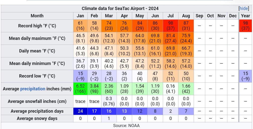
August finished off cooler and wetter than normal. Had a really good thunderstorm on the night of the 18th which delivered significant rainfall to the area. One location in Bellevue recieved over 3 inches from these storms. While SeaTac couldn't pull off a sub 50°F low, it did get down to 46.4°F at my PWS on the morning of the 28th.  |
|
|
|
Post by B87 on Sept 2, 2024 4:49:10 GMT -5
London August 2024  Mean temp: +0.8c Rainfall: 54% Sunshine: 105% A dry month with above average temperatures and slightly above average sun. |
|


 Lived:

 Residence:


