|
|
Post by 🖕🏿Mörön🖕🏿 on Jun 18, 2019 21:41:12 GMT -5
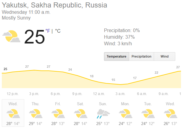
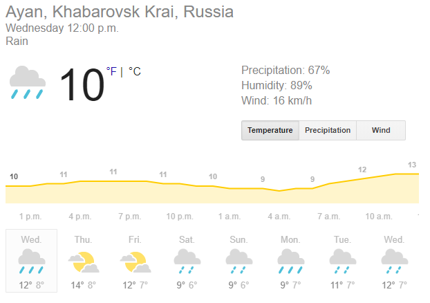
Siberia Roundup! Yakutsk is pretty warm but nothing too extreme:  But Vilyuysk? That's pretty warm but has a temporary cool down before heating up again:  Verkhoyansk is consistently warm:  Very comfortable temps in Ust-Nera:  Much cooler in Oymyakon compared to Verkhoyansk:  Very nice temps and mix of sun and rain in Khabarovsk:  Same story in Irkutsk but a bit warmer Wed/Thur:  And then we have Ayan on the coast... (Khabarovsk krai)  |
|
|
|
Post by 🖕🏿Mörön🖕🏿 on Jun 19, 2019 0:06:09 GMT -5
Update on Vilyuysk. It should easily reach 33C or even 34C today.  |
|
|
|
Post by 🖕🏿Mörön🖕🏿 on Jun 19, 2019 20:43:00 GMT -5
Considerably warm in Anchorage. 77F/25C is about the mean max there in summer. To have it so consistent is pretty unusual. Nice warm lows too. It will be much cooler and wetter here at the same time.  |
|
|
|
Post by Crunch41 on Jun 19, 2019 22:47:40 GMT -5
Possibly 4 days in a row above 24C for Ennadai, Nunavut (61N). The only weather station in Nunavut far from a coast, the only one with decent summers.
25.0/8.5 on the 17th 25.0/11.8 on the 18th 24.2/TBD today 26C tomorrow from weather.com
I might make a better wiki box one day. There are several years of data on Environment Canada. |
|
|
|
Post by nei on Jun 20, 2019 12:56:50 GMT -5
not trying to make a climate change comment; just interesting impressive warmth up there last week
|
|
|
|
Post by 🖕🏿Mörön🖕🏿 on Jun 20, 2019 23:09:07 GMT -5
Yeah it has been a warm recent few weeks at high latitudes. First with Scandinavia and the Murmansk area, and now NE Siberia, AK, YT, and Greenland simultaneously. Western NWT/northern AB was pretty warm recently but it didn't last long, unlike the heat in NE Siberia.  On Alaska's North Slope -- Umiat, AK is 80F right now (June record high is 88F/31C there).  |
|
|
|
Post by Ariete on Jun 23, 2019 14:49:22 GMT -5
Chilly week coming up in Northern Lapland.
|
|
|
|
Post by Crunch41 on Jun 25, 2019 22:16:37 GMT -5
|
|
|
|
Post by Crunch41 on Jul 8, 2019 13:45:41 GMT -5
This tiny island in Lake Superior is slowly warming up. It should reach 10C means soon.
But Cape Lopatka just reached 10C for the first time yesterday. At sea level and 51N. Terrible crummers there. Cold, no variation in temperature, and extremely cloudy. The past 7 days have recorded a total of 0.0 sun hours. June had a total of 35 sun hours which is less than 10% of possible sunshine.
|
|
|
|
Post by knot on Jul 8, 2019 18:06:14 GMT -5
Bloody oath, this is a tremendously cold week for Grytviken—just look at that blasted Thursday..!!  |
|
|
|
Post by AJ1013 on Jul 8, 2019 18:13:01 GMT -5
Bloody oath, this is a tremendously cold week for Grytviken—just look at that blasted Thursday..!!  I’ve actually been following this for a while. Grytviken may break it’s all time record low. |
|
|
|
Post by Crunch41 on Jul 19, 2019 19:12:58 GMT -5
|
|
|
|
Post by 🖕🏿Mörön🖕🏿 on Jul 22, 2019 2:24:23 GMT -5
|
|
|
|
Post by nei on Jul 29, 2019 15:44:58 GMT -5
very low sea ice this summer in the arctic. Lowest on record for today's date. Almost certainly will be among the three lowest by summer minimum
depends if a cyclone churns up water, melting more sea ice. The high pressure system that brought the European heat wave migrated to the arctic,should help melt more ice.
The upper-level high at the heart of Europe’s heat wave has now migrated north into Scandinavia, where it’s joining forces with another very strong upper high over the central Arctic. At the surface, strong high pressure is centered close to the North Pole. The pattern is keeping skies largely cloud-free and allowing still-ample summer sunlight to attack the ice in tandem with the unusual warmth flowing into the Arctic from lower latitudes. "This actually primes things for more sea ice loss later (on the order of weeks)," Cavallo said. "Temperatures will be warmer, and there will be less cloud cover to make sea ice more vulnerable if a cyclone were to develop down the road."
As the surface high weakens later this week and beyond, there will be the potential for one or more surface cyclones to develop along the edge of the remaining Arctic ice pack, where they could lead to further ice loss—but there’s no telling more than a few days out where or how strong those might be.
“Thus far, this year has been generally at or below 2012’s sea ice extent,” Labe noted. “However, there is room for caution. 2012’s Great Arctic Cyclone contributed to significant declines in sea ice extent in August. It will be difficult for 2019 to continue with a similar melt momentum without an extreme weather event, which are difficult (impossible?) to predict at this range.”
Also should be a lot of warm air over Greenland even at 10,000 at the top of the ice cap
|
|
|
|
Post by Hiromant on Jul 30, 2019 4:31:11 GMT -5
|
|
|
|
Post by 🖕🏿Mörön🖕🏿 on Aug 7, 2019 23:43:03 GMT -5
No temps above 0C in Grytviken. Currently snowing at -2C.  |
|
|
|
Post by jgtheone on Aug 8, 2019 5:15:13 GMT -5
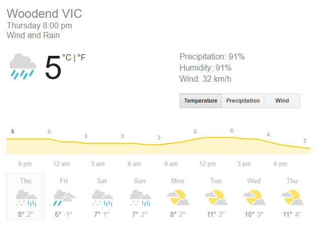
Woodend with 3 days of snow possible. Never seen anything like this  |
|
|
|
Post by 🖕🏿Mörön🖕🏿 on Aug 11, 2019 13:56:34 GMT -5
Polar thunderstorms  Close up view... ~85N  |
|
|
|
Post by 🖕🏿Mörön🖕🏿 on Aug 12, 2019 11:11:05 GMT -5
Grytviken still solidly below freezing for the foreseeable future:  Nice fetch of cold air from the Antarctic pointed right at Grytviken  |
|
|
|
Post by nei on Sept 14, 2019 8:57:00 GMT -5
interesting dramatic weather high above Antarctica. Don't quite know what it know means
but def good news if you live in the southern hemisphere mid or high latitudes, lower sunburn risk
|
|