|
|
Post by Steelernation on Sept 2, 2020 21:18:03 GMT -5
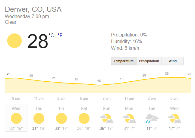
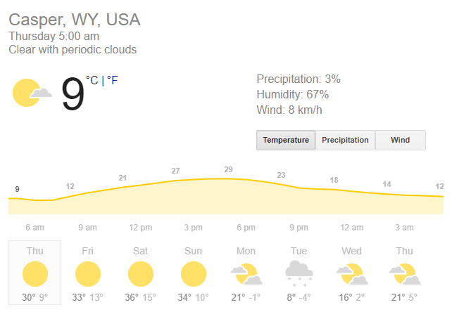
That’s a load of bullshit, it’s not gonna have 4 days with highs in the 30s with snow the first week of September.
The could eat I could see happening is like 45/28 with flurries.
That said still an epic drop in temps. Going from near the monthly record high to near 30 f below average highs in 2 days is awesome.
|
|
|
|
Post by Benfxmth on Sept 3, 2020 2:20:03 GMT -5
Jesus, that is mental. Google says this, but still a massive drop.  Here's the NWS forecast:  Slightly warmer than the Google forecast but it's still impressive to go from near record high temperatures to record low high temperatures territory! |
|
|
|
Post by knot on Sept 3, 2020 3:18:59 GMT -5
937 L positioned under AU on the 14th!  |
|
|
|
Post by jgtheone on Sept 3, 2020 6:33:34 GMT -5
This is so alien to me, and I can experience some decent temp swings of my own.  |
|
|
|
Post by Morningrise on Sept 3, 2020 8:58:58 GMT -5
We have a forecast low of 2C for tonight with a risk of frost. With August having been quite warm this year I hope we don't end up with frost right at the end of the month, please save that for September... I dont know seems like summer is ending early in most areas of the NH. I wouldn't be surprised if you got September snow tbh.. We've had snow the last two Septembers so I wouldn't expect anything less this time around  |
|
|
|
Post by shalop on Sept 3, 2020 20:55:15 GMT -5
Lol at those forecasts. Boulder is the best one I could find per Google and TWC. Sunday: 36/16 c Monday: 31/0 c Tuesday: 3/-2 c
|
|
|
|
Post by Morningrise on Sept 3, 2020 21:13:12 GMT -5
The forecast shows a high of 9C and low of 0C on Monday, if that happens it will be our coldest day in quite a long time. The last time we had a high under 10C was on May 10th and the last time we had a low at or below 0C was on May 15th. This will also mark a pretty drastic cooldown, as we have a forecast high of 24C on Saturday and 19C on Sunday. Must be related to the pattern Shalop just posted.
|
|
|
|
Post by 🖕🏿Mörön🖕🏿 on Sept 3, 2020 21:16:27 GMT -5
Lol at those forecasts. Boulder is the best one I could find per Google and TWC. Sunday: 36/16 c Monday: 31/0 c Tuesday: 3/-2 c
Damn  |
|
|
|
Post by srfoskey on Sept 3, 2020 22:44:42 GMT -5
We're supposed to have a big cooldown here as well, but it's not insane like Colorado's. We're just supposed to have a high of 86°F/30°C on Tuesday and 66°F/19°C on Wednesday. That high and the forecast low Wednesday night of 51°F/10.5°C would be just a few degrees above record low levels, but obviously it's still six days away, so a lot can change between now and then.
|
|
|
|
Post by Steelernation on Sept 3, 2020 23:02:31 GMT -5
The smoke returned today. In the late afternoon the southern half of the sky was filled with orangish clouds, very eerie looking. Made for a spectacular sunset though.
High was 81 (27 c), 90s the next few days before the epic temp crash on Tuesday.
|
|
Deleted
Deleted Member
Posts: 0
|
Post by Deleted on Sept 4, 2020 3:45:48 GMT -5
A decent chance that September will end up sunnier than August this year!
This has occured before in the following years:
1958
1968
1971
1979
2006
2008
2010
2011
2015
2018
|
|
|
|
Post by srfoskey on Sept 4, 2020 18:09:30 GMT -5
Wouldn't it be funny if Oklahoma sees the earliest snowfall on record by about a week?  |
|
|
|
Post by Giorbanguly on Sept 5, 2020 1:12:55 GMT -5
|
|
|
|
Post by Steelernation on Sept 5, 2020 3:12:50 GMT -5
90/49 f (32/9 c) today. NWS has upgraded tomorrow’s forecast to 100 f and has 98 f on Sunday, both of which will threaten the all time September record high.
Then temps crash. NWS has 42/26 and snow on Tuesday, TWC has 37/24 and snow. Both would be epic!
|
|
|
|
Post by trolik on Sept 5, 2020 19:37:47 GMT -5
Pretty hot in Southern California!
|
|
|
|
Post by shalop on Sept 5, 2020 21:39:12 GMT -5
Denver (KDEN) reached 101 today! KBDU reached at least 99, possibly 100.
According to TWC, Tuesday has been downgraded to a high of 34 in Denver and 33 in Boulder. Imagine if it keeps downgrading and they get an ice day. |
|
|
|
Post by Steelernation on Sept 5, 2020 23:09:50 GMT -5
Smoke and clouds kept temps down today so unfortunately it underperformed, only hitting 95 (35 c) while places south and east were setting records.
There was a huge smoke plume from the Cameron peak fire today. It looked very eerie in the late afternoon, the sky was reddish brown and blotted out the sun which was a big bright pink ball. The sky over the high peaks to the south was orangish yellow with clearly visible smoke plumes and it was pinkish over the mountains. Pics will be posted tomorrow. There was even ash falling from the sky and there was lots of it on the ground.
|
|
|
|
Post by jgtheone on Sept 5, 2020 23:12:05 GMT -5
Pretty hot in Southern California! What was the temperature at LA-Mex's house? |
|
|
|
Post by srfoskey on Sept 6, 2020 1:30:19 GMT -5
The NWS is now forecasting a rain/snow mix for the Oklahoma Panhandle. I've gotta say, the American High Plains have some of the most extreme day-to-day temperature variation of anywhere in the world. A similar thing actually happened in February 2017 around Altus, but it was spaced out by a few more days.  |
|
|
|
Post by Giorbanguly on Sept 6, 2020 2:39:47 GMT -5
Only registered 1504 ensoleillement hours so far for the whole year  |
|