|
|
Post by Steelernation on Sept 8, 2020 23:11:52 GMT -5
1:30 PM Sunday: 99 f, tied September record high
1:30 PM Tuesday: 34 f, earliest snowfall ever
The high today was only 41 (5 c) at midnight, which is a new daily record low! After 5:30 AM, it didn’t get above 35 (2 c)...the average high today is 79 (26 c)!
Through 7 PM, 2.3” (5 cm) of snow fell with more heavy snow after. It’s settled everywhere but roads and is a few inches deep in places.
|
|
|
|
Post by Crunch41 on Sept 9, 2020 7:48:46 GMT -5
Well forget our forecast low of -4C for last night, we went down to -5.8C at 3:00am! And that's the hourly reading, so it's possible the actual low was even colder than that. Last time we had a low as cold or colder than that was on April 15th. Now we're going back into a few days of warmer weather with highs above 20C and even one low above 10C. -6 is really cold for September 9th. In comparison - I won't see that until November. Milwaukee has some of the mildest lows in the state, and it was a warm summer, but still...the airport's "coldest" temp so far this fall is +13. A full 19 degrees warmer! I'd like to see some single digits (40s F) by now.
Central London at almost the same latitude as you might not see -6 all winter.
|
|
|
|
Post by Morningrise on Sept 9, 2020 8:09:27 GMT -5
Update: yesterday's official low was -6.9C, absolutely obliterating the previous daily record low of -1.1C. Indeed, this is the sort of temperature we would normally first experience around mid-October, not early September.
|
|
Deleted
Deleted Member
Posts: 0
|
Post by Deleted on Sept 9, 2020 8:13:43 GMT -5
Well forget our forecast low of -4C for last night, we went down to -5.8C at 3:00am! And that's the hourly reading, so it's possible the actual low was even colder than that. Last time we had a low as cold or colder than that was on April 15th. Now we're going back into a few days of warmer weather with highs above 20C and even one low above 10C. -6 is really cold for September 9th. In comparison - I won't see that until November. Milwaukee has some of the mildest lows in the state, and it was a warm summer, but still...the airport's "coldest" temp so far this fall is +13. A full 19 degrees warmer! I'd like to see some single digits (40s F) by now.
Central London at almost the same latitude as you might not see -6 all winter.
Almost certainly won't see -6c in Central London. St James's Park hasn't seen a temperature that low in the 21st century. Probably not since 1991 or 1987. |
|
|
|
Post by nei on Sept 9, 2020 14:41:56 GMT -5
|
|
|
|
Post by shalop on Sept 9, 2020 14:46:42 GMT -5
So apparently there's a new world record for the shortest amount of time between 40C and measurable snow (according to Brian Brettschneider). Rapid City hit 40C on the 5th, then got accumulating snow 56 hours later on the 7th. And this morning (the 9th) it reached -4C. |
|
|
|
Post by srfoskey on Sept 9, 2020 16:00:24 GMT -5
The daily record low max for OKC for today is 67F/19.5C. Currently the warmest it's gotten today is 56F/13C. It looks like another daily record will be obliterated. It would also be the earliest we've ever had such a cool high by four days.
|
|
|
|
Post by srfoskey on Sept 9, 2020 21:00:36 GMT -5
Also, the front has stalled out over eastern Oklahoma. I took screenshots of the temperatures every few hours, so you can see the slow passage of the front over about 30 hours. From what I gather, Oklahoma never got a freeze from the powerful cold blast. |
|
|
|
Post by Steelernation on Sept 9, 2020 23:21:57 GMT -5
High was just 42 (6 c) again today, the 2nd straight daily record low max.
It snowed in the morning before ending at 11:30 AM and then somewhat clearing up. By the evening it was pretty much all melted.
Today recorded only a trace so 2.3” (5 cm) is the official storm total. A lot less than was forecast but I don’t care, heavy snow that covers the ground in September is epic whether it’s 2” or 6”.
The coldest temp was only 31.6 (-0.2 c), but that’s still a September freeze. Guess the clouds and dampness kept the temp from falling more.
Overall an awesome cold snap capping off an epic week of weather!
|
|
|
|
Post by Crunch41 on Sept 9, 2020 23:28:43 GMT -5
I saw shoutbox posts, but no forum posts about the crazy skies in the western US. I can't comprehend the sky being this color. It looks fake Somewhere in oregon:  Near Salem, Oregon.  Source: https://www.reddit.com/r/pics/comments/ioyntd/oregon_wildfires_making_it_look_straight/ A video in Stayton, Oregon (near Salem) Taken just after noon, when the sun should be shining bright. A video of San Francisco with fitting music. Looks fake. Put sound on if you watch it. 2020 in review:  |
|
|
|
Post by jgtheone on Sept 10, 2020 9:16:06 GMT -5
|
|
|
|
Post by nei on Sept 10, 2020 13:39:55 GMT -5
shows up in solar radiation
|
|
|
|
Post by Steelernation on Sept 10, 2020 14:33:33 GMT -5
shows up in solar radiation It shows up with solar radiation here too.
link
The 8th snowed most of the day with afternoon and overcast. The 7th had heavy smoke and had about the same solar radiation. The 4th-6th were sunny for comparison. NWA updated yesterday’s snowfall to 0.4” (1 cm), which brings the storm total snowfall to 2.7”. |
|
|
|
Post by srfoskey on Sept 10, 2020 18:12:02 GMT -5
We had a bit of smoke on Monday that made the sunset very red, but it looked normal during the day.
|
|
|
|
Post by Beercules on Sept 11, 2020 1:37:32 GMT -5
Both of these are on the coast either side of the SW/WA border. Eucla's 40.1C is a new September record by 0.1C   |
|
|
|
Post by rozenn on Sept 11, 2020 6:18:32 GMT -5
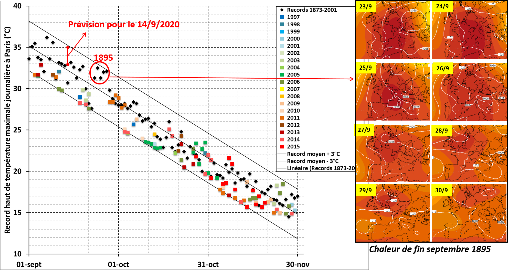
Fall daily heat records in Paris-Montsouris and Météo France's forecast for Monday. If it verifies it would be exceptional. Interesting graph on what one can reasonably expect in terms of warmth in fall. Still no 30°C+ in October.  |
|
|
|
Post by Cadeau on Sept 11, 2020 6:27:10 GMT -5
At the current level of heatwave intensity and frequency, I won't be surprised that if Montsouris records over 30°C in the first half of October and 24°C in the first half of November as the linear regression suggests in the graph.
|
|
|
|
Post by rozenn on Sept 11, 2020 7:24:11 GMT -5
Yeahthe monthly records of 29°C and 22°C seem pretty weak.
|
|
|
|
Post by Benfxmth on Sept 11, 2020 10:43:28 GMT -5
Fall daily heat records in Paris-Montsouris and Météo France's forecast for Monday. If it verifies it would be exceptional. Interesting graph on what one can reasonably expect in terms of warmth in fall. Still no 30°C+ in October.  Very interesting chart! Rome has seen a 104°F high on September 7th in 1946, with nothing coming close to that after (second hottest day for September 7th seems to be a 94.3°F high set in 2008, and the second hottest September high was 101.2°F set in September 5th in 1982): climaintoscana.altervista.org/italia/stazioni-wmo/roma-ciampino/ |
|
|
|
Post by rozenn on Sept 11, 2020 16:30:46 GMT -5
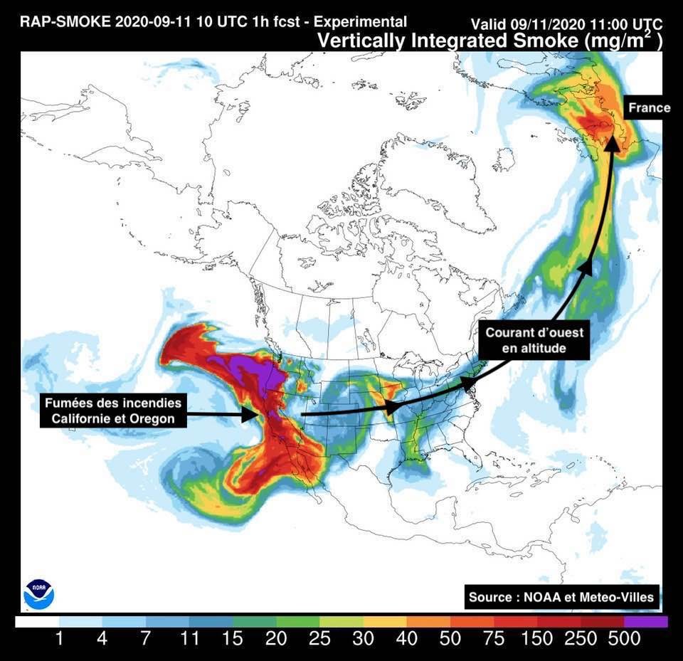
Gee no wonder I found the sky particularly hazy today. Rediculous.  |
|