|
|
Post by Benfxmth on Nov 22, 2020 19:57:52 GMT -5
A cold snap looks likely for the east for the opening of December, after a warm stretch for this week.  Heavy rain combined with temperatures in the 50's-low 60's leading up to the cold front is also forecast as well for the Northeast.   |
|
|
|
Post by nei on Nov 23, 2020 8:28:04 GMT -5
cold heavy rain this morning; cold front doesn't reach us till after sunset; Speagles84 got the rain yesterday and already has cooled down |
|
|
|
Post by Speagles84 on Nov 23, 2020 8:29:04 GMT -5
A cold snap looks likely for the east for the opening of December, after a warm stretch for this week.  Heavy rain combined with temperatures in the 50's-low 60's leading up to the cold front is also forecast as well for the Northeast.   Yes yes yes to this |
|
|
|
Post by Benfxmth on Nov 23, 2020 8:30:55 GMT -5
925 hPa temperature anomalies in the Arctic so far this month.
|
|
|
|
Post by rozenn on Nov 23, 2020 9:03:17 GMT -5
|
|
|
|
Post by Benfxmth on Nov 23, 2020 9:10:29 GMT -5
rozenn Here are this morning's lows for the rest of stations within Europe. Note that even Florence dipped to 26.2°F, this is a Perfffffff De Derffffffff situation. 
|
|
|
|
Post by AJ1013 on Nov 23, 2020 9:11:07 GMT -5
I found data for Virginia Key Pier (Just east of downtown Miami). POR is only 7 years but worth posting for the hilarious summers. Graph has averages (red) and records (blue lines)  Coldest day in the POR was 46/35 (7.9/1.8) in January 2010, hottest was 95/81 (35/27) in June 2009 |
|
|
|
Post by kronan on Nov 23, 2020 11:01:59 GMT -5
DMI released their winter-prognosis for scandinavia a couple of days ago. Look like we're in for another torching winter.
Issued November 18 - valid for January and February 2021.
There are many indications that the winter this year will be more gray than white. Several forecasts point to a northern low-pressure line, where low pressure from the Atlantic Ocean takes a north-eastern line up towards Scandinavia. Most often it will lead to a gentle flow from west and southwest with rain and wind to Denmark. Of course, snow and frost can still occur, but it does not appear to fill much in the coming months.
There are many factors on the whole globe that have an impact on how winter weather develops in Northern Europe and in Denmark.
Sea temperatures in the northern hemisphere are one of them, and as sea temperatures in many places in the North Pacific and North Atlantic are relatively high for the season, it is expected to have a major impact on our winter weather and speak for a mild and erratic winter on our latitudes.
January and February:
The forecasts show an increased probability of lower air pressure from Iceland, across the Norwegian Sea, the Arctic Ocean and into Scandinavia in both January and February. Similarly, most forecasts point to generally higher air pressures than usual south of Denmark, from around the Azores and into southern Europe and partly central Europe.
This scenario will lead to a predominantly southwesterly or westerly flow of mild air up over Northern Europe and Denmark, and most low pressures will take a course from the Atlantic to the northeast and up over Scandinavia, most often north of Denmark.
It speaks of erratic and mild winter weather, where fronts will pass from the west and southwest, and precipitation will mainly fall as rain. Fronts and low pressures will also draw a number of clouds over the country, and occasionally larger amounts of rain when the low pressures come close.
At times it will also be windy and the possibility of one or maybe a few storms can not be ruled out.
The highest probability of stormy weather is in January, but February can also offer strong winds.
Between low pressure and fronts there will be less high pressure ridge, which passes the country and gives predominantly dry weather and a chance of little or no sun.
Despite the prospect of the predominantly low-pressure winter weather, it will also be possible to build a high-pressure transition over Scandinavia or North-Eastern Europe. With the right size and location, the high pressure can block the Atlantic low pressures, and the flow will be a transition colder and drier.
For shorter periods we can get winter weather and maybe a little snow, but the mild and quite wet weather type clearly seems to dominate throughout the period.
Overall, the average temperature seems to end somewhat or maybe well above normal in both January and February - several forecasts indicate 1-2 degrees above normal temperature. Precipitation amounts appear to be around or slightly above normal for the entire period.
By long-term meteorologist Martin Lindberg
Note: The normal temperature and precipitation referred to in the forecasts are the level of the last 20 years (see also weather data for the period 2006-2015). It is therefore not the climate norm for 1961-1990 that is referred to.
|
|
|
|
Post by AJ1013 on Nov 23, 2020 11:28:38 GMT -5
Miami nor-easter of 1984. 65/60 in Miami that day with gale force winds and rain
|
|
|
|
Post by boombo on Nov 23, 2020 17:27:04 GMT -5
DMI released their winter-prognosis for scandinavia a couple of days ago. Look like we're in for another torching winter. Issued November 18 - valid for January and February 2021.
There are many indications that the winter this year will be more gray than white. Several forecasts point to a northern low-pressure line, where low pressure from the Atlantic Ocean takes a north-eastern line up towards Scandinavia. Most often it will lead to a gentle flow from west and southwest with rain and wind to Denmark. Of course, snow and frost can still occur, but it does not appear to fill much in the coming months.
There are many factors on the whole globe that have an impact on how winter weather develops in Northern Europe and in Denmark.
Sea temperatures in the northern hemisphere are one of them, and as sea temperatures in many places in the North Pacific and North Atlantic are relatively high for the season, it is expected to have a major impact on our winter weather and speak for a mild and erratic winter on our latitudes.
January and February:
The forecasts show an increased probability of lower air pressure from Iceland, across the Norwegian Sea, the Arctic Ocean and into Scandinavia in both January and February. Similarly, most forecasts point to generally higher air pressures than usual south of Denmark, from around the Azores and into southern Europe and partly central Europe.
This scenario will lead to a predominantly southwesterly or westerly flow of mild air up over Northern Europe and Denmark, and most low pressures will take a course from the Atlantic to the northeast and up over Scandinavia, most often north of Denmark.
It speaks of erratic and mild winter weather, where fronts will pass from the west and southwest, and precipitation will mainly fall as rain. Fronts and low pressures will also draw a number of clouds over the country, and occasionally larger amounts of rain when the low pressures come close.
At times it will also be windy and the possibility of one or maybe a few storms can not be ruled out.
The highest probability of stormy weather is in January, but February can also offer strong winds.
Between low pressure and fronts there will be less high pressure ridge, which passes the country and gives predominantly dry weather and a chance of little or no sun.
Despite the prospect of the predominantly low-pressure winter weather, it will also be possible to build a high-pressure transition over Scandinavia or North-Eastern Europe. With the right size and location, the high pressure can block the Atlantic low pressures, and the flow will be a transition colder and drier.
For shorter periods we can get winter weather and maybe a little snow, but the mild and quite wet weather type clearly seems to dominate throughout the period.
Overall, the average temperature seems to end somewhat or maybe well above normal in both January and February - several forecasts indicate 1-2 degrees above normal temperature. Precipitation amounts appear to be around or slightly above normal for the entire period.
By long-term meteorologist Martin Lindberg
Note: The normal temperature and precipitation referred to in the forecasts are the level of the last 20 years (see also weather data for the period 2006-2015). It is therefore not the climate norm for 1961-1990 that is referred to.Not much snow in Denmark = almost no snow in England, but that's about what I was expecting anyway. We haven't had a frost yet, this is the longest we've ever had to wait and there's still nothing below freezing in the forecast. |
|
|
|
Post by rozenn on Nov 23, 2020 18:34:43 GMT -5
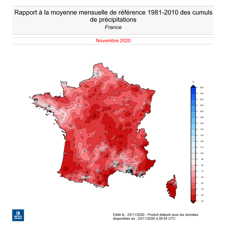
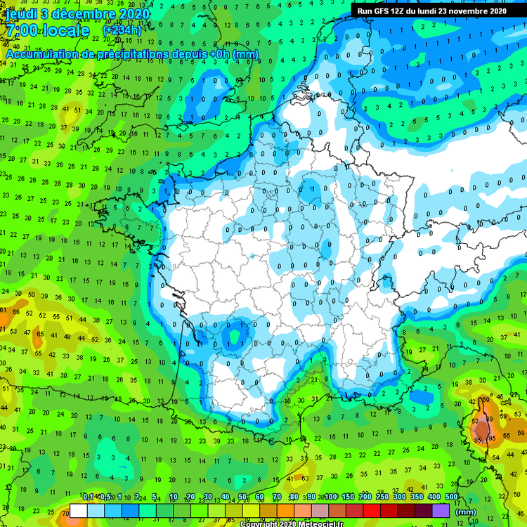
Percentage of November precip so far:  Total precip @ 240 h as per the latest GFS run   |
|
|
|
Post by 🖕🏿Mörön🖕🏿 on Nov 24, 2020 11:40:21 GMT -5
Big snows in HV-GB, NL
|
|
Deleted
Deleted Member
Posts: 0
|
Post by Deleted on Nov 24, 2020 11:47:48 GMT -5
🖕🏿Mörön🖕🏿 holy crap! Part of me actually wants to see something like that around here this winter.
|
|
|
|
Post by 🖕🏿Mörön🖕🏿 on Nov 24, 2020 12:32:14 GMT -5
🖕🏿Mörön🖕🏿 holy crap! Part of me actually wants to see something like that around here this winter. It could happen here (and it has), just not that likely. But, if it's going to happen, it would be this year due to the strong La Niña conditions. |
|
|
|
Post by AJ1013 on Nov 24, 2020 15:32:27 GMT -5
GFS starting from November 29th here:
79/72
72/57
57/45
62/41
72/48
60/42
64/45
66/46
72/50
69/52
70/53
Unreal if this happens. Anything close to this would be awesome!
|
|
|
|
Post by rozenn on Nov 24, 2020 17:26:09 GMT -5
Btw this stalled warm from over Channel is killing me. Today's lows: Yesterday  2 days ago   Adding to the fray...  |
|
|
|
Post by Steelernation on Nov 25, 2020 2:52:19 GMT -5
3.9" (10 cm) of snow fell here in Boulder this morning. Seems like more fell, a lot melted with temps in the low 40s and sun and there's still a couple inches on the ground.
Back home, this was a cold rain event with 0.37" of precipitation yet only a trace of snow there. Interesting set up, Boulder gets significantly more snow but it's unusual to have all snow in Boulder and all rain in Fort Collins--typically both would get the same precipitation type, just more here.
|
|
|
|
Post by ral31 on Nov 25, 2020 11:55:35 GMT -5
Line of storms came through early this morning. Saw a tornado warning to my south. Looks like Thanksgiving Day will be sunny with mid 70's, then could get quite a bit of rain Fri-Sun with a stalling frontal system.
Coolest temps of the season coming next week with first freeze of the season looking likely.
|
|
|
|
Post by ral31 on Nov 25, 2020 16:09:23 GMT -5
High cold probabilities for the Deep South next week!  |
|
|
|
Post by Benfxmth on Nov 25, 2020 16:24:37 GMT -5
High cold probabilities for the Deep South next week!  Temperatures look more typical of an El Niño winter, though it looks like precipitation will remain below normal except near the east coast.  |
|