|
|
Post by Nidaros on Dec 27, 2020 9:07:03 GMT -5
Very impressive cold last night. At the same time as it was -43C in Coavddatmohkki, it was 7c along the coast near Ålesund (Vigra, Ona etc), so a range of more than 50c. Not many countries in Europe can see such a temperature range in lowland areas at exactly the same time. Can think of Russia and probably Sweden besides Norway, not sure if Finland can do that range. |
|
|
|
Post by rozenn on Dec 27, 2020 11:07:14 GMT -5
Very impressive cold last night. At the same time as it was -43C in Coavddatmohkki, it was 7c along the coast near Ålesund (Vigra, Ona etc), so a range of more than 50c. Not many countries in Europe can see such a temperature range in lowland areas at exactly the same time. Can think of Russia and probably Sweden besides Norway, not sure if Finland can do that range. Britain does, when Lerwick is still basking in polar air while London is hotter than India. |
|
|
|
Post by Nidaros on Dec 27, 2020 11:14:31 GMT -5
At the same time as it was -43C in Coavddatmohkki, it was 7c along the coast near Ålesund (Vigra, Ona etc), so a range of more than 50c. Not many countries in Europe can see such a temperature range in lowland areas at exactly the same time. Can think of Russia and probably Sweden besides Norway, not sure if Finland can do that range. Britain does, when Lerwick is still basking in polar air while London is hotter than India. And according to first class sources like this, that happens very often!  For now an extreme snow event is expected in Britain, as we can read about in that very reliable source. |
|
|
|
Post by Benfxmth on Dec 27, 2020 13:13:03 GMT -5
Christmas hailstorm in Parma, with slow-moving frontal thunderstorms.
|
|
|
|
Post by nei on Dec 27, 2020 13:15:03 GMT -5
rain on snow caused a big spike in water levels, well above normal for this time of year (usually on the low side this year). northern New Hampshire river; drains most of the White Mountains  unusually dry summer there, you can series no recovery and long decline after early July thunderstorms. Conneticut River near here drained a large area, some of which got summer storms so had some late summer recovery. Similar recent spike even though it's a much larger river  Green River, little very shallow river, gauge is 10 miles north of me  river warms up to about 80°F on hot summer days; river is mostly shaded, a sun exposed river might reach closer to the air temperature max (high 80s for weeklong stretches). So rivers in the shade have a mean temperature about the daily mean and max temperature a few degrees cooler than daily max  |
|
|
|
Post by nei on Dec 27, 2020 13:18:08 GMT -5
At the same time as it was -43C in Coavddatmohkki, it was 7c along the coast near Ålesund (Vigra, Ona etc), so a range of more than 50c. Not many countries in Europe can see such a temperature range in lowland areas at exactly the same time. Can think of Russia and probably Sweden besides Norway, not sure if Finland can do that range. [/quote] That's a distance of 1100 km /700 miles. Probably could find a 50°C range in British Columbia in winter occasionally, but its geography is rather similar (though inland mostly an elevated plateau). What was inland Norway at Alesund's latitude like (such as Dombås or Oppdal)? |
|
|
|
Post by Nidaros on Dec 27, 2020 13:39:10 GMT -5
At the same time as it was -43C in Coavddatmohkki, it was 7c along the coast near Ålesund (Vigra, Ona etc), so a range of more than 50c. Not many countries in Europe can see such a temperature range in lowland areas at exactly the same time. Can think of Russia and probably Sweden besides Norway, not sure if Finland can do that range. That's a distance of 1100 km /700 miles. Probably could find a 50°C range in British Columbia in winter occasionally, but its geography is rather similar (though inland mostly an elevated plateau). What was inland Norway at Alesund's latitude like (such as Dombås or Oppdal)?[/quote] Not very cold there, Dombås a low of -4.9C at that hour. Larger range internally in the far north, Torsvåg high -5.4C at the coast NW of Coavdathmohkki at the same time. |
|
|
|
Post by rozenn on Dec 27, 2020 15:02:48 GMT -5
Storm Bella brought high winds to the region: 96 km/h @ Paris-Montsouris 98 km/h @ CDG airport 146 kmh/h @ the top of the Eiffel tower Some minor damage, like on this suburban train line: 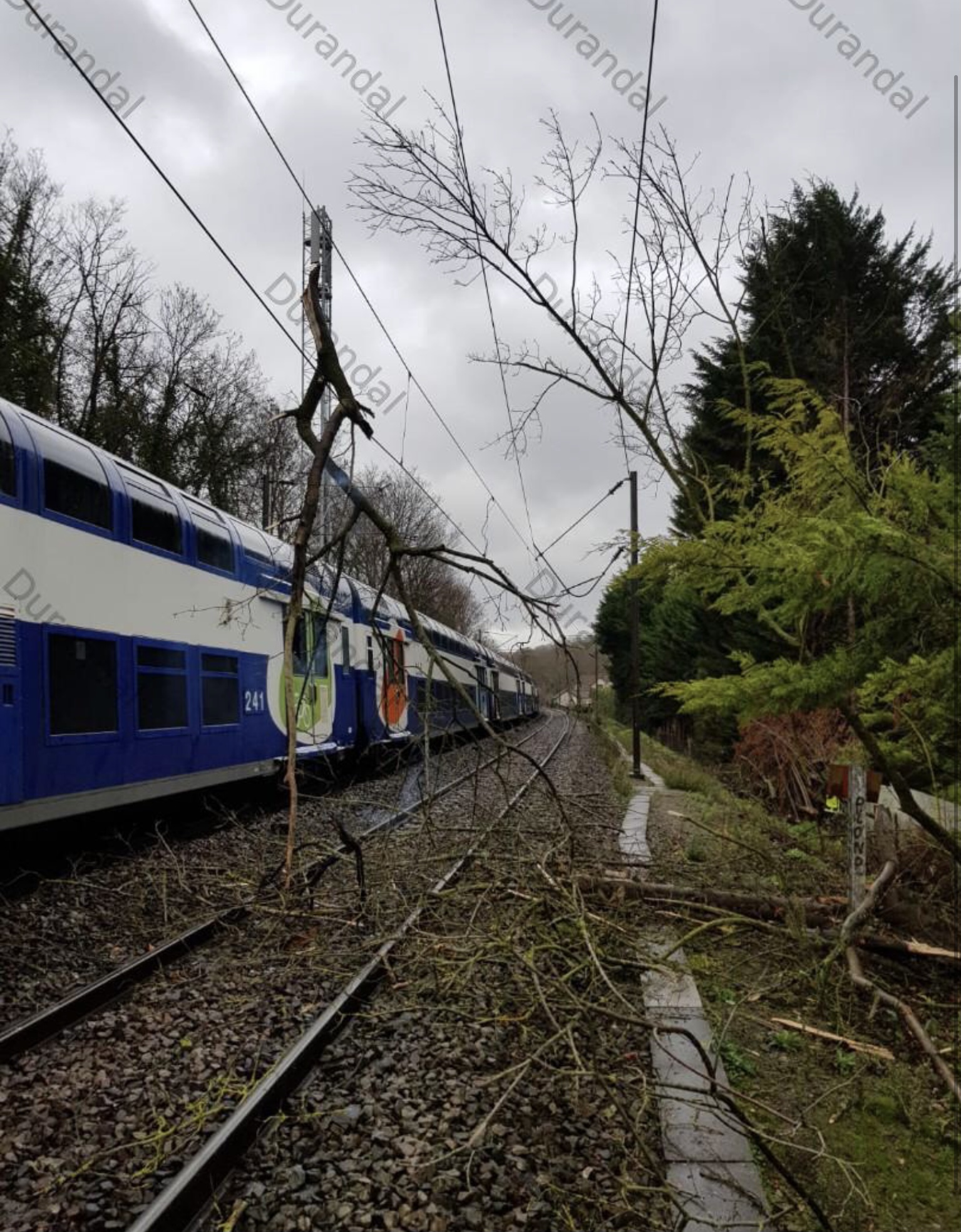 Hoping for some snowflakes tomorrow: 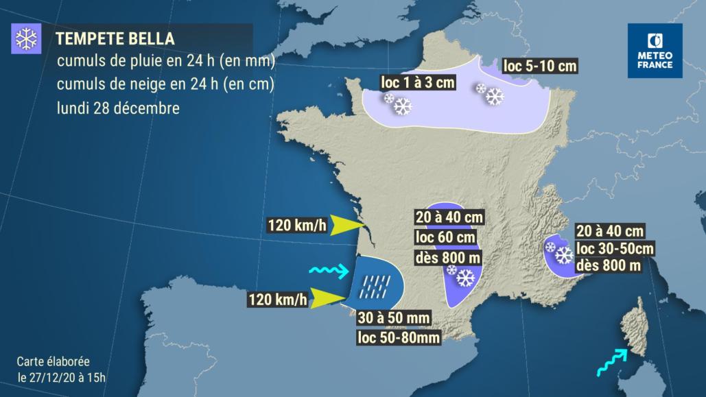 |
|
|
|
Post by Donar on Dec 27, 2020 16:00:47 GMT -5
Disappointing lows this morning, I was in that green bubble surrounded by below freezing temps. Nevertheless it felt very cold today, about 3 °C and strong wind when I was outside.
|
|
|
|
Post by Benfxmth on Dec 27, 2020 19:29:17 GMT -5
@josecanyousee97
|
|
|
|
Post by bizzy on Dec 27, 2020 19:38:28 GMT -5
January looking to begin on a milder note, I’m hoping that doesn’t change.
The cold and snow lovers have already begun to panic.
|
|
|
|
Post by Benfxmth on Dec 27, 2020 19:42:23 GMT -5
January looking to begin on a milder note, I’m hoping that doesn’t change. The cold and snow lovers have already begun to panic. Here are the CPC maps of forecast medium-range temperature probabilities. You're very likely to have above-average temps for the first week of January.   |
|
|
|
Post by chesternz on Dec 28, 2020 2:26:31 GMT -5
Christchurch had some miserable Xmas weather. Only one decent high and most days below 20 C plus rain every day. Only proberly sub-polar climates see this kind of weather in mid-Summer  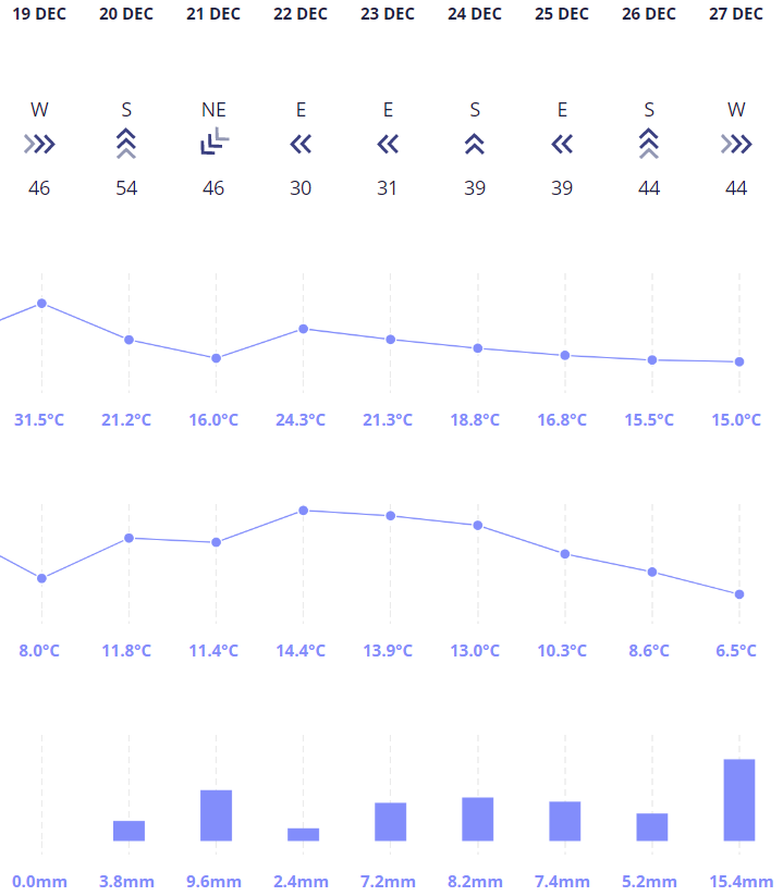 |
|
|
|
Post by Ariete on Dec 28, 2020 5:10:37 GMT -5
At the same time as it was -43C in Coavddatmohkki, it was 7c along the coast near Ålesund (Vigra, Ona etc), so a range of more than 50c. Not many countries in Europe can see such a temperature range in lowland areas at exactly the same time. Can think of Russia and probably Sweden besides Norway, not sure if Finland can do that range.
When it was -40C in Utsjoki, it was 5C in Lemland, so a 45C range for Finland.
|
|
|
|
Post by Beercules on Dec 28, 2020 5:39:34 GMT -5
Check this shit out. Unbelievable, unthinkable, absurd, beyond all reality levels of cold this morning in SE Sth Aus. 28th Dickcember 2020.  |
|
|
|
Post by jgtheone on Dec 28, 2020 6:00:58 GMT -5
What on earth is going on here? 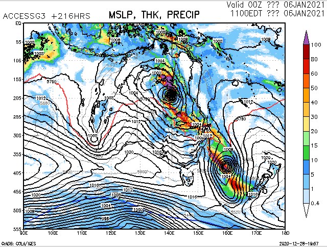 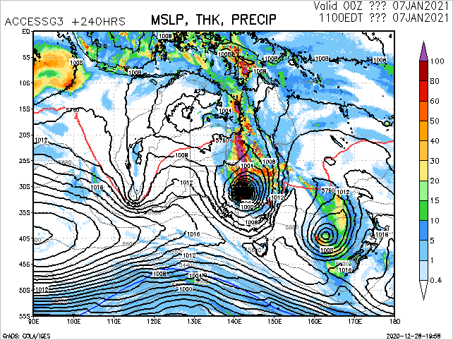 |
|
|
|
Post by urania93 on Dec 28, 2020 6:11:14 GMT -5
Snowy weather conditions over the most of north Italy between the last night and this morning, with cold enough temperatures to allow accumulation on the ground not just in the elevated areas, but also in large parts of the Po valley (in particular over Lombardy) or in Liguria.  ^ temperature map for this morning at 7 am 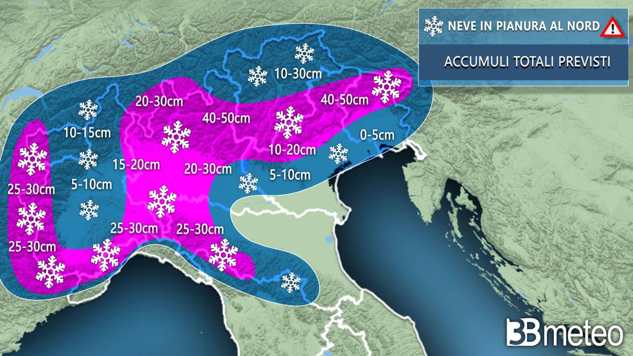 ^ approximative map showing the predicted snow amounts ref ^ Milan city center, in some parts of the city the snow accumulation is quire remarkable Some snow also along the Liguria coast, that's quite uncommon as well /https%3A//www.ilsecoloxix.it/image/contentid/policy%3A1.39707141%3A1609150815/celle5.jpeg%3Ff%3Ddetail_558%26h%3D720%26w%3D1280%26%24p%24f%24h%24w%3Db65bad1) This is from Celle Ligure, west of Genoa. |
|
|
|
Post by knot on Dec 28, 2020 6:22:42 GMT -5
What on earth is going on here?   Far king oath, this had better happen! That's one hell of a low. |
|
|
|
Post by Benfxmth on Dec 28, 2020 7:30:20 GMT -5
@josecanyousee97 I'll tag you from here – NWS is still forecasting ~5" of snow for Wednesday night, though with the possibility of freezing drizzle Thursday morning
|
|
Deleted
Deleted Member
Posts: 0
|
Post by Deleted on Dec 28, 2020 8:35:02 GMT -5
Benfxmth those maps are much, much more optimistic than my local TV station (WBAY-TV), which doesn't have a precipitation chance above 40% for Tuesday, Wednesday, or Thursday 
|
|