|
|
Post by srfoskey on Apr 4, 2021 0:15:05 GMT -5
Warmer and drier than normal, but nothing to write home about. It was quite a shift from the brutally cold February we had.   |
|
|
|
Post by Babu on Apr 5, 2021 7:24:50 GMT -5
Airport  Uni rooftop patio:  No snow around the uni area affecting the highs quite a lot on the warmest days. It was a mild March. Had there not been 200kg/m2 of snow at the start of the month it would've likely lost its snow cover quite early and become warmer and very springlike. Pretty dry and average sunshine. Pretty bipolar though and a cold snap early in the month brought down the average a lot. The second half averaged 4.7'C highs and -3.7'C lows at the airport, a 0.7'C 24h mean, and the last five days of the month all had lows above freezing at the airport which is impressive considering some of them had clear night skies. Notable is that while the max temp was only 8.6, below average, 4 days had highs of 8.5'C or warmer. So 4 days were within 0.1'C of the max temp. At one point three days in a row had the following highs: 8.6, 8.5, 8.5. Lows stayed within 1.5'C of eachother as well. Temps vs 1991-2020 (2011-2020) Average high: +1.4 (+0.5)-6.8/2.4 Average low: +2.5 (+1.8) Average mean: +2.0 (+1.1) Precipitaiton vs 91-20: About 50% (figures are only estimated as of now, for February as well as March) Sunshine vs 02-18 (11-20): 98% (91%). I'll update to 91-20 figures when SMHI release the monthly summary which includes normals, presumably tomorrow |
|
|
|
Post by Speagles84 on Apr 5, 2021 7:31:41 GMT -5
Airport  Uni rooftop patio:  No snow around the uni area affecting the highs quite a lot on the warmest days. It was a mild March. Had there not been 200kg/m2 of snow at the start of the month it would've likely lost its snow cover quite early and become warmer and very springlike. Pretty dry and average sunshine. Pretty bipolar though and a cold snap early in the month brought down the average a lot. The second half averaged 4.7'C highs and -3.7'C lows at the airport, a 0.7'C 24h mean, and the last five days of the month all had lows above freezing at the airport which is impressive considering some of them had clear night skies. Notable is that while the max temp was only 8.6, below average, 4 days had highs of 8.5'C or warmer. So 4 days were within 0.1'C of the max temp. At one point three days in a row had the following highs: 8.6, 8.5, 8.5. Lows stayed within 1.5'C of eachother as well. Temps vs 1991-2020 (2011-2020) Average high: +1.4 (+0.5)-6.8/2.4 Average low: +2.5 (+1.8) Average mean: +2.0 (+1.1) Precipitaiton vs 91-20: About 50% (figures are only estimated as of now, for February as well as March) Sunshine vs 02-18 (11-20): 98% (91%). I'll update to 91-20 figures when SMHI release the monthly summary which includes normals, presumably tomorrow 5.42" of precip in January with a max temperature of 35F          That is extremely impressive for Umea |
|
|
|
Post by Babu on Apr 5, 2021 7:50:23 GMT -5
Airport  Uni rooftop patio:  No snow around the uni area affecting the highs quite a lot on the warmest days. It was a mild March. Had there not been 200kg/m2 of snow at the start of the month it would've likely lost its snow cover quite early and become warmer and very springlike. Pretty dry and average sunshine. Pretty bipolar though and a cold snap early in the month brought down the average a lot. The second half averaged 4.7'C highs and -3.7'C lows at the airport, a 0.7'C 24h mean, and the last five days of the month all had lows above freezing at the airport which is impressive considering some of them had clear night skies. Notable is that while the max temp was only 8.6, below average, 4 days had highs of 8.5'C or warmer. So 4 days were within 0.1'C of the max temp. At one point three days in a row had the following highs: 8.6, 8.5, 8.5. Lows stayed within 1.5'C of eachother as well. Temps vs 1991-2020 (2011-2020) Average high: +1.4 (+0.5)-6.8/2.4 Average low: +2.5 (+1.8) Average mean: +2.0 (+1.1) Precipitaiton vs 91-20: About 50% (figures are only estimated as of now, for February as well as March) Sunshine vs 02-18 (11-20): 98% (91%). I'll update to 91-20 figures when SMHI release the monthly summary which includes normals, presumably tomorrow 5.42" of precip in January with a max temperature of 35F          That is extremely impressive for Umea Places nearby just a little farther inland were significantly wetter. Nordanbäck (1), Vännäs (2) and Tavelsjö (3):     And Umeå for reference:  Vännäs reached a maximum snow depth of 126cm, Tavelsjö 122cm and Nordanbäck 115cm, all in January. Umeå never recorded more than 75cm in January. Managed to reach 81cm in February though. |
|
|
|
Post by kronan on Apr 5, 2021 9:45:37 GMT -5
 1.1C above the 1991-2020 average. precipitation around normal. wasn't any real warmth to speak of, though. since the highest temperature was below the mean maximum. ........   |
|
|
|
Post by jgtheone on Apr 7, 2021 1:23:31 GMT -5
|
|
|
|
Post by Cadeau on Apr 7, 2021 9:26:16 GMT -5
Reykjavík, Iceland March 2021  |
|
|
|
Post by Crunch41 on Apr 12, 2021 22:57:41 GMT -5

March was warm and dry. 6.5F/3.6C above normal, 1.43"/36.3mm drier than normal. The dry and warm streak from late February continued and reached 20 days without measurable rainfall. Then it snowed on the 15th, the only snow of the month, and a few days had light rain after that. No ice days, no days more than a few degrees below average.
The dry and warm March meant that the muddy season in spring was short even though snow depth was very high in February. It's nice since a wet March can be a muddy mess.
February 1-22 averaged 15.0F with 1.19" precip and 15.5" snow (13.5 through the 20th)
February 21-28 averaged 37.1F with a trace of precip << Spring thaw started here.
March 1-14 averaged 40.0F with a trace of precip March 15-31 averaged 42.7F with 0.84" precip and 0.8" snow
The one snowy day ruined the "perfect" snow cover. The first snow depth was reported on December 29th, then it stayed until March 7th. Then it snowed enough to report a depth of 1" on the 16th. I don't know if a winter has ever had the snow depth all in one continuous block.
Most winters here have a thaw at some point as well as some early or late snow storms that melt quickly. This seems most likely to happen in very cold or snowy places that always have a constant snowpack in winter. If they got a big storm early, then the snow lasted until late spring or early summer, it could happen. Or it happens in places that only saw snow once that winter, I guess. |
|
|
|
Post by Cadeau on Apr 16, 2021 11:55:48 GMT -5
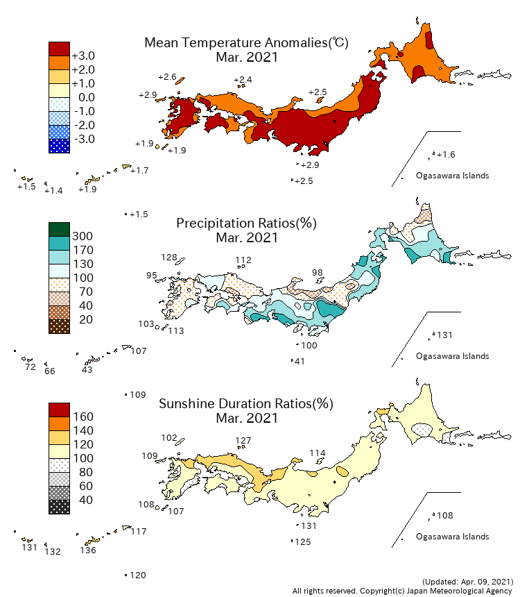
▼ <Monthly Climate Anomaly over Japan>

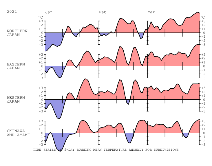
▼ <Time Series of Temperature Anomaly>

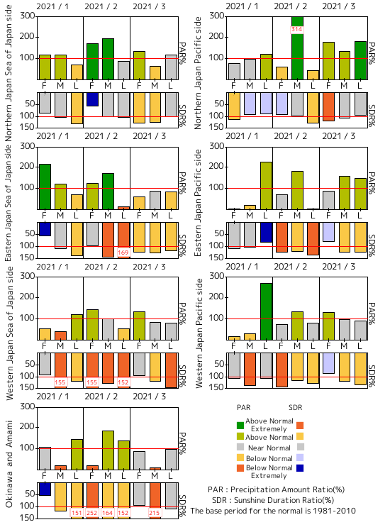
▼ <Time Series of 10days Precipitation Amount Ratio and Sunshine Duration Ratio>

▼ <10-day Mean Sea Level Pressure>
▼ <10-day Mean 850hPa Temperature>
▼ <10-day Mean 500hPa GeoPotential Height>
▼ <10-day Mean Outgoing Longwave Radiation>
|
|