|
|
Post by ilmc90 on Aug 28, 2021 14:12:14 GMT -5
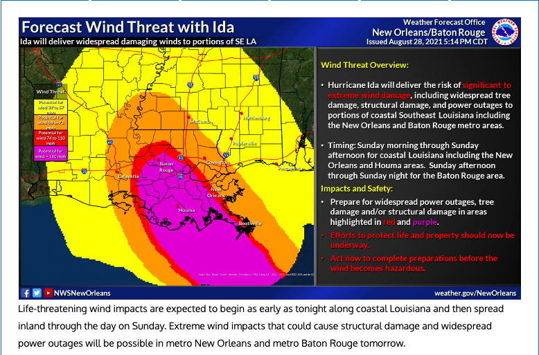
Current forecast wind map. I'm in the potential for 58-73 mph zone. Had 80-90 mph wind here during Laura last year.  Crazy wind threat well-inland into Mississippi. |
|
|
|
Post by ral31 on Aug 28, 2021 14:33:34 GMT -5
Current forecast wind map. I'm in the potential for 58-73 mph zone. Had 80-90 mph wind here during Laura last year. Crazy wind threat well-inland into Mississippi. Shows 110 mph around as far inland as Laura had.  |
|
|
|
Post by ral31 on Aug 28, 2021 14:42:00 GMT -5
Models in pretty good agreement.  |
|
|
|
Post by desiccatedi85 on Aug 28, 2021 19:46:11 GMT -5
High/low of 80/68 and overcast (no rain) with an easterly flow today, very comfortable
|
|
|
|
Post by ilmc90 on Aug 29, 2021 6:31:36 GMT -5
Been a very dull, cloudy weekend but no complaints. Getting a nice break from the heat and the sun. 67 F/19 C at 7AM...today should be a little warmer than yesterday with a forecast high of 77 F/25 C.
|
|
|
|
Post by FrozenI69 on Aug 29, 2021 6:35:39 GMT -5
Nice sleeping weather yesterday night at my parents place with lows in the 60’s F. Didn’t need A/C. Comfortable day today for August, 79/64
|
|
|
|
Post by alex992 on Aug 29, 2021 7:03:14 GMT -5
Louisiana looks like it's in for a battering from Ida. Cat 4, and potential for Cat 5 at landfall. Fuck!! It's strengthened to a Cat 4 as of 4 AM:  Category 3+ (110+ mph) winds impacting both New Orleans and Baton Rouge:  Could definitely be a Category 5 by landfall. Very scary situation for that region, it's basically another Katrina... |
|
|
|
Post by ral31 on Aug 29, 2021 8:27:25 GMT -5
Louisiana looks like it's in for a battering from Ida. Cat 4, and potential for Cat 5 at landfall. Fuck!! It's strengthened to a Cat 4 as of 4 AM:  Category 3+ (110+ mph) winds impacting both New Orleans and Baton Rouge:  Could definitely be a Category 5 by landfall. Very scary situation for that region, it's basically another Katrina... Yeah looks quite scary for SE Louisiana... I think the surge/flooding isn't expected to be as bad for New Orleans compared to Katrina. With Katrina the storm went east of New Orleans which pushed the surge in from Lake Pontchartrain. The threat seems to be lessening for me. Hurricane force winds have been trimmed back in NWS's latest map and don't even extend into MS. |
|
|
|
Post by FrozenI69 on Aug 29, 2021 11:09:51 GMT -5
Almost category 5 now. Wind speeds of 150 mph reported. Holy crap 😮
|
|
|
|
Post by Benfxmth on Aug 29, 2021 15:29:25 GMT -5
|
|
|
|
Post by AJ1013 on Aug 29, 2021 17:43:02 GMT -5
It’s what you want. Cool and wet for here after tomorrow.
|
|
|
|
Post by nei on Aug 29, 2021 20:53:14 GMT -5
Lousiana maded handsome warm blowing rain
|
|
|
|
Post by nei on Aug 29, 2021 22:06:00 GMT -5
Looks bad; South Lake Tahoe may burn
|
|
|
|
Post by AJ1013 on Aug 29, 2021 22:13:18 GMT -5
Storms missed me today, looked pretty though.
|
|
|
|
Post by desiccatedi85 on Aug 29, 2021 22:22:51 GMT -5
High/low of 76/68 today with humid overcast conditions, but thankfully no rain.
80s next couple of days, mid-week rain from Ida remnants, then looks like a typical stable upper 70s September pattern with dry weather.
|
|
|
|
Post by nei on Aug 30, 2021 6:28:01 GMT -5
|
|
|
|
Post by nei on Aug 30, 2021 11:58:29 GMT -5
moron for driving in the hurricane
|
|
|
|
Post by nei on Aug 30, 2021 12:10:20 GMT -5
good comparison of the size of the two storms; Katrina was larger but weaker in the center at landfall. Katrina had a higher peak intensity before landfall and churned up the ocean more  |
|
|
|
Post by AJ1013 on Aug 30, 2021 15:17:13 GMT -5
NWS going for a whopping 3-4" here. I don't think we'll get quite that much
/photo/2
|
|
|
|
Post by trolik on Aug 30, 2021 17:09:55 GMT -5
it will be interesting to see the storm surge totals after damage is assessed, the last forecast before landfall was up to 16ft along a section of southeastern LA
|
|