|
|
Post by Doña Jimena on Jan 17, 2022 3:00:17 GMT -5
Not as windy as in Finno-Ugric countries, but still stormy, damages expected especially in Riga and central Latvia with NW wind gusts up to 32 meters per second:  |
|
|
|
Post by Doña Jimena on Jan 17, 2022 5:09:36 GMT -5
|
|
|
|
Post by Beercules on Jan 17, 2022 5:28:05 GMT -5
Volcanic material over QLD and NT today  |
|
|
|
Post by jgtheone on Jan 17, 2022 5:49:40 GMT -5
If you told me this would be a forecast even last week I would have laughed in your face  |
|
|
|
Post by Beercules on Jan 17, 2022 6:10:59 GMT -5
Mine's been upgraded, I'm liking this  Warmer than outback SA, look at all that rain  |
|
|
|
Post by Marcelo on Jan 17, 2022 8:00:37 GMT -5
The heatwave in Buenos Aires is finally over. It’s still ongoing in Northeastern Argentina and Southern Brazil. Even though extreme, here it was rather tame compared to many places in Central Argentina, both in absolute and relative terms.
Last week in Buenos Aires: Jan 10: 23.3C/ 34.4CJan 11: 25.5C/ 41.1C (#3 highest temperature on record… it was #2 for a couple of days) Jan 12: 21.8C/ 33.8CJan 13: 23.5C/ 36.6CJan 14: 26.0C/ 41.5C (#2 highest temperature on record) Jan 15: 30.0C/ 38.8C (Highest daily low on record, thrashed previous one which was “only” 28.2C) Jan 16: 22.2C/ 33.0CMar del Plata broke its all-time high: 42.4C (previous record was 41.6 in 1957) La Plata broke its all-time high: 41.0C (previous record was 39.9C in 1995) Tandil broke its all-time high: 40.7C (previous record was 39.9C in 1957) Necochea reached 43.2C (the station didn’t exist back in 1957, but I doubt it had got that hot) Córdoba didn’t reach its all-time high, but had 5 days hitting over 40C, which was unheard. Top all-time highs in Buenos Aires 1) Jan 29, 1957: 43.3C 2) Jan 14, 2022: 41.5C3) Jan 11, 2022: 41.1C4) Jan 31, 1935: 40.5C - Dec 18, 1995: 40.5C 6) Jan 18, 1943: 40.3C 7) Jan 24, 1923: 40.0C 8) Jan 6, 1925: 39.7C - Jan 9, 1955: 39.7C 10) Feb 5, 1877: 39.5C* - Jan 30, 1934: 39.5C - Jan 9, 1957: 39.5C - Jan 27, 1957: 39.5C Top all-time highest lows in Buenos Aires1) Jan 15, 2022: 30.0C2) Dec 30, 1971: 28.2C - Jan 23, 2014: 28.2C 4) Dec 29, 1971: 28.1C 5) Jan 27, 1990: 28.0C 6) Mar 21, 1980: 27.7C 7) Jan 31, 2003: 27.6C - Jan 9, 1977: 27.6C 9) Feb 2, 1900: 27.5C* 10) Jan 18, 2014: 27.4C
* Old station in different location.
|
|
|
|
Post by alex992 on Jan 17, 2022 10:15:07 GMT -5
17 F (-8.3 C) and cloudy here just after 9 AM, after a morning low of 11 F (-11.7 C), today's predicted high is 30 F (-1.1 C) with cloudy skies. Might have some snow showers and flurries today, we did yesterday (got some huge flakes at one point) but with minimal accumulation.
|
|
|
|
Post by Doña Jimena on Jan 17, 2022 10:23:12 GMT -5
Wind gusts have reached 27.7 meters per second in Riga, the strongest wind since January 2005.  Temperature in Riga has fallen from 4C to -1C. |
|
|
|
Post by nei on Jan 17, 2022 12:08:44 GMT -5
impressive surf as the storm pulled out
|
|
|
|
Post by Ariete on Jan 17, 2022 15:54:19 GMT -5
Quite the fizzer here. Highest gust at Artukainen was 21 m/s, at the same time as that Kumlinge gust was recorded (around 7:00). At noon gusts were down to around 11-13 m/s. The storm stayed mostly at sea.
|
|
|
|
Post by desiccatedi85 on Jan 17, 2022 17:43:36 GMT -5
Storm has wrapped up here. Today had a high/low of 46/38 here, with a bit of snow falling last night (0.6") which was quickly all washed away as precipitation switched to rain. Recorded 1.56" of total precipitation, maximum sustained winds got into 32mph last night, with wind gusts on the south shore of LI reaching as high as 69mph. Awoke to the sound of thunder at about 4am this morning, and there was a severe thunderstorm warning issued for much of NYC, don't remember the last time there were severe thunderstorms here in January! All in all an epic blast of January weather. |
|
|
|
Post by greysrigging on Jan 17, 2022 17:55:52 GMT -5
It's Going To Be A Wet Week In Australia ( source: Weatherzone ) Rain and thunderstorms will affect a large portion of Australia this week as the remnants of Tropical Cyclone Tiffany spread tropical moisture across the country. Tropical Cyclone Tiffany made landfall over the eastern Top End in the middle of last week before weakening below cyclone strength as it moves over land. Since then, the former tropical cyclone has caused widespread and heavy rain over the Top End and Kimberley. Rain and thick clouds are now spreading over central and southern Australia as Ex-Tropical Cyclone Tiffany moves over the Red Centre.  Image: Composite visible/infrared satellite image captured at 3pm AEDT on Monday, showing Ex-Tropical Cyclone Tiffany near the junction of the WA/NT/SA borders. The tropical moisture brought over Australia by Tiffany will help fuel rain over part of every mainland state and territory this week. Over the week as a whole, widespread falls of 15-30mm are likely. Some areas of SA, NSW, QLD and the NT should see more than 50mm and could have isolated areas that pick up over 100mm.  Some of this week’s rain is likely to cause flash flooding, while riverine flooding is also possible if the rain falls over already saturated catchments. In addition to the rain, the tropical moisture will also limit solar power generation in several states and bring some welcome relief from the summer heat, particularly over the interior. However, areas in southern Australia that don’t see thick clouds or heavy rain this week could still be quite warm and humid. Melbourne and Adelaide are both forecast to reach the high-twenties to mid-thirties between Wednesday and Sunday. Looks stormy over the New England Ranges, north eastern NSW  |
|
|
|
Post by Ariete on Jan 17, 2022 19:42:35 GMT -5
CFSv2 is suggesting a mild end to winter for Northern Europe and a nice start for spring in most of Europe:
|
|
|
|
Post by ilmc90 on Jan 17, 2022 19:46:27 GMT -5
Freeze Warnings and Frost Advisories in Southeast GA and Northeast Florida (inland away from the coast).
|
|
|
|
Post by rpvan on Jan 17, 2022 21:46:36 GMT -5
25-40cm of snow fell across the GTA (Greater Toronto Area) yesterday into this afternoon and crippled the entire city.
|
|
|
|
Post by desiccatedi85 on Jan 17, 2022 21:57:15 GMT -5
|
|
|
|
Post by nei on Jan 17, 2022 23:27:16 GMT -5
lake champlain effect snow with the slope of the Greens helping
|
|
|
|
Post by Benfxmth on Jan 18, 2022 0:49:14 GMT -5
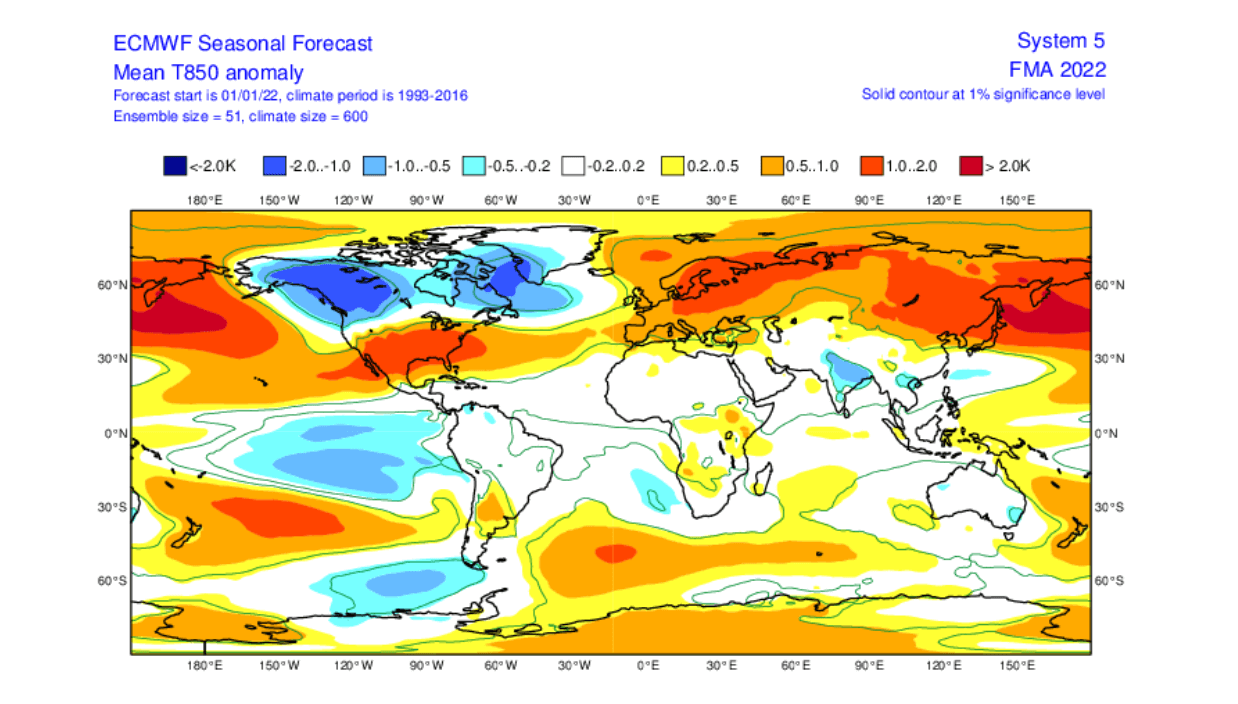
CFSv2 is suggesting a mild end to winter for Northern Europe and a nice start for spring in most of Europe: ECMWF isn't looking bad either—keep the cold off Gayrope and the U.S. South:   |
|
|
|
Post by Benfxmth on Jan 18, 2022 0:54:38 GMT -5
Snowfall totals as of 10 AM ET Monday
|
|
|
|
Post by rpvan on Jan 18, 2022 1:29:29 GMT -5
CFSv2 is suggesting a mild end to winter for Northern Europe and a nice start for spring in most of Europe: ECMWF isn't looking bad either—keep the cold off Gayrope and the U.S. South:   Looks promising! Perhaps we'll see another round of cold/snow here in Vancouver in February after the warm January. |
|