|
|
Post by srfoskey on Jan 30, 2022 14:13:00 GMT -5
I don't feel like sharing model graphics just yet, but there's potential for something interesting on Wednesday.
|
|
|
|
Post by greysrigging on Jan 30, 2022 16:13:16 GMT -5
Bureau of Meteorology "Days of torrential rain and thunderstorms over the tropical north and central Australia are set to continue due to the presence of the monsoon trough. Flood Watches are current for large parts of northern Western Australia, inland Northern Territory, western Queensland and inland South Australia. A Severe Weather Warning for heavy rain and damaging winds has been issued for the western Kimberley, which takes in Broome. A Severe Weather Warning has also been issued for damaging winds about the western Top End, including Darwin. Showers and thunderstorms will become more widespread and tend to rain areas as the monsoon trough and an associated low pressure system deepen. This inland monsoon low will move west early this week, causing heavy rain to build across parts of the Kimberley, and extend into SA. Large rainfall totals of 50-150mm are likely, increasing to 150-250mm with intense thunderstorms. Increased water ponding and overland flow together with rises in local streams and creeks can be expected. Transport routes may be further disrupted, affecting community access and travel and compounding already significant community impacts".     |
|
|
|
Post by Steelernation on Jan 31, 2022 0:11:11 GMT -5
56/12 today (13/-11 c), high diurnal and the warmest temp of the month. Still will have the lowest January max since 2010 unless tomorrow gets warmer.
|
|
|
|
Post by tommyFL on Jan 31, 2022 0:45:00 GMT -5
Key West and Marathon both had their first sub-60 F max temps since 2010, with highs of 59 F (15 C) and 57 F (14 C), respectively.
|
|
|
|
Post by greysrigging on Jan 31, 2022 2:12:36 GMT -5
Key West and Marathon both had their first sub-60 F max temps since 2010, with highs of 59 F (15 C) and 57 F (14 C), respectively. That is chilly for the Tropics... ( oh wait on, gets out Atlas re Tropic of Cancer.... ) Haha, for the record I regard southern Florida as 'tropical'.... |
|
|
|
Post by greysrigging on Jan 31, 2022 2:54:40 GMT -5
Monsoon Squalls And Heavy Rain Hit Northern Australia ( source: Weatherzone )  A burst of monsoonal rain, wind and storms is lashing northern Australia this week, while the threat of multiple tropical cyclones lingers in the east and west. The satellite image below shows clouds covering a vast area of central and northern Australia on Monday morning.  These clouds are being carried across Australia by monsoonal winds that are feeding into multiple low pressure systems and an active monsoon trough. What Is The Monsoon Trough? The term 'monsoon trough' simply refers to the leading edge of moisture-laden west to northwesterly winds that develop over northern Australia during the wet season. This deep layer of persistent west to northwesterly winds affect northern Australia periodically during the monsoon season, which runs from about December until March. This is typically the wettest part of the north Australian wet season, which occurs between about November and April. During active periods of the monsoon, air flows from the Indian Ocean and southern Asia towards Australia, where is fuels widespread rain and storms. The monsoon is currently active over Australia. The synoptic chart below shows the position of the monsoon trough and several low pressure systems embedded within it.  The monsoon trough and these embedded lows will cause a dynamic mix of weather over and near Australia this week. The Kimberley And Top End The low pressure system over northwestern Australia is currently causing squally winds and heavy rain in parts of WA and the NT. Broome Airport received 66 mm of rain in 30 minutes on Sunday afternoon and amassed 238 mm during the 24 hours to 9am on Monday. Broome Port also clocked a 91 km/h wind gust in Sunday evening.   Further north, Darwin Airport had a 67 km/h wind gust early on Sunday afternoon. Damaging winds will continue to affect parts of the Kimberley and western Top End on Monday into Tuesday. The strongest winds are likely over the western Kimberley, where destructive gusts above 125 km/h are possible. Heavy rain will also linger near the low, mainly affecting the West Kimberley and North Interior in WA. Daily rainfall totals of 100 to 180 mm are likely on Monday and Tuesday, with isolated daily totals of 200 to 250mm. Two-day accumulated falls of more than 500 mm are possible in the west Kimberley by Tuesday night.  Monsoon rain and thunderstorms will also affect the western Top End and central Australia during the coming days. Severe thunderstorms are possible and warnings will be issued where necessary. The low pressure system is likely to remain over northern WA on Wednesday into Thursday, causing more rain and thunderstorms in the region. Some models suggest that the low could move off Australia's northwest coast on Thursday or Friday, which may give the system a chance of developing into a tropical cyclone. However, at this stage, the low is expected to move towards the west and away from the Australian mainland after it moves offshore. Northern Queensland And The Coral Sea Rain and thunderstorms are also going to affect tropical Queensland this week. While this rain won’t be as heavy as northwestern Australia, weekly accumulated totals could reach 100 to 250mm in some areas.  The satellite images below show a tropical low developing over the northwest Coral Sea on Monday morning, about 500 km off the coast from Cooktown.  This low is in a favourable area for development and has a moderate chance of developing into a tropical cyclone over the coming days. However, there is good model agreement that it will move towards the east away from the Queensland coast during the next several days. Another low pressure located over the southern Coral Sea on Monday morning is moving south into the Tasman Sea. This low won’t have any direct impact on Queensland.  With an active monsoon over Northern Australia, severe weather is a good chance in the tropics this week. Be sure to stay up to date with the latest warnings in your area. |
|
|
|
Post by Ariete on Jan 31, 2022 5:35:49 GMT -5
Finland is now 100% White.
|
|
|
|
Post by Babu on Jan 31, 2022 8:28:31 GMT -5
Finland is now 100% White.
The black finns:  |
|
|
|
Post by Doña Jimena on Jan 31, 2022 10:36:48 GMT -5
Getting whiter in Riga as well. Snow cover has increased from 0 to 8 cm since yesterday afternoon.
|
|
|
|
Post by nei on Jan 31, 2022 12:04:25 GMT -5
been a cold January for northern New England
|
|
|
|
Post by alex992 on Jan 31, 2022 12:24:55 GMT -5
been a cold January for northern New England Been the coldest January since 2014 here, and 3rd coldest since 2000 (only 2009 and 2014 were colder). Very solidly cold month. But just like Burlington, not very notable when considering the whole POR. Only the T-35th coldest January (tied with January 1997). |
|
|
|
Post by srfoskey on Jan 31, 2022 14:19:04 GMT -5
A winter storm watch has been issued for the area. It's the first one of the winter. There's also a significant sleet risk.
|
|
|
|
Post by Morningrise on Jan 31, 2022 18:24:18 GMT -5
Full blown blizzard in Saskatoon today! Winds gusting up to around 80km/h (50 mph) with extremely poor visibility in exposed areas. Snowfall accumulation isn't that high so far but plenty of drifts are forming. Many highways in the southern half of the province are closed. My co-worker who lives in a satellite town about 15 km from Saskatoon is currently stuck at her husband's office in town because she can't get out of the city. Thankfully I live in a central neighbourhood and was able to get home without taking any highways or freeways, and my commute was uneventful. Highway hotline map - red means closed, white means travel not recommended, yellow means winter conditions, black means normal conditions.  |
|
|
|
Post by tommyFL on Jan 31, 2022 19:15:27 GMT -5
Some select min temps throughout the northern Caribbean this morning:
Bahamas:
Freeport, Grand Bahama: 8 C/46 F
Nassau: 14 C/57 F
Cuba:
Bainoa, Mayabeque: 2.8 C/37.0 F
Casablanca, Havana (downtown): 9.7 C/49.5 F
Jose Marti International Airport, Havana: 4 C/39 F
Amistad Cuba-Francia, Isla de la Juventud: 7.4 C/45.3 F
Cienfuegos: 8.8 C/47.8 F
Sancti Spiritus: 8.8 C/47.8 F
Mexico:
Cozumel: 13.2 C/55.8 F
Cancun International Airport: 14 C/57 F
Tizimin, Yucatan: 10.9 C/51.6 F
|
|
|
|
Post by Ethereal on Jan 31, 2022 20:16:38 GMT -5
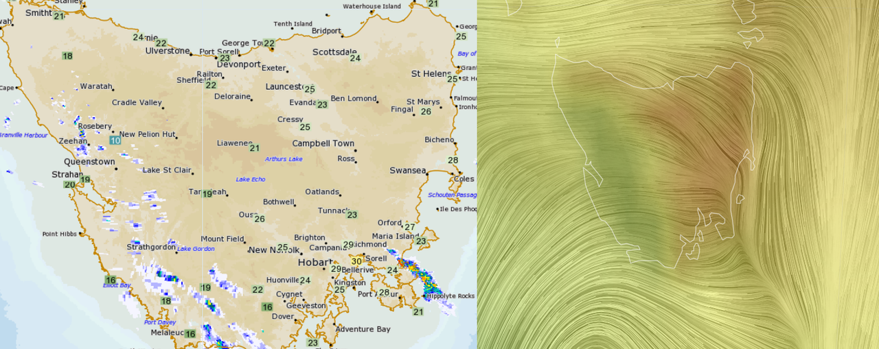
Foehn effect in Tasmania?  |
|
|
|
Post by knot on Jan 31, 2022 20:42:44 GMT -5
Foehn effect in Tasmania?  Obviously. This is a very frequent occurence. |
|
|
|
Post by Ethereal on Jan 31, 2022 20:53:46 GMT -5
The foehn effect seems common in the South Island (NZ) too:  |
|
|
|
Post by jgtheone on Feb 1, 2022 7:55:05 GMT -5
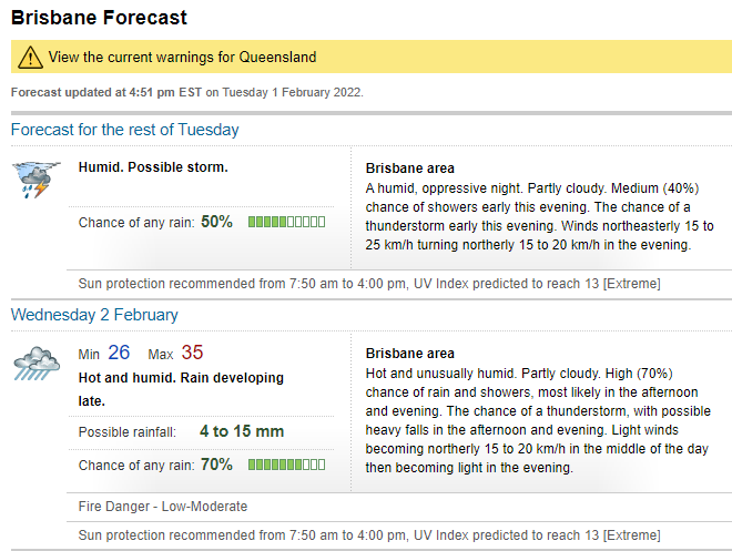
I'd hate to know what "oppressive night" and "unusually humid" means for Brisbane  |
|
|
|
Post by Morningrise on Feb 1, 2022 7:58:56 GMT -5
Nearly all the highways in southeastern Saskatchewan are closed following last night's blizzard. Meanwhile the ones around Saskatoon have re-opened, and we don't appear to have had that much snow accumulation overall (though the drifts that built up from all the wind might be nasty in some places, hopefully my drive to work will be alright this morning).  |
|
|
|
Post by Ethereal on Feb 1, 2022 8:27:50 GMT -5
I'd hate to know what "oppressive night" and "unusually humid" means for Brisbane  The hell? Such descriptions are a first from BOM!  They can might as well add "disturbing" and "brutal" and add an 18+ rating. Lmao! |
|