Deleted
Deleted Member
Posts: 0
|
Post by Deleted on Jun 30, 2022 4:40:03 GMT -5
|
|
|
|
Post by Ariete on Jun 30, 2022 8:34:11 GMT -5
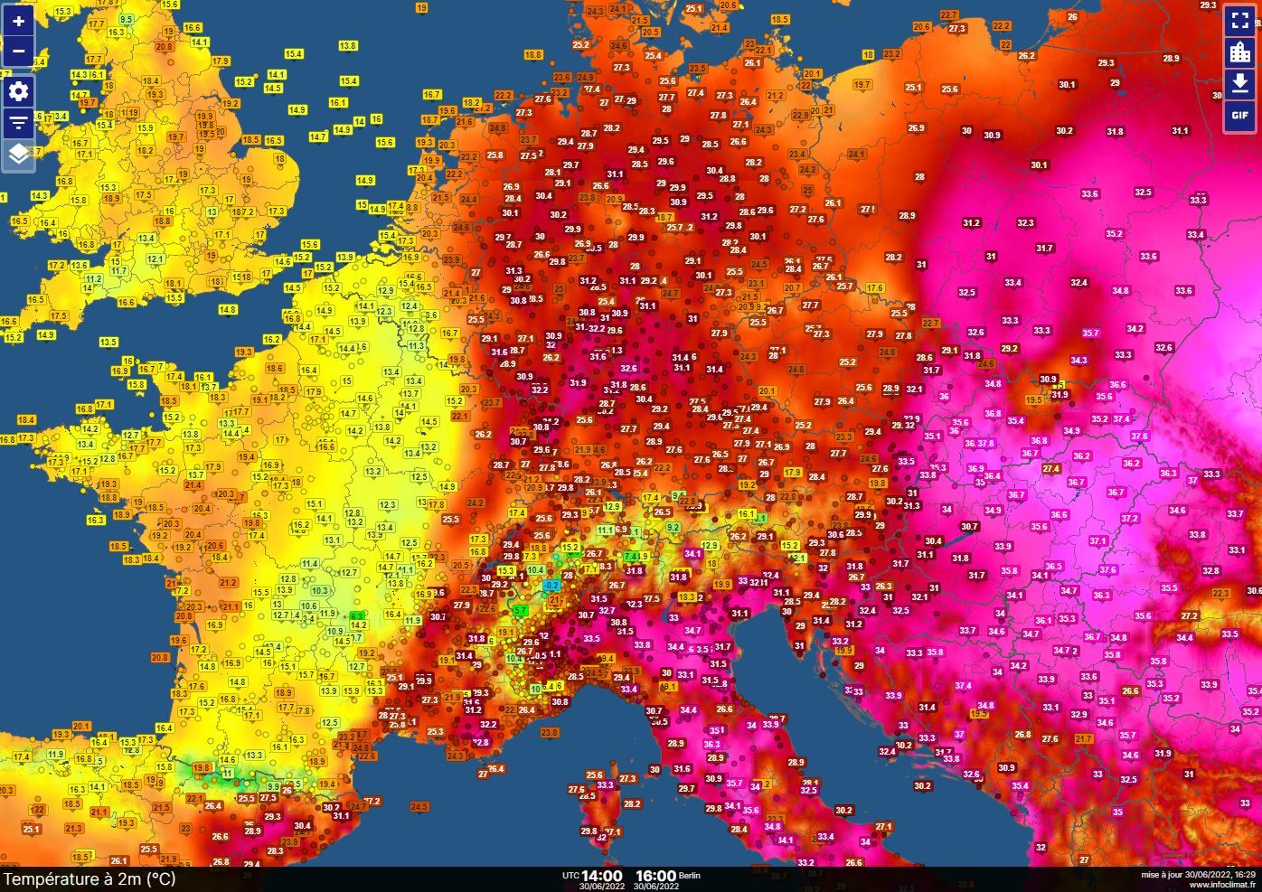
Umeå: 27C
Kronoby: 31.4C
Verdict: Umeå cucked!
|
|
|
|
Post by Met.Data on Jun 30, 2022 9:07:25 GMT -5
Every few hours I'm receiving notifications on my phone, saying, "Met Office releases weather warnings for....". But the worst that's happened is a bit of cloud. In fact the weather's been almost perfect for all sorts of outdoor activity. I may just report these as spam.
|
|
|
|
Post by Met.Data on Jun 30, 2022 11:31:58 GMT -5
I am in the park right now... there's a super dark cloud right Infront of me .. and it's drizzling. Classic blunderstorm. Will upload a pic later, can't believe a black cloud is just drizzling lol. Edit: Here's the pic. Blunderstorm! OK so in fact there were a couple of rumbles of thunder but it looked a lot worse than it was!  |
|
|
|
Post by Doña Jimena on Jun 30, 2022 14:27:36 GMT -5
Cloudy but dry. Not tropical anymore. Low 19.8C and high 27.3C in Riga.
|
|
|
|
Post by Ariete on Jun 30, 2022 14:34:14 GMT -5
5th consecutive 30C day for Turku with a high of 30.3C. It was a bit less humid today, the highest DP being 18.0C.
|
|
|
|
Post by greysrigging on Jun 30, 2022 15:37:16 GMT -5
5th consecutive below 30c day for Darwin. Although heavily overcast, DP's in the mid teens.
|
|
|
|
Post by aabc123 on Jun 30, 2022 16:14:08 GMT -5
30/06
28.1c/16.4c in Võru.
Despite the warm end of the month, the month as a whole was clearly less warm than last year's very warm June, daily mean was 1.7c cooler this year.
|
|
|
|
Post by Beercules on Jun 30, 2022 16:17:27 GMT -5
5th consecutive 30C day for Turku with a high of 30.3C. It was a bit less humid today, the highest DP being 18.0C. Such an achievement is almost unheard of on the polar coast of southern Vic and SE SA, 25* closer to the equator. Rediculous. |
|
|
|
Post by rozenn on Jun 30, 2022 16:33:29 GMT -5
Choose your color.  |
|
|
|
Post by Ethereal on Jun 30, 2022 21:28:40 GMT -5
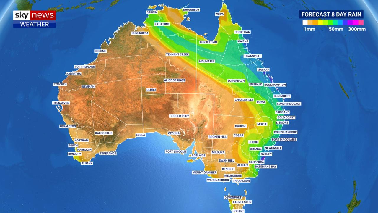
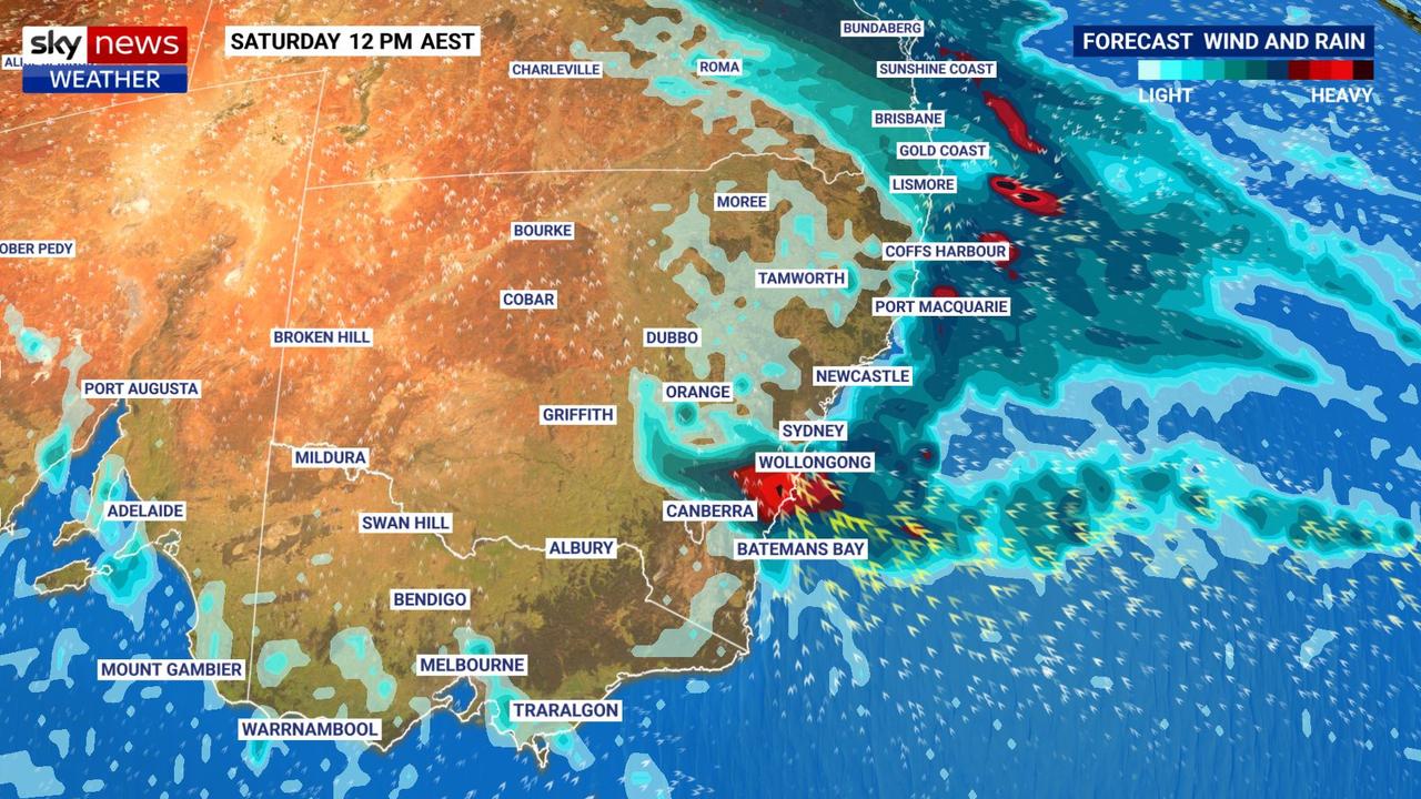
The next 8 days in the east will be get heavy "unseasonable rainfall" due to a deepening low pressure system combined with some tropical moisture streaming down from the north (great!). La Nina just doesn't want to leave us. A 2800 km stretch of the country - from Bateman's Bay in southern NSW, to Cooktown in Far North Queensland is on alert. The weather service says "accumulated rainfall totals of 100 to 200mm are likely in some parts of this region, with isolated falls above 300mm possible." The heavy rain will start on Friday before intensifying on Saturday. The low pressure system will also generate strong winds, potentially damaging winds" along the NSW coast and ranges from the weekend.   Aaaand of course the Sydney region will bear the brunt of it during rain bomb events. 🙄 SAM you need to come back! 😫 www.abc.net.au/news/2022-07-01/bom-forecasts-heavy-rain-for-nsw-flooding-possible/101196562P.S. I just realised that our winter rains don't come from cold fronts and are more tropical influenced. Which is a good thing I guess. 12C cold rain (from a cold front) is just doleful. Temperature here will be around 17C. |
|
|
|
Post by Babu on Jun 30, 2022 23:54:04 GMT -5
The dew point reached over 20'C at the airport yesterday, and we've been reaching dews between 17-20'C every day for almost a week now, very unusual for June. I've also recorded three nights in a row at my PWS with 18.8, 18.8 and 18.6'C lows (around 15-16'C at the airport) now. Fairly close to a "tropical" night but no cigarr, and now it seems the heatwave is dying down.
|
|
|
|
Post by Ethereal on Jul 1, 2022 3:17:48 GMT -5
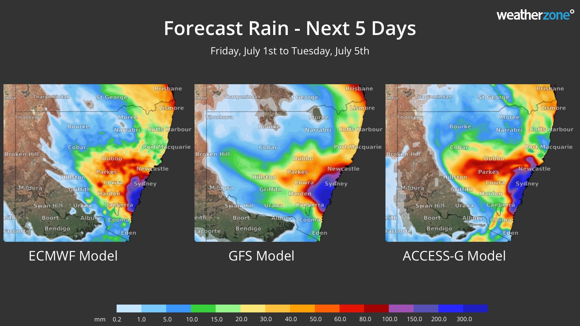
Just want to know why these rain bombs have the hots for Sydney, we're always in the bullseye of such rainstorms (prays these models are proved wrong!):  |
|
Deleted
Deleted Member
Posts: 0
|
Post by Deleted on Jul 1, 2022 4:24:53 GMT -5
|
|
|
|
Post by Ariete on Jul 1, 2022 14:17:22 GMT -5
28.3C high, 20.8C low. That was the end of the 30C+ streak.  |
|
|
|
Post by greysrigging on Jul 1, 2022 16:11:58 GMT -5
Extreme Chill In Outback Qld, Parts Of NT ( source: Weatherzone )  If you live in the southern half of Australia and you think it's a typically chilly winter day this Friday, spare a thought for residents of outback Queensland and even parts of the Northern Territory who are enduring an exceptionally cold day by their standards. Some of the readings in small towns and outback localities situated north of the Tropic of Capricorn are quite Canberra-like as we write this story in the middle of Friday afternoon. Well, perhaps not quite that cold – Canberra was just 7.1°C at 3:30 pm on a day of steady rain in the national capital – but pretty close. For example: The town of Camooweal (population approx. 200), northwest of Mt Isa near the NT border, was just 10.2°C at 3:30 pm, having reached a not-so-high 11.7°C earlier in the day. Its record low max for July is 11°C but its average July max is 25.9°C! Tennant Creek, in the NT's Barkly forecast district, was just 12.5°C at 3 pm local time (3:30 pm AEST), having reached 12.7°C a little earlier. Its record low max for July is 12.8°C but its average July max is 24.8°C! Whether today’s max is a record or not depends on the weather in the next few hours. These are just two examples. We could also pick some other well-known towns like Daly Waters (NT), Mt Isa (Qld) and several other spots whose names are familiar to most Australians – all of which are having exceptionally cold days, with unseasonable rain accompanying the chill in most cases. Why so cold? The current satellite image tells you most of what you need to know.  That broad cloudband stretching from Bali to the Tasman Sea has kept temperatures down, with thick cloud and cooling showers allowing almost no warming today. So anywhere that started the day with even a modest morning chill would have been hard-pressed to warm up. Again, Camooweal is a good example of that. Its minimum last night was 10.4°C at 7:52 am. It's not often a northern Queensland town would be warmer in the afternoon than the early morning, but then again, we don’t often see cloudbands covering that area during the Dry Season. It's also worth mentioning that the Southern Annular Mode (SAM) has recently turned positive, which indicates the likelihood of increased rainfall in the east. So while some of the rain might be unseasonable, it does have some support from SAM. Cool temps are expected to persist in most of the areas mentioned for the next 48 hours or so, before a gradual warming begins. |
|
|
|
Post by ral31 on Jul 1, 2022 20:46:14 GMT -5
Had a nice amount of rainfall today from tropical downpours associated with a disorganized system. I got 1.31", the most I've had in a few weeks. Never got above 82F. Last high we had below 90F was June 3rd.
|
|
|
|
Post by Ariete on Jul 2, 2022 2:44:24 GMT -5
Another warm night. Turku recorded a low of 21.2C. Highest seem to have been Rantasalmi in Eastern Finland with a 22.8C low.
|
|
|
|
Post by Babu on Jul 2, 2022 3:54:02 GMT -5
Umeå airport managed a 20.1'C low last night! Haven't checked the PWS yet but I wouldn't expect it to be much different since it was a cloudy night.
|
|
|
|
Post by Babu on Jul 2, 2022 4:10:25 GMT -5
28.3C high, 20.8C low. That was the end of the 30C+ streak.  I noticed yesterday how insanely consistent the heat has been in mid-western Finland.  Ok Kouvola isn't in the west but w/e |
|