|
|
Post by alex992 on Aug 5, 2022 23:51:28 GMT -5
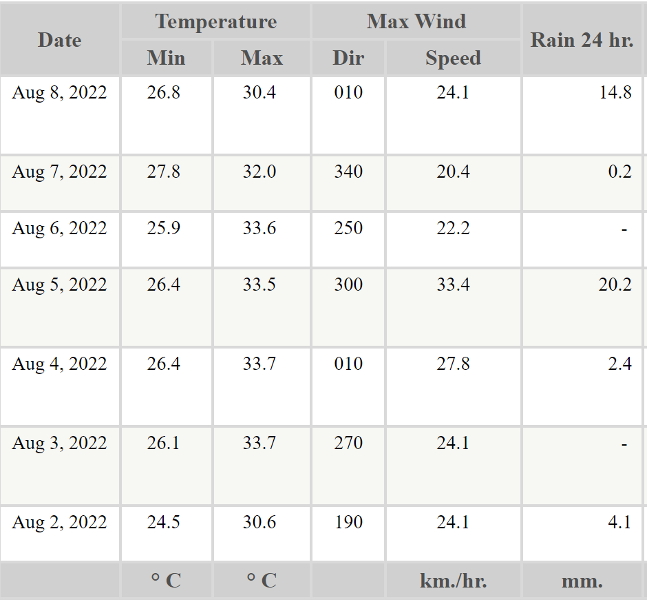
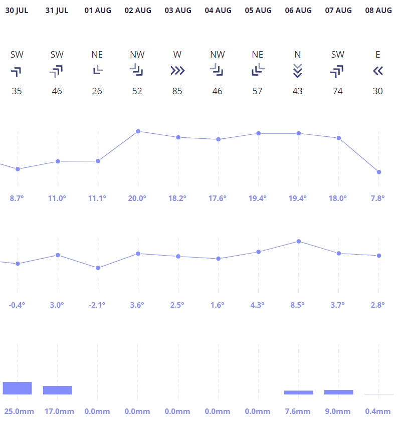
Just another day...   |
|
Deleted
Deleted Member
Posts: 0
|
Post by Deleted on Aug 6, 2022 5:28:08 GMT -5
GFS is now hinting at 37c next weekend (13th). If it happens, it could be the first time that 2 consecutive summer months have recorded 100f temps.
2020 came close with 100 in July in an otherwise cool month, and then 98 in August during the heatwave. No other year has been close.
|
|
|
|
Post by greysrigging on Aug 6, 2022 5:38:29 GMT -5
GFS is now hinting at 37c next weekend (13th). If it happens, it could be the first time that 2 consecutive summer months have recorded 100f temps. 2020 came close with 100 in July in an otherwise cool month, and then 98 in August during the heatwave. No other year has been close. You'll need 37.78c to crack the 100f mark  |
|
|
|
Post by Benfxmth on Aug 6, 2022 7:01:10 GMT -5
Just another day...   Subarctic maritime Raw-me/Rectum factor: 19478395093 |
|
|
|
Post by Steelernation on Aug 6, 2022 14:55:43 GMT -5
Fresno, CA had 0.05” (1 mm) of rain yesterday morning, the first measurable precipitation in August since 2007. It also makes this the wettest August since 1983!
Shows just how bone dry central California is in summer.
Meanwhile to the east, Minden, NV had 2.57” (65 mm) yesterday. That single day rainfall is more than any August monthly rainfall on record (por since 1901).
|
|
|
|
Post by greysrigging on Aug 6, 2022 16:17:28 GMT -5
The first +37.8c ( 100f ) max temp of the impending Southern Hemisphere spring/summer at Ngkurr in the Northern Territory   |
|
Deleted
Deleted Member
Posts: 0
|
Post by Deleted on Aug 6, 2022 19:41:27 GMT -5
|
|
Deleted
Deleted Member
Posts: 0
|
Post by Deleted on Aug 6, 2022 22:11:15 GMT -5
|
|
|
|
Post by ilmc90 on Aug 7, 2022 8:17:57 GMT -5
Very warm morning here but felt nice when the sun went behind the clouds and a breeze. Heat Advisory in effect not because of the milquetoast 91 F/33 C high but because of the high humidity and heat index near 100 F/38 C.   |
|
|
|
Post by ilmc90 on Aug 7, 2022 15:44:17 GMT -5
Heat Advisory extended through Tuesday:  |
|
|
|
Post by Steelernation on Aug 7, 2022 19:51:46 GMT -5
High was 93 (34 c) today with dews hovering around 70 (21 c). Very hot and muggy, but at least more interesting than 80s. Hottest temp since I arrived here and tied for the hottest temp of the year with a day in June.
|
|
Deleted
Deleted Member
Posts: 0
|
Post by Deleted on Aug 7, 2022 22:50:15 GMT -5
|
|
|
|
Post by greysrigging on Aug 8, 2022 0:32:13 GMT -5
Werstern Australia Snow Potential As Wintry Weather Arrives From Today ( source: Weatherzone )  One of this season’s coldest air masses to cross southwestern Australia could produce hail near Perth and deliver a dusting of snow in the Stirling Ranges during the next 48 hours. The satellite image below shows a long band of cloud arriving in southwestern Australia on Monday morning, revealing the location of a cold front. In the wake of this front, a large area of speckled clouds sitting off the west coast of Australia has formed in a pool of cold air that has drifted north from the Southern Ocean.  The front and proceeding cold air will both move towards the east on Monday and Tuesday, passing over a broad area of southwestern WA. Fortunately, this cold front is not as strong as the system that hit WA last week and caused the strongest wind gusts in years at some places. However, this week’s front will still pack a punch and cause a wintry mix of rain, hail, thunderstorms, blustery winds and possible snow. The cold front will arrive in Perth around lunch time on Monday, causing a burst of blustery winds, squally showers and a noticeable drop in temperature. The front will then continue to sweep towards the east, reaching Esperance by around 9pm. Cold air behind the front will allow showers to persist over the southwest of WA through Monday night and on Tuesday, with some areas likely to see small hail and thunderstorms. Models even suggest that temperatures will be low enough for a dusting of snow on the Stirling Range, most likely on Bluff Knoll. Maximum temperatures will struggle to reach the low teens over southwestern WA on Tuesday, making this one of the coldest days of the year.  Calmer weather and milder temperatures will return from Wednesday as a high pressure ridge starts to build over the region. |
|
|
|
Post by ilmc90 on Aug 8, 2022 17:07:19 GMT -5
Hot and humid today with a high/low of 94/71 F (34/22 C). Dewpoints have been in the 70s all day and peaked at 75 F/24 C. Heat index topped 101 F/38 C.
Very warm night tonight with a forecast low of 74 F/23 C.
|
|
|
|
Post by rpvan on Aug 8, 2022 18:50:25 GMT -5
Mid to long range forecast across North America:
|
|
|
|
Post by rpvan on Aug 8, 2022 18:51:53 GMT -5
Hurricane outlook:
|
|
|
|
Post by rpvan on Aug 8, 2022 18:56:51 GMT -5
Early winter thoughts for NA:
|
|
|
|
Post by greysrigging on Aug 9, 2022 1:30:27 GMT -5
A wintery day in and around Perth today....  |
|
|
|
Post by chesternz on Aug 9, 2022 6:33:05 GMT -5
It's been depressing here. On and off drizzle, no storms, and no sunny days for weeks:  ___ Unusual mild spell in Christchurch ends abruptly:  |
|
Deleted
Deleted Member
Posts: 0
|
Post by Deleted on Aug 9, 2022 11:16:31 GMT -5
Amber warning for heat from Thursday to Sunday in London. The 2nd heat warning in 3 weeks.
Today: 29-30c
Wednesday: 32c
Thursday: 35c
Friday: 36c
Saturday: 37c
Sunday: 35c
|
|