Deleted
Deleted Member
Posts: 0
|
Post by Deleted on Aug 28, 2022 19:44:27 GMT -5
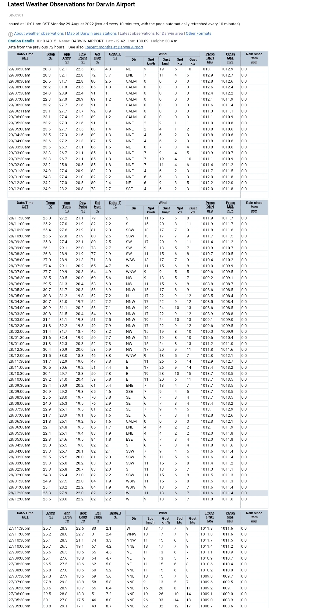
No half-hourly observations with a sub-18°C/64°F dew point at Darwin airport station for the past 40 hours... and no half-hourly readings with a sub-20°C/68°F dew point the past 16 hours. Buildup season is coming... the same way in Indonesian far southern islands www.bom.gov.au/products/IDD60901/IDD60901.94120.shtml |
|
|
|
Post by srfoskey on Sept 1, 2022 16:17:27 GMT -5
It's been around 75°F/24°C and rainy most of the day today. That's a good start to fall.
|
|
|
|
Post by Babu on Sept 2, 2022 8:21:10 GMT -5
Gladhammar reached 20'C every day between and including the 8th of June and 28th of August, a pretty impressive streak although 2018 managed a similar streak starting already in early May in some areas.
|
|
|
|
Post by rozenn on Sept 2, 2022 12:43:32 GMT -5
First sub-25°C day (<77°F) at Orly airport in 38 days. Summer's waning.  |
|
|
|
Post by Ariete on Sept 2, 2022 13:06:19 GMT -5
I'm gonna kill maself.
|
|
|
|
Post by rozenn on Sept 2, 2022 15:59:17 GMT -5
Plz don't. Quite the fizzer I got today. Not only was it cloudy and not warm, it was also nigh rainless. 24-hour rainfall with Ile-de-France circled in red:  |
|
|
|
Post by Steelernation on Sept 2, 2022 21:34:11 GMT -5
Had an awesome thunderstorm this evening, had about an hour of strobing cloud to cloud lightning, very frequent thunder, and gusty winds. Only 0.06” (1 mm) fell and it sprinkled for the first half hour so I could watch the show outside. Proof you don’t need much rain for a great storm.
The high was 94 (34 c), the hottest since early August. TWC has 96, 97, 96 to start next week which is very unusual for September. All 3 days could make a run at the record (99), definitely more interesting than constant low 90s.
|
|
|
|
Post by greysrigging on Sept 2, 2022 22:16:59 GMT -5
Australia yesterday/today. That drop of rain at Karijini is an outstanding fall for September. Aug-Nov normally rainless in the Pilbara.  |
|
|
|
Post by srfoskey on Sept 3, 2022 0:12:02 GMT -5
First sub-25°C day (<77°F) at Orly airport in 38 days. Summer's waning.  We had our first sub-25°C day of "fall" before you, on August 21. But our streak was 80 days long, going back to June 2. |
|
|
|
Post by Ariete on Sept 3, 2022 13:25:53 GMT -5
13.9C/2.6C diurnal today. 91-20 averages for 3 September are 19.0C/10.8C. Yahya Sinwar says "iTs NoT wElL bEloW aVeRaGe!!!" 6.6C below average. Off yerself. |
|
|
|
Post by Yahya Sinwar on Sept 3, 2022 13:32:44 GMT -5
13.9C/2.6C diurnal today. 91-20 averages for 3 September are 19.0C/10.8C. Yahya Sinwar says "iTs NoT wElL bEloW aVeRaGe!!!" 6.6C below average. Off yerself. Its pretty normal for september. |
|
|
|
Post by greysrigging on Sept 3, 2022 15:52:32 GMT -5
The first 3 days of Spring in Outback Australia.....outstanding anomalies below average temps ! ALICE SPRINGS  NEWMAN  BIRDSVILLE  |
|
|
|
Post by greysrigging on Sept 3, 2022 16:10:28 GMT -5
Unseasonable rain floods part of Australia's west and east ( source: Weatherzone )  Australia's interior and north are typically dry at this time of year but some of WA, Queensland and New South Wales have just been flooded by unseasonably heavy rain. There have been two distinct areas of significant rain, one in the west and another in the east, separated by thousands of kilometres of dry.  Slow-moving low-pressure troughs fuelled by tropical moisture have been the cause of these two rain areas. Recent rain across Queensland and northern NSW has been the heaviest in 2-4 months in many areas, 10 months at Birdsville (it's 24mm was enough for the first day of races to be cancelled www.weatherzone.com.au/news/birdsville-races-given-the-hook-due-to-rain/784983) and 9 months at Roma (51mm in 24 hours). It’s unusually wet for this time of year, the heaviest September rain in 56 years at Injune (45mm in 24 hours), 25 years at Warwick (42mm in 48 hours), 24 years at Dalby (37mm in 24 hours) and Toowoomba (23mm in 24 hours), 16 years at Lismore (45mm in 48 hours), 14 years at Surat (34mm in 24 hours) and Nambour (40mm in 24 hours) and 12 years at Tewantin (50mm in 48 hours), Logan (22mm in 48 hours) and Gympie (37mm) and 11 years at Taree (35mm). In WA, dust turned to mud in the Gascoyne and Pilbara with help from Indian Ocean moisture feeding a low. The past 24 hours (to 9am Saturday) have brought the heaviest rain in 3.5 years at Coodardy (35mm), 2.5 years at Bryah (35mm), Beebyn (32mm), 1.5 years at Barimunya (54mm), Winderie (42mm), Karijini (60mm) and Newman (33mm) and 15 months at Meekatharra (32mm). How unseasonable was it? Very. It was the heaviest September rain in more than 110 years at Murgoo (37mm), 98 years at Beebyn, more than 90 years at Bulloo Downs (31mm) and Doolgunna (28mm), more than 80 years at Carey Downs (34mm), more than 70 years at Meekatharra (32mm) and 52 years at Onslow (14mm). Both of these rain systems are now dying, causing rain to clear from most areas. However, the NSW north coast can expect some heavy downpours between now and Sunday morning as a low-pressure system intensifies offshore. This low will also generate damaging winds and surf.  Be sure to check the latest warnings as this weather event unfolds. Thankfully, flooding in both the west and east of the country has largely only been minor but it does add to soil saturation, making the next big rain event more problematic. |
|
|
|
Post by Morningrise on Sept 4, 2022 6:59:53 GMT -5
We have the potential to set a new monthly heat record today! The record highs for September at our two official weather stations are 35.3C and 35.6C, and today's forecast high is 36C. Yesterday we hit 35.1C, so we got close but not quite there. What a start to fall!
|
|
|
|
Post by alex992 on Sept 4, 2022 11:23:18 GMT -5
46 F (7.8 C) low at the airport this morning, breaks the streak of 86 consecutive days with lows of 50 F or higher, which ties the second longest streak on record.
About fucken time!
|
|
|
|
Post by srfoskey on Sept 4, 2022 12:34:32 GMT -5
Yesterday I was at a football game, and it got up to 94°F (34.5°C). I was sitting in the sun, so the heat was not fun. Hot day in the forecast for the Central Valley of California today.  |
|
|
|
Post by rozenn on Sept 4, 2022 16:00:22 GMT -5
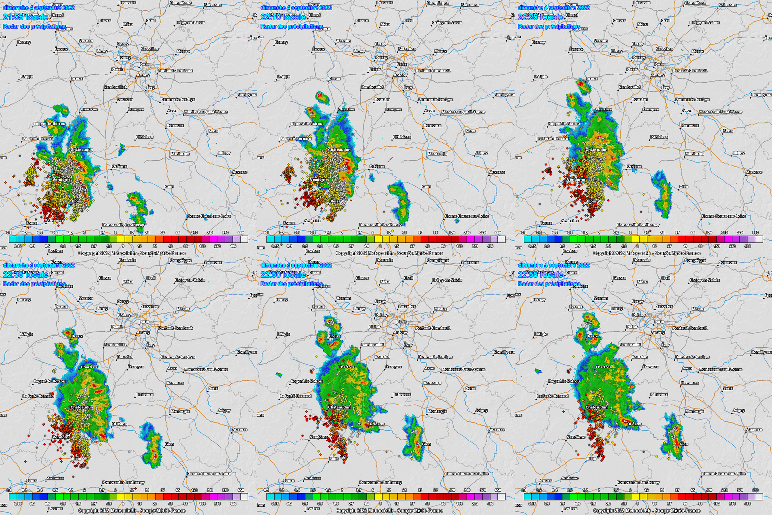
A line of storms is approaching from the SW, anvils were visible at sunset. Please note the waning CG lightning activity, meaning that it's dying right in the fucking ass. How typical.  |
|
|
|
Post by Morningrise on Sept 4, 2022 18:23:23 GMT -5
We have the potential to set a new monthly heat record today! The record highs for September at our two official weather stations are 35.3C and 35.6C, and today's forecast high is 36C. Yesterday we hit 35.1C, so we got close but not quite there. What a start to fall! And we did it! 35.5C at the airport weather station as of 5:00pm, beating out the previous record of 35.3C! I went out for a walk to experience it, but unfortunately it's very smokey outside right now. The other weather station in town is run by the Saskatchewan Research Council, but they only publish their data in the monthly summaries, so we'll have to wait until early October to find out if that one topped its record of 35.6C. |
|
|
|
Post by MET on Sept 4, 2022 20:53:00 GMT -5
A screenshot of the lightning map as there was a thunderstorm at 2AM approx, this is it 30 mins after passing Sheffield though as I was outside with my umbrella watching it when it happened. Edit, added the radar at 2:15AM as it started.   |
|
|
|
Post by rozenn on Sept 4, 2022 21:26:17 GMT -5
A line of storms is approaching from the SW, anvils were visible at sunset. Please note the waning CG lightning activity, meaning that it's dying right in the fucking ass. How typical. Actually that storm line died as expected, but convection build just after and a small storm just passed over my position. Unexpected. |
|