|
|
Post by rozenn on Sept 5, 2022 1:43:19 GMT -5
Round of storms coming for the western suburbs, they've been favored lately.  |
|
|
|
Post by dunnowhattoputhere on Sept 5, 2022 6:41:07 GMT -5
We had our first thunderstorm of the year last night. Pretty shocking that it’s taken until September to get one.
Also been a rather warm & humid start to September.
|
|
|
|
Post by Steelernation on Sept 5, 2022 11:50:57 GMT -5
We had our first thunderstorm of the year last night. Pretty shocking that it’s taken until September to get one. That’s shockingly bad, I know the UK doesn’t get many storms but not even a single one until now…horrific. |
|
|
|
Post by dunnowhattoputhere on Sept 5, 2022 11:59:22 GMT -5
We had our first thunderstorm of the year last night. Pretty shocking that it’s taken until September to get one. That’s shockingly bad, I know the UK doesn’t get many storms but not even a single one until now…horrific. We had our first storm last year in May by comparison I mean, we had literal 40C temps with an approaching cold front in July and that still wasn’t enough to get some storms. |
|
|
|
Post by ilmc90 on Sept 5, 2022 14:00:32 GMT -5
Flood Watch in effect this afternoon through midday tomorrow. Looks like there are flood watches from Alabama and Georgia up all the way through Maine. Could be a problem in some of the hard hit areas of Kentucky. 48 hour forecast for here:  |
|
|
|
Post by Ariete on Sept 5, 2022 14:10:13 GMT -5
Averages for the first 5 days of September: 13.9C/4.1C = 9.0C mean. Normal is 18.7C/10.3C = 14.5C.
This is actually the coldest start to September since 1959 at least (don't have older stats available).
So, Yahya Sinwar , pretty extraordinary. If you disagree, you have a shoe for a brain.
Averages for the first 5 days of October are: 12.1C/5.5C = 8.8C mean. So the lows have been cooler than even in early October.
|
|
|
|
Post by Steelernation on Sept 5, 2022 20:37:24 GMT -5
Didn’t get to the forecast today but still reached 96 (36 c). Next few days are supposed to be even hotter, with a good shot at tying or breaking the September record before a brief cool front brings some relief Friday.
Today was the 5th of 6 Septembers to hit 96 after just 2 of the first 123 got that hot. Record heat in September has become the norm, and no longer feels unusual at all.
|
|
|
|
Post by srfoskey on Sept 5, 2022 20:55:51 GMT -5
Even hotter in the Central Valley of California today, many monthly record highs set.
|
|
|
|
Post by Doña Jimena on Sept 6, 2022 1:55:19 GMT -5
Averages for the first 5 days of September: 13.9C/4.1C = 9.0C mean. Normal is 18.7C/10.3C = 14.5C.
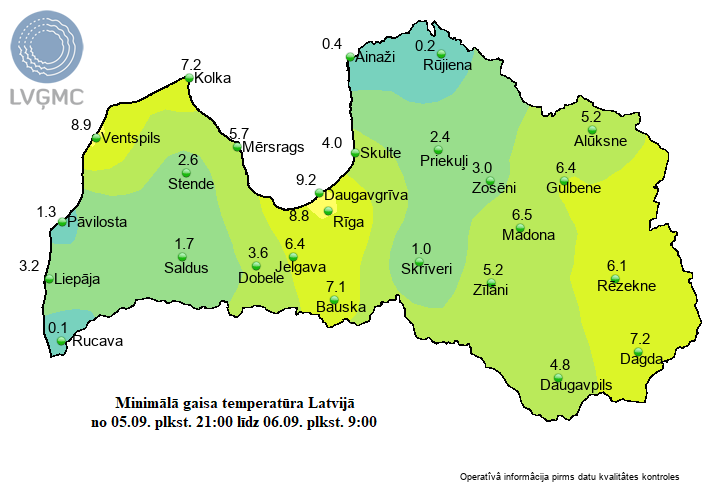
Mean of the first 5 days of September 2022 in Riga is 11.5C. Numerous cold records broken. Lows this morning  |
|
|
|
Post by Steelernation on Sept 6, 2022 21:17:28 GMT -5
High was 97.7 (36.5 c) today at the AgMesonet station (official data won’t come in for a few hours). Not quite the record but still very hot for September, hotter than anything in August for the 4th straight year.
From 1893-2016, it never got past 97 in September. Since then, it’s hit 98-99 in 2017, 2019, 2020, 2021, and 2022. That’s 4 years in a row doing something that had never been done for 123 years.
At this point I’m shocked it hasn’t hit 100 yet in September, maybe the next 2 days but I’m thinking 97-98 is more likely.
|
|
|
|
Post by greysrigging on Sept 7, 2022 2:54:06 GMT -5
|
|
|
|
Post by greysrigging on Sept 7, 2022 3:04:26 GMT -5
Record-Breaking Heat Gripping Western U.S. ( source: Weatherzone )  Parts of California have just endured their hottest day on record amid an extreme heatwave that is straining power grids across the Western U.S. A large and slow-moving upper-level ridge has allowed an extremely hot air mass to develop over the Western U.S. over the last few days. This ‘heat dome’ has already broken numerous records in several states, with more records tumbling in the last few hours.  The official weather station at Downtown Sacramento reached 116ºF (46.7ºC) on Tuesday afternoon. According to the National Weather Service, this beat the site’s previous all-time record of 114ºF from July 17, 1925. All-Time high temp records set or tied today. Downtown Sacramento reached 116 degrees today. This broke the previous all-time record high temperature of 114 set on July 17, 1925. Stockton reached 115 today which tied the previous all-time record set on July 23, 2006. #cawx — NWS Sacramento (@nwssacramento) September 7, 2022 Temperatures soared even higher in California’s Death Valley on Tuesday afternoon, where a unique combination of topography, altitude and the shape of the surrounding valley produce temperatures rarely seen anywhere else in the world. Death Valley’s Furnace Creek weather station hit 125.2ºF (51.8ºC) shortly before 5pm local time on Tuesday. This was only 0.4ºC below the maximum temperature world record for September, which is 126ºF (52.2ºC) from Mecca (USA) in 1950. Earlier in this heatwave, Furnace Creek also registered a minimum temperature of 101.8ºF (38.8ºC) on September 3. According to climate and weather historian Maximiliano Herrera, this is the equal highest minimum temperature ever recorded worldwide. Ahead of Tuesday's dangerous heat, California’s Independent System Operator (ISO) warned consumers to be prepared for possible power outages as soaring temperatures cranked up demand and put the network under strain. Then, as temperature records started to tumble, the ISO were forced to issue a level 3 Energy Emergency Alert (EEA), meaning controlled power outages are imminent or in process. According to the ISO, Tuesday night’s “electricity demand is currently forecast at more than 52,000 megawatts (MW), a new historic all-time high for the grid.” This heatwave has also caused numerous fires in western parts of the U.S. and Canada, with large smoke plumes visible from space on Tuesday afternoon.  Looking ahead, temperatures will start to drop later in the week as the heat dome breaks down over the region. |
|
|
|
Post by greysrigging on Sept 7, 2022 3:28:03 GMT -5
|
|
|
|
Post by sari on Sept 7, 2022 18:51:01 GMT -5
With all the focus on California, some have missed the insanity happening in Utah.
Record high for the month of September in Salt Lake City on 31 August 2022: 100F
September daily highs:
1st: 102F (record)
2nd: 100F
3rd: 103F (record)
4th: 102F
5th: 104F (record)
6th: 105F (record)
7th: 107F (record)
The 107 ties the all-time record high (for any month).
|
|
|
|
Post by MET on Sept 7, 2022 18:54:03 GMT -5
An interesting tool I use on Netweather showing the lightning for 7th September 2022.  |
|
|
|
Post by Steelernation on Sept 7, 2022 21:24:29 GMT -5
Big forecast bust, only got to 94 (34 c), forecast was 98.
One last shot at the record tomorrow although the forecast has been downgraded to 97 and none of the past few days have reached the forecast high.
Then we finally get a cool down and some variability! Forecast highs are only 66 and 62 Friday and Saturday which will feel amazing. Unfortunately it’ll go right back up but it’ll still be the first cool weather since early June.
|
|
|
|
Post by rozenn on Sept 8, 2022 0:03:12 GMT -5
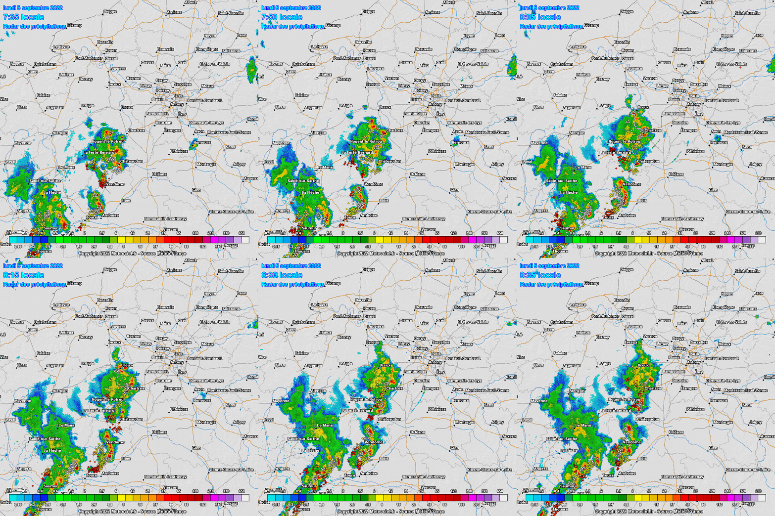
Strong storms in Paris region on Monday apparently. Always getting the cool stuff while I'm away:   |
|
|
|
Post by greysrigging on Sept 8, 2022 15:52:19 GMT -5
Lots of activity to Australia's north  |
|
|
|
Post by Steelernation on Sept 8, 2022 21:16:01 GMT -5
Horrible forecast bust today, got to 96 (36 c) at only 12:30 PM, several f warmer than the same time the last few days and well on the way to breaking the record. But then fucking clouds rollled in and dropped the temp to the low 90s.
Very underwhelming heatwave overall, at one point 4 straight days were forecast to hit 97+ and it seemed likely to at least tie the September record. Instead, we got 95, 97, 94, 96 and nothing close to the record. Hot and shitty but not enough to be exciting. It’s my anti interesting weather shield in full force…
Meanwhile, Glasgow, Montana up near the Canadian border hit 106 (41 c) yesterday. That’s insane for so far north in September.
|
|
|
|
Post by aabc123 on Sept 9, 2022 6:16:10 GMT -5
Hmm, -1.1c was recorded at my nearest station this morning, which should be a repeat of the absolute cold record for the first half of September (comes from the year of 1891). The daily mean has been about -5c below the average so far.
September extremes in my region are 30.3c/-6.6c, the first from the beginning of the month and the last one from the end of the month.
|
|