|
|
Post by ilmc90 on Nov 4, 2022 18:48:17 GMT -5
Impressive diurnal range here today with a high/low of 71/35 F (22/2 C). Warm start to November and this weekend is expected to be in the 70s. Almost a repeat performance today with a high/low of 71/36 F. Forecast low of 58 F/14 C (seems kind of high but we'll see) tonight and 60 F/16 C tomorrow. Highs of 73 F/23 C tomorrow through Monday before a cooldown on Tuesday. |
|
|
|
Post by ilmc90 on Nov 5, 2022 7:10:54 GMT -5
Low ended up being 54 F/12 C this morning, still way above average and closer to what the high should be for this time of year.
|
|
|
|
Post by rozenn on Nov 5, 2022 7:57:02 GMT -5
Chilliest night in a while, with lows ranging from 6.0°C in Montsouris to 0.2°C in Fontainebleau.
Orly has also beaten its yearly sunshine record at 2118 hours, with almost 2 months to come!
|
|
|
|
Post by Morningrise on Nov 5, 2022 8:47:46 GMT -5
We have our first winter storm warning in effect right now, potentially 10 to 20 cm of snow by tomorrow morning with strong winds and low visibility. So far we just had a few cm of snow overnight and the wind is calm. I went out to run an errand this morning, and I just love the peaceful atmosphere of light snow on the ground with calm air and the deep quiet that it brings, especially in the early morning with few people out. With a high of -2.7C, yesterday was our first ice day since April 15th. And judging by the forecast, there's plenty more of that coming right up. When is your average first ice day of fall? If you mean the average first day of the season where we experience a sub-freezing high, then I'm not sure about that one and don't think Environment Canada publishes that data. If you mean the first day of the season where the average high for the day is sub-freezing, that would be November 11th. If I had to guess, the average date for the former would probably be about a week or two before that, last week of October or first week of November sometime. |
|
|
|
Post by Ariete on Nov 5, 2022 13:11:31 GMT -5
Chilliest night in a while, with lows ranging from 6.0°C in Montsouris to 0.2°C in Fontainebleau. Orly has also beaten its yearly sunshine record at 2118 hours, with almost 2 months to come!
Ok so the total will be 2148.
|
|
|
|
Post by jetshnl on Nov 5, 2022 14:01:32 GMT -5
We have our first winter storm warning in effect right now, potentially 10 to 20 cm of snow by tomorrow morning with strong winds and low visibility. So far we just had a few cm of snow overnight and the wind is calm. I went out to run an errand this morning, and I just love the peaceful atmosphere of light snow on the ground with calm air and the deep quiet that it brings, especially in the early morning with few people out. When is your average first ice day of fall? If you mean the average first day of the season where we experience a sub-freezing high, then I'm not sure about that one and don't think Environment Canada publishes that data. If you mean the first day of the season where the average high for the day is sub-freezing, that would be November 11th. If I had to guess, the average date for the former would probably be about a week or two before that, last week of October or first week of November sometime. Saskatoon average first ice day 1991-2020 is 10-25. |
|
|
|
Post by rozenn on Nov 5, 2022 14:48:58 GMT -5
Chilliest night in a while, with lows ranging from 6.0°C in Montsouris to 0.2°C in Fontainebleau. Orly has also beaten its yearly sunshine record at 2118 hours, with almost 2 months to come!
Ok so the total will be 2148.
That's the most likely outcome indeed. Or maybe 2152 if we're lucky. |
|
|
|
Post by greysrigging on Nov 5, 2022 19:13:01 GMT -5
Tropical Cyclone Season Began In Australia ( source: weatherzone )  According to the Bureau of Meteorology, the Australian area of responsibility is between 90°E and 160°E and between 10°S and around 37°S (Figure 1). This includes coastal waters and land areas of Australia including Christmas Island, Cocos Island, Lord Howe Island, and Norfolk Island.  At this point, the Tropical Low was located about 10°S 90°E at 9am AWST Saturday (Figure 2). This low isn't likely to develop into a tropical cyclone as the conditions are not favorable. The low is also moving to the west which means it will not impact the Cocos Islands, but move further into the Indian Ocean.  In the coming days, meteorological models do not indicate any chance of developing tropical cyclones that could affect Australia. Anyway, the season is just getting started, so stay tuned for updates to warnings in your region. |
|
|
|
Post by cawfeefan on Nov 5, 2022 21:47:24 GMT -5
Chilliest night in a while, with lows ranging from 6.0°C in Montsouris to 0.2°C in Fontainebleau. Orly has also beaten its yearly sunshine record at 2118 hours, with almost 2 months to come! Melbourne is on 1726 hours YTD, so will be interesting to see if Paris can come out on top by the end of the year! |
|
|
|
Post by Steelernation on Nov 5, 2022 23:14:19 GMT -5
Rochester set its record warm low for November at 62 (17 c) today, then reached a high of 77 (25 c), warmer than anything in October.
Even more impressive is Shitchester is still 72 (22 c) at midnight. In November. Crazy.
|
|
|
|
Post by jgtheone on Nov 5, 2022 23:55:37 GMT -5
26.4C so far today, warmest temp since the 17th of April.
|
|
|
|
Post by greysrigging on Nov 6, 2022 2:51:29 GMT -5
Bit of activity over there in Java for Div.....  |
|
Deleted
Deleted Member
Posts: 0
|
Post by Deleted on Nov 6, 2022 2:57:20 GMT -5
greysrigging Looks stormy E/NE of Bandung. No storms here yet, but starting to cloud over
|
|
|
|
Post by ilmc90 on Nov 6, 2022 7:14:58 GMT -5
69 F/21 C and overcast here at 7AM. Temperature didn't drop below 68 F/20 C all night.  |
|
|
|
Post by 🖕🏿Mörön🖕🏿 on Nov 6, 2022 8:57:06 GMT -5
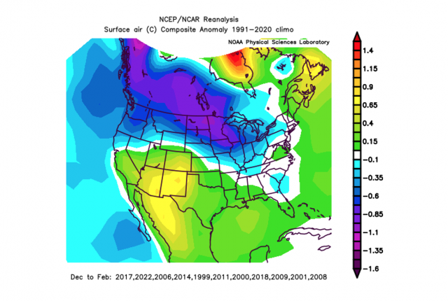
A composite of analogs for this winter:  Most of those years were very snowy here, and some colder than normal, despite what this map shows. |
|
|
|
Post by Ariete on Nov 6, 2022 10:24:59 GMT -5
Melbourne is on 1726 hours YTD, so will be interesting to see if Paris can come out on top by the end of the year!
I'd estimate a tad over 2000 hours here, so might still beat Melbourne!
|
|
|
|
Post by rozenn on Nov 6, 2022 17:19:27 GMT -5
It's this time of the year again!
Date - Hours - Temperature - Humidity - Octas
06-nov 17 h 9.9 °C 97% 7/8
06-nov 16 h 9.5 °C 96% 8/8
06-nov 15 h 9.4 °C 96% 8/8
06-nov 14 h 8.9 °C 95% 8/8
06-nov 13 h 9 °C 93% 8/8
06-nov 12 h 9 °C 90% 8/8
06-nov 11 h 9.1 °C 87% 8/8
06-nov 10 h 8.8 °C 88% 8/8
06-nov 9 h 8.9 °C 85% 7/8
06-nov 8 h 8.6 °C 87% 7/8
06-nov 7 h 8.8 °C 86% 7/8
06-nov 6 h 9.1 °C 85% 7/8
06-nov 5 h 9.6 °C 84% 8/8
06-nov 4 h 9.7 °C 84% 8/8
06-nov 3 h 10.1 °C 83% 8/8
06-nov 2 h 10 °C 84% 7/8
06-nov 1 h 9.5 °C 87% 7/8
06-nov 0 h 9.7 °C 87% 7/8
05-nov 23 h 9.7 °C 88% 7/8
05-nov 22 h 9.5 °C 89% 7/8
05-nov 21 h 9.5 °C 90% 7/8
05-nov 20 h 9.4 °C 90% 8/8
05-nov 19 h 9.6 °C 88% 8/8
05-nov 18 h 9.7 °C 87% 7/8
|
|
|
|
Post by jetshnl on Nov 6, 2022 18:38:26 GMT -5
A composite of analogs for this winter:  Most of those years were very snowy here, and some colder than normal, despite what this map shows. That is awesome, hope it turns out. |
|
|
|
Post by 🖕🏿Mörön🖕🏿 on Nov 6, 2022 18:39:15 GMT -5
A composite of analogs for this winter:  Most of those years were very snowy here, and some colder than normal, despite what this map shows. That is awesome, hope it turns out. You want cold?  |
|
Deleted
Deleted Member
Posts: 0
|
Post by Deleted on Nov 6, 2022 18:52:03 GMT -5
Bit of activity over there in Java for Div.....  South Jakarta ended up getting 20mm/0.8" of rain earlier this morning |
|