|
|
Post by greysrigging on Jul 31, 2023 2:55:49 GMT -5
Ahhh, July... the depths of winter in the Antipodes.... also 'winter' in the southern and central districts of the NT and 'peak dry season' in the Top End. 'Winter' in the Top End is a bit of a misnomer of course; the 30 year means 1991-2020 we average 19.3c/31.1c... the long term means 1941-2023 are 19.3c/30.7c. Despite the extreme cold max temps at the begining of July ( a vigorous north west cloud band ) that produced light unseason rain in the southern and central regions, July ended up being above average for both max and min temps throughout the Northern Territory. Alice Springs recorded only one sub zero minimum temp for the month (-0.1c ) in contrast to July 2022 that had 18 mins below zero ! The Alice had some near record breaking cold days early in the month, the first 3 days max temps of the month were 7.6c, 8.9c, and 11.3c ! In contrast, Darwin has just had two consecutive +34c days in July ( only 21 days in 82 years have exceeded 34c in July at Darwin Airport ) As usual, zero rain for the month in Darwin, but the month has been well above the norm for humidity and high DP's.... except for last week with neg dews and 5 consecutive days below 30c and a couple of sub 15c mins... but it was short lived and the heat has returned to finish the month of July.  Rainfall - 0.0mm ( long term mean 1.1mm- median 0.0mm ) Highest daily fall - 0.0mm Max temps - 31.6c av ( long term mean 30.7c ) Highest max - 34.7c on the 31st. Lowest max - 26.0c on the 25th Min temps - 20.4c av ( long term mean 19.3c ) Highest min - 23.2c on the 11th and 17th. Lowest min - 13.4c on the 25th    Rainfall - 13.0mm falling on 6 days ( long term mean 14.0mm, median 2.5mm ) Highest daily fall - 6.4mm on the 1st. Max temps - av 20.7c ( long term mean 19.9cc ) Highest max - 27.9c on the 28th. Lowest max - 7.6c on the 1st. Min temps - 5.0c av ( long term mean 4.0c ) Highest min - 15.5c on the 29th. Lowest min -0.1c on the 13th   |
|
|
|
Post by glacier on Jul 31, 2023 13:54:24 GMT -5
One of the most amazing things I've ever seen. Little Chicago, NWT, which is north of the Arctic circle, has averaged 28.9C/84.1F for the month of July with just today to go (average daily max). The only places in Canada to average hotter this month are a few of the hotter locations in the semi-arid southern interior of BC and Medicine Hat, Alberta!
|
|
|
|
Post by B87 on Jul 31, 2023 13:57:59 GMT -5
I'll post the weatherbox when all the data is out, but already the month will be cooler than average (av max is 1c below normal), around 140% of average precipitation and around 70% of average sun. It's the cloudiest July for 31 years.
|
|
|
|
Post by 🖕🏿Mörön🖕🏿 on Jul 31, 2023 16:22:44 GMT -5
One of the most amazing things I've ever seen. Little Chicago, NWT, which is north of the Arctic circle, has averaged 28.9C/84.1F for the month of July with just today to go (average daily max). The only places in Canada to average hotter this month are a few of the hotter locations in the semi-arid southern interior of BC and Medicine Hat, Alberta! A very warm month out this way as well in PEI/Nova Scotia/New Brunswick. Deviations aren't as high but still amongst the warmest on record (averaging around 79/64F here). Very wet as well with 6.10" of rain in Charlottetown and 5.10" or so in Summerside. July is usually the driest summer month here. |
|
|
|
Post by MET on Jul 31, 2023 18:23:42 GMT -5
July 2023 Summary - SE Sheffield
There's no question that if Drooly 2023 was a person it'd look like this:

Probably this too, after last year's joker heatwave, and because ALL the LRF's went for a warm, high pressure July.

What a surprise that in blighty we'd have nearly the wettest July on record after the "warmest June on record". Of course, it was only the "UK's" warmest June on record; "UK" records date only back to 1940's or so. Using Central England Temperature, there have been many warmer Junes before that. However, it appears that the Met Orifice enjoy picking and choosing which records they look at to make some point or other about some shit.
Back on point, what a hilarious and classically British deflation July was after June. Constant rain and no doubt one of the dullest on record too.
So what was off with this Drooly?
*2nd wettest on record
*Most rainy days (1mm or more) I've ever recorded in July
*longest period of consecutive below average max temps I've recorded
*lowest July maximum temperature ever recorded in my records
*Joint fewest 20°C ever recorded in July (along with 2020) at just 12 - the average is 22.
*2nd July I've ever recorded with avg. max below 20°C
*One of the dullest Julys I've ever recorded.
*ONE "warm sunny" day all month lmao
*ONE day reached 25°C all month haha - lowest ever
*I measured over 32 hours of rain this month
Why did this happen?
The same buckled/blocked Jetstream pattern that caused the heat domes over S/SE Europe kept on trapping low pressure directly over the UK. This was specially well timed with weekends, nearly all of which were washouts. One after another low pressure system swooped down over the UK and got stuck on top of us, blocked in permanently all month, making it a record wet month. Despite the globe having its warmest July recorded, the UK was the only place in the world to have these incredibly wet and cold conditions.
That said, it wasn't all gloom and doom, except the annoying high frequency of frontal rain in the second half. I appreciated the better indoor temps for sleeping in particular, and outdoor activities were aided by the cooler temps (when not raining). There was some decent convection in the first half of it but sadly just frontal shit in the second.
Anyway a classic Bri'ish crummer stinker, you can't expect to go more than 3 years without one lmao.


|
|
|
|
Post by Benfxmth on Jul 31, 2023 19:47:59 GMT -5
Synopsis: Above-average, with proper heat and humidity dominating, and a fucking truckload of lightning/T-storms (albeit not quite as much as July 2022)—especially the first half of the month. Typical summer SE ridging/offshore Bermuda high influence meant the lack of any real heatwaves but also kept gay cold fronts at bay as climatologically typical for July and there have been more highs in the 90s this July than the last due to less precip/cloud cover. There have been the inevitable fizzers here and there, but this is by far, by fucking far, the best month of 2023.    jsfiddle.net/t1u7mw60/ jsfiddle.net/t1u7mw60/Average 2 AM temperature: 76.6°F (24.8°C) Average 8 AM temperature: 79.1°F (26.2°C) Average 2 PM temperature: 87.2°F (30.7°C) Average 8 PM temperature: 81.3°F (27.4°C) Average 2 AM dewpoint: 74.4°F (23.6°C) Average 8 AM dewpoint: 75.8°F (24.3°C) Average 2 PM dewpoint: 75.5°F (24.2°C) Average 8 PM dewpoint: 74.4°F (23.6°C) Max. dewpoint: 82.2°F (27.9°C) on the 29th, 1:45 PM Min. dewpoint: 64.0°F (17.8°C) on the 1st, 12:20 PM Difference between true daily mean vs. max/min / 2: -0.8°F (-0.4°C) Largest diurnal range: 23.4°F (13.0°C) on the 4th Smallest diurnal range: 8.4°F (4.7°C) on the 14th Mean time of daily high and mean time of daily high after solar noon (not including highs which occurred at night): 2:42 PM (+1 hour and 28 minutes) No. precipitation days (>=0.01"): 15 No. precipitation days (>=0.04"): 13 No. precipitation days (>=0.1"): 8 No. precipitation days (>=0.4"): 5 No. precipitation days (>=1"): 3 Max. rainfall rate (1-min. avg.): 6.00"/hr (152.4 mm/hr) on the 8th, 5:55 PM Max. rainfall rate (10-min. avg.): 4.50"/hr (114.3 mm/hr) on the 8th, 5:36-5:46 PM Max. temperature of measurable precipitation: 87.4°F (30.8°C) on the 13th, 1:57 PM Min. temperature of measurable precipitation: 71.4°F (21.9°C) on the 4th, 11:05 PM Highest barometric pressure: 30.20 in (1022.7 mb) on the 28th Lowest barometric pressure: 29.76 in (1007.8 mb) on the 9th ________________________________________________________________________ Monthly departures at New Bern ASOS (relative to 1991-2020 normals): Average high: +1.7°F (+0.9°C; 83rd percentile 12th warmest on record) Mean: +2.0°F (+1.1°C; 87th percentile; 9th warmest on record) Average low: +2.3°F (+1.3°C; 94th percentile; 3rd warmest on record) Precipitation: -2.17" (-55.2 mm; 65% of normal; 21st percentile; 17th driest on record) ________________________________________________________________________ New records at New Bern ASOS: None ________________________________________________________________________  |
|
|
|
Post by tommyFL on Jul 31, 2023 23:34:11 GMT -5
July 2023 SummaryThe warmest month on record* (+2.2 °F/+1.2 °C) with near-normal precipitation (106% of average precipitation/58th percentile). *Not really, explained below     Highest daily max temp: 96.5 °F (35.8 °C) on the 24th Mean daily max temp: 92.8 °F (33.8 °C)Lowest daily max temp: 87.3 °F (30.7 °C) on the 27th Highest daily mean temp: 84.1 °F (28.9 °C) on the 11th Mean temp: 81.2 °F (27.3 °C)Lowest daily mean temp: 77.3 °F (25.2 °C) on the 17th Highest daily min temp: 77.5 °F (25.3 °C) on the 20th Mean daily min temp: 74.8 °F (23.8 °C)Lowest daily min temp: 71.4 °F (21.9 °C) on the 25th Highest diurnal range: 22.4 °F (12.4 °C) on the 24th Mean diurnal range: 18.0 °F (10.0 °C)Lowest diurnal range: 12.6 °F (7.0 °C) on the 20th Precipitation: 7.32" (185.9 mm)Number of days with precipitation ≥ 0.01" (0.3 mm): 17 daysHighest daily precipitaton: 1.80" (45.7 mm) on the 18th Highest precipitation rate (10-min mean): 3.78"/hr (96.0 mm/hr) on the 17th Duration of measurable precipitation: 21.8 hours (2.9% of the month)Highest temp with measurable precipitation: 87.7 °F (30.9 °C) on the 28th Mean temp of measurable precipitation: 76.7 °F (24.8 °C)Lowest temp with measurable precipitation: 71.4 °F (21.9 °C) on the 25th Highest relative humidity: 100% on 23 days Mean daily max relative humidity: 99.7%Highest daily mean relative humidity: 97.4% on the 17th Mean relative humidity: 87.9% Lowest daily mean relative humidity: 75.5% on the 24th Mean daily min relative humidity: 59.8%Lowest relative humidity: 44% on the 24th Highest dew point: 83.9 °F (28.8 °C) on the 17th Mean daily max dew point: 80.7 °F (27.1 °C)Highest daily mean dew point: 79.4 °F (26.3 °C) on the 20th Mean dew point: 76.9 °F (24.9 °C)Lowest daily mean dew point: 74.3 °F (23.5 °C) on the 24th Mean daily min dew point: 73.4 °F (23.0 °C)Lowest dew point: 68.4 °F (20.2 °C) on the 24th Highest barometric pressure: 30.20 inHg (1023 mbar) on the 24th Mean barometric pressure: 30.05 inHg (1018 mbar)Lowest barometric pressure: 29.93 inHg (1014 mbar) on the 22nd Highest difference in mean temp between consecutive days: 4.0 °F (2.2 °C) between the 7th and 8th, 8th and 9th, and 24th and 25th Mean daily variability (average difference in mean temp between consecutive days): 1.6 °F (0.9 °C)Observations are from 12 AM to 12 AM New July monthly records at Port Salerno 5W COOP station (1.3 mi/2.1 km SE) (since May 2002):Records denoted with an asterisk indicate a new record for all months. *Record highest average daily max temp: 92.8 °F (33.8 °C). Previous record 92.3 °F (33.5 °C) in July 2016 and August 2010.*Record highest average daily min temp: 76.0 °F (24.4 °C). Previous record 75.5 °F (24.2 °C) in July 2010.*Record highest average daily mean temp: 84.4 °F (29.1 °C). Previous record 83.5 °F (28.6 °C) in July 2016 and August 2010.Note: This is a new record by midpoint of max and min only. A warmer mean temp occurred as recently as August 2022. In other words, the mean temp this month was heavily biased towards the min temp due to frequent cloud cover and rain. Record highest number of days with max temp ≥ 95 °F (35 °C): 8 days. Previous record 6 days in 2015 and 2020.*Record highest number of days with min temp ≥ 75 °F (24 °C): 28 days. Previous record 23 days in August 2021.Observations are from 7 AM to 7 AM Full period of record averages for Port Salerno 5W COOP station for reference: Sunshine hours at Martin County Emergency Operations Center for 2023 and averages since 2020 (calculated from solar radiation):  Highest daily sunshine: 79% (10.8 hours) on the 2nd Lowest daily sunshine: 0% (0.0 hours) on the 17th
|
|
Deleted
Deleted Member
Posts: 0
|
Post by Deleted on Aug 1, 2023 3:12:10 GMT -5
|
|
|
|
Post by paddy234 on Aug 1, 2023 4:30:28 GMT -5
Perth, Western Australia July 2023 (Mid Winter)
Maximum monthly Temp: 21.6°C
Minimum monthly Temp: 1.3°C
Mean Max temp: 18.6°C (+0.1°C)
Mean Min temp: 9°C (+1.0°C)
Rainfall mm: 120.6.mm (-21mm)
Rainy days >1mm: 14
Sunshine hours: 174.7 hours (-14.3 hours)
Relative humidity: 64%
Overall a warmer and drier month than average which is a significant difference than last month which was much cooler. The biggest change i feel is how warm the low temperatures were this month. Sunshine hours were pretty much average which is something I notice that fluctuates the least here in Perth and rainy days were bang on average aswell
|
|
|
|
Post by jgtheone on Aug 1, 2023 4:51:04 GMT -5
Essendon July 2023 Summary:Average max: 14.9°C (+1.1°C) ← Tied record!! Average mean: 11.4°C (+1.4°C) Average min: 7.8°C (+1.7°C) ← New record!! Max high: 18.3°C (29th) Max low: 11.5°C (10th) Min high: 12.2°C (23rd) Min low: 2.8°C (26th) Precipitation: 19.0mm (50.7% of avg. precip) Precip days: 10 Precip days (>1mm): 5 Sun hours: 153.7 hrs (110.8% of avg sun hours) Highest wind gust: 72km/h from the N (20th) A record warm July for Essendon Ap. The maximums never dipping below 12C was probably the most striking feature about this month, as that has only happened once in 2009. Sunshine was above average and rainfall was well below average, where at one point it looked like it would also be the driest July on record. The month felt very sunny, probably amplified by the overly cloudy conditions we've had on average for the past 3 years. 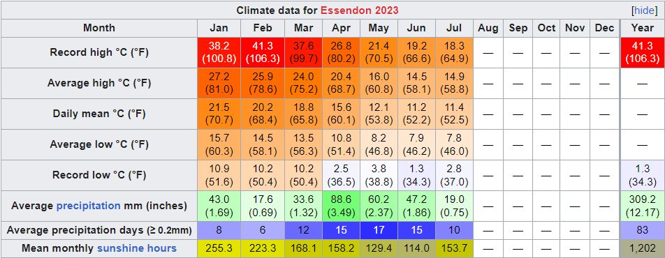 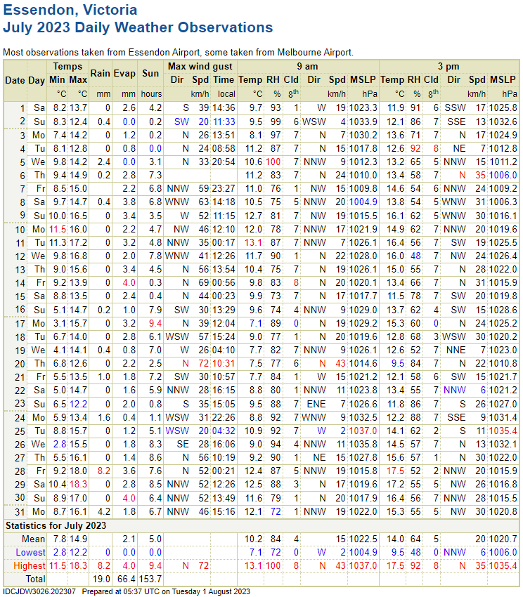
|
|
|
|
Post by cawfeefan on Aug 1, 2023 6:13:07 GMT -5
Scoresby July 2023 SummaryAverage max: 14.5c (+0.8c) - tied 2nd warmest Average mean: 10.9c (+1.0c) Average min: 7.3c (+1.1c) - tied 2nd warmest Max high: 17.3c (28th) Max low: 11.5c (14th) Min high: 11.4c (24th) Min low: 1.8c (27th) Precipitation: 35.2mm (54.7% of mean) Precipitation days: 17 Precipitation days >= 1mm: 11 Sunshine: 153.7 hours It was a very warm and dry July, with both maxima and minima tied for the second warmest on record. The month was only a degree above average, but it's actually significant since July is a very stable month here. Rainfall wise, it was looking to be the driest July on record, but some rain in the last few days prevented that from happening. Despite the dryness, more than half the days still received some precipitation in the form of light showers or drizzle, which I feel is a pretty Melbourne thing. It was our first month this year to be sunnier than average, and did indeed feel quite sunny. 
|
|
|
|
Post by Cadeau on Aug 1, 2023 7:03:00 GMT -5
Late July felt quite amazing! Hope rest of August will maintain the same weather pattern. Paris, Île-de-France, France July 2023 Average: High 25.9°C / Low 16.5°C / Mean 21.2°CHighest: 34.2°C [8th] Lowest: 12.1°C [5th] Lowest High: 20.2°C [25th] Highest Low: 21.7°C [9th] Precipitation: 106.7 mmPrecipitation Days: 8 Sunshine Hours: 232.0 hours Sunshine Percentage: 47.7% Early July: High 27.0°C / Low 16.6°C / Mean 21.8°C / Precipitation 17.1 mm / 90.4 sunshine hours Mid July: High 26.9°C / Low 16.7°C / Mean 21.8°C / Precipitation 3.3 mm / 91.4 sunshine hours Late July: High 23.9°C / Low 16.2°C / Mean 20.0°C / Precipitation 86.3 mm / 50.2 sunshine hours  - Seoul, South Korea July 2023 Average: High 30.2°C / Low 23.9°C / Mean 26.7°CHighest: 34.9°C [3rd,30th] Lowest: 21.6°C [9th,11th] Lowest High: 25.1°C [14th] Highest Low: 26.1°C [29th] Precipitation: 459.9 mmPrecipitation Days: 19 Snowfall: 0.0 cm Snowy Days: 0 Average Relative Humidity: 81% Average Dew Point: 22.9°C Average Wind Speed: 2.1 m/s Sunshine Hours: 146.1 hours Sunshine Percentage: 32.6% Early July: High 30.6°C / Low 23.0°C / Mean 26.5°C / Precipitation 136.1 mm / 56.1 sunshine hours Mid July: High 27.8°C / Low 23.4°C / Mean 25.4°C / Precipitation 239.0 mm / 25.0 sunshine hours Late July: High 32.0°C / Low 25.0°C / Mean 28.1°C / Precipitation 84.8 mm / 65.0 sunshine hours  - Tokyo, Japan July 2023 Average: High 33.9°C / Low 24.7°C / Mean 28.7°CHighest: 37.7°C [26th] Lowest: 20.7°C [2nd] Lowest High: 27.8°C [1st] Highest Low: 27.5°C [31st] Precipitation: 30.0 mmPrecipitation Days: 4 Snowfall: 0 cm Snowy Days: 0 Average Relative Humidity: 72% Average Wind Speed: 3.0 m/s Sunshine Hours: 250.4 hours Sunshine Percentage: 57% Early July: High 31.9°C / Low 23.1°C / Mean 27.1°C / Precipitation 30.0 mm / 56.9 sunshine hours Mid July: High 34.1°C / Low 25.8°C / Mean 29.6°C / Precipitation 0.0 mm / 70.4 sunshine hours Late July: High 35.4°C / Low 25.1°C / Mean 29.4°C / Precipitation 0.0 mm / 123.1 sunshine hours  *Note 1: The warmest July since record began in 1875. (1st of 149 years) *Note 1: The warmest July since record began in 1875. (1st of 149 years)| Rank | Mean Temp | Year | | 1st | 28.7°C | 2023 | | 2nd | 28.5°C
| 2001,2004 | | 4th | 28.3°C | 1994,2018 | | 6th | 28.0°C
| 2002,2010 | | 8th | 27.8°C
| 1978 | | 9th | 27.7°C | 2000 | | 10th | 27.6°C | 1955 |
|
|
|
|
Post by Morningrise on Aug 1, 2023 7:55:50 GMT -5
Well this was a first for me - July was cooler than June! And not by a slim margin either, a full degree and a half  I know this has happened in the past at least once or twice but it's exceptionally rare. June of course was several degrees above average which helped contribute to that. For the most part July was uncharacteristically mild with only a couple of very brief hot spells, and the second half of the month was a bit warmer than the first - when we were about halfway through the average temperature was barely warmer than May (which admittedly was also well above average this year). And just like May and June, it was very dry with the vast majority of the rainfall coming in a single rain event. Average high: 25.1C (normal: 25.3C) Average low: 10.3C (normal: 11.6C) Mean: temperature: 17.7C (normal: 18.5C) Warmest high: 33.2C (July 31st) Warmest low: 19.1C (July 25th) Coldest high: 18.9C (July 4th) Coldest low: 3.0C (July 5th) Precipitation total: 19.9mm (normal: 60.3mm) Precipitation days: 9 (normal: 11.2)  |
|
|
|
Post by firebird1988 on Aug 1, 2023 9:16:15 GMT -5
Phoenix, AZ July 2023 Summary
Highest Temp 48.3°C
Lowest Temp 27.2°C
Minimum High 42.2°C
Maximum Low 36.1°C
Avg High 45.9°C Dep +4.5°C
Avg Low 32.7°C Dep +3.8°C
Mean Temp 39.3°C Dep +4.15°C
Total Precip 0.00 mm
Departure -20.83 mm
Records=29
I. 10th Record Warm Minimum
(Tie 2010,2012,2020)
32.8°C Dep +3.9°C
II. 12th Record Warm Minimum
34.4°C Dep +5.5°C
III. 13th Record High
(Tie 1939,1989,2003,2005 &
2020)
45.6°C Dep +3.9°C
IV. 13th Record Warm Minimum
35°C Dep +6.1°C
V. 14th Record High
(Tie 2003)
46.7°C Dep +5°C
VI. 14th Record Warm Minimum
(Tie 2003 & 2013)
33.9°C Dep +5°C
VII. 15th Record High
47.8°C Dep +6.1°C
VIII. 16th Record Warm Minimum
(Tie 2010)
34.4°C Dep +5.5°C
IX. 17th Record High
(Tie 2005)
46.7°C Dep +5.6°C
X. 17th Record Warm Minimum
35°C Dep +6.1°C
XI. 18th Record High
47.8°C Dep +6.7°C
XII. 18th Record Warm Minimum
34.4°C Dep +5.5°C
XIII. 19th Record High
48.3°C Dep +7.2°C
XIV. 19th Record Warm Minimum*
36.1°C Dep +7.2°C
*=warmest minimum on record, and
warmest low in month of July
XV. 20th Record High
48.3°C Dep +7.2°C
XVI. 20th Record Warm Minimum
(Tie 1989 & 2020)
33.9°C Dep +5°C
XVII. 21st Record Warm Minimum
33.3°C Dep +3.9°C
XVIII. 22nd Record High
47.8°C Dep +6.7°C
XIX. 22nd Record Warm Minimum
35.6°C Dep +6.2°C
XX. 23rd Record Warm Minimum
34.4°C Dep +5°C
XXI. 24th Record High
(Tie 2014 & 2018)
46.7°C Dep +5.6°C
XXII. 24th Record Warm Minimum
34.4°C Dep +5°C
XXIII. 25th Record High
48.3°C Dep +7.2°C
XXIV. 25th Record Warm Minimum
(Tie 2018)
33.9°C Dep +5°C
XXV. 26th Record High
47.8°C Dep +6.7°C
XXVI. 28th Record Warm Minimum
33.9°C Dep +5°C
XXVII. 29th Record High
(Tie 1995 & 2020)
46.1°C Dep +5°C
XXVIII. 29th Record Warm Minimum
35°C Dep +6.1°C
XXIX. 30th Record Warm Minimum
33.9°C Dep +5°C
Five Warmest Days
I. 19th 42.2°C (48.3°C/36.1°C)
II. 22nd 41.7°C (47.8°C/35.6°C)
III(tie). 20th 41.1°C (48.3°C/33.9°C)
III(tie). 25th 41.1°C (48.3°C/33.9°C)
V. 18th 41.1°C (47.8°C/34.4°C)
Five Coolest Days
I. 31st 35.3°C (42.2°C/28.3°C)
II. 1st 36.4°C (45.6°C/27.2°C)
III. 7th 37.2°C (44.4°C/30°C)
IV. 8th 37.5°C (45°C/30°C)
V. 5th 37.8°C (43.9°C/31.7°C)
Was our hottest July on record (out of 128 total Julys) and our hottest month on record, beating out August 2020 by 2.0°C. Was also our 3rd rainless July on record, tying July 1993 and July 1995. And finally, was our 2nd month on record with no low temps below 80°F (the other was August 2011)
|
|
|
|
Post by kronan2 on Aug 1, 2023 9:27:25 GMT -5
Wettest July since 1939, and the 3rd wettest since records began.  Average high: -2.2C Mean: -1.4C Average low: -0.3C Precipitation: +109% Sunshine: -58h  |
|
|
|
Post by glacier on Aug 1, 2023 13:03:11 GMT -5
One of the most amazing things I've ever seen. Little Chicago, NWT, which is north of the Arctic circle, has averaged 28.9C/84.1F for the month of July with just today to go (average daily max). The only places in Canada to average hotter this month are a few of the hotter locations in the semi-arid southern interior of BC and Medicine Hat, Alberta! A very warm month out this way as well in PEI/Nova Scotia/New Brunswick. Deviations aren't as high but still amongst the warmest on record (averaging around 79/64F here). Very wet as well with 6.10" of rain in Charlottetown and 5.10" or so in Summerside. July is usually the driest summer month here. ![]() Even taking media temperature Little Chicago was warmer than any place in Nova Scotia or New Brunswick! Warmer than Kelowna BC (the airport).
Highest Median Temperatures in Canada for July 2023 (°C)
Osoyoos,BC = 24.497 Ashcroft, BC = 24.429 Lytton, BC = 24.103 Lillooet, BC = 23.906 Summerland, BC = 23.435 Kamloops, BC = 23.372 Penticton, BC = 23.306 Kelowna (UBCO), BC = 22.927 Creston, BC = 22.774 Port Weller, ON = 22.726 Montreal/Pierre Elliott Trudeau Intl, QC = 22.671 Montreal / Dorval, QC = 22.616 Mc Tavish, QC = 22.529 Toronto City, ON = 22.471 Burlington Piers, ON = 22.435 Vernon, BC = 22.339 Vineland, ON = 22.306 Point Pelee, ON = 22.3 Warfield, BC = 22.268 Toronto Pearson International Airport, ON = 22.21 Windsor, ON = 22.194 Saint Hubert, QC = 22.142 Little Chicago, NWT = 22.11Grenadier Island, ON = 22.106 Greenwood, NS = 22.087Lac Saint- Pierre, QC = 22.071 Kelowna (Airport), BC = 22.061 |
|
|
|
Post by Ariete on Aug 1, 2023 13:12:54 GMT -5
The Pee En Double Yoo heatwave didn't happen, but the En Double Yoo Tee heatwave did.
|
|
|
|
Post by B87 on Aug 2, 2023 3:54:45 GMT -5
 Juluary |
|
|
|
Post by caspase8 on Aug 2, 2023 5:52:11 GMT -5
Average July conditions (1991-2020) Average high: 14.1°C | Daily mean: 9.9°C | Average low: 5.6°C Average precipitation: 32.0mm | Average precipitation days (>0.2mm): 14.9 | Average relative humidity: 64%
An excessively mild, stable and dry month. The average high was 1.4°C above average, the warmest since 1975. The average low was similarly warm at 1.6°C above average, the highest since records began in 1943. Precipitation was the lowest since 2001, and would have been the lowest on record were it not for some decent falls in the last week of the month. Notably, there were no lows below 2°C and no highs below 12°C. This has not happened in July within the 80 years of records at the Laverton station. Overall a very autumn-like winter month.
|
|
|
|
Post by 🖕🏿Mörön🖕🏿 on Aug 2, 2023 7:23:58 GMT -5
Very nice month with no extreme heat, although it was one of the warmest Julys on record. Also much wetter than normal. It's very unusual for July to be both warm and wet here (usually cold/wet or hot/dry). Hopefully August is cooler and drier.  For June, Summerside is missing precip data for Day 16 through Day 22, where 15mm fell in Charlottetown. No snowfall or rain data there either. Thunderstorm days for me: 6 (all mid to end of month) |
|




 Lived:

 Residence:
 I know this has happened in the past at least once or twice but it's exceptionally rare. June of course was several degrees above average which helped contribute to that.


