|
|
Post by Shaheen Hassan on May 23, 2024 3:39:14 GMT -5
Big temp differences currently.
31.4°C with 74.1% humidity at the immediate coast, 41.8°C with 26.5% humidity in my area.
|
|
|
|
Post by Babu on May 23, 2024 3:56:43 GMT -5
Disgusting. May 2024 vs 1991-2024 in Umeå vs Trondheim airport   vs   Umeå is 0,4'C below average, Trondheim is 3,9'C above average. Ugh. I mean, this May has been overall pretty alright in Umeå with at least highs and sunshine above average, but it's considerably less nice when I know everywhere else in Sweden and especially Norway are having an amazing May. Temp anomaly map for Sweden:  Vindeln-Sunnansjönäs, the closest other station to Umeå, 45 km northwest and at 250 m altitude, normally averages 13.1'C highs in May (vs our 13.0'C). They're at 15.9'C so far this May vs our 13.8'C. Västmarkum, the same distance to the sea (but 150m higher altitude) as Umeå but an hour's drive south averages the same 13.0'C May highs as us but is sitting at 15.6'C. |
|
|
|
Post by Babu on May 23, 2024 4:26:07 GMT -5
Actually, the comparison with Norway gets even worse when viewed out of the context of the year as a whole. This is our year compared to average:   VS Trondheim airport:   A table of the deviations:
| Umeå airport | Trondheim airport | | January | -4.8 | -1.6 | | February | +0.9 | +0.6 | | Mars | +1.2 | +3.0 | | April | -1.7 | -0.2 | | May | -0.4 | +3.9 | | Total | -1.0 | +1.1 |
There's a 2,1'C difference in temp anomaly so far this year. Bruh. |
|
|
|
Post by Beercules on May 23, 2024 5:52:13 GMT -5
HA HA! UMEA SHITTEST CLIMATE ON THE PLANET TROLLOL LOL LOL
7C here @ 8.20pm, -1C forecast
|
|
|
|
Post by Ariete on May 23, 2024 5:52:18 GMT -5
Babu check out Bergen... running 5C above average... 
|
|
|
|
Post by Shaheen Hassan on May 23, 2024 6:28:53 GMT -5
A cold wave is going to affect Southern Peruvian Amazon starting from Saturday. Max Temps expected to drop to 21°C at latitudes as low as 10°S.
I think the Peruvian Amazon is the only tropical rainforest in the world prone to such cold waves so close to the equator. Is there any other deep tropical place that gets regular cold waves?
|
|
|
|
Post by MET on May 23, 2024 7:17:55 GMT -5
Well, this is one for B87 - a limpet-low stuck over the UK with better weather for everywhere else as we head into crummer. I don't care as long as it doesn't rain too much. I am sure it will, however.  |
|
|
|
Post by greysrigging on May 23, 2024 16:42:04 GMT -5
Record Run Of May Heat In Perth ( source: Weatherzone )  Perth has never seen a run of May days this warm since records started being kept in 1876. Since May 7, Perth's maximum has reached between 24.9°C and 29.4°C every day. The previous record run of May days with a top of 24°C or higher was in 2018, with 16 consecutive days. As of 9 am Thursday, Perth has just equalled the streak of 16 straight days above 24°C, and as mentioned, each of those days has reached at least 24.9°C. So the city is in record-setting territory for late autumn warmth. For perspective, Perth's average May maximum from 1993 to 2023 was 22.3°C at the city's official Perth Metro site. Prior to 1993, the average May maximum at the old Perth regional Office site from 1876 to 1992 was 20.9°C. The two sites are 4 km apart and at a similar elevation, so the average temperature rise is consistent with climate change. Meanwhile the current streak is not over yet.  Perth's warm weather looks set to continue with winter barely a week away, with Thursday's top tipped to reach 27°C, followed by highs of 26°C, 24°C and 25°C through to Sunday before things cool down slightly in the new week. OUR PERTH WEATHER FORECAST IS HERE  As ever, even the quickest glance at our synoptic chart reveals the reason for the persistent late May warmth.  Stubborn, slow-moving high pressure systems centred over the Great Australian Bight have been pushing warm air from the interior of Western Australia towards the southwest of the state (air circulates anti-clockwise around a high). Those same highs have been winning the atmospheric arm wrestle with the cold fronts, forcing most of them south of the mainland. Like most cold fronts to appear on charts in recent weeks, the one situated southwest of the continent in the chart above will also slide south and only graze the SW corner of the state. The front should pack enough of a punch to generate at least a few showers in coming days in Perth itself and across the Lower West, South West and South Coastal forecast districts, although temperatures will remain warm until an injection of slightly cooler air under southerly winds in the new week. Even chilly old Albany – the southernmost town in Western Australia – is expected to see maximums of 23°C, 25°C, 23°C and 24°C from today through to Sunday. These mild maximums are expected even with the likelihood of showers. Given that cloudy weather tends to reduce the amount of direct sunlight for warming, it shows just how warm the airmass over the southwest corner of WA is for this time of year. Albany's average maximum in May 2024 to date has been 22.7°C. That’s 3.2 degrees warmer than usual. |
|
|
|
Post by greysrigging on May 23, 2024 18:42:01 GMT -5
|
|
|
|
Post by greysrigging on May 24, 2024 14:59:31 GMT -5
AU capitals at 5.30am Eastern Standard Time  |
|
|
|
Post by rozenn on May 24, 2024 18:03:59 GMT -5
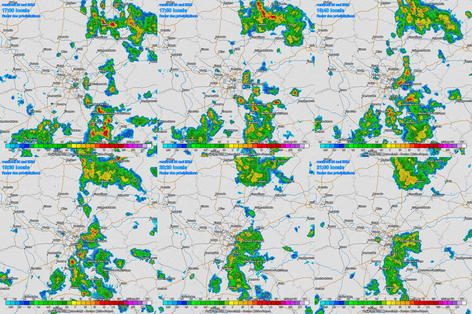
Fuck that. Stationary cells all over the eastern suburbs while we get fuck all here. 4-hour loop:  |
|
|
|
Post by Benfxmth on May 24, 2024 18:39:40 GMT -5
|
|
|
|
Post by chesternz on May 25, 2024 7:28:44 GMT -5
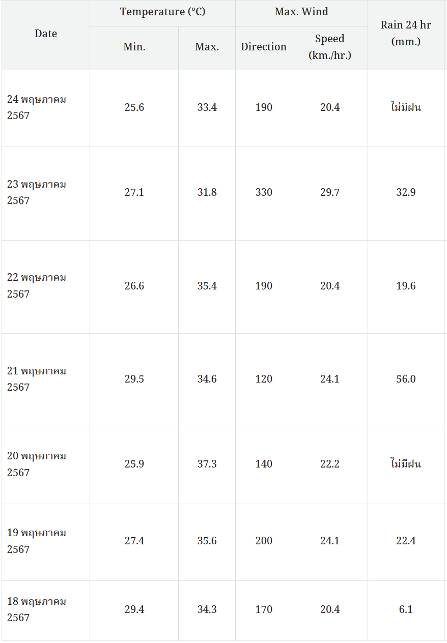
Transitioning into the monsoon season over the past week. Had some heavy falls and the hot sunny days are much less common now:  |
|
|
|
Post by srfoskey on May 25, 2024 11:01:19 GMT -5
|
|
|
|
Post by srfoskey on May 25, 2024 15:44:22 GMT -5
Tornado watch has been issued.
|
|
|
|
Post by srfoskey on May 26, 2024 12:03:14 GMT -5
Thankfully we didn't get anything too bad in my area, just an ordinary thunderstorm. Most of the severe weather stayed to the north and south. But given a Moderate Risk in February 2023 dropped a tornado a mile from my apartment, those days always make me worry.
Today should be hot with a forecast high of 93°F (34°C).
|
|
|
|
Post by aabc123 on May 26, 2024 15:30:29 GMT -5
Yeah, the station has had 1.9 mm of rain during the month of May, the average is 53 mm. The fire hazard is high  Lakes and rivers are mostly swimmable, the temperatures  Sea water, nearest places to my area tonight Pärnu 17.5c, Kabli-Häädemeeste area 18.2c, Narva area 17.6c. (But already 21.8c in Mõntu on Sõrve peninsula.) |
|
|
|
Post by Babu on May 27, 2024 1:29:43 GMT -5
A number of different stations in Norway around Trondheim recorded 30'C yesterday, warmest among them being Frosta with 31.1'C. I'm pretty sus about that station though because it's located on a slender peninsula and has warmer winters than the other stations in the region, but it also has the warmest summers including average highs even compared to the stations further away from the ocean.
|
|
|
|
Post by Benfxmth on May 27, 2024 15:18:42 GMT -5
I'm currently having 12-13°F higher dewpoints than tommyFL right now, following post storm clearing. New Bern AP reported a 76°F (24°C) dewpoint at 4 PM which is 2°F shy of the highest May dewpoint on record. Let it be shown for posterity.   |
|
|
|
Post by desiccatedi85 on May 27, 2024 15:44:50 GMT -5
Benfxmth yeah but it's 97ºF in Tommyville, much better weather than you're having, you should be jealous. You're becoming less of a heat wanker, it's pathetic. |
|