|
|
Post by greysrigging on May 31, 2024 2:43:02 GMT -5
The first 'dry season' month finished climatically ( still 5 hours to go by the calendar, but the data for the month is complete. ) May has been exceptionally warm and dry across the NT... in fact there will be quite a few monthly mean max temps records set including Darwin Airport which had a monthly mean max record of 33.7c ... breaking the previous record of 33.6c set in 2022. Darwin Airport recorded no rain for May, keeping with the normal dry trend of a dry season month. A feature of the month re Darwin has been higher than normal mins temps and dps and only one sub 20c min recorded for the month. +25c mins and +24c dps overnight are not the norm in the last week of May... Alice Springs had a reasonably average month of May... the max temps ended up being right on the long term average thanks to a pair of 16c max temps on the last 2 days of the month that also produced 40mm of rain thanks to a good old fashioned northwest cloudband streaming across the continent from the Indian Ocean. The Alice also recorded the first sub zero mins of the impending winter. As usual the Gove Peninsular continued to get a few showers and storms from QLD 'gulf lines' and the Gregory and VRD districts over west towards the WA border have seen an increase in cloud and cooler conditions with the northwest cloudband.  Rainfall - Nil rainfall ( long term mean 20.2mm, median 3.5mm ) Highest daily fall - Nil Max temps - 33.7c av ( long term mean 32.1c ) Highest max - 35.1c on the 10th. Lowest max - 30.5c on the 30th Min temps - 23.7c av ( long term mean 22.2c ) Highest min - 26.6c on the 10th. Lowest min - 19.1c on the 21st.    Rainfall - 42.0mm falling on 2 days ( long term mean 17.7mm) Highest daily fall - 28.0mm Max temps - 23.2c av ( long term mean 23.2c) Highest max 28.2c on the 29th. Lowest max 16.6c on the 26th Min temps - 6.6c av ( long term mean 8.1c ) Highest min 15.1c on the 30th. Lowest min -0.3c on the 20th.   |
|
|
|
Post by MET on May 31, 2024 19:03:51 GMT -5
May 2024 Weather Summary at Halfway South YorkshireData from Sheffield Weston Park Weather Station. May 2024 was the second mildest on record. The month was once again, cloudier than average, which kept minimum temperatures very mild in particular. Maximum temperatures were mild albeit unexceptional. The warmest May maximum temperature was recorded since May 2020. The rainfall was actually below the average for this weather station, although in other parts of the country, it was above average. The higher than average cloud gave a damper and rainier month despite this, with rain generally being drizzly and light, sometimes prolonged. It was a boring, mild and humid month. Spring 2024 on the whole was unusually cloudy, and one of the rainiest recorded in terms of rain days and rain frequency in particular. Despite also being possibly the mildest spring on record, it was not one most people who prefer sunnier weather will remember fondly.  
|
|
|
|
Post by tommyFL on Jun 1, 2024 0:03:40 GMT -5
May 2024 SummaryThe warmest May on record (+3.5 °F/+1.9 °C) with near-normal precipitation* (64% of average precipitation/43rd percentile)*includes 1.57" on April 30th    Highest daily max temp: 99.6 °F (37.6 °C) on the 18th Mean daily max temp: 91.6 °F (33.1 °C)Lowest daily max temp: 85.1 °F (29.5 °C) on the 2nd Highest daily mean temp: 84.2 °F (29.0 °C) on the 27th Mean temp: 79.7 °F (26.5 °C)Lowest daily mean temp: 73.8 °F (23.2 °C) on the 1st Highest daily min temp: 76.0 °F (24.4 °C) on the 16th Mean daily min temp: 71.0 °F (21.7 °C)Lowest daily min temp: 66.0 °F (18.9 °C) on the 1st Highest diurnal range: 29.0 °F (16.1 °C) on the 9th Mean diurnal range: 20.5 °F (11.4 °C)Lowest diurnal range: 15.3 °F (8.5 °C) on the 31st Precipitation: 1.97" (50.1 mm)Number of days with precipitation ≥ 0.01" (0.3 mm): 6 daysHighest daily precipitation: 0.76" (19.3 mm) on the 28th Highest instantaneous precipitation rate: 7.21"/hr (183.1 mm/hr) on the 28th Duration of measurable precipitation: 11.8 hours (1.6% of the month)Highest temp with measurable precipitation: 85.6 °F (29.8 °C) on the 28th Mean temp of measurable precipitation: 76.1 °F (24.5 °C)Lowest temp with measurable precipitation: 70.2 °F (21.2 °C) on the 19th Highest relative humidity: 100% on the 20th and 29th Mean daily max relative humidity: 97.0%Highest daily mean relative humidity: 84.6% on the 16th Mean relative humidity: 77.9% Lowest daily mean relative humidity: 69.2% on the 10th Mean daily min relative humidity: 50.9%Lowest relative humidity: 35% on the 27th Highest dew point: 80.1 °F (26.7 °C) on the 16th Mean daily max dew point: 75.1 °F (23.9 °C)Highest daily mean dew point: 76.4 °F (24.7 °C) on the 16th Mean dew point: 71.5 °F (21.9 °C)Lowest daily mean dew point: 67.1 °F (19.5 °C) on the 5th Mean daily min dew point: 67.8 °F (19.9 °C)Lowest dew point: 61.5 °F (16.4 °C) on the 30th Highest barometric pressure: 30.11 inHg (1020 mbar) on the 31st Mean barometric pressure: 29.93 inHg (1014 mbar)Lowest barometric pressure: 29.75 inHg (1008 mbar) on the 10th Largest 1-day mean temp rise: 4.3 °F (2.4 °C) between the 13th and 14th Largest 1-day mean temp drop: 3.9 °F (2.2 °C) between the 18th and 19th Mean daily variability (average difference in mean temp between consecutive days): 1.4 °F (0.8 °C)Observations are from 12 AM to 12 AM New May monthly records at Port Salerno 5W COOP station (1.3 mi/2.1 km SE) (since May 2002):Record highest mean daily max temp: 89.8 °F (32.1 °C). Previous record 88.3 °F (31.3 °C) in 2006.Record highest number of days with max temp ≥ 95 °F (35 °C): 5 days. Previous record 0 days.Record lowest number of days with max temp < 85 °F (29 °C): 3 days. Previous record 4 days in 2011.Record highest monthly mean temp: 80.5 °F (26.9 °C). Previous record 78.4 °F (25.8 °C) in 2010.Record highest mean daily min temp: 71.3 °F (21.8 °C). Previous record 70.3 °F (21.3 °C) in 2010.Record highest number of days with min temp ≥ 75 °F (24 °C): 7 days. Previous record 3 days in 2017.Observations are from 7 AM to 7 AM Full period of record averages for Port Salerno 5W COOP station for reference: Sunshine hours at Martin County Emergency Operations Center for 2024 and averages since 2020 (calculated from solar radiation):  Highest daily sunshine: 91% (12.3 hours) on the 23rd Lowest daily sunshine: 16% (2.1 hours) on the 15th  Allapattah Flats: 
|
|
|
|
Post by jgtheone on Jun 1, 2024 5:58:30 GMT -5
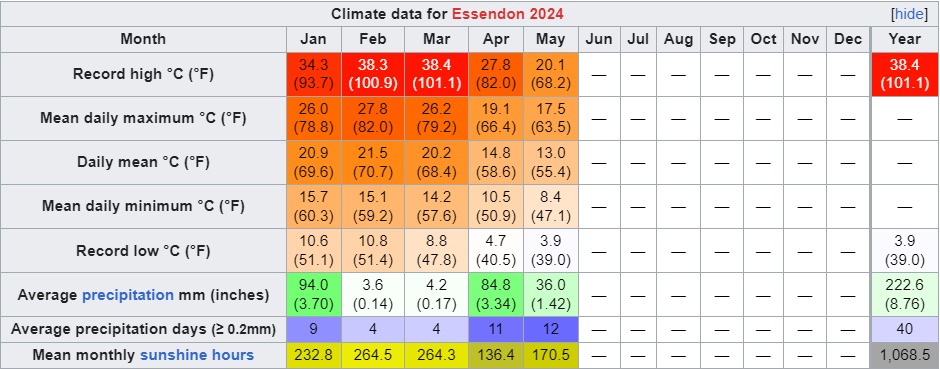
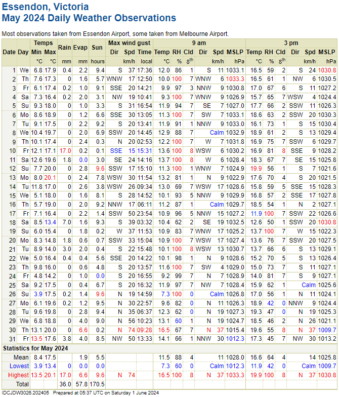
Essendon May 2024 Summary:Average max: 17.5°C (+0.4°C) Average mean: 13.0°C (+0.2°C) Average min: 8.4°C (-0.1°C) Max high: 20.1°C (13th) Max low: 13.5°C (31st) Min high: 13.4°C (18th) Min low: 3.9°C (26th) Precipitation: 36.0mm (90.5% of avg. precip) Precip days: 12 Precip days (>1mm): 6 Sun hours: 170.5 hrs (118.2% of avg sun hours) <- New record! Highest wind gust: 74km/h from the N (30th) This month was dominated by a high pressure system that simply did not move. It was stuck in the Great Australian Bight for almost the entire month, which led to incredibly stable, average and mostly sunny days. Not much in the way of interesting weather on the surface, but it was notably more humid than usual, with a lot of readings of 100% RH in the morning, and it was also much more still than usual, with a gust of wind barely exceeding 50km/h until the very end of the month when the high managed to finally budge. Temperatures and rainfall were otherwise average. Another funny thing is that after a record cloudy April, we had a record sunny May. Funny how that works sometimes.  
|
|
|
|
Post by Benfxmth on Jun 1, 2024 7:18:08 GMT -5
Another above average month! Very solid with warm temps prevailing for the most part, May 2024 ended up with very similar avg temps to May 2022 but less variability. The first and last 10 days were notably warmer than mid-month, though even the couple of boring ass cloudy polar outbreaks with heavily moderated temps had brought min temps well above the monthly mean min climo for May.    Average 2 AM temperature: 67.5°F (19.7°C) Average 8 AM temperature: 69.0°F (20.6°C) Average 2 PM temperature: 77.7°F (25.4°C) Average 8 PM temperature: 73.9°F (23.3°C) Average 2 AM dewpoint: 64.2°F (17.9°C) Average 8 AM dewpoint: 65.4°F (18.6°C) Average 2 PM dewpoint: 65.5°F (18.6°C) Average 8 PM dewpoint: 65.4°F (18.6°C) Max. dewpoint: 78.3°F (25.7°C) on the 27th, 3:54 PM; dry-bulb temperature 82.3°F (27.9°C) Min. dewpoint: 44.1°F (6.7°C) on the 31st, 11:54 AM; dry-bulb temperature 73.3°F (22.9°C) Difference between true daily mean vs. max/min / 2: -0.9°F (-0.5°C) Largest diurnal range: 21.8°F (12.1°C) on the 22nd Smallest diurnal range: 5.8°F (3.2°C) on the 14th Mean time of daily high and mean daily high/solar noon timing offset (not including highs which occurred at night): 3:22 PM; +2 hrs and 17 mins No. precipitation days (>=0.01"): 13 No. precipitation days (>=0.04"): 9 No. precipitation days (>=0.1"): 7 No. precipitation days (>=0.4"): 4 No. precipitation days (>=1"): 0 Max. rainfall rate (1-min. avg.): 7.20"/hr (182.9 mm/hr) on the 14th, 10:48 PM Max. rainfall rate (10-min. avg.): 3.24"/hr (82.3 mm/hr) on the 14th, 10:42-10:52 PM Max. temperature of measurable precipitation: 84.2°F (29.0°C) on the 27th, 1:00 PM Min. temperature of measurable precipitation: 64.8°F (18.2°C) on the 10th, 10:30 PM Highest barometric pressure: 30.28 in (1025.4 mb) on the 31st Lowest barometric pressure: 29.56 in (1001.0 mb) on the 10th _______________________________________________________________________ New/Tied (Monthly) Records at New Bern ASOS (KEWN): None _______________________________________________________________________ Monthly departures at New Bern ASOS (relative to 1991-2020 normals): Average high: +2.0°F (+1.1°C; 78th percentile; 16th warmest on record) Mean: +3.0°F (+1.7°C; 86th percentile; 10th warmest on record) Average low: +3.9°F (+2.2°C; 89th percentile; 8th warmest on record) Precipitation: -0.33" (-8.4 mm; 92% of normal; 42nd percentile; 31st driest on record) ________________________________________________________________________  |
|
|
|
Post by Kaleetan on Jun 1, 2024 8:12:02 GMT -5
|
|
|
|
Post by Ariete on Jun 1, 2024 10:46:44 GMT -5
After the catastrophical April, May was absolutely fantastic. During the last days it was able to wrestle itself up as the 2nd warmest on record. It also ended the gloomy year so far, being extremely sunny. FMI had Turku at a 14.5C mean, so a bit warmer than with the max+min/2 calculation. Turku Artukainen had the highest mean in the country.
Highest high: 28.8C (28th) Highest low: 16.5C (30th) Lowest high: 9.2C (9th) Lowest low: -0.5C (8th)
Anomalies from 91-20,
High: +4.8C Mean: +3.5C Low: +2.2C Precipitation: -26 mm (25%) Sunshine: +119 h (142%)
|
|
|
|
Post by Steelernation on Jun 1, 2024 13:11:34 GMT -5
May was very dry and stable. February was wetter than May for the first time since 1911. Average high: 71.3 (+0.4 f) Average low: 44.3 (+0.2 f) Mean: 57.8 (+0.3 f) Precipitation: 0.68” (25%, -2.04”) —7th driest, driest since 1974Precip days: 9 Snowfall: 0” Highest temp: 84 on the 17th Lowest temp: 34 on the 8th Highest min: 54 on the 19th and 30th Lowest max: 57 on the 9th Days with thunder: 10 Additional stats: > Median high: 72.0 (+0.7 f from mean)Median low: 45.0 (+0.7 f from mean)True daily mean: 57.9 (+0.1 f from mean)Mean dew point: 34.3 Mean RH%: 45.7% Highest dew: 53.9 on the 28th Lowest dew: 8.2 on the 22nd Lowest RH: 9.2% on the 22nd (69.0/8.2 T/Td) Average wind speed: 8.7 mph at Loveland airport Mean 3 PM temp: 67.0 Mean 3 PM dew: 32.5 Mean 3 PM RH: 30.4% Mean 9 AM temp: 59.1 Mean 9 AM dew: 34.1 Mean 9 AM RH: 42.0% Sunshine hours*: 298 hours Sunshine percent: 66%  *=estimated from solar radiation < Month (AgMet, 00-00):  Year (Coop, 7 PM-7 PM):  |
|
|
|
Post by CRISPR on Jun 1, 2024 16:05:51 GMT -5
Ulladulla 2024 April Summary:May drenched us thanks to continual southerlies, resulting in the month having: lower diurnals ( -1.2ºC), record-breaking rainfall ( +265%) and the lowest sun hours ( -47.7 hrs) relative to normals. The beginning saw a prolonged coastal shower and southerlies dumping around 1/2 of the month's rainfall, with a few sunny breaks in between. After 80% of the month's rainfall was dumped on the 12th, we experienced our first sub 15ºC max (18th) and the coolest night (7.8ºC on the 19th). The end of the month was primarily mostly sunny and relatively calm, with the warmest max on the 30th, and the warmest min on the 31st. Summaries:Misc Stats:Temperature:Mean Max: 18.1ºC ( -1.0ºC) Mean Min: 12.0ºC ( +0.2ºC) Highest Max Temp: 21.6ºC on the 30th (NW, 24 km/h) Lowest Max Temp: 16.1ºC on the 9th (SW, 24 km/h) Highest Min Temp: 20.0ºC on the 2nd (N, 15 km/h) Lowest Min Temp: 7.8ºC on the 26th (SW, 13 km/h) Rainfall:Total: 382.6 mm ( +265% norm)- Wettest on record! Wettest day: 80.6 mm on the 12th (SW/SSW wind) No. Days ≥ 0.2 mm (18 days) ( 188% norm) ≥ 1.0 mm (14 days) ( 215% norm) ≥ 10 mm (11 days) ( 407% norm) ≥ 25 mm (5 days) ( 357% norm) Wind:Mean 9 am wind: 10 km/h ( -2.4 km/h) Mean 3 pm wind: 13 km/h ( -3.4 km/h) Calmest 9 am: 14th ( Calm) Windiest 9 am: 6th (S, 24 km/h) Calmest 3 pm: 19th (SE, 2 km/h) Windiest 3 pm: 1st (S, 33 km/h) Humidity: Literally recorded for 3 days (1st, 3rd, 4th, so not enough data available). I extrapolated the dews and humidity from the 3 pm means (even if obviously incorrect). Sunshine: (Since Ulladulla does not record sunshine manually, data was extrapolated from link) Mean solar exposure: 9.0 MJ/m2 ( -1.1 mJ/m2), Cloudiest on record! Lowest solar exposure: 3.6 mJ/m2 (5th, 0% possible) (0.0 hours) Highest solar exposure: 11.9 mJ/m2 (15th, 80% possible) (8.1 hours) Monthly sunshine hours: 158.9 hours Percent possible sunshine: 51%Pressure + Diurnals:Mean Pressure: 1027.1 hPa at 9 am, 1025.0 hPa at 3 pm Max Pressure: 9th (3 pm, 1030.8 hPa) Min Pressure: 31st (3 pm, 1013.8 hPa) Mean diurnal: 6.1ºC ( -1.2ºC) Highest diurnal: 11.0ºC on the 29th (20.7/9.7) Lowest diurnal: 2.7ºC on the 11th and 31st (16.9/14.2) and (20.3/17.6)
|
|
|
|
Post by greysrigging on Jun 2, 2024 0:57:50 GMT -5
Warm and humid May breaks records ( source: Weatherzone )  With the welcoming of a new month as well as a new season, we reminisce on the weather that made May so significant. In literally every far-reaching corner of the country, notable highs and lows in moisture and temperature were observed for as long as records have been around. At Sydney Airport, May 2024 was the most humid May since records began in 2005 (2.3ºC average dewpoint departure from temperature).  At Adelaide Airport, May 2024 was the 4th driest May (9.4mm over 3 rain days), as well as the 4th coolest average minimum May temperature since records began in 1955 (7.9ºC average).  At Perth Airport, May 2024 saw the warmest average May temperature (19.2ºC) and the warmest average maximum May temperature (25.4ºC) since records began in 1944. At Darwin Airport, May 2024 was the 3rd warmest average May temperature (28.7ºC) and had warmest average maximum (33.7ºC) since records began in 1942.  Moving into the month of June, we can expect the continuation of near-neutral El Nino Southern Oscillation conditions, a neutral Indian Ocean dipole, and a weak Madden-Julian Oscillation away from Australian waters. |
|
|
|
Post by cawfeefan on Jun 2, 2024 5:46:34 GMT -5
May 2024 SummaryAverage max: 17.4c (+0.7c) Average mean: 12.0c (-0.5c) Average low: 6.6c (-1.6c) Max high: 20.9c (8th) Max low: 13.5c (30th) Min high: 13.2c (19th) Min low: 1.7c (26th) Total precipitation: 34.8 mm (50.7% of mean) Days with precipitation: 7 Days with precipitation (>=1 mm): 5 Sunshine hours: 170.5 As mentioned before, May was dominated by a large blocking high in the Bight which resulted in many clear, calm days. Unsurprisingly, diurnals were high - maxes were slightly above average and mins were quite a bit below. Overall, it was half a degree below average due to the nights, but the mild days and sunshine made it feel warmer than on paper. We had half our average rainfall due to a lack of frontal activity. It seems like this year the rain has been all or nothing as evidenced by the weatherbox. 
|
|
|
|
Post by Ariete on Jun 2, 2024 6:57:30 GMT -5
cawfeefan: certainly very dramatic differences in monthly precipitation for an usually universally stable precipitation climate.
|
|
|
|
Post by B87 on Jun 3, 2024 5:37:28 GMT -5
The year of absolute rubbish continues. Another wet, dull month. Warmer than average temperatures couldn't help it actually feel springlike.  |
|
|
|
Post by MET on Jun 3, 2024 7:24:25 GMT -5
Sunshine hours have just come out for Sheffield Weston Park station. Hahahahahaha that CANNOT be right. 117 hours? So the dullest May and spring on record then? These are shown as provisional numbers on the Met Office website. The real total has to be much higher than that... Adding up the numbers directly from the Weston Park Weather station yeilds some 140+ hours...... so as such we can say these "provisional" hours are bogus nonsense. 
Edit: I have gone through the weather station data to get the correct, non provisional sunshine data. This is what I'll be using from now onwards.  |
|
|
|
Post by Morningrise on Jun 4, 2024 8:27:04 GMT -5
May was very close to average in terms of temperatures, and above average for precipitation. The biggest difference between this May and the ones in recent years (and most warm season months in general, really) is that we actually had proper moderate rainfall all throughout the month, rather than extended periods of dryness followed by super heavy rain, so that was really nice. I would love it if that trend continued throughout the summer. Average high: 17.3C (normal: 18.5C) Average low: 6.3C (normal: 4.7C) Mean temperature: 11.8C (normal: 11.6C) Warmest high: 26.8C (May 10th) Warmest low: 14.5C (May 29th) Coldest high: 5.4C (May 2nd) Coldest low: 0.4C (May 2nd) Precipitation total: 50.7mm (normal: 37.6mm) Precipitation days: 13 (normal: 9.3) Sun hours: 218.3 (normal: 274.7)  |
|
|
|
Post by 🖕🏿Mörön🖕🏿 on Jun 4, 2024 18:24:10 GMT -5
Pleasant, sunny, dry month. Received three separate thunderstorms on two days. Definitely will be one of the nicest months of the year.  |
|
|
|
Post by arcleo on Jun 4, 2024 19:47:24 GMT -5
A bit below average with stable temps and a lack of heat or rain. Pretty boring month. It's pleasant, but so is almost any other month here.  |
|
|
|
Post by tompas on Jun 5, 2024 10:06:12 GMT -5
I feel as though we should make May a Pride month instead of June. That way, we would get a nice rhyme, "May-Gay." And the weather would suit it perfectly too (well, at least here). May was the embodiment of mediocrity. No significant cold or heat. For the most part, it was around 20-25°C every day. This made it incredibly boring. Not to mention a lame ass record high of 26.5°C. Pride month indeed 🏳️🌈 The only saving grace that made this month somewhat bearable were the thunderstorms. Which, by the way, weren't that spectacular either. But at least they provided some excitement.
When it comes to temperatures, it was an average May for Split too. Drier than average, though.
|
|
|
|
Post by kronan2 on Jun 5, 2024 10:33:58 GMT -5
2nd warmest May recorded by far. In fact, had this May occured prior to 2018, it would've beaten the (by that time) warmest swedish monthly mean of May in the 1880s by around 1C mean max: +5.5C mean: +4.4C mean min : +3.4C precipitation +7% sunshine: +50h   |
|
|
|
Post by desiccatedi85 on Jun 6, 2024 0:22:39 GMT -5
May 2024 Summary
It was a decently warm but generally unspectacular month, lacking any notable heat, but rather had long stretches of very pleasant warm weather with lows especially being well above average. Rainfall finished just slightly below average. The first half was pretty lame, with variable temps, no sustained warmth, and a lot of cloud, rain, and tiny diurnals, while the second half was pretty much perfect with warm days, mild nights, and ample sunshine.
Daily Data
2024 so far |
|


