|
|
Post by jgtheone on Oct 16, 2024 5:59:43 GMT -5
Hot 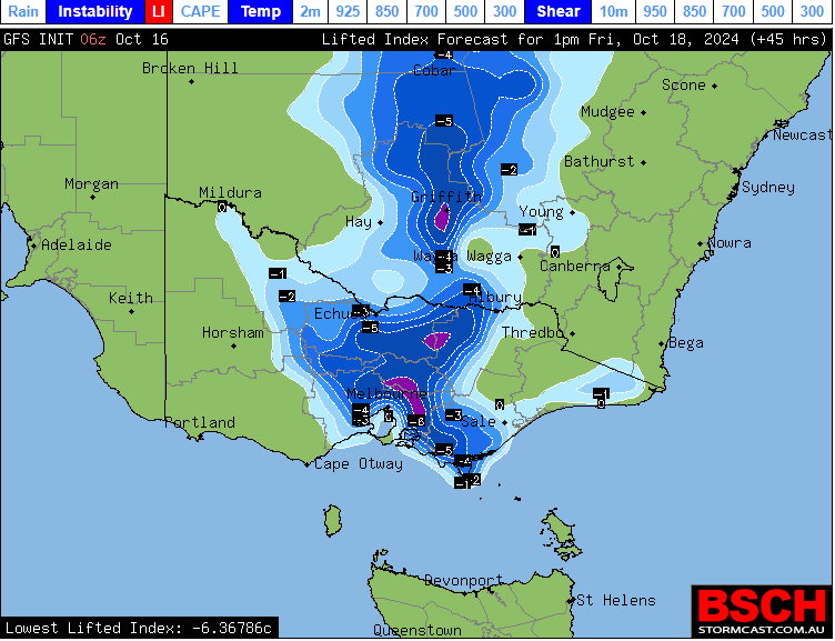 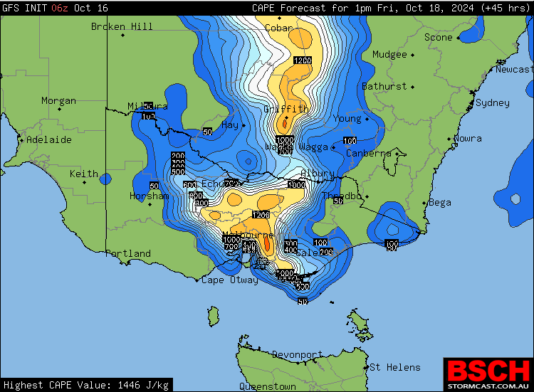 |
|
|
|
Post by greysrigging on Oct 16, 2024 15:31:08 GMT -5
|
|
|
|
Post by greysrigging on Oct 16, 2024 17:45:33 GMT -5
Broken Hill in far Western NSW about to get hammered by a monster storm cell.  |
|
|
|
Post by rozenn on Oct 17, 2024 14:46:16 GMT -5
 Med-like stationary storm line in the afternoon today for the western suburbs. Up to 70 mm SW of Paris, 20 to 40 mm in the central parts, pretty much nil in the eastern suburbs.  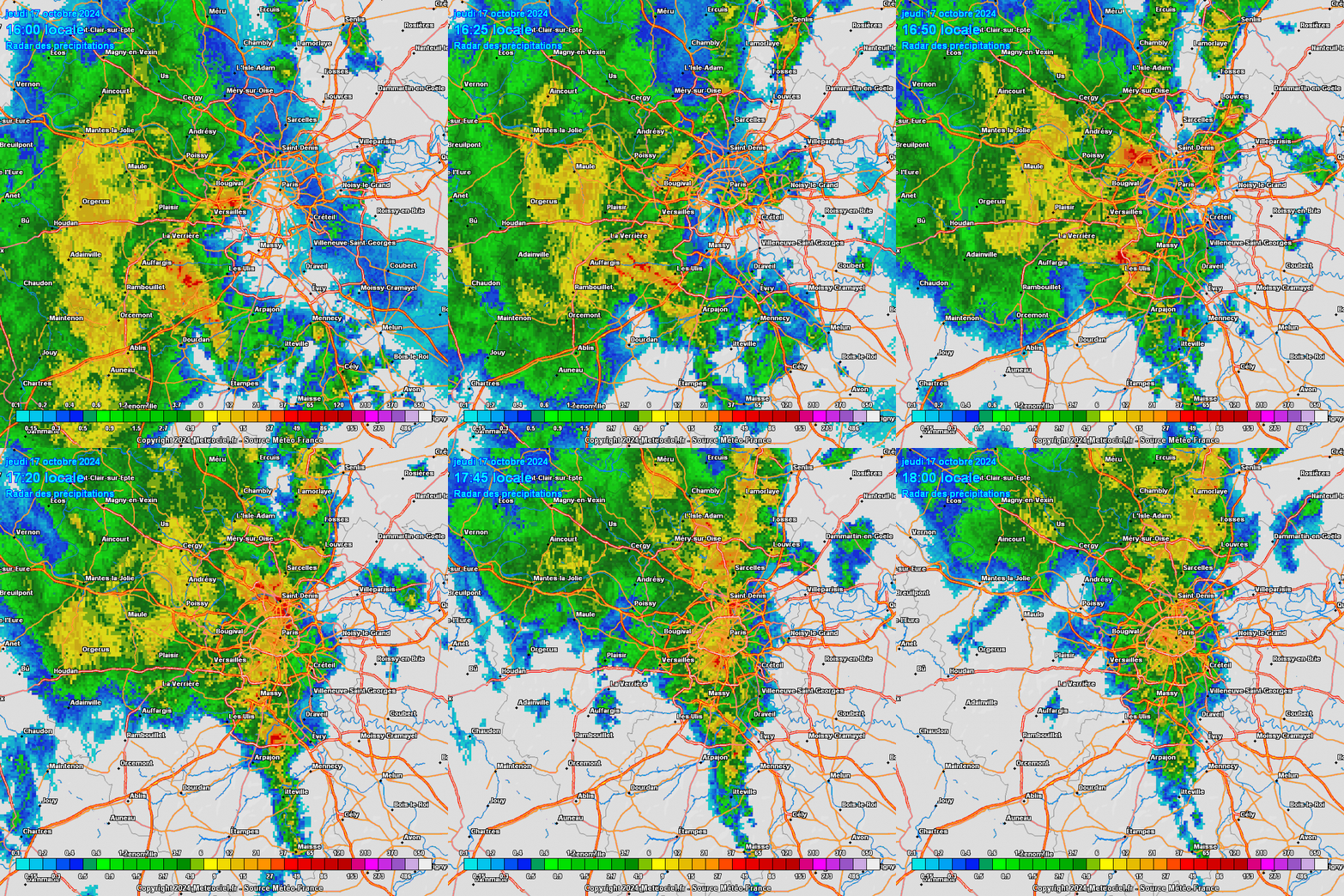 Speaking of the Med, hefty totals in parts in the mountains north of Montpellier. A bit more than 800 mm (30+ in.) in La Croix de Bauzon since Tuesday evening and counting, with October clocking 1000 mm+ so far.  Impressive storm system crossing SA and into VIC. Storm cell near Horsham, Western Victoria: She's beautiful. |
|
|
|
Post by greysrigging on Oct 17, 2024 15:52:08 GMT -5
South Australia’s highest October temperature in 29 years ( source: Weatherzone )  Coober Pedy has just registered South Australia’s highest October temperature in nearly three decades as blustery winds whip up a huge dust storm in the state’s north. Northerly winds strengthening ahead of an approaching cold front have caused a large pool of very hot air to spread through central Australia on Thursday. The hottest place in the country on Thursday afternoon was Coober Pedy in the north of SA, where the temperature reached 43.7°C shortly before 3pm ACDT. This was the highest October temperature in SA since 1995.    ^^Image: Observed minimum and maximum temperatures at Coober Pedy during the last five days. Thursday’s hot, dry and blustery winds also kicked up a massive cloud of dust from Kati Thanda–Lake Eyre and carried it towards Marree and Leigh Creek. This dust storm was so large it could be seen clearly in satellite images. A fire weather warning has been issued in SA’s North East Pastoral and Flinders fire weather districts due to extreme fire danger in the hot, dry and windy weather. |
|
|
|
Post by rozenn on Oct 17, 2024 17:10:10 GMT -5
Catastrophic rain totals in parts of the Massif Central (southern France) over the past 2 days: 866,2 mm @ Borne - La Croix de Bauzon 721,6 mm @ Vialas 688,3 mm @ Mayres 686,5 mm @ Loubaresse 657,3 mm @ Usclades-et-Rieutord 604,4 mm @ Saint-Maurice-de-Ventalon 588,5 mm @ Barnas 573,0 mm @ Mazan-l'Abbaye 566,3 mm @ Sainte-Eulalie 561,8 mm @ Villefort These range between 22" and 34" in imperial units. The leading WS is clocking 3000 mm+ (~120") YTD thanks to this. 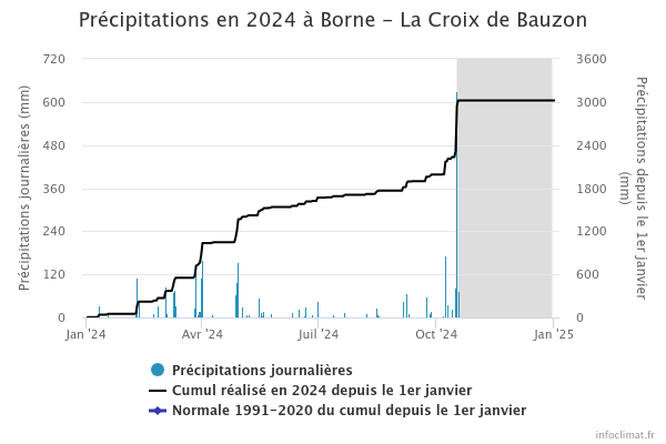 Same place, yesterday and on a "normal" day:  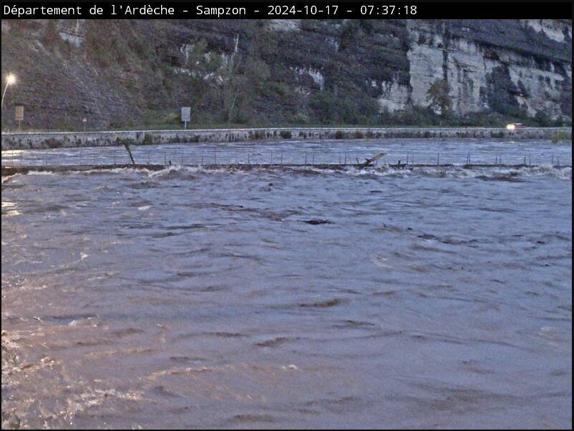 Dams are overflowing.   Infrastructure suffers. Motorway:  Railway: |
|
|
|
Post by greysrigging on Oct 17, 2024 22:53:52 GMT -5
Extreme storm system ( including supercells producing large hail, torrential rain and destructive winds ) marching across South Eastern Australia. 25.2mm in Melbourne since 9.00am   |
|
|
|
Post by Beercules on Oct 18, 2024 7:28:53 GMT -5
Severe thunderstorms affected South Australia yesterday. Notable events included 130km/h wind gusts at Roxby Downs and 137km/h at Port Pirie. But this is interesting, these temp drops at Tarcoola, during a severe thunderstorm. Oh shit, on closer inspection, it was 37.6C at 4.24pm, and 30.5C at 4.25pm, then under 20C, 5 mins later. That's insane. In Freedom Units, that is 99F at 4.24pm, 87F at 4.25pm, and 66F at 4.30pm  |
|
|
|
Post by Steelernation on Oct 18, 2024 23:24:12 GMT -5
First cold front of the month today, high was 58 (14 c) at 3 AM, didn’t get above 54 (12 c) after sunrise. Also thick overcast, I love this chilly, cloudy weather that’s still mild enough to be pleasant in a hoodie.
Fall colors are also near pick, still some green but should peak next week.
Today was the latest first sub-65 f high on record, showing how warm fall has been so far.
|
|
|
|
Post by greysrigging on Oct 19, 2024 0:58:05 GMT -5
Today's extremes in Australia:  |
|
Deleted
Deleted Member
Posts: 0
|
Post by Deleted on Oct 19, 2024 13:44:28 GMT -5
First cold front of the month today, high was 58 (14 c) at 3 AM, didn’t get above 54 (12 c) after sunrise. Also thick overcast, I love this chilly, cloudy weather that’s still mild enough to be pleasant in a hoodie. Fall colors are also near pick, still some green but should peak next week. Today was the latest first sub-65 f high on record, showing how warm fall has been so far. Nice. I also had a cool high yesterday (51.8°F). |
|
|
|
Post by Shaheen Hassan on Oct 19, 2024 16:24:59 GMT -5
We got a thunderstorm today that dropped 23.1 mm (in the nearest station). The October total runs at 32.8 mm with 9.7 mm in last Friday. Northern Qatar got some severe thunderstorms that caused serious flooding, hail and a weak tornado. All these events occurred outside station coverage. These storms are localized. In reality my area received very heavy rain last Friday that caused flooding, and heavy rain today without serious flooding, but amounts today are higher in the station.  |
|
|
|
Post by srfoskey on Oct 19, 2024 18:14:01 GMT -5
It got down to 33°F (0.5°C) in OKC and 35°F (1.5°C) in Norman last Thursday and Wednesday night, respectively. This would have been the sixth earliest first freeze on record if it had just been a few degrees cooler. Which is quite impressive given we've had such a warm fall up to this point. Above normal temps look to return in the coming days, but the climatological decline in temperatures this time of year means it will not be as hot as early October.
We're coming up on a month with no rain, with only a 20% chance on Monday night.
|
|
|
|
Post by Steelernation on Oct 19, 2024 18:25:36 GMT -5
It got down to 33°F (0.5°C) in OKC and 35°F (1.5°C) in Norman last Thursday and Wednesday night, respectively. This would have been the sixth earliest first freeze on record if it had just been a few degrees cooler. We're coming up on a month with no rain, with only a 20% chance on Monday night. Gotten colder than Fort Collins (36 f) despite being much warmer on average. Only a trace of rain this month too, interesting how it’s been rainless all across the country from New Bern to OKC to Fort Collins. Drought monitor has us in the 2nd highest category now, “extreme drought”. Just 50% of normal precipitation since April 1st with above average temps. |
|
|
|
Post by srfoskey on Oct 19, 2024 21:27:04 GMT -5
It got down to 33°F (0.5°C) in OKC and 35°F (1.5°C) in Norman last Thursday and Wednesday night, respectively. This would have been the sixth earliest first freeze on record if it had just been a few degrees cooler. We're coming up on a month with no rain, with only a 20% chance on Monday night. Gotten colder than Fort Collins (36 f) despite being much warmer on average. Only a trace of rain this month too, interesting how it’s been rainless all across the country from New Bern to OKC to Fort Collins. Drought monitor has us in the 2nd highest category now, “extreme drought”. Just 50% of normal precipitation since April 1st with above average temps. I guess the cold snap primarily affected the central part of the country then.
Somehow Cleveland County (my county) has avoided drought, while most of the rest of the state is experiencing it. I think it must be because we got about 4" of rain the last time it rained.
|
|
|
|
Post by tommyFL on Oct 20, 2024 0:17:47 GMT -5
Awesome rainfall totals in Roswell, NM...over 5" has fallen in the last few hours there, making it the wettest October day and second wettest day of any month going back to 1893. At 11 PM it was still raining and only 0.10" shy of the all-time record set back in November 1901.   |
|
|
|
Post by Babu on Oct 20, 2024 2:06:15 GMT -5
Diurnal  |
|
|
|
Post by greysrigging on Oct 20, 2024 2:56:23 GMT -5
Australia at 5.15pm Central Standard Time:  |
|
|
|
Post by tommyFL on Oct 20, 2024 16:37:24 GMT -5
Awesome rainfall totals in Roswell, NM...over 5" has fallen in the last few hours there, making it the wettest October day and second wettest day of any month going back to 1893. At 11 PM it was still raining and only 0.10" shy of the all-time record set back in November 1901. Final daily total ended up being 5.78" (148.6 mm), breaking the all-time record. |
|
|
|
Post by greysrigging on Oct 20, 2024 17:45:34 GMT -5
ABC North West Queensland 2 hours ago · ☀️🔥 HOT OCTOBER WEEK ☀️🔥 It is going to be a hot week starting today and temperatures will peak by Thursday 👇🥵 ☀️Temperatures are expected to reach well above average.👇 👉Some places will be around 7 degrees above the October average.  |
|