|
|
Post by Cadeau on Oct 31, 2024 16:43:17 GMT -5
Nothing remarkable besides flooding events on the 9th and the warmest daily record for high on the 16th. The weather has been really shitty especially in the second half of late October. Desperately craving sunny conditions right now. Paris, Île-de-France, France October 2024 Average: High 17.4°C / Low 11.5°C / Mean 14.5°CHighest: 25.9°C [16th] Lowest: 7.3°C [4th] Lowest High: 11.6°C [31st] Highest Low: 16.1°C [17th,21st] Precipitation: 131.0 mmPrecipitation Days: 13 Sunshine Hours: 97 hours 57 minutes Sunshine Percentage: 29.4% Early October: High 17.2°C / Low 11.3°C / Mean 14.3°C / Precipitation 89.3 mm / 34:09 sunshine hours Mid October: High 18.1°C / Low 11.7°C / Mean 14.9°C / Precipitation 34.9 mm / 26:58 sunshine hours Late October: High 16.9°C / Low 11.7°C / Mean 14.3°C / Precipitation 6.8 mm / 36:50 sunshine hours   - Seoul, South Korea October 2024 Average: High 21.4°C / Low 12.7°C / Mean 16.7°CHighest: 25.7°C [17th] Lowest: 7.1°C [24th] Lowest High: 15.5°C [23rd] Highest Low: 17.6°C [14th,15th] Precipitation: 74.0 mmPrecipitation Days: 5 Snowfall: 0.0 cm Snowy Days: 0 Average Relative Humidity: 69.6% Average Wind Speed: 2.0 m/s Sunshine Hours: 166.4 hours Sunshine Percentage: 47.9% Early October: High 22.4°C / Low 12.7°C / Mean 17.2°C / Precipitation 2.5 mm / 62.6 sunshine hours Mid October: High 22.3°C / Low 14.2°C / Mean 17.8°C / Precipitation 48.6 mm / 51.0 sunshine hours Late October: High 19.7°C / Low 11.1°C / Mean 15.1°C / Precipitation 22.9 mm / 52.8 sunshine hours   *Note: 3rd warmest October since record began in 1908. (3rd of 114 years: 1907-1949, 1954-present) *Note: 3rd warmest October since record began in 1908. (3rd of 114 years: 1907-1949, 1954-present)| Rank | Mean Temp | Year | | 1st | 17.9°C | 2006 | | 2nd | 17.0°C | 1998 | | 3rd | 16.7°C | 1977,2024 | | 5th | 16.5°C | 2001 | | 6th | 16.4°C | 2017,2019 | | 8th | 16.1°C | 2008,2016 | | 8th | 16.0°C | 2009 |
- Tokyo, Japan October 2024 Average: High 24.5°C / Low 17.4°C / Mean 20.6°CHighest: 31.9°C [2nd] Lowest: 11.5°C [21st] Lowest High: 17.7°C [9th] Highest Low: 22.3°C [4th] Precipitation: 174.5 mmPrecipitation Days: 12 Snowfall: 0 cm Snowy Days: 0 Average Relative Humidity: 79% Average Wind Speed: 2.4 m/s Sunshine Hours: 111.7 hours Sunshine Percentage: 32.0% Early October: High 25.7°C / Low 19.0°C / Mean 21.9°C / Precipitation 110.0 mm / 25.1 sunshine hours Mid October: High 25.8°C / Low 17.7°C / Mean 21.2°C / Precipitation 3.5 mm / 59.4 sunshine hours Late October: High 22.2°C / Low 15.6°C / Mean 18.8°C / Precipitation 61.0 mm / 27.2 sunshine hours   *Note: The warmest October since record began in 1875. (1st of 150 years) *Note: The warmest October since record began in 1875. (1st of 150 years)| Rank | Mean Temp | Year | | 1st | 20.6°C | 2024 | | 2nd | 20.2°C | 1994 | | 3rd | 20.1°C | 1998 | | 4th | 19.8°C | 2013 | | 5th | 19.6°C | 1979 | | 6th | 19.5°C | 1995,1999,2006,2011 | | 10th | 19.4°C | 2019 |
-  |
|
|
|
Post by MET on Oct 31, 2024 19:15:17 GMT -5
October 2024 Summary Westfield, South Yorkshire October 2024 was close to average in temperature and slightly drier than average. It was the first above average month since May. It exceeded my expectations after an ordinary looking first half. As is usually the case in October, there was no interesting weather. There were two bouts of low pressure. The first, at 6th-9th, was accompanied by mild conditions. The second lasted one day, 20th, with rain and wind. High pressure occurred briefly at the end, but it was cloudy. Sun was likely about average. Edit: Actually no, it was a dull load of shit.


|
|
|
|
Post by tommyFL on Oct 31, 2024 23:11:00 GMT -5
October 2024 SummarySlightly warmer than normal (+0.7 °F/+0.4 °C/67th percentile) and wetter than normal (156% of average precipitation/73rd percentile)Another windy and cloudy month with extremely boring temps. The smallest mean diurnal range of any month since records began in 2002.   New October monthly records at Port Salerno 5W COOP station (1.3 mi/2.1 km SE) (since May 2002):Record highest number of days with max temp < 85 °F (29 °C): 22 days. Previous record 21 days in 2016. New October monthly records at Port Salerno 5W COOP station (1.3 mi/2.1 km SE) (since May 2002):Record highest number of days with max temp < 85 °F (29 °C): 22 days. Previous record 21 days in 2016.Observations are from 7 AM to 7 AM Full period of record averages for Port Salerno 5W COOP station for reference: Sunshine hours at Martin County Emergency Operations Center for 2024 and averages since 2020 (calculated from solar radiation):  Allapattah Flats:  
|
|
|
|
Post by greysrigging on Nov 1, 2024 5:14:17 GMT -5
October 2024: ya 'effin' normal 'build up', so a heat and humidity month in the Top End and the beginning of summer heat in the Southern NT. Oct 2024 was the second hottest on record at Darwin Airport ( since 1941 ) and +0.7c for mins and +1.3c for max temps. And only half the average rainfall. Alice Springs was as dry as a witches tit with only 0.2mm for the month, also well above average temps both max and min ( +3.5c and +1.5c respectively ) The month Territorty wide was characterised by bushfires, weeks of heatwave warnings ( in the Top End ) and sporadic patchy storms inland of Darwin. 15 days of Oct 2024 exceeded 35c, breaking the old record of 13 such days in 2009. As per usual, the eastern Top End was also relatively dry, only 2.6mm for the month at Gove Airport in the far north east.  Rainfall - 39.4mm rainfall on 8 days ( long term mean 70.0mm, median 51.6mmmm ) Highest daily fall - 12.6mm on the 16th Max temps - 34.7c av ( long term mean 33.3c ) Highest max 36.9c on the 1st. Lowest max 29.1c on the 31st Min temps - 25.7.c av ( long term mean 25.0c ) Highest min 27.8c on the 27.8th. Lowest min 22.4c on the 31st   Rainfall - 0.2mm falling on 1 day ( long term mean 19.5mm, median 16.6mm) Highest daily fall 0.2mm on the 15th. Max temps - 35.1c av ( long term mean 31.2c) Highest max 39.8c on the 16th. Lowest max 23.7c on the 1st Min temps - 16.3c av ( long term mean 14.8c. ) Highest min 25.5c on the 16th and 17th. Lowest min 7.8c on the 2nd.  Some other monthly summaries in Northern Territory October 2024;           |
|
|
|
Post by jgtheone on Nov 1, 2024 6:11:02 GMT -5
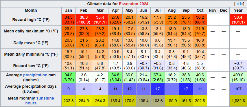
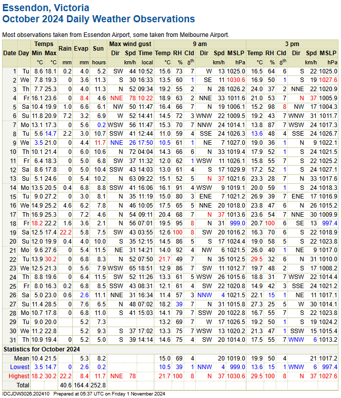
Essendon October 2024 Summary:Average max: 21.5°C (+1.0°C) Average mean: 16.0°C (+1.1°C) Average min: 10.5°C (+1.1°C) Max high: 30.2°C (22nd) Max low: 18.2°C (18th) Min high: 14.7°C (8th) Min low: 3.5°C (9th) Precipitation: 40.6mm (78.2% of avg. precip) Precip days: 11 Precip days (>1mm): 6 Sun hours: 252.8 hrs (114.9% of avg sun hours) Highest wind gust: 78km/h from the NNE (4th) October this year was above average in temperatures and sunshine, and below average in rainfall. We have had a recent lack of above average sunshine, but this month's was the sunniest since 2006 (which was also the record by a long shot). The last October with a 20C+ avg max was in 2019, so it's good to get another one. There were also a few storms this month, with a couple being severe. Overall a really good month, can't complain too much.  
|
|
|
|
Post by paddy234 on Nov 1, 2024 6:18:54 GMT -5
Perth, Western Australia (Mid Spring) Max monthly temp: 34.1°C Min monthly temp: 7.7°C Mean Max temp: 24.6°C (+1.3°C) Mean Min temp: 13°C (+1.4°C) Rainfall mm: 47.6mm (+7.2mm) Rainy days >1mm: 6 days (+0.1 days) Sunshine hours: 294.8 hours (-2.8 hours) Afternoon relative humidity: 50% It was a warmer then average month here in Perth largely due to the good number of days over 30°C which balanced out the days just above 20°C which also seemed quite frequent. Sunshine hours was bang on average and rainfall in terms of mm was only slightly more than average. The temperatures were quite up and down throughout the month mostly ranging from 20-23°C some days to 29-33°C other days. Overall a pretty average Spring for Perth www.bom.gov.au/climate/dwo/20...1.202410.shtml |
|
|
|
Post by Benfxmth on Nov 1, 2024 7:57:12 GMT -5
October 2024 SummaryVery close to normal temps with ridging dominating most of the month. A shortwave riding along a front brought a day of rainfall on the 27th spoiled the potential of the first rainless month on record, but nonetheless this October finished off as the third driest on record. Certainly no shortage of clear calm sunny days that typify fall here.    Average 2 AM temperature: 60.6°F (15.9°C) Average 8 AM temperature: 59.2°F (15.1°C) Average 2 PM temperature: 71.5°F (21.9°C) Average 8 PM temperature: 65.7°F (18.7°C) Average 2 AM dewpoint: 56.5°F (13.6°C) Average 8 AM dewpoint: 55.8°F (13.2°C) Average 2 PM dewpoint: 58.4°F (14.7°C) Average 8 PM dewpoint: 58.1°F (14.5°C) Max. dewpoint: 73.3°F (22.9°C) on the 1st, 6:58 PM; dry-bulb temperature 76.3°F (24.6°C) Min. dewpoint: 39.2°F (4.0°C) on the 17th, 2:17 PM; dry-bulb temperature 59.6°F (15.3°C) Difference between true daily mean vs. max/min / 2: -0.4°F (-0.2°C) Largest diurnal range: 29.5°F (16.4°C) on the 13th Smallest diurnal range: 6.9°F (3.8°C) on the 27th Mean time of daily high and mean daily high/solar noon timing offset (not including highs which occurred at night): 3:27 PM; +2 hrs and 33 mins No. precipitation days (>=0.01"): 1 No. precipitation days (>=0.04"): 1 No. precipitation days (>=0.1"): 1 No. precipitation days (>=0.4"): 0 No. precipitation days (>=1"): 0 Max. rainfall rate (1-min. avg.): 0.60"/hr (15.2 mm/hr) on the 27th, 4:47 PM Max. rainfall rate (10-min. avg.): 0.42"/hr (10.7 mm/hr) on the 27th, 4:43-4:53 PM Max. temperature of measurable precipitation: 57.4°F (14.1°C) on the 27th, 10:20 AM Min. temperature of measurable precipitation: 56.4°F (13.6°C) on the 27th, 7:43 PM Highest barometric pressure: 30.50 in (1032.8 mb) on the 19th Lowest barometric pressure: 29.80 in (1009.1 mb) on the 14th _______________________________________________________________________ New/Tied (Monthly) Records at New Bern ASOS (KEWN): Fewest days with >=0.01" of rain (tied with 1 from October 1987) _______________________________________________________________________ Monthly departures at New Bern ASOS (relative to 1991-2020 normals): Average high: +1.0°F (+0.6°C; 65th percentile; 26th warmest on record) Mean: +0.5°F (+0.3°C; 55th percentile; 33rd warmest on record) Average low: 0.0°F (0.0°C; 50th percentile; 37th warmest on record) Precipitation: -3.33" (-84.6 mm; 6% of normal; 4th percentile; 3rd driest on record) ________________________________________________________________________  
|
|
|
|
Post by Steelernation on Nov 1, 2024 14:22:02 GMT -5
October tied the record high and was the 2nd warmest on record following the 2nd warmest September. No precipitation fell until the 29th either. Amazing month. Average high: 71.4 (+7.1 f) Average low: 39.8 (+3.7 f) Mean: 55.6 (+5.4 f) --2nd warmestPrecipitation: 0.31" (25%, -0.94") Precip days: 3 Snowfall: 0.1" (2%, -4.0") Snow days: 1 Max snow depth: trace on the 30th Highest temp: 88 on the 2nd --T-hottestLowest temp: 30 on the 25th, 26th, 31st --T-2nd warmestHighest min: 48 on the 21st Lowest max: 46 on the 30th -Most days >70 on record (22) -Most days >85 on record (3) Other stats: > Median high: 72.0 (+0.6 from mean)Median low: 41.0 (+1.2 from mean)True daily mean: 55.0 (-0.6 f from mean)Mean dew point: 33.9 Mean RH%: 51.3% Highest dew point: 47.3 on the 20th Lowest dew point: 19.2 on the 5th Lowest relative humidity: 8.5% on the 5th (86.8 f with a 20.0 f dew) Mean wind speed: 5.7 mph at Loveland airport Max 5 minute rain rate: 0.24"/hour on the 30th Mean 3 PM temp: 69.2 Mean 3 PM dew: 30.7 Mean 3 PM RH: 27.2% Mean 9 AM temp: 51.7 Mean 9 AM dew: 34.8 Mean 9 AM RH: 54.9% Sunshine hours*: 245 hrs Sunshine percent: 71%  *= estimated from solar radiation < Month (AgMet, 00-00)  Year (Coop, 1900-1900)  |
|
|
|
Post by B87 on Nov 1, 2024 19:18:28 GMT -5
 Autumn has been very dull and very wet so far. Most of that rain fell in September, with October being slightly drier than average. |
|
|
|
Post by chesternz on Nov 1, 2024 23:32:06 GMT -5
Bangkok, Bang Na agromet. site
Lows
Highest: 27.8 C
Mean: 25.5 C
Lowest: 22.2 C
Highs
Highest: 37.2
Mean: 34.9 C
Lowest: 33.0 C
Rain
Days > 1 mm: 17
Days > 10 mm: 8
Days > 20 mm: 6
Highest 24 hr total: 86 mm
Total: 424 mm
---
Warmer and wetter than average. Decent number of storms. Overall a good month.
|
|
|
|
Post by CRISPR on Nov 2, 2024 2:09:04 GMT -5
Ulladulla 2024 October Summary:October was slightly cool, dry with above-average sunshine; and particularly stable throughout most of the month. The beginning was more interesting: with the highest maxima (27.8ºC) and lowest maxima (16.0ºC) occurring between October 7-9. However, these figures are unexceptional compared to other months. Furthermore, the middle of the month was a RETURN TO SEPTEMBER with many cool, sunny days; a few rainy days, no high exceeding 21.5ºC. However, we also recorded the warmest minima (17.1ºC) of the month. The end of the month had a mixture of dry overcast and sunny days, with the coolest minima (7.4ºC) of the month. Summaries:  Misc Stats: Misc Stats:Temperature:Mean Max: 20.4ºC ( -0.4ºC) Mean Min: 12.4ºC ( -0.1ºC) Highest Max Temp: 27.8ºC on the 7th (W, 19 km/h)- 4th lowest Lowest Max Temp: 16.0ºC on the 8th (S, 19 km/h)- 8th highest Highest Min Temp: 17.1ºC on the 19th (S, 6 km/h) Lowest Min Temp: 7.4ºC on the 26th (SW, 17 km/h) Rainfall:Total: 25.0 mm ( 28% norm)- 6 lowest Wettest day: 10.0 mm on the 15th (26 km/h S to 15 km/h S wind) No. Days ≥ 0.2 mm (9 days) ( 78% norm) ≥ 1.0 mm (7 days) ( 81% norm) ≥ 10 mm (1 day) ( 40% norm) ≥ 25 mm (0 days) ( 125% norm) Wind:Mean 9 am wind: 11 km/h ( -3.5 km/h) Mean 3 pm wind: 15 km/h ( -5.1 km/h) Max Wind Gust: 65 km/h on the 20th (9:31 pm, SSW) Calmest @ 9 am: ≤2 km/h on the 14th Windiest @ 9 am: 28 km/h on the 12th (S) Calmest @ 3 pm: 6 km/h on the 4th, 9th, 19th (NE, E, S) Windiest @ 3 pm: 31 km/h on the 13th (NE) Humidity: Mean 9 am humidity: 66% ( -2% norm) Mean 3 pm humidity: 62% ( ±0% norm) Lowest @ 9 am: 43% on the 26th (14.5ºC) Highest @ 9 am: 92% on the 18th (17.2ºC) Lowest @ 3 pm: 31% on the 7th (26.6ºC) Highest @ 3 pm: 91% on the 23rd (18.3ºC) Sunshine: (Since Ulladulla does not record sunshine manually, data was calculated from link) Mean solar exposure: 19.8 mJ / m2 ( ±0.5 mJ / m2) Lowest solar exposure: 6.2 mJ / m2 (18th, 0% possible) (0.0 hours) Highest solar exposure: 27.0 mJ / m2 (30th, 87% possible) (11.7 hours) Monthly sunshine hours: 238.4 hours (+15.2 hr) Percent possible sunshine: 59% Pressure + Diurnals:Mean Pressure: 1019.2 hPa at 9 am, 1017.1 hPa at 3 pm Max Pressure: 1031.8 hPa at 9 am (2nd) Min Pressure: 1002.1 hPa at 3 pm (18th) Mean diurnal: 8.0ºC ( -0.3ºC) Highest diurnal: 15.4ºC on the 7th (27.8/12.4) Lowest diurnal: 2.0ºC on the 24th (17.9/15.9)
|
|
Cloudy
Senior Member
  
Posts: 74
|
Post by Cloudy on Nov 2, 2024 4:33:17 GMT -5
Pretty nice month. My only issue was the absence of sub-40°F temps. Data for SeaTac: ![]()  This has nothing to do with last month, but just a reminder that I substituted missing precipitation for April 25th with data from the nearby Boeing Field station. Temperature, dewpoint and humidity data for my PWS:  My future summaries will include precipitation data. Additional stats (for my PWS): Highest min: 54.2°F on the 8th Lowest max: 49.5°F on the 30th |
|
|
|
Post by Shaheen Hassan on Nov 2, 2024 6:31:05 GMT -5
Bangkok, Bang Na agromet. siteLowsHighest: 27.8 C Mean: 25.5 C Lowest: 22.2 C HighsHighest: 37.2 Mean: 34.9 C Lowest: 33.0 C RainDays > 1 mm: 17 Days > 10 mm: 8 Days > 20 mm: 6 Highest 24 hr total: 86 mm Total: 424 mm--- Warmer and wetter than average. Decent number of storms. Overall a good month. Where can I see this info? Which days recorded precipitation? |
|
|
|
Post by Kaleetan on Nov 2, 2024 13:03:57 GMT -5
|
|
|
|
Post by chesternz on Nov 2, 2024 23:47:03 GMT -5
Bangkok, Bang Na agromet. siteLowsHighest: 27.8 C Mean: 25.5 C Lowest: 22.2 C HighsHighest: 37.2 Mean: 34.9 C Lowest: 33.0 C RainDays > 1 mm: 17 Days > 10 mm: 8 Days > 20 mm: 6 Highest 24 hr total: 86 mm Total: 424 mm--- Warmer and wetter than average. Decent number of storms. Overall a good month. Where can I see this info? Which days recorded precipitation? Mean rainfall for Oct is 289 mm, so this was a wet month. This is the data for precipitation:  |
|
|
|
Post by arcleo on Nov 3, 2024 9:51:25 GMT -5
Again, a very dry month (-2.71", 26%). Average temps but a high diurnal range (highs +2.4 °F, lows -1.5 °F) Some variability which was nice. The recent warm front was interesting.   I've really enjoyed the balance of warm and cool weather this year so far. And the mean for the first 10 months is 16.4 °C, just about perfect. I have basically no complaints other than the two dry periods, and the lack of thunderstorms. Hope November is a wetter month.  |
|
|
|
Post by srfoskey on Nov 3, 2024 16:04:08 GMT -5
I can't seem to open your link on my computer. |
|
|
|
Post by srfoskey on Nov 3, 2024 16:21:00 GMT -5
This October was quite warm and dry. It was the fourth warmest and ninth driest October on record. If it weren't for the rain on the 30th, it would've been the first rainless October (two other Octobers had a trace of precip). There were 21 days with a maximum temperature of 80°F (27°C) or higher, the fourth most on record. The last 90°F (32°C) day was on October 24, the fourth latest such day on record. We almost had a freeze mid-month, but that was narrowly averted. Most of this month was very boring, with near-constant ridging. We did have a severe weather threat on the 30th, which thankfully didn't materialize here. 2024 is now the first year since 2015 to have made it from April-October without a freeze. Which is interesting, given the long-term average last freeze is March 28, and the average first freeze is November 4.    |
|
|
|
Post by Shaheen Hassan on Nov 3, 2024 16:55:03 GMT -5
Where can I see this info? Which days recorded precipitation? Mean rainfall for Oct is 289 mm, so this was a wet month. This is the data for precipitation:  What's wrong with Bangkok? All this rain and the lowest high it achieves is 33°C? Other tropical places can achieve better. But nevertheless, I like the rainfall stats. |
|
|
|
Post by greysrigging on Nov 4, 2024 2:48:21 GMT -5
Australia's second-warmest October on record: ( source: Weatherzone )  ^^Image: Australia's second-warmest October was no laughing matter. Source: iStockphoto/tracielouise. October 2024 was Australia's second-warmest October since comprehensive nationwide records were first kept in 1910. Temperatures across the country were 2.51°C above average in terms of what the BoM calls the "national area-averaged mean temperature" – a term which simply means the average of daily maximums and minimums at hundreds of different weather stations across the country. In a strong signal of the underlying influence of the warming climate, this was the ninth month (of ten) to date in 2024 which saw nationwide temps well above average. Only April has bucked the 2024 trend with nationwide temps that were slightly cooler than average.  The list below shows the national temperature anomalies (difference from the long-term average) for all months to date in Australia for 2024: January +1.54°C February +1.71°C March +1.11°C April –0.51°C May +0.99°C June +0.71°C July +0.70°C August +3.03°C September +1.89°C October +2.51°C Meanwhile, Queensland led the way for heat anomalies in October 2024, recording its hottest October on record, with an area-averaged mean temperature that was 2.77°C above the long-term average. South Australia led the way with the biggest anomaly of 3.61°C above the long-term average, although this was not the warmest October on record (it was the fourth-warmest). It's also worth noting that all states were at least two degrees above average in terms of their statewide averaged maximums, with the exception of Tasmania where max temps were 0.99°C above the long-term average. In terms of rainfall, it was relatively dry in the most populated corner of the country, with rainfall falling slightly below average in Sydney and Melbourne, and well below average in Canberra, Adelaide and Hobart.  ^^Image: As the chart shows, areas near the southeastern capital cities all experienced drier than usual conditions in October 2024. Source: BoM. Australia-wide, rainfall was 18.4% below the long-term average in October, with the dry pattern in the southeast offset by significantly wetter-than-average conditions elsewhere, especially in large parts of Western Australia. The latest BoM outlook for the period from November to January predicts: Above average rainfall likely across large areas of eastern Australia and parts of the interior. Warmer than average days and nights likely (or even very likely) across most of Australia. Unusually high minimum temperatures likely for much of northern and eastern Australia.  |
|


 Lived:

 Residence:


