|
|
Post by Wildcat on Jun 9, 2018 9:42:24 GMT -5
Just missed out on our second 90° day of the year yesterday, max was 89. The dew point was in the upper 50s when the high was reached.
Humidity has returned today (currently 81 with a dew point of 67), and with it a chance of thunderstorms the next several days.
|
|
|
|
Post by rozenn on Jun 10, 2018 5:52:03 GMT -5
^ Lol, that sucks, looks decently warm in pretty much every direction from you too except due north. It's rather cloudy this morning here too, but strong convective clouds and then sun is out as well. Dews in the 77-79 F (25-26 C) range in the area so plenty of juice for storms later on. Jeez the same shit's happening today. Now that the low clouds have eventually buggered off, the remnants of a dying MCS are coming in. Orange tstorm warning my ass. No heat, no storms; a double whammy really. |
|
|
|
Post by Nidaros on Jun 10, 2018 6:29:43 GMT -5
Only 13 mm precipitation since mid-May here.
|
|
|
|
Post by ral31 on Jun 10, 2018 7:38:05 GMT -5
Good chance for thunderstorms here today.
|
|
|
|
Post by Ariete on Jun 10, 2018 13:43:47 GMT -5
25 days without any precipitation here.
|
|
|
|
Post by nei on Jun 11, 2018 9:43:51 GMT -5
Further north it's sunny; mix and sun and clouds. Noticed we've gotten a lot of low humidity but cloudy weather; odd combination. Must be midlevel clouds from the edge of a stalled front to the south. I'm back up in Massachusetts. Saturday was mostly cloudy with some overcast in the evening; Sunday cloudy then clearer late afternoon. Today clear blue sky. Front moved a bit south. Guessing for Vermont this month has been very sunny.  yesterday at this time clouds were stuck right at the Massachusetts-Vermont border  GOES imagery shows scattered clouds this morning; I see no clouds. Maybe early in the morning there were some clouds I didn't notice?  forecast for Amherst looks like it's getting warmer. Sun almost everyday you can see when it switched to more sun than clouds in the last week  |
|
Deleted
Deleted Member
Posts: 0
|
Post by Deleted on Jun 11, 2018 10:13:07 GMT -5
looks like the mt blanc station, colle major, went above 0C for the first time this year a couple of days ago.  |
|
|
|
Post by 🖕🏿Mörön🖕🏿 on Jun 11, 2018 10:14:43 GMT -5
27C in Churchill, Manitoba right now (10am local time). Chance of thunderstorms today.
|
|
|
|
Post by Morningrise on Jun 11, 2018 13:29:13 GMT -5
27C in Churchill, Manitoba right now (10am local time). Chance of thunderstorms today. It's 30C now with an 18C dew point. Average high for today is 10.3C. Previous record high for today was 24.4C in 1950. |
|
|
|
Post by Steelernation on Jun 11, 2018 14:17:41 GMT -5
Very low dew points the last few days. Yesterday it got as low as 38 (3.3 C) and today it’s currently 43 (6.1 C).
From 6-10 PM yesterday, 4 hours, the dew point stayed below 40 (5 C).
Not it anywhere as extreme as last year’s 27 (-2.8 C) dew in early June but still unusually low for June.
|
|
|
|
Post by 🖕🏿Mörön🖕🏿 on Jun 11, 2018 14:19:10 GMT -5
27C in Churchill, Manitoba right now (10am local time). Chance of thunderstorms today. It's 30C now with an 18C dew point. Average high for today is 10.3C. Previous record high for today was 24.4C in 1950. up to 31.2C now. Still 18C dew point. Amazing  And in Ennadai, Nunavut - it is 27C. |
|
|
|
Post by rozenn on Jun 11, 2018 17:31:52 GMT -5
11th day with thunder since May 21st in Paris.   66.5 mm (2.62 in.) today at Orly airport and 129.8 mm (5.11 in.) since the beginning of the month. That's what I call an awesome beginning to summer, fucken!     
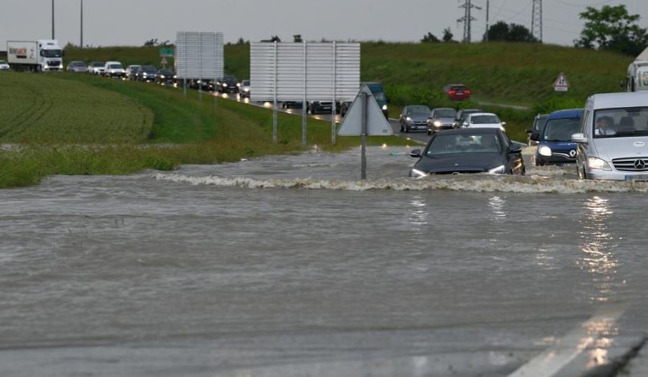
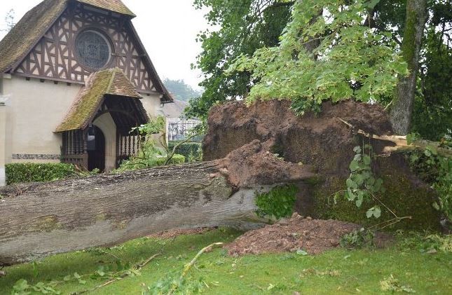
Again a large area of 50 mm+ totals today (light green to yellow tinges on the map), especially in western France:  Loads of supercell-like structures lately: www.infoclimat.fr/photolive-photos-meteo-232404-supercellule.htmlwww.infoclimat.fr/photolive-photos-meteo-232376-supercellule-hp-depuis-le-vignoble-de-morgon-beaujolais.htmlwww.infoclimat.fr/photolive-photos-meteo-232333-supercellule-et-nuage-mur.html?&start=40www.infoclimat.fr/photolive-photos-meteo-232317-supercellule-moteur-gauche-et-ephemere-dans-la-vienne.html?&start=40www.infoclimat.fr/photolive-photos-meteo-232299-supercellule.html?&start=80Nice roll cloud www.infoclimat.fr/photolive-photos-meteo-232303-nuage-en-rouleau.html?&start=40Flooding a bit everywhere, here in Chartres SW of Paris:  Tornado in nearby Cherisy apparently. This photo doesn't look like evidence for a tornado, but I like the church so I'll post it anyway. That particular village got hit by an estimated EF3 tornado back in the late 19th century.  ^ Lol, that sucks, looks decently warm in pretty much every direction from you too except due north. It's rather cloudy this morning here too, but strong convective clouds and then sun is out as well. Dews in the 77-79 F (25-26 C) range in the area so plenty of juice for storms later on. Jeez the same shit's happening today. Now that the low clouds have eventually buggered off, the remnants of a dying MCS are coming in. Orange tstorm warning my ass. No heat, no storms; a double whammy really. Eventually a supercell crossed the southern suburbs yesterday evening, bringing flash floods and damaging winds.  |
|
|
|
Post by ral31 on Jun 11, 2018 21:22:03 GMT -5
I got 0.81" of rain from a decent t-storm this afternoon. High was 92F. NWS is already forecasting high end precip chances here next Sunday and Monday with a possible tropical wave or storm.  |
|
|
|
Post by nei on Jun 11, 2018 22:25:52 GMT -5
as mentioned by 🖕🏿Mörön🖕🏿 : Churchil, Manitoba had a high 90°F today, but dropped to 64°F in 2 hours around sunset! Extremely warm plume of air further north, oddly warmer than to the south  evening temps ditto with dews clouds must have kept it cooler further south by the US-Canada border  there two trough, one centered in Albert, another offshore of Labrador. Vernon, BC got snow yesterday, from the cold. Mid 40s in Newfoundland. Warm air shot straight north in between the troughs.  |
|
|
|
Post by nei on Jun 11, 2018 22:27:43 GMT -5
Looks like that stuck Scandinavian high pressure is deflecting all their rain to you. Southern England still getting any storms? |
|
|
|
Post by 🖕🏿Mörön🖕🏿 on Jun 11, 2018 22:55:03 GMT -5
|
|
|
|
Post by rozenn on Jun 12, 2018 1:08:56 GMT -5
Looks like that stuck Scandinavian high pressure is deflecting all their rain to you. Southern England still getting any storms? Not sure, for some reasons I can't see London's pictograms nor its totals on Infoclimat. Most of the storm activity seems to have occured on the continent tho. Totals in excess of 100 mm for the last 24 hours for the eastern suburbs, an area that already got 30-40 mm from a supercell the day before! Got some more rain later in the night, though from occluded front, no more thunder.  |
|
|
|
Post by AJ1013 on Jun 12, 2018 6:04:26 GMT -5
Holy shit. Cabo San Lucas could get more rain this week than in all previous June's in recorded history combined.   |
|
|
|
Post by nei on Jun 12, 2018 9:13:36 GMT -5
Checked the temperature history; for most of the night, there was a light south wind (at least 5 mph). Air only cools to the dewpoint overnight if it's still. Dewpoint rose a bit probably as the air mixed overnight. Easier to get still air late summer & early autumn.  |
|
|
|
Post by nei on Jun 12, 2018 9:15:09 GMT -5
Holy shit. Cabo San Lucas could get more rain this week than in all previous June's in recorded history combined. Tropical remnant from an unusual early season pacific hurricane? Prevailing airflow usually pulls them away. |
|