|
|
Post by Babu on Aug 28, 2018 18:45:19 GMT -5
Biked to the coastal suburb. Very underwhelming there. This house looks stupid.  This too.  Look at this stupid ass mushroom lol. What the hell is wrong with it?  This one too. Stuff of nightmares.  These ones can actally give you nightmares.  I think this "beach" needs some weed whacking...  Sea.  River?  Seaside or riverside walk?  Pine forest.  Pine lawn  Communist apartments in the suburbs???  I wonder what the criteria for chestnuts to reproduce are. It's been an exceptionally anomalous growth season. Highly doubt they'll reproduce.  Biking home.  |
|
|
|
Post by rozenn on Aug 29, 2018 18:57:38 GMT -5
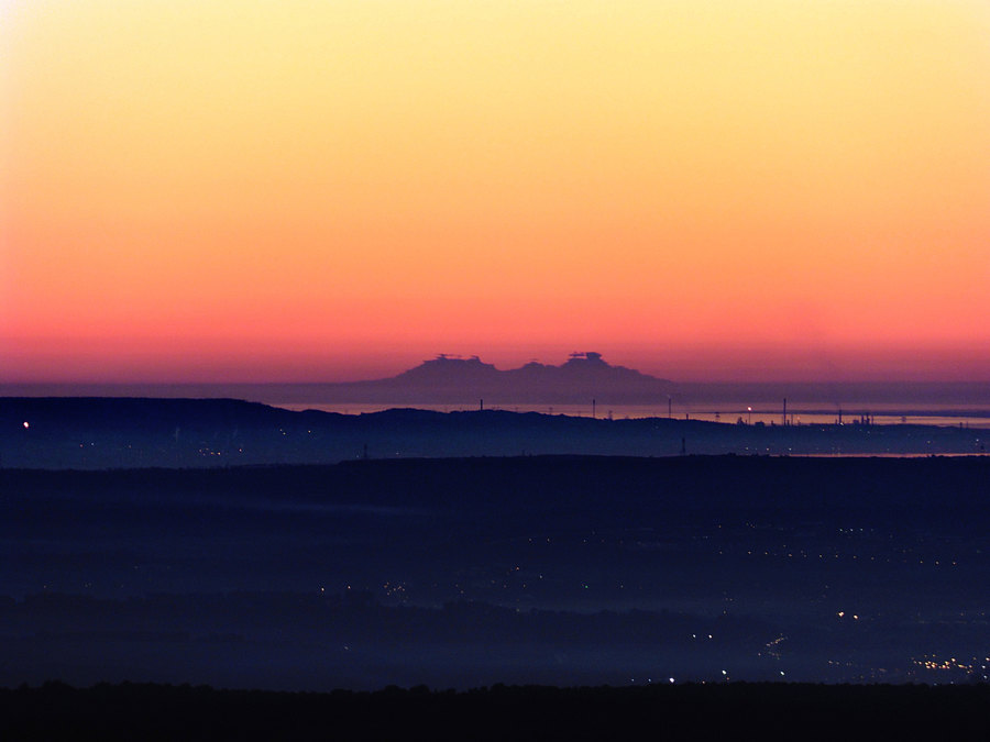
Spent a couple days in French Catalonia, mostly eating and hiking. Ski slopes look stupid in summer:  Small cirque  Did a hike the day after. Following Cambium's template: August 27, 2018 Trailhead elevation: 1620 m Top elevation: 2921 m Total elevation gain: 1419 m Distance: 23.7 km Hiking time: 5h (3h up, 2h down)   Umea might be the city of birches, but this definitely is the trail of birches!  Horse riders about to cross a cattle grid:  No trees on the south-facing slopes:    What's with all the dead trees?  Yikes!  This one's bigger still. The nearest ski resort got 621 cm (244") of fresh snow last winter, which is above average, hence the numerous avalanche tracks.  Hi!  Again?!  Pinus uncinata Pinus uncinata never cease to amaze me.  Shelter overlooking the valley. I stopped there with my dad a couple times waiting for thunderstorms to pass as a kid. The wait was terrifying.  Loads of rhodos  Large dam. Please wait a bit before breaking.  Off we go. At long last I can see my destination!   Blue dome skies characteristic of the Med area never tire me. Reaching the tundra.   Not the Everest but still a nice workout.  Getting closer  Gah  Here I am!  The real summit is a bit further south. As Owen would say, I cba.  View from there. Looking towards the east (and the Mediterranean):  Looking towards the west (and the central Pyrenees):  Large forest with a large mountain in the background.  That mountain is the last significant Pyrenean peak before the Med; one can see it from around Marseille on clear days despite the industrial fumes (a bit less than 300 km away as the crow flies):  Source: www.infoclimat.fr/photolive-photos-meteo-187168-mirage-superieur-du-canigou-12-01-2015.htmlAltitude no man's land:   Getting back to the trailhead, one can admire the avalanche tracks from further away:  |
|
|
|
Post by Wildcat on Aug 30, 2018 9:36:02 GMT -5
|
|
|
|
Post by 🖕🏿Mörön🖕🏿 on Aug 30, 2018 19:50:14 GMT -5
Relaxing by myself for what little alone time I get.  |
|
|
|
Post by urania93 on Aug 31, 2018 4:15:42 GMT -5
Autumn is coming, today the weather suddenly turned like this at about 9 am.   Basically anything above 1000 m of altitude is not visible because of clouds. When clouds are like this, sometimes, it is possible to pass above the clouds by reaching an altitude of about 1800 - 2000 m, but today I don't have the time to check if it is the case also for today. |
|
|
|
Post by Babu on Aug 31, 2018 4:26:26 GMT -5
Nice stairs.  Never seen acorns this big before. Hard to see on the picture but they're the width of my thumb.  Went to one of the kinda ancient woodland broadleaf forests in the city. Lots of dead trees there.  Very lush. I like the elderflower trees. They look exotic. And they are exotic.  Lots of ferns.  Tasty looking mushrooms. That red color signals to animals that they taste similar to strawberries.  Subtropical silt beach.  After having been a sunny day, it started to get pretty dark in the woods.  The culprit:  Got a pretty decent sunset in the end.  |
|
|
|
Post by Lommaren on Aug 31, 2018 6:31:47 GMT -5
|
|
|
|
Post by Babu on Aug 31, 2018 11:46:50 GMT -5
Nyköping looks like it could be at 65'N. Nothing but pine and birch there it seems. Sad.
|
|
|
|
Post by Lommaren on Aug 31, 2018 12:00:28 GMT -5
Nyköping looks like it could be at 65'N. Nothing but pine and birch there it seems. Sad. I actually quite like the similarities to Norrland but with a warmer climate, but I have to tell you that it's only the deep south that looks any different. If I went out in the forests of Småland pines and birch would also dominate. I think the vegetation down here is also influenced by the mini ice age of 1600-1900 and is yet to adapt to the milder climate. Either way, those forest pictures were taken at a spot that gets even colder during those rare cold snaps at below -15°C than in downtown which definitely has a lower plant hardiness.
My guess for a January normal for the location in question (2002-18) would be about 0/-6 as opposed to 1/-4.5 downtown.
|
|
|
|
Post by Morningrise on Sept 1, 2018 18:55:23 GMT -5
A bunch of random pictures I took in Saskatoon the surrounding area over the summer... First, an epic cloudscape just after sunset. On this day the temperature had hit 33C with a 21C dew point (highest heat/humidity combo I've yet experienced here) and at the time that I took this picture it was 29C with a 22C dew point. Stepping out from the cool air conditioned grocery store into the parking lot felt like walking into a greenhouse.  Next up some more heat... these next few pictures were taken on our hottest day of the year. We hit a high of 38.2C on this day and when I took these pictures a little later in the day it was still 37C. It was also quite hazy from the wildfire smoke coming from Alberta and BC.    A hare hanging around the street corner on that same 37C day, poor thing must've been quite hot...  The day after the heat, some serious smoke in town. Most of August was like this, unfortunately.   A random field at Chief Whitecap Park, a few minutes south of Saskatoon city limits. I thought the flatness and lack of trees looked cool, almost reminds me of the Mongolian steppe or something like that.  And last but not least a couple of random canola fields near Saskatoon...   |
|