|
|
Post by AJ1013 on Sept 5, 2018 16:48:14 GMT -5
is the hurricane the GFS forecast AJ1013 ? yes. I'd say it's safe to say this outcome is impossible  |
|
|
|
Post by firebird1988 on Sept 5, 2018 18:59:28 GMT -5
Today's High was 39.4°C (Normal High 39.4°C)
|
|
|
|
Post by Steelernation on Sept 5, 2018 19:08:06 GMT -5
Reached 94 (34.4 C) today, the highest September temp since 2007. The dew was also in the low 70s all day, peaking at 74 (23 C), very humid for September. This produced a max heat index of 102 (39 C), the hottest since July. This could have been even more epic but a bullshit shower at 2 PM dropped the temp from 94 to 80  After the shower, it quickly warmed back up, peaking again at 94 in the lage afternoon. I wouldn’t be surprised if it got to 95-97 (35-36 C) if we hadn’t had the stupid rain  This weekend is gonna be an unfortunate change with highs in the upper 60s (19~21 C) and rain. |
|
|
|
Post by Giorbanguly on Sept 5, 2018 19:15:04 GMT -5
Boston once again beat us with a high of 92F  Newark and LGA both capped out at 91F |
|
|
|
Post by nei on Sept 5, 2018 21:27:53 GMT -5
I'd say it's safe to say this outcome is impossible wonder if it's literally impossible, or just really unlikely like 1 in 100,000 chance per year event with the current climate. No record of such a beast in the sediment record, and sea temperatures probably can't support a hurricane maintaining that strength up there. |
|
|
|
Post by firebird1988 on Sept 6, 2018 5:05:21 GMT -5
Currently 28.9°C at 3am Pacific (Normal Low 27.8°C); with a dewpoint of 16.7°C, the Heat Index is 30°C
Forecast High is 40.6°C (Normal High 39.4°C)
|
|
|
|
Post by firebird1988 on Sept 6, 2018 19:01:00 GMT -5
Today's High was 40.6°C (Normal High 39.4°C)
|
|
|
|
Post by nei on Sept 6, 2018 22:03:14 GMT -5
omg wish I was here
|
|
|
|
Post by Giorbanguly on Sept 6, 2018 23:18:01 GMT -5
Highs today
Newark: 98F (!!!)
Boston: 97F
LGA: 96F
Philadelphia: 95F
Central Park: 93F
|
|
|
|
Post by firebird1988 on Sept 7, 2018 5:26:04 GMT -5
Currently 31.1°C at 3am Pacific (Normal Low 27.2°C); with a dewpoint of 11.1°C, the Heat Index is 30.6°C
Forecast High is 40.6°C (Normal High 38.9°C)
|
|
|
|
Post by Hiromant on Sept 7, 2018 14:31:41 GMT -5
Tallinn recorded 27,7°C today which broke the previous record for the date by 2,9°C.
|
|
|
|
Post by Steelernation on Sept 7, 2018 17:34:48 GMT -5
Today and yesterday were cooler, although still above average with highs of 79 and 78 (26 C). Lows were still well above average though.
Big chance this weekend, tomorrow is forecast at 66/49 (19/9 C), the coldest since June and Sunday is only supposed to get to 65 (18 C). Warmth returns on Tuesday with highs in the low to mid 80s for the next bunch of days.
The weekend looks dreadful though with 1.75”-3.00” (45-75 mm) predicted to fall Sunday night and Monday! Absolutely disgusting.
|
|
|
|
Post by sari on Sept 7, 2018 18:04:54 GMT -5
um so is now the time I worry about my acquaintance who literally just moved to Chesapeake, VA like a week ago? Is 895 even possible in an Atlantic hurricane? |
|
|
|
Post by Giorbanguly on Sept 7, 2018 18:41:21 GMT -5
um so is now the time I worry about my acquaintance who literally just moved to Chesapeake, VA like a week ago? Is 895 even possible in an Atlantic hurricane? I would be on my toes, but GFS also predicted 111F for Boston earlier this June... |
|
|
|
Post by alex992 on Sept 7, 2018 18:52:37 GMT -5
um so is now the time I worry about my acquaintance who literally just moved to Chesapeake, VA like a week ago? Is 895 even possible in an Atlantic hurricane? It is, Wilma reached as low as 880 mb back in October 2005. But 895 that far north is like 99.9999999999% impossible. |
|
|
|
Post by firebird1988 on Sept 7, 2018 19:01:07 GMT -5
Today's High was 40.6°C (Normal High 38.9°C)
|
|
|
|
Post by nei on Sept 7, 2018 20:09:00 GMT -5
At 2000 feet in southern Vermont; first sign of fall
|
|
|
|
Post by chesternz on Sept 8, 2018 2:30:45 GMT -5
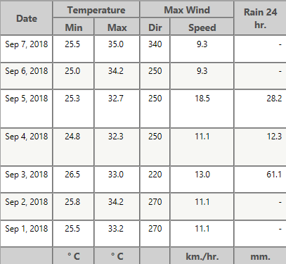
FINALLY had some decent weather here over the past week with some fairly sunny days leading to higher diurnal ranges. We've also had over 100 mm in three days and a few thunderstorms. Overall much more interesting and dynamic than the boring pattern of 27 C lows and 32 C highs with no sunshine, rain or thunder. Had a 35 C high yesterday:  |
|
|
|
Post by AJ1013 on Sept 8, 2018 2:36:32 GMT -5
FINALLY had some decent weather here over the past week with some fairly sunny days leading to higher diurnal ranges. We've also had over 100 mm in three days and a few thunderstorms. Overall much more interesting and dynamic than the boring pattern of 27 C lows and 32 C highs with no sunshine, rain or thunder. Had a 35 C high yesterday:  Ridiculously hot and humid there even compared to Miami which recorded 29C/23.5C today. |
|
|
|
Post by ral31 on Sept 8, 2018 8:30:48 GMT -5
Looks like NOAA's 7 day precip forecast showing landfall in North Carolina with 7+ inches of rain. I think the heavy rainfall across Ohio has to do with Gordon's remnants. Also quite wet in my area with 3+ inches being forecast. Daily chances at least 60% thru next Wednesday here.  |
|