|
|
Post by Babu on Nov 3, 2018 14:58:59 GMT -5
Well I'm a subtle person I guess
|
|
|
|
Post by alex992 on Nov 3, 2018 14:59:24 GMT -5
Babu , how do you think it's defined? The same as you do it, but we follow at least some kind of logic. Yeah well ours is 7 in a row below 10'C... How can yours be "the same but with logic"? Because logic wouldn't be some random arbitrary bullshit definition. |
|
|
|
Post by Babu on Nov 3, 2018 15:04:57 GMT -5
Yeah well ours is 7 in a row below 10'C... How can yours be "the same but with logic"? Because logic wouldn't be some random arbitrary bullshit definition. But... Then it's not the same  |
|
|
|
Post by alex992 on Nov 3, 2018 15:08:01 GMT -5
Because logic wouldn't be some random arbitrary bullshit definition. But... Then it's not the same  Same concept. "Autumn is when the average high drops below so and so point", which is actually logical...some bullshit like "the first 8.7 days with an average mean below 7.99999999997 C" follows no logic, it's just random shit. So while it's a similar concept....it's different execution. |
|
|
|
Post by AJ1013 on Nov 3, 2018 15:08:16 GMT -5
If I had to make up an arbitrary definition I’d say fall starts when the mean drops below 20C.
|
|
|
|
Post by Ariete on Nov 3, 2018 15:11:19 GMT -5
Babu , how do you think it's defined? The same as you do it, but we follow at least some kind of logic. Yeah well ours is 7 in a row below 10'C... How can yours be "the same but with logic"?
Ours is 10 days below 10C, but if there is a freeze, or otherwise cold weather for a few days summer is considered to be ended.
|
|
|
|
Post by Ariete on Nov 4, 2018 10:54:34 GMT -5
I'll explain this.
In early-mid September it's clearly summer whatever treshold you want to use. But during the last week there's a freeze, a couple of near-frosty nights, the highs are clearly autumnal, and there is a daily mean of only 5C on the 29th. The FMI follows the trend during 10 days, and if those 10 days generally resemble more autumn than summer, it is considered that autumn has started.
So while the FMI uses the same 10C summer treshold, it uses logic, until the SMHI, which only uses the means, and you can be "saved by the bell" over and over again when the 7th day again climbs to that 10C and the timer is reset.
|
|
|
|
Post by Babu on Nov 4, 2018 12:07:57 GMT -5
You sure it isn't a running 10-day mean above/below 10'C that's the definition?
|
|
|
|
Post by Hiromant on Nov 4, 2018 12:13:05 GMT -5
We use a five day period and local meteorologists have explained climatic seasons can flip back and forth a few times in some years with abnormal temps before they settle in. I agree because as we've seen heat waves can completely change what a month feels like. 18°C highs in October don't feel like autumn (<13°C) and now 10°C highs in November don't feel like late autumn (<5°C) so they shouldn't be qualified as such.
|
|
|
|
Post by Cadeau on Nov 4, 2018 13:15:49 GMT -5
LinkI believe the criteria which the Korean Meteorological Administration created seems pretty accurate for Humid Subtropical Climate( Cfa/ Cwa), Hot Summer Mediterranean Climate( Csa) and Hot-Summer Humid Continental Climate( Dfa, Dwa, Dsa) to determine the first day of summer and autumn. Maybe 7 consecutive days could be even better.
|
|
|
|
Post by Ariete on Nov 4, 2018 13:29:51 GMT -5
You sure it isn't a running 10-day mean above/below 10'C that's the definition?
It can be the definition, but not necessarily. The FMI says "it follows the situation for a minimum 10-day period".
|
|
|
|
Post by ral31 on Nov 4, 2018 20:28:23 GMT -5
Another severe threat tomorrow. Should be isolated in my area with higher risk to my northeast.  |
|
|
|
Post by ral31 on Nov 4, 2018 20:39:05 GMT -5
Mid-November is looking pretty nice!   |
|
|
|
Post by Babu on Nov 5, 2018 1:40:56 GMT -5
Ice and temperature chart of the Baltic sea. Cool waters right outside Umeå due to being shallow.  |
|
|
|
Post by chesternz on Nov 5, 2018 6:55:24 GMT -5
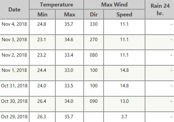
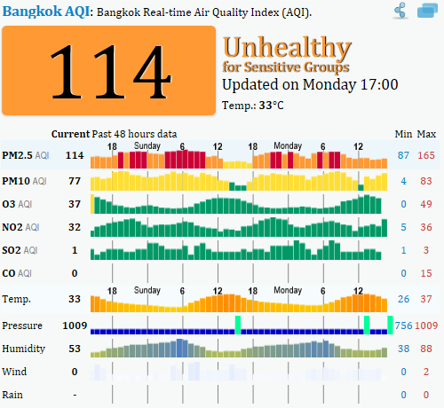
It's been a fairly warm start to the dry season here. The forecast 19 C lows (which would have been near record breaking) never eventuated (lowest was 20.7 C at DMK). Humidity was significantly reduced, mostly in the 16 - 22 C range. Overall, very sunny and comfortable outside of mid-afternoon.  Alas, with less rain comes worse air quality. No way around it, unfortunately. You just have to take the good with the bad:  |
|
|
|
Post by nei on Nov 5, 2018 12:02:56 GMT -5
haven't made many map posts. Here's this week. Cool drizzly weather today and tonight  then another system Tuesday night  slight ridge on Wednesday, downstate NY should reach 60°F; then a more zonal pattern and a slow cooling to next weekend. Zonal flow on Thursday. Midwest looks chilly  |
|
|
|
Post by alex992 on Nov 5, 2018 16:34:10 GMT -5
 Wow, I've never seen advisory map this quiet before. Essentially nothing anywhere aside from some Winter Weather Advisories out in Western Montana. |
|
|
|
Post by alex992 on Nov 5, 2018 16:35:10 GMT -5
Mid-November is looking pretty nice!   And South FL goes to fuck itself as usual. Yawn. The climate here is so fucking useless. |
|
|
|
Post by rozenn on Nov 5, 2018 17:27:52 GMT -5
Warm for the season today in Paris, with 19.7°C. I'd rather have it stay below normal by now, but it's still interesting. A chilly 4°C high in SW suburban Trappes yesterday, quite a change from the mid-20s a couple weeks ago. Didn't stick in Paris, but other regions weren't as lucky (snow does wonders when few trees if any are bare). Up to 30 cm in Saint-Etienne (500k in the metro area). Not as much snow, but still a cover in various parts of the country, from Orleans to Charleville.  <iframe width="16.399999999999977" height="9.660000000000025" style="position: absolute; width: 16.4px; height: 9.66px; z-index: -9999; border-style: none; left: 12px; top: 180px;" id="MoatPxIOPT0_95053612" scrolling="no"></iframe> <iframe width="16.399999999999977" height="9.660000000000025" style="position: absolute; width: 16.4px; height: 9.66px; z-index: -9999; border-style: none; left: 765px; top: 180px;" id="MoatPxIOPT0_96607014" scrolling="no"></iframe> <iframe width="16.399999999999977" height="9.660000000000025" style="position: absolute; width: 16.4px; height: 9.66px; z-index: -9999; border-style: none; left: 12px; top: 603px;" id="MoatPxIOPT0_79325005" scrolling="no"></iframe> <iframe width="16.399999999999977" height="9.660000000000025" style="position: absolute; width: 16.4px; height: 9.66px; z-index: -9999; border-style: none; left: 765px; top: 603px;" id="MoatPxIOPT0_91122245" scrolling="no"></iframe> Wow, is that picture from Saint-Étienne? Either way, a very early snowfall.  Sorry for the late reply lol. I don't think it's from Saint-Etienne, but a place nearby. Here are pics from Saint-Etienne posted on Infoclimat: www.infoclimat.fr/photolive-photos-meteo-236556-saint-etienne-29-30-10-2018.html?&start=200www.infoclimat.fr/photolive-photos-meteo-236569-saint-etienne-30-10.html?&start=160 |
|
|
|
Post by ral31 on Nov 5, 2018 20:00:31 GMT -5
Got pretty active this afternoon/evening in north Louisiana with tornadoes on the ground. I think the action will probably stay to my north. I think this one was about an hour to my northwest.  |
|