|
|
Post by Speagles84 on Sept 12, 2019 19:16:35 GMT -5
Nasty line of storms coming towards me right now  Did you end up getting hit with that? We got with some storms yesterday as well. Today was the very opposite of fall, we had a high of 95 F (35 C) today! Which is hot even by mid-July standards, so very hot for the time of year. And tomorrow the predicted high is only 70 F (21.1 C), quite a change! Yeah some, not as bad as the radar suggested lol |
|
|
|
Post by Steelernation on Sept 12, 2019 19:36:53 GMT -5
Only got to 66 (19 C) today, well technically the pats high was 68 at 2 AM, but still the first real crisp, fall like day.
Big rig change from yesterday which got to 85 (29 C).
The dew yesterday reached 70 (21 C), the highest since July although that is much more of an indication of how non-humid August was as dews in the 70s happen every September.
Pretty wet September so far with 1.64” already but fortunately it’s been mostly morning rain, days have been nice and sunny.
|
|
|
|
Post by Speagles84 on Sept 13, 2019 4:49:54 GMT -5
|
|
|
|
Post by Speagles84 on Sept 13, 2019 6:40:30 GMT -5
Always good to see this
|
|
|
|
Post by Giorbanguly on Sept 13, 2019 7:25:32 GMT -5
Looks like September will end on a below average note, but with nice above average temps in October for most of the peninsula. Above average temps are also predicted to last into November, though don't know if you can trust that far out web.kma.go.kr/eng/weather/forecast/long-range1.jsp |
|
|
|
Post by alex992 on Sept 14, 2019 9:40:24 GMT -5
Weather here has been a yo-yo the past couple of days; Temp at 4 pm on Thursday: 95 F (35.0 C) with sunny skies. Temp at 4 pm on Friday: 69.0 (20.6 C) with cloudy skies. w1.weather.gov/data/obhistory/KIAD.htmlToday will be in the middle of those two days, high predicted at 83 F (28.3 C) with partly cloudy skies. We're gonna have quite a warm start to next week (highs around 30-32 C for Monday) and then cool down to seasonal temps (finally!) with highs around 26 C and lows around 13 C for mid-late next week. |
|
|
|
Post by Ariete on Sept 14, 2019 11:07:20 GMT -5
Utsjoki and Kilpisjärvi today:
|
|
|
|
Post by Wildcat on Sept 14, 2019 14:14:05 GMT -5
High of 98°F (37°C) yesterday, making 7 days at or above 95°F this year, and 4 consecutive this week.
Today we’re back to seasonably warm mid-80s after yet another dry cold front. 18 days and counting with no rain.
|
|
|
|
Post by P London on Sept 14, 2019 17:12:41 GMT -5
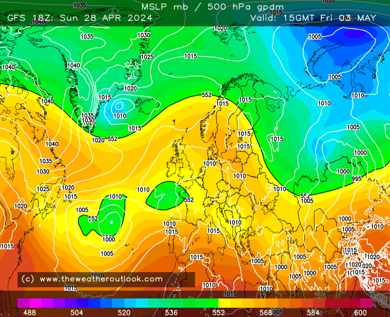
 High pressure right over the United Kingdom. Boring. I want a deep area of low pressure. |
|
|
|
Post by ral31 on Sept 14, 2019 18:46:16 GMT -5
High of 98°F (37°C) yesterday, making 7 days at or above 95°F this year, and 4 consecutive this week. Today we’re back to seasonably warm mid-80s after yet another dry cold front. 18 days and counting with no rain.Getting quite dry over the interior south. No rain for a large area since the start of September. I've only had 0.03".  Dry conditions likely to continue over the next week. Though it looks like Texas may get something tropical; hoping more of that moisture spreads east.  |
|
|
|
Post by alex992 on Sept 15, 2019 13:43:26 GMT -5
Dry heat here today, 84 F (29 C) with a 52 F (11 C) dew point, 33% humidity. Today's been an okay day, warm morning but decent afternoon with seasonably warm temps and low humidity. Tonight's low is predicted at 60 F (15.6 C).
Getting some nights in the mid 50s this upcoming week, finally some cool nights in a consistent manner.
|
|
|
|
Post by chesternz on Sept 16, 2019 8:02:10 GMT -5
Some heavy rain over the past 24 hrs:  |
|
|
|
Post by nei on Sept 16, 2019 13:42:31 GMT -5
strong ridge over the interior. Downstate NY / southern New England is at the bounday; cloudy here. See the hurricane?  slowly moving east. by the weekend will give us summer-like weather, though nothing that extreme  then back to more seasonable weather early next week  |
|
|
|
Post by nei on Sept 16, 2019 13:43:12 GMT -5
at the boundary of the ridge in stuck clouds this morning
|
|
|
|
Post by nei on Sept 16, 2019 13:44:23 GMT -5
Mt. Washington is at 35°F mid-afternoon; not summer conditions. Rather big temperature gradient with elevation, dry air below  summit had ice this morning from freezing rain? |
|
|
|
Post by rozenn on Sept 16, 2019 14:26:18 GMT -5
Rock bottom humidity this afternoon, with a 2.7°C dew point coupled with a 26.9°C air temp. Dew back to a more reasonable 15.2°C at 9 pm.
|
|
|
|
Post by AJ1013 on Sept 16, 2019 23:41:48 GMT -5
|
|
|
|
Post by Babu on Sept 17, 2019 4:50:44 GMT -5
First frost of the season. -1.9'C at the airport. Uni station got down to 1'C, so most of the city probably got ground frost.
|
|
|
|
Post by firebird1988 on Sept 17, 2019 9:16:13 GMT -5
I bet you would, I wouldn't |
|
|
|
Post by AJ1013 on Sept 17, 2019 9:59:39 GMT -5
Lows in select cities across Arizona this morming.
Yuma: 81F
Phoenix: 76F
Tucson: 65F
Flagstaff: 50F
Nogales: 59F
Lake Havasu City: 81F
|
|