|
|
Post by chesternz on May 20, 2021 8:55:17 GMT -5
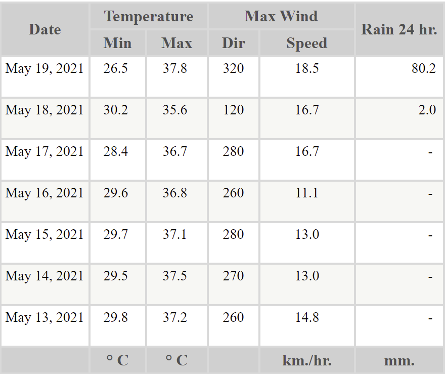
The last week has been unseasonably hot with highs around 37 C and lows barely below 30 C. Mostly sunny but yesterday downtown recorded 80 mm of rain and there was probably at least 20 mm here:  |
|
|
|
Post by Wildcat on May 20, 2021 9:38:51 GMT -5
We finally reached 80°F at LEX yesterday, with a high of 82. Only one other year (1972) took longer to hit 80 for the first time.
|
|
|
|
Post by kronan on May 20, 2021 9:50:35 GMT -5
 A cold end to May in all of western europe. |
|
|
|
Post by Benfxmth on May 20, 2021 9:58:47 GMT -5
|
|
|
|
Post by Ariete on May 20, 2021 10:11:52 GMT -5
Early-season heat continues in subarctic W. Russia.
Huh, I remembered the earliest 30C would've been recorded on the 16th.
|
|
|
|
Post by jetshnl on May 20, 2021 11:08:41 GMT -5
Calgary -1C and light snow.
Meanwhile here it’s British weather with 9C and cloudy with light rain at 11AM.
|
|
|
|
Post by MET on May 20, 2021 12:51:33 GMT -5
Horrifically GOOD thunderstorms...... more like.  |
|
|
|
Post by Babu on May 20, 2021 13:24:11 GMT -5
19.8/1.8 at the airport and 19.7/6.6 at my PWS today. I'd be comfortable assuming +0.3'C on highs and -0.3'C on lows due to slower temperature change for my PWS. On sunny days the city should be expected to be slightly warmer than the outskirts.
Umeå airport was the warmest in the country btw.
|
|
|
|
Post by FrozenI69 on May 20, 2021 14:28:17 GMT -5
Imagine waking up to this at 6 AM. Complete swampass shitshow  :  |
|
|
|
Post by Crunch41 on May 20, 2021 19:42:46 GMT -5
We finally reached 80°F at LEX yesterday, with a high of 82. Only one other year (1972) took longer to hit 80 for the first time. Saskatoon reached 90 before you reached 80. 32.6C = 90.7F. Really late for a first 80 for you, and early for 90 in Saskatoon.
Saskatoon officially hit a high of 32.6C yesterday, breaking the previous daily record of 30.6C set in 1901. Nipawin, Saskatchewan hit 33.0C which is apparently the warmest temperature in Canada this year.
Milwaukee reached 88F/31C on the 1st, which probably won't be reached this weekend but summerlike days are coming. Weather.com has 87/70 for Saturday (31/21C), NWS is milder at 86/66 (30/19).
FrozenI69 it's noticeably humid the past few days. This is the first bit of summer conditions here. It got warm in early May but the dew points were much lower. Still not going to be peak summer humidity, but it's more humid than it has been.
Da yoop is missing most of the warmth but Saturday is still forecast to reach the 80s away from Lake Superior. And apparently cooling off quickly overnight into the 30s.
|
|
|
|
Post by desiccatedi85 on May 20, 2021 20:09:25 GMT -5
Amazing weather here today, 76/60 and partly cloudy with the SE flow off the Atlantic, but still dry with 20% humidité. Most days look comfortable around 80/65 in the forecast but NWS and TWC agree on the first 90s of the summer on Sunday. Wednesday heat-wanking TWC has 94 forecast!
|
|
|
|
Post by Benfxmth on May 21, 2021 0:02:54 GMT -5
|
|
|
|
Post by rozenn on May 21, 2021 6:23:08 GMT -5
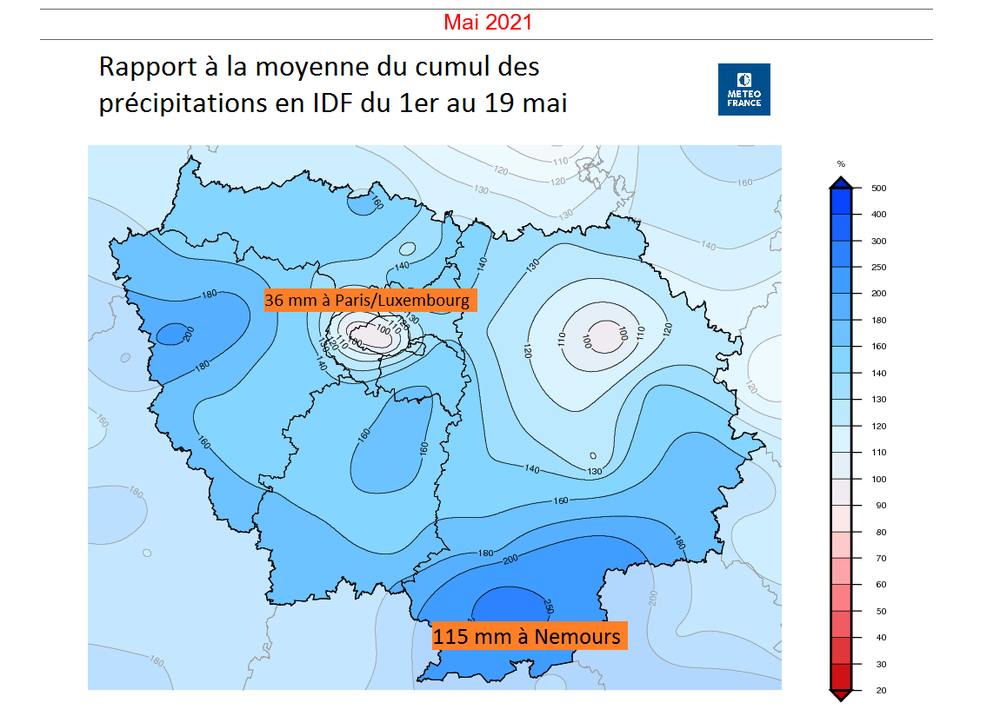
Showers are hit and miss. Ideally we'd get good frontal rain to even things out and push totals in the 100s everywhere. Paris is the dry spot in its region.   |
|
|
|
Post by Speagles84 on May 21, 2021 6:24:33 GMT -5
Heatwave continues  |
|
|
|
Post by alex992 on May 21, 2021 8:58:26 GMT -5
Today is basically a copy and paste of yesterday's weather, yesterday was 83/75 and today had a morning low of 75 F (23.9 C) and we're headed up to 83 F (28.3 C) today with sunny skies and breezy conditions. We have an elevated fire risk for today due to lower dew points (dews forecast in the 50s today) and breezy conditions.
Weather has been boring as fuck recently, and the forecast looks boring, hot, and dry as well. Not a good start to what's supposed to be the start to wet season.
On a positive note, we have a 66 F (18.9 C) forecast low on Sunday night per TWC here, which is quite cool for the time of year and definitely one of the latest I've seen mid 60s down here.
|
|
|
|
Post by Morningrise on May 21, 2021 9:50:59 GMT -5
It snowed overnight! Just three days after hitting a (rounded) high of 33C and I woke up to find my car covered in the white stuff.
Also, a strange temperature pattern in the province this morning - Uranium City, near the very northern border of the province, is the hot spot while Cypress Hills, in the relatively mild southwest, is the cold spot. Very rare to see.
And numerous parts of the south and east are under a freezing rain warning.
|
|
|
|
Post by jgtheone on May 21, 2021 19:29:47 GMT -5
My PWS recorded -0.5C this morning. I'll have to verify with other PWS in the area, but damn.
|
|
|
|
Post by Wildcat on May 21, 2021 21:46:01 GMT -5
Today is basically a copy and paste of yesterday's weather, yesterday was 83/75 and today had a morning low of 75 F (23.9 C) and we're headed up to 83 F (28.3 C) today with sunny skies and breezy conditions. We have an elevated fire risk for today due to lower dew points (dews forecast in the 50s today) and breezy conditions. Weather has been boring as fuck recently, and the forecast looks boring, hot, and dry as well. Not a good start to what's supposed to be the start to wet season. On a positive note, we have a 66 F (18.9 C) forecast low on Sunday night per TWC here, which is quite cool for the time of year and definitely one of the latest I've seen mid 60s down here. Wasn’t your forecast showing mid 90s for next week? Looks a fair bit cooler now. |
|
|
|
Post by tommyFL on May 21, 2021 21:57:44 GMT -5
Today is basically a copy and paste of yesterday's weather, yesterday was 83/75 and today had a morning low of 75 F (23.9 C) and we're headed up to 83 F (28.3 C) today with sunny skies and breezy conditions. We have an elevated fire risk for today due to lower dew points (dews forecast in the 50s today) and breezy conditions. Weather has been boring as fuck recently, and the forecast looks boring, hot, and dry as well. Not a good start to what's supposed to be the start to wet season. On a positive note, we have a 66 F (18.9 C) forecast low on Sunday night per TWC here, which is quite cool for the time of year and definitely one of the latest I've seen mid 60s down here. Wasn’t your forecast showing mid 90s for next week? Looks a fair bit cooler now. TWC clickbaiting as usual. And then they moderate it towards model consensus at the last minute to save face. |
|
|
|
Post by MET on May 22, 2021 6:38:17 GMT -5
3 weeks into May. First May failing to reach 20°C since 1983. Tying with 1996 as one of the coldest on record in this location.  |
|