|
|
Post by Benfxmth on Jun 19, 2021 2:07:17 GMT -5
In regards to the weather in Europe, the heat continues (and will continue thru the weekend) for Germany ---------------------------------------- Persistent ridging should result in sustained heat for the Italian South, the Balkans and most of eastern Europe into next week, and combined with 80°F 850 hPa temperatures, sfc temperatures near 110°F likely mid/late next week for interior Sicily; triple-digit-F temperatures should reach as far north as Romania.    |
|
|
|
Post by rozenn on Jun 19, 2021 2:35:51 GMT -5
Stovepipe Wells failed to drop below 105°F: Insane. We're nearing the World record there. Was there wind that night? It fails to cool as much as the other nights despite a similar high temp. As for me there are chances of storms today but I don't wanna jinx it as last time I posted fancy LI maps it was a major bust. |
|
|
|
Post by Benfxmth on Jun 19, 2021 2:56:01 GMT -5
Stovepipe Wells failed to drop below 105°F: Insane. We're nearing the World record there. Was there wind that night? It fails to cool as much as the other nights despite a similar high temp. As for me there are chances of storms today but I don't wanna jinx it as last time I posted fancy LI maps it was a major bust. IDK (Stovepipe Wells, which is a USCRN site, doesn't have an anemometer), though the fact that Furnace Creek recorded 8 mph winds at 11 PM suggests there was some wind (albeit in the 5-10 mph range, could be wrong) at night:  |
|
|
|
Post by Beercules on Jun 19, 2021 2:59:03 GMT -5
This June is fast becoming a gay shitheap. Cloudy, drizzle, and certainly NO crisp clear frosty morning with a nice day following. This winter is becoming the antithesis of crummer, where the highest temp was recorded in November, and the Dickcember et al was a piece of shit. Now, the coldest temp was recorded in May, and fucking nothing but shitty maritime cloud, dampness, lame half-assed showers, drizzle, and boring ass temps.  Avg Low anomolie MTD are a whopping +2.8C, due to the relentless cloud and damp malarky all the time. As a consequence, the high temp is also slightly above avg, but doesn't feel like it, because of all the stratocrapulus and other forms of overcast, not to mention the various days of Hurricane McGhee. Too bad these anomolies were nowhere to be seen in crummer when I actually care or want them, but that's our gay new age climate. Most mornings this Prune were straight out of Southern Victoria. Even forecasts of "mostly sunny" dawned overcast with even some fucking drizzle.  Ofcourse, now I get read about record breaking heat in already hot places which I could never hope to achieve, and storms for the frogs at subarctic latitudes every second day for months on end, on which I missed out on. Spot the difference. Yeah neither can I   |
|
|
|
Post by Babu on Jun 19, 2021 4:32:53 GMT -5
Large variety in lows. Latnivaara recorded a 0.0'C low and Malmö recorded a 20.4'C low.
Edit 1:Some manual stations may have been even milder, like Lund which recorded a 21.0'C low. Don't know what the record for Lund is but I don't believe it's much higher than that.
Edit 2: Apparently a lot of automatic stations aren't showing on ogimet. Hörby, far inland in Scania, at 100m, managed a 21.3'C low. I'm not sure but that could be an all-time record there. Seems clouds conveniently rolled in over southernmost Sweden after sunset keeping the temps balmy throughout the night.
|
|
|
|
Post by Babu on Jun 19, 2021 6:19:55 GMT -5
A Davis Vantage Pro 2 at 187m ASL at one of the highest points of a "bedrock ridge" in Stenestad, a bit inland of Helsingborg, recorded some pretty exceptional stats the last couple of days. The coordinates of the station points to the middle of a 100x70m grass field surrounded by trees (satellite pictures suggest the coordinates are accurate).  |
|
|
|
Post by rozenn on Jun 19, 2021 10:26:23 GMT -5
Ofc it's when you need it the most than a radar is down. Looks like a lot of strikes under that bad boy. Unfortunately it will pass me by to the west. One cell is deviating from the general flow too. Looks suspicious.  |
|
|
|
Post by dunnowhattoputhere on Jun 19, 2021 10:49:24 GMT -5
The upcoming weather pattern is very reminiscent of 2010 - hot for Eastern Europe, Finland and eastern Sweden, but cool for Western Europe.
End of June into July looks better though.
|
|
|
|
Post by Benfxmth on Jun 19, 2021 11:15:58 GMT -5
Today has turned out to be a bust thanks to high cloud. It only reached 84.4°F at my PWS (still a new warmest high of the year though), in contrast to EPS's forecast high of 86°F...and ECMWF's master run (which is usually too conservative on temps); 88°F for GFS.
|
|
|
|
Post by Babu on Jun 19, 2021 13:16:08 GMT -5
Målilla recorded exactly 34.6'C today too lol, twice in a row.
|
|
|
|
Post by Babu on Jun 19, 2021 13:18:08 GMT -5
Also, Uppsala recorded 29.6'C while Gävle, just 90km north recorded a 15.6'C high. Massive difference.
|
|
|
|
Post by Doña Jimena on Jun 19, 2021 13:21:58 GMT -5
High has been 30.2C in Riga today.  |
|
|
|
Post by Ariete on Jun 19, 2021 13:46:16 GMT -5
Heinola near Lahti was the hottest location in Finland today with 30.2C. Turku had to settle for 27.9C.
|
|
|
|
Post by ilmc90 on Jun 19, 2021 18:22:08 GMT -5
A pleasant and unexpected cool down this evening after some rain. Dropped all the way down to 65 F/18 C as of the 7PM update. At 5PM it was 83 F/28 C and the high earlier this afternoon was 88 F/31 C.
|
|
|
|
Post by rozenn on Jun 19, 2021 18:58:05 GMT -5
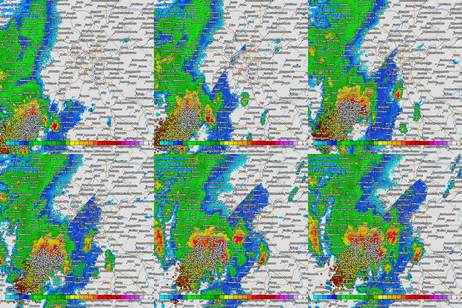
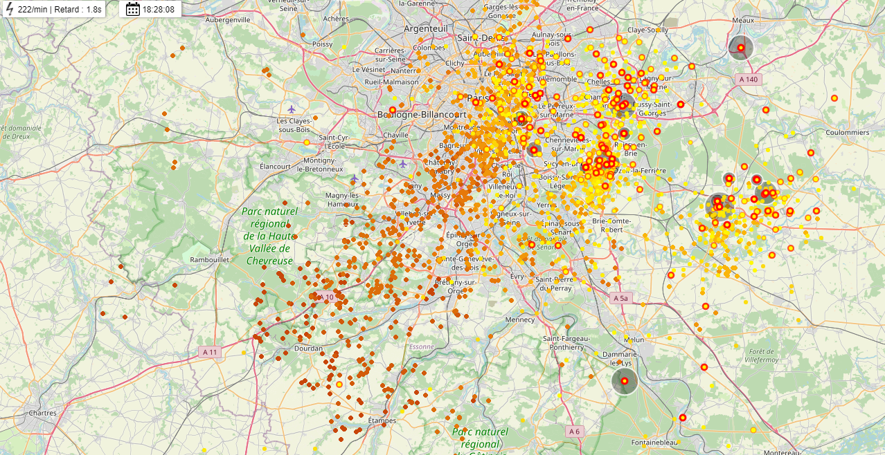
Got a healthy amount of rain today. Places in the S suburbs recorded 20 mm in 10 minutes, which is an unusual intensity for the region, as well as instantaneous rainfall rates up to 470 mm/h. Kinda hurricane-like atmosphere in places. Gusts reached 137 km/h in NE suburban Meaux. Neat vid: forums.infoclimat.fr/f/topic/56420-suivi-du-temps-en-%C3%AEle-de-france-juin-2021/?do=findComment&comment=3428471Manholes not liking it, reminds me of autumn storms on the Riviera: Aftermath Same supercell arriving in Reims; looks ominous: Quite the hailstones in this pic Tornado damage on this church spire: Lightning map for Paree  |
|
|
|
Post by rozenn on Jun 19, 2021 19:15:54 GMT -5
On another topic, pics of the noctilucent clouds of yesterday over Paris:
|
|
|
|
Post by desiccatedi85 on Jun 19, 2021 19:40:58 GMT -5
Interesting weather here today. 91/68, but it is already down to 73 as some storms are to the north and west of the area. RH spiked from 33% to 64%.
|
|
|
|
Post by Benfxmth on Jun 20, 2021 0:12:42 GMT -5
|
|
|
|
Post by greysrigging on Jun 20, 2021 0:50:43 GMT -5
A significant weather event about to impact the south west of Western Australia Wintry blast impacting WA ( source: weatherzonw ) A pre-frontal trough, supplied by a stream of moist air from the Indian Ocean, has deposited appreciable rainfall over southwestern WA. Some of the most significant falls in the 24 hours to 9am today were 61.2mm on Rottnest Island, 52.6mm at Mandurah and 41.8mm on Garden Island; these figures equate to the heaviest daily rain in about 3 years for Rottnest Island and 2 years for Mandurah. Impressively, most of this rain fell in just over 12 hours. A cold front will spread further areas of rain across the region, although the focus of the biggest totals will shift to coastal and adjacent inland areas between Margaret River and Hopetoun, where a further 20-50mm could fall by midday Monday - locally over 80mm. Meteorologists are keeping a close eye on the possible development of two low pressure systems, most likely about Perth and Albany. These lows are expected to generate some extremely gusty winds overnight tonight for coastal parts of the South West Land Division.  Image: Forecast MSLP according to ACCESS-C over southwest WA tonight; two distinct low centres are apparent near Perth and Albany, with gusty winds expected in their vicinity. Wind gusts could reach up to 100km/h over some exposed coasts, potentially even higher depending on the evolution of these lows. A gradual easing in winds is expected for most areas from the middle of Monday as the complex array of systems clears east, although a very cold airmass will spread across the region in a stiff southerly wind. The cold air will linger through the remainder of the working week and reaching as far north as the Pilbara and Northern Interior, with temperatures forecast to be widely below average. |
|
|
|
Post by jgtheone on Jun 20, 2021 2:17:44 GMT -5
This June is fast becoming a gay shitheap. Cloudy, drizzle, and certainly NO crisp clear frosty morning with a nice day following. This winter is becoming the antithesis of crummer, where the highest temp was recorded in November, and the Dickcember et al was a piece of shit. Now, the coldest temp was recorded in May, and fucking nothing but shitty maritime cloud, dampness, lame half-assed showers, drizzle, and boring ass temps.  Avg Low anomolie MTD are a whopping +2.8C, due to the relentless cloud and damp malarky all the time. As a consequence, the high temp is also slightly above avg, but doesn't feel like it, because of all the stratocrapulus and other forms of overcast, not to mention the various days of Hurricane McGhee. Too bad these anomolies were nowhere to be seen in crummer when I actually care or want them, but that's our gay new age climate. Most mornings this Prune were straight out of Southern Victoria. Even forecasts of "mostly sunny" dawned overcast with even some fucking drizzle.  Ofcourse, now I get read about record breaking heat in already hot places which I could never hope to achieve, and storms for the frogs at subarctic latitudes every second day for months on end, on which I missed out on. Spot the difference. Yeah neither can I   SE Australia in general has been very cloudy this month. Adelaide AP MTD: 80.8 hours Loxton MTD: 80.6 hours Nurioopta MTD: 62.5 hours Melb AP MTD: 46.1 hours Scottsdale, Tas MTD: 37.6 hours Lake Eildon MTD: 20.7 hours |
|