|
|
Post by jetshnl on Jun 22, 2021 16:24:55 GMT -5
a daily min of 25C in s.t petersburg. insane. Insane is right. Even in this area we can’t get lows that warm. (I think once has there been a low above 25C since 1870s) |
|
|
|
Post by Ariete on Jun 22, 2021 16:56:19 GMT -5
Finland came razor close to breaking the June national record high
Last year we recorded 33.5C in June. Seems pretty difficult for us to reach 34C, which even Trondheim has managed.
|
|
|
|
Post by rpvan on Jun 22, 2021 17:03:11 GMT -5
We *could* see a historic heatwave this weekend over the PNW. GFS and Euro have gone completely off the rails showing temps between 36c-42c (97f-108f) on Sat/Sun/Mon for most of the Vancouver region. That's completely unrealistic but the all time June record to beat for our region is 37.2c (99f), set back in 1925 so it'll be interesting to see if we get close.
|
|
|
|
Post by jetshnl on Jun 22, 2021 17:10:32 GMT -5
We *could* see a historic heatwave this weekend over the PNW. GFS and Euro have gone completely off the rails showing temps between 36c-42c (97f-108f) on Sat/Sun/Mon for most of the Vancouver region. That's completely unrealistic but the all time June record to beat for our region is 37.2c (99f), set back in 1925 so it'll be interesting to see if we get close Looks like the Manitoba early June temp is under threat. Too bad, MB hasn’t held the title for a long time. A soon to be updated table: en.wikipedia.org/wiki/List_of_extreme_temperatures_in_Canada#Yearly_Canadian_temperature_extremes |
|
|
|
Post by rpvan on Jun 22, 2021 17:12:36 GMT -5
We *could* see a historic heatwave this weekend over the PNW. GFS and Euro have gone completely off the rails showing temps between 36c-42c (97f-108f) on Sat/Sun/Mon for most of the Vancouver region. That's completely unrealistic but the all time June record to beat for our region is 37.2c (99f), set back in 1925 so it'll be interesting to see if we get close Looks like the Manitoba early June temp is under threat. Too bad, MB hasn’t held the title for a long time. A soon to be updated table: en.wikipedia.org/wiki/List_of_extreme_temperatures_in_Canada#Yearly_Canadian_temperature_extremesIf the models don't waver much places like Lytton, Kamloops or Osoyoos will blow past that reading. What the euro and gfs are showing at face value could threaten the all time provincial high temp here in BC. Doubt it verifies though. |
|
|
|
Post by rozenn on Jun 22, 2021 17:48:24 GMT -5
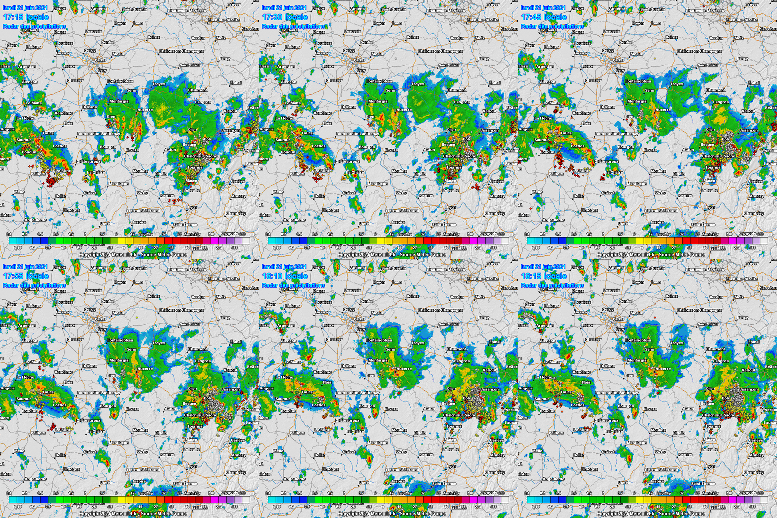
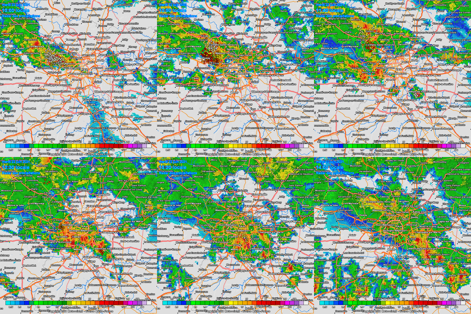
About to take off for Marseilles. Looks like I'm in for a bumpy ride.   It was seriously shaky, but not where I expected. It was only 15 minutes before landing in Marseille. Before that, the plane carefully avoided every single cumulonimbus. Looks like a supercell hit the town of Beauvais NW of Paris very hard yesterday. Totals locally above 100 mm in a couple hours from that cell: Same stuff in Reims NE of Paris, once again as that city was already flooded earlier this month: Heavy rain and some thunder today as well in parts of the metro. Daily totals likely approaching the 100 mm mark in places, once again. Meanwhile a few spots in the southeast of the region are still stuck below 10 mm since the beginning of the month!  Unusual sight on this 4-hour radar animation (maximum lenght of these GIF animations; it went for longer than that). This kind of semi-stationary line reminds me of autumn storms on the shores of the Med. The soil in the backyard has the texture of a jelly cake.  Btw just round out that the supercell responsible for macrobursts in some Parisian suburbs and a tornado in the Loire Valley also treated the town of Beauraing with another lil tornado, 500 km NE from the first one:  |
|
|
|
Post by nei on Jun 22, 2021 18:01:22 GMT -5
33c 850 mb temperatures?!
|
|
|
|
Post by rpvan on Jun 22, 2021 18:05:08 GMT -5
The GFS is definitely drunk. There is absolutely no way temps in the Fraser Valley (east of Vancouver) even hits 40c. 18z shows 44c.  |
|
|
|
Post by nei on Jun 22, 2021 18:05:37 GMT -5
Tornado death in Montreal
|
|
|
|
Post by nei on Jun 22, 2021 22:18:00 GMT -5
Very hot airmass
|
|
|
|
Post by rozenn on Jun 23, 2021 1:05:44 GMT -5
Btw there were noctulicent clouds again in Paris on Monday evening. 3rd time in one week these are visible. This is becoming a common sight lol. Here a pic from the western suburbs in front of the storm cell that flooded the streets of Beauvais:  None of that yesterday evening with the thick stratocrapulus layer. Bleak day overall apart from the midday storms; it was already 15°C and overcast at 3 pm. |
|
|
|
Post by jetshnl on Jun 23, 2021 1:09:34 GMT -5
Btw there were noctulicent clouds again in Paris on Monday evening. 3rd time in one week these are visible. This is becoming a common sight lol. Here a pic from the western suburbs in front of the storm cell that flooded the streets of Beauvais: None of that yesterday evening with the thick stratocrapulus layer. Bleak day overall apart from the midday storms; it was already 15°C and overcast at 3 pm. Neat, had those Herę as well last week. |
|
|
|
Post by Doña Jimena on Jun 23, 2021 1:33:54 GMT -5
Happy Midsummer, Priecīgus Jāņus!  The weather station of Latvian University in Riga has recorded the warmest night ever with the minimal temperature of 24.4C. The previous record of the warmest night was from 29 July 1931. Līst kā pa Jāņiem means it rains (a lot) like on Midsummer. Seems this saying will be true this year: thunderstorms are coming in from the West: |
|
|
|
Post by Benfxmth on Jun 23, 2021 2:29:07 GMT -5
nei rpvan Here's an explanation of why weather models are showing ridiculous 850 hPa temperatures:
|
|
|
|
Post by greysrigging on Jun 23, 2021 3:21:23 GMT -5
This is what a classic winter North West Cloudband does for Central Australia "Uluru has been shrouded by clouds and saturated with rain after Indian Ocean moisture took a journey across the Red Centre this week. Australia’s iconic monolith is dry for most of the year. In fact, it usually only rains at Uluru on 42 out of 365 days each year. But on Tuesday, a northwest cloudband carrying moisture-laden air from the Indian Ocean caused widespread rain across central Australia.  "The photo below from @tinabear22_ on Instagram offers a unique perspective of Uluru, with low-level cloud masking the top of the rock. It’s unusual for the atmosphere to hold enough moisture to produce a cloud-base this low over central Australia. Official observations from Yulara Airport reveal that the cloud base was below 50 metres at 9am about 300 metres at 3pm on Tuesday.  "A rain gauge at Yulara Airport, located about 18km north of Uluru, collected 10mm of rain on Tuesday afternoon. This might not seem like much, but the site’s entire June average is only 17mm. It was also enough rain to cause waterfalls on Uluru.  |
|
|
|
Post by Beercules on Jun 23, 2021 4:28:16 GMT -5
Last night and this morning it was supposed to rain but it didn't. It all went to Mildura and NW Vic, and NSW. But who cares, it's only boring light rain. Who cares.
Ended up with a nice 19C high instead. Mild low of 12C aswell. Only 15C in Mildura and 12.8C in the Hay Gays due to rain.
7/17C tomorrow with Hurricane Mcghee forecast to hit the area.
|
|
|
|
Post by Donar on Jun 23, 2021 5:22:07 GMT -5
Yesterday's highs. With meagre 13.7 °C, Aachen was by far the coldest of any bigger German cities.
|
|
|
|
Post by Speagles84 on Jun 23, 2021 6:45:05 GMT -5
Another chilly summer morning here, dropped to 43F overnight  30s all over northern PA and the mountains of PA/MD/WV, Canaan Valley might have been the coldest with a freeze on June 23rd |
|
|
|
Post by kronan on Jun 23, 2021 9:45:30 GMT -5
 Impressive contrasts in minimum temperatures over baltoscandia last night. Widespread tropical nights in the east, and widespread frost in the scandes. Coldest in Sweden was Gielas with -1.1C. |
|
|
|
Post by alex992 on Jun 23, 2021 9:48:52 GMT -5
Had a 75 F (23.9 C) low last night due to a weak storm that was in the area, rain-cooled low. As of 10 am, it's 85 F (29.4 C) with a 76 F (24.4 C) dew point, and we're headed up to 89 F (31.7 C) today with a 60% chance of thunderstorms. I think we'll get hotter than that though.
Every day in the forecast has at least a 60% chance of rain, that's promising. We're up to 5.17" (129.5 mm) when month to date average is 7.79" (195 mm) so we have some catching up to do.
|
|