|
|
Post by desiccatedi85 on Jul 25, 2021 19:14:42 GMT -5
84/68 today, partly cloudy and humid after some rain last night. 90s tomorrow and Tuesday.
|
|
Deleted
Deleted Member
Posts: 0
|
Post by Deleted on Jul 25, 2021 19:36:35 GMT -5
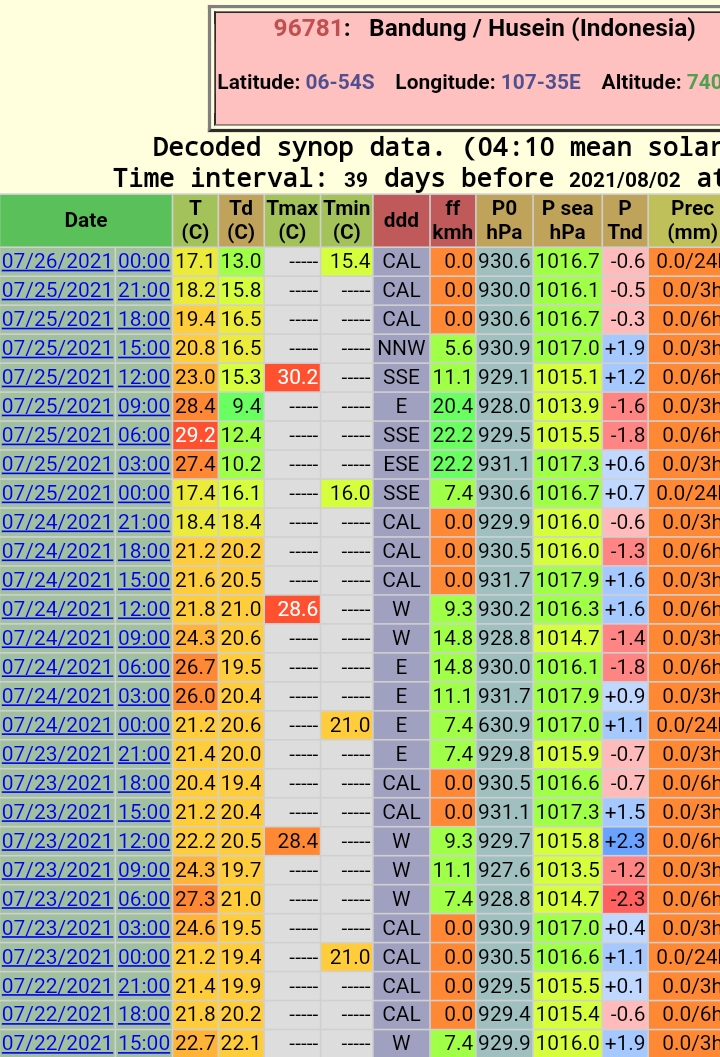
Bandung airport recorded 15.4°C this morning, which is below 60°F  |
|
|
|
Post by Beercules on Jul 26, 2021 2:24:44 GMT -5
Had a period of Hurricane Mchee today. Then tomorrow, comes Hurricane McGhey. 50Km/h winds predicted, which in Renmark means rediculous stupidity. Got fucking damn it this NEVER ENDING FUCKING WIND IS DRIVING ME MAD - THE WHOLE RECORD COLD CRUMMER, AND NOW  Forecast high is atleast 23C , and today was 19.8C with sunshine. So there is a atleast a break from the damn cloud and the skin penetrating northern European November damp shit. |
|
|
|
Post by chesternz on Jul 26, 2021 5:39:06 GMT -5
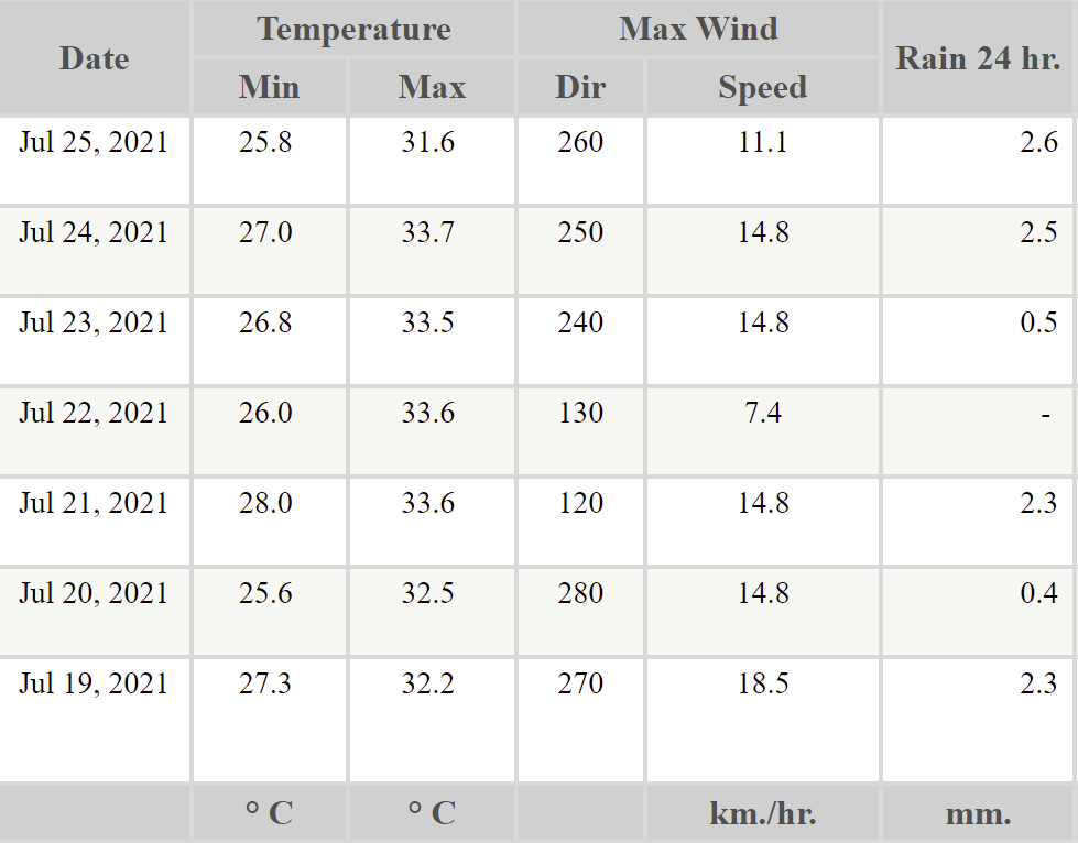
Boring as hell last week. It rained on six days but never more than 3 mm. And it was pathologically cloudy with no storms:  Pretty notable dewpoint drop at Bandung airport. Almost 6°C drop in 3 hours between 7-10am 10°C drop in 9 hours Damn, warmed up quickly, too!  How does it peak at 6 AM? |
|
Deleted
Deleted Member
Posts: 0
|
Post by Deleted on Jul 26, 2021 5:56:20 GMT -5
Boring as hell last week. It rained on six days but never more than 3 mm. And it was pathologically cloudy with no storms:  Pretty notable dewpoint drop at Bandung airport. Almost 6°C drop in 3 hours between 7-10am 10°C drop in 9 hours Damn, warmed up quickly, too!  How does it peak at 6 AM? It's 06:00 UTC, which is 13:00/1PM local time |
|
|
|
Post by Morningrise on Jul 26, 2021 7:34:36 GMT -5
Finally getting a bit of rain this morning! We've only had 6.7mm this month, and while we definitely won't get a significant quantity today it's still better than nothing.
|
|
|
|
Post by nei on Jul 26, 2021 15:28:06 GMT -5
come home to wildfire smoke; west is nicer
|
|
|
|
Post by rozenn on Jul 26, 2021 18:46:33 GMT -5
Paris area got some storms today. I got some a strong shower yesterday where I am in the Dordogne area. Nice monthly totals again in parts of the Paris metro. For example 136 mm / 5.37" mtd @ Le Bourget airport in the northern suburbs: www.infoclimat.fr/climatologie-mensuelle/07150/juillet/2021/le-bourget.htmlNeedless to say, everything is nice and green, in sharp contrast with the three previous summers, be it in Paris or here in Dordogne, despite the 5-day stretch of 90°F+ weather. |
|
|
|
Post by desiccatedi85 on Jul 26, 2021 20:33:02 GMT -5
90/72 here today and partly sunny. DP down to 55 degrees as well which is very nice, loving this dry heat. More of the same tomorrow! Wildfire smoke here not nearly as bad as last week, but still hazy blue skies.
|
|
|
|
Post by FrozenI69 on Jul 26, 2021 21:44:40 GMT -5
Been hot the past 2 days with highs in the 90's but thanks to lower dews, it's a bit more tolerable in the morning hours.
|
|
|
|
Post by Speagles84 on Jul 27, 2021 5:57:20 GMT -5
2021 Daily observations so far  Everyone in the northern hemisphere knows what is next  |
|
|
|
Post by Beercules on Jul 27, 2021 6:07:42 GMT -5
22.9C here today  ofcourse, it had to be accompanied by Hurricane Mcghee, but Hurricane McGhey did not show up. One of the tamer days in recent memory if anything. Still 21C @ 8.30pm. Don't get that too often in a winter as shit as this! |
|
|
|
Post by Doña Jimena on Jul 27, 2021 7:49:51 GMT -5
Bad weather is coming from England to France.  Very Atlantique weather in Bordeaux, feels like September, overcast with some drizzle, low 14.8C. At 2 p.m. it has barely got above 20C with 20.8C and more than 90% of humidity. It must be 15C in London, I guess. P.S. People in general are very friendly here, nicer than in Paris and seem to adore tourists, many want to speak English...  |
|
|
|
Post by Met.Data on Jul 27, 2021 7:52:34 GMT -5
Bad weather is coming from England to France.  Very Atlantique weather in Bordeaux, feels like September, overcast with some drizzle, low 14.8C. At 2 p.m. it has barely got above 20C with 20.8C and more than 90% of humidity. It must be 15C in London, I guess. P.S. People in general are very friendly here, nicer than in Paris and seem to adore tourists, many want to speak English... The wind is coming from the SW in the UK, so not going to France, but from France; and the temperature in London is 22°C, and 21°C here. The wind in Bordeaux is coming off the Bay of Biscay.... |
|
Deleted
Deleted Member
Posts: 0
|
Post by Deleted on Jul 27, 2021 8:04:17 GMT -5
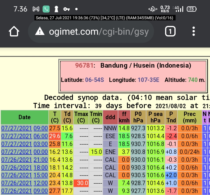
 This morning had a 15.0°C low at Bandung airport station as well as a 7.6°C dew point at 13:00 local time (06:00 UTC)... No data for today's high yet but there's possibility of 30.0°C or higher considering the 13:00 temp was 29.6°C - which means a possible 15°C+ diurnal |
|
|
|
Post by Doña Jimena on Jul 27, 2021 8:12:46 GMT -5
Bad weather is coming from England to France.  Very Atlantique weather in Bordeaux, feels like September, overcast with some drizzle, low 14.8C. At 2 p.m. it has barely got above 20C with 20.8C and more than 90% of humidity. It must be 15C in London, I guess. P.S. People in general are very friendly here, nicer than in Paris and seem to adore tourists, many want to speak English... The wind is coming from the SW in the UK, so not going to France, but from France; and the temperature in London is 22°C, and 21°C here. The wind in Bordeaux is coming off the Bay of Biscay.... The wind is blowing from SW indeed, but at a higher level, the jet stream is coming directly from Greenland to northern Spain which explains the Septemberlike weather. Next days look warmer and sunnier at least. |
|
|
|
Post by Met.Data on Jul 27, 2021 8:19:18 GMT -5
The wind is coming from the SW in the UK, so not going to France, but from France; and the temperature in London is 22°C, and 21°C here. The wind in Bordeaux is coming off the Bay of Biscay.... The wind is blowing from SW indeed, but at a higher level, the jet stream is coming directly from Greenland to northern Spain which explains the Septemberlike weather. Next days look warmer and sunnier at least. Jetstream has moved south, but it's not even flowing over the UK at this point, so it's driving low pressure from the west not from here; but it will move eastwards to cover the UK by late tomorrow. |
|
|
|
Post by Benfxmth on Jul 27, 2021 10:28:59 GMT -5
Meanwhile in Rome...Ciampino AP recorded an overnight low of 83.5°F Sunday night thanks to high clouds, and wind.   |
|
|
|
Post by greysrigging on Jul 27, 2021 16:37:18 GMT -5
The record breaking July heatwave continues across the Top End of the Northern Territory. Jabiru, the former service town for Ranger Uranium Mine ( within Kakadu National Park ) has a series of 37c max temps forecast to end the month. The site is running at 2.1c and 1.7c above the July mean max and min temps. Also running 0.4c above the previous July monthly record of 33.8c set in 2017. Site has data back to 1971.   |
|
|
|
Post by greysrigging on Jul 27, 2021 17:00:16 GMT -5
BOM NT predicts early onset of wet season build-up as July temperature records fall ( source: Weatherzone ) People in the Top End are being warned to brace for an early return to sweatbox conditions, with predictions an early onset of the wet season will bring the cooler dry season temperatures to a premature end. Bureau of Meteorology (BOM) modelling shows rain and high humidity levels are expected to envelop some parts of Northern Australia earlier than usual. Forecasters say the pre-wet season conditions known locally as the build-up where soaring humidity propels many areas into sauna-like conditions ? could begin as early as September. The driver behind the conditions is a phenomenon known as the Indian Ocean Dipole, which was recently declared negative for the first time in five years. That means central and southern parts of the country will become wetter throughout the colder months of the year. BOM senior forecaster Billy Lynch said it could also lead to early wet season downpours in the Top End. "The rain that we would normally expect to experience during that September, October, November period could come earlier this season," he said. "The prospects of seeing some rain in the Top End from September onwards is more likely." Temperature records tumble Some parts of the Northern Territory have also sweltered through a scorching July, with record-breaking temperatures. On July 25, the remote community of Wadeye reached 35.6 degrees Celsius its hottest July day in more than 20 years. In Victoria River Downs, a cattle station about 700 kilometres south of Darwin, a 37.7C day became the hottest maximum July temperature in 56 years. Mr Lynch said July temperature records in Central Australia could also tumble in the coming days. "We're expecting to see that heat move southwards into central and southern NT, so we could even see some records across the south." Alice Springs is forecast to have its hottest July day, at 32C, on Friday. Cooler temperatures will bring relief to southern and central parts of the NT from Sunday. The Top End will have to wait a bit longer, with a cool change not expected until the middle of next week.  |
|