|
|
Post by srfoskey on Nov 13, 2021 21:03:27 GMT -5
Peak foliage in Boston right now Norman is at or past peak. I'm impressed that we're progressing at a similar speed as Boston.
We did have our first freeze this morning, with a low of 30°F (-1°C).
|
|
|
|
Post by Ethereal on Nov 13, 2021 21:19:09 GMT -5
Nice temperature discrepancy in the southeast (although it's not as impressive as it was last month):  |
|
|
|
Post by knot on Nov 13, 2021 23:30:25 GMT -5
So far, a max temp of 6.6° C here. I note a rather high LCL—of about 900 m (I'm only barely inside the cloud base). Steep lapse rates as a result: Cabramurra mostly 5+ °C cooler than here today (max 1.4° C), so approx. 1° C / 100 m.
[UPDATE as of 3:50 PM]: temp spiked to 7.5° C here and 2.8° C at Cabramurra recently, but dropped back down.
|
|
|
|
Post by rozenn on Nov 14, 2021 8:53:09 GMT -5
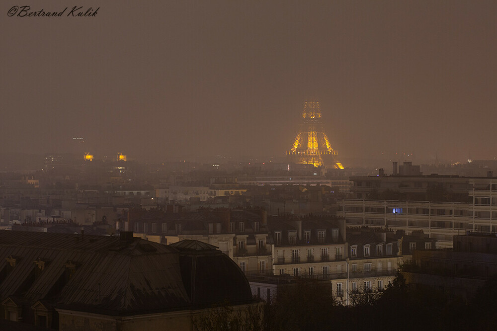
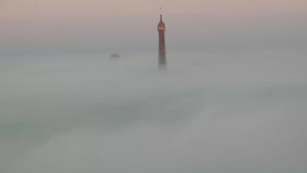
Anticyclonic weather these past few days, which, this time of year, means random patches of fog staying all day in places and dissipating in others. Made for nice pics:   Places where fog stayed all day long could be spotted on the max temp map of central-northern France on a couple days. The Paris area is the place where maxes ranged between 4°C and 12 °C over a couple dozen kilometers:  |
|
|
|
Post by rpvan on Nov 14, 2021 18:00:53 GMT -5
Significant atmospheric river event moving through southwestern BC, began yesterday evening and lasting through tomorrow afternoon.
48hr rainfall totals throughout the Vancouver region will be in the 100-200mm(4-8") range by tomorrow evening. Potentially higher amounts, up to 250mm(10"), in the eastern fraser valley and north shore, along the coast mountains.
Already seeing flooding, rockslides and mudslides in some areas in the region.
|
|
|
|
Post by Ariete on Nov 14, 2021 18:09:07 GMT -5
Rather cold today with a 3.4C high and a -2.8C low. But it was sunny almost all day, which was nice.
|
|
|
|
Post by greysrigging on Nov 14, 2021 20:55:50 GMT -5
SNOWVEMBER! Mountains coated in white two weeks out from summer ( Source: weatherzone )  Image: Thredbo on November 15, 2021, five days before mountain bike season, not ski season! Source: Simone Griffin. A strong cold front has lashed southeastern Australia, bringing strong winds, cold temperatures, hail, rain and yes, even snow to the mountains. Weatherzone meteorologist Chris Matthews told us yesterday that a dusting of snow had sprinkled the ground, but that dusting has turned into a "dump", with locals reporting around 20 cm up high and 10 cm or thereabouts down in the valleys in places like Thredbo Village. Snow is, of course, far from unknown in the Australian High country in late spring or even in the summer months, as Southern Ocean cold fronts can push northwards in any season. But it's far less likely at this time of year, and especially in this quantity. But if you take a look at the current satellite image overlayed with the synoptic chart, you can see the cold southerly flow at work, with the tell-tale speckle cloud that usually accompanies a strong cold front.  As you'd expect, temps were frigid across the Australian Alps, and when you factor in the wind chill, the apparent temperature (effectively what it feels like to be outside factoring in air temp, relative humidity and wind speed) some of the readings were pretty extreme, and still are. For example, as we write this at 10:30 am on Monday morning (AEDT): Thredbo top station (NSW, elevation 1957m) was sitting on -4.3°C with wind gusts approaching 100 km/h and an apparent temp of -20.1°C Perisher Valley (NSW, elevation 1720m) was -2.0°C with gusts around 80 km/h and an apparent temp of -13°C. Mt Buller (Vic, elevation 1707m) was sitting on -3.5°C with gusts around 50 km/h and an apparent temp of -11.7°C. Several minimum temp records appear to have been broken in Tasmania, and Hobart's low of 2.9°C was its coldest November reading since 1953. Unsurprisingly with such cold temperatures, the snow level in Tasmania was low for any season, let alone November. This was the scene at Mountain River near Hobart, at an elevation of just 360m.  The mountain weather should start to clear tomorrow in Tasmania and on the mainland. That’s good news for hikers like Simone Griffin, who is currently undertaking the Australian Alps Walking Track (a 670 km trek from the ACT to southern Victoria) who is currently holed up in Thredbo waiting for the snow to melt. The pics of Thredbo village in this story are hers.  Image: They don't call then snow gums for no reason: Source: Simone Griffin. Meanwhile the strong winds that have lashed Tasmania, Victoria and southern NSW should start to ease across inland areas today, although parts of the NSW coast, including Sydney, have gale warnings in force today, and strong wind warnings in place for Tuesday. Aside from the strong winds, the southeast will stay cool and mainly dry for the first part of this week, before warmer unstable weather arrives around Thursday. |
|
|
|
Post by greysrigging on Nov 14, 2021 21:25:47 GMT -5
|
|
|
|
Post by Steelernation on Nov 14, 2021 22:14:58 GMT -5
High was 72 (22 c) today with mostly sunny skies so I guess I was wrong about last Sunday being the last 70 f.
Mild night, still 63 (17 c) at 8 PM.
|
|
|
|
Post by knot on Nov 14, 2021 22:34:51 GMT -5
|
|
|
|
Post by greysrigging on Nov 15, 2021 4:10:23 GMT -5
Record-breaking late-season cold spell hits southeastern Australia ( source: Weatherzone )  If you think it's been unusually cold in southeastern Australia during the last few days, you're not imagining it. Some places just endured a late-season cold spell not seen for more than 160 years. A mass of cold air has been driven over Australia’s southeastern states during the last few days by a strong low pressure system. The satellite image below shows a large mass of speckled clouds within this cold air mass on Monday.  Image: Himawari-8 satellite image captured at midday AEDT on Monday, November 15. This weather pattern is more typical of winter than late-spring, and it has brought a string of cold days that are rarely seen this late in the year. Melbourne’s maximum temperatures during last four days have been well below the long-term November average of 22ºC, reaching: Friday: 14ºC Saturday: 14.6ºC Sunday: 15.3ºC Monday: 13.5C (running max. as of 6pm AEDT) This is the first time in 167 years of records that Melbourne has had four days below 15.5ºC this late in spring.  Further north, Canberra’s last three days have been around 10ºC below average for this time of year: Saturday: 13.4ºC Sunday: 14.0ºC Monday: 13.9C (running max. as of 6pm AEDT)  Image: Canberra's minimum and maximum temperatures during the last five days, as of 6pm AEDT on Monday. This is the first time in 99 years of records that Canberra has had three days at or below 14.0ºC, this late in spring. Temperatures will warm up during the next couple of days as the low pressure system moves east, towards New Zealand. |
|
|
|
Post by jgtheone on Nov 15, 2021 7:38:28 GMT -5
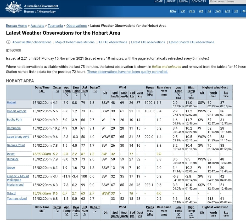
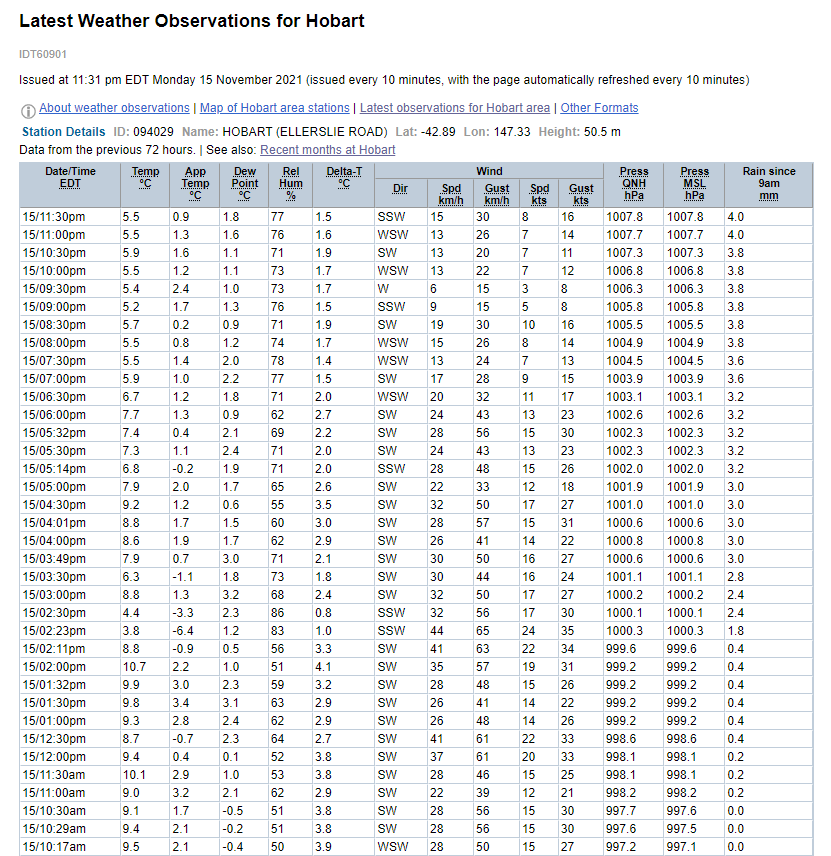
I wasn't exaggerating with that 1880s comparison. I was being too kind. It's like the equivalent of that 1867 May from Helsinki or whenever it averaged 5C maxes. Here's some obs from Hobart today.   |
|
|
|
Post by jetshnl on Nov 15, 2021 10:05:58 GMT -5
I wasn't exaggerating with that 1880s comparison. I was being too kind. It's like the equivalent of that 1867 May from Helsinki or whenever it averaged 5C maxes. Here's some obs from Hobart today. The 9am reset should sort out that low max yesterday. |
|
|
|
Post by Steelernation on Nov 15, 2021 12:16:56 GMT -5
Had some chinook winds last night, temps oscillated between the 50s and windy periods bringing them into the mid 60s.
Some notable temps:
1:40 AM: 66 f (19 c)
3:00 AM: 65 f (18 c)
4:20 AM: 67 f (19 c)
Those temps are 40 f above average for the time of day!
It ended up dropping to 49 (9 c) a little after 6 AM, which just missed the November record by 1 f.
Still the 2nd warmest November low ever!
|
|
|
|
Post by Doña Jimena on Nov 15, 2021 13:27:31 GMT -5
Coldest day so far in Riga, min -2.2C, high 1.2C. Fog all day and massive hoarfrost on grass, trees. At least one flight, the flight from Copenhagen could not land in Riga and was redirected to Kaunas.  |
|
|
|
Post by 🖕🏿Mörön🖕🏿 on Nov 15, 2021 13:35:59 GMT -5
Awesome sight. The climate is changing and it won't be for the warmer. |
|
|
|
Post by knot on Nov 15, 2021 16:58:42 GMT -5
Down to as low as 0.2° C earlier this morning. Yesterday maxed at 7.2° C, and the day before at 7.5° C; precipitation for the event (11–15 Nov) totalled 142.6 mm, bringing my monthly and yearly totals up to 206.2 mm and 1,786.3 mm respectively.
|
|
|
|
Post by Speagles84 on Nov 15, 2021 17:25:52 GMT -5
|
|
|
|
Post by Steelernation on Nov 15, 2021 23:55:47 GMT -5
High was 70 (21 c) today, now probably the last one of the year.
Down to 48 (9 c) at 9:40 PM, actually the one time the 7 PM-7 PM “day” is good as it preserved last nights low.
Looks like the first real cold night of the year coming up Wednesday with forecast lows in the 10s. Still no real cold days and snow though.
|
|
|
|
Post by 🖕🏿Mörön🖕🏿 on Nov 16, 2021 0:36:38 GMT -5
Even windy at the airport, which is usually a deadzone (relatively) compared to my location.  |
|