|
|
Post by Met.Data on May 13, 2022 6:10:30 GMT -5
Did we ever get lucky. Managed to dodge the heat afflicting Gayrope! I can imagine heat lovers would be crying into their beers about that though!  I know pre-2020 Meteoman would be MAD - and so would I! Hahaha yeah true. |
|
|
|
Post by Benfxmth on May 13, 2022 6:10:41 GMT -5
The curse of the English Channel, this is a polar Raw-me getting oceanic AIDS shit with Paree getting warmth and sunshine all around situation.
|
|
|
|
Post by Met.Data on May 13, 2022 16:14:58 GMT -5
It will still get warm in London for at least 6 hours dou.  |
|
|
|
Post by nei on May 13, 2022 18:03:59 GMT -5
Cool marine layer shot
hot and dry interior + cold ocean = marine layer
|
|
|
|
Post by ral31 on May 14, 2022 7:51:32 GMT -5
Tied or surpassed record highs multiple days this week. Hottest temp so far has been 95F.
Then got strong storms yesterday evening after getting up to 94F. Saw the most hail I've seen in a while (around dime sized) and had a good bit of lightning. The storm formed developed and became severe-warned right over my location. The airport hardly got anything.
Slightly cooler today with another chance of storms. Then back up to near record breaking temps in the mid-90's next week.
|
|
|
|
Post by desiccatedi85 on May 14, 2022 8:58:07 GMT -5
Cool marine layer shot hot and dry interior + cold ocean = marine layer Same setup here in spring as in SoCal during our onshore flow events. Just less pronounced due to not having a cold ocean current and a literal desert inland. |
|
|
|
Post by Morningrise on May 14, 2022 17:12:24 GMT -5
We got 9.5mm of rain yesterday, our wettest day since August 23rd last year. That was nice, especially since the forecast had been downgraded from rain to a chance of showers.
The province is in a weird situation at the moment, where the east has had an excessive amount of precipitation (some areas getting around 65mm of rain yesterday, and this is after the southeast already got hit with two huge blizzards in April) while the west is in drought conditions.
|
|
|
|
Post by Met.Data on May 14, 2022 20:13:13 GMT -5
So here we have a 02:05 screenshot of the radar. There are storms out the channel affecting SW'rn England, and the blob of rain over the mainland, heading north-east, is a bunch of dead storms and associated clag/cloud and light rain, a.k.a Cumulonimbus Extinctus. That claggy poo might bugger up the weather today Sunday making it gloomy and damp.  |
|
|
|
Post by Met.Data on May 15, 2022 6:14:11 GMT -5
So here we have a 02:05 screenshot of the radar. There are storms out the channel affecting SW'rn England, and the blob of rain over the mainland, heading north-east, is a bunch of dead storms and associated clag/cloud and light rain, a.k.a Cumulonimbus Extinctus. That claggy poo might bugger up the weather today Sunday making it gloomy and damp.  Well amazingly, this clag slag crap went east over the rest of England and missed me, so the sun's actually bothering to shine instead. WIN. |
|
|
|
Post by dunnowhattoputhere on May 15, 2022 10:05:21 GMT -5
So here we have a 02:05 screenshot of the radar. There are storms out the channel affecting SW'rn England, and the blob of rain over the mainland, heading north-east, is a bunch of dead storms and associated clag/cloud and light rain, a.k.a Cumulonimbus Extinctus. That claggy poo might bugger up the weather today Sunday making it gloomy and damp.  Well amazingly, this clag slag crap went east over the rest of England and missed me, so the sun's actually bothering to shine instead. WIN. It turned out nice in Leeds after rain this morning - plenty of afternoon sunshine and a high of 20C. Very dark skies to the south though so maybe some evening showers to come, maybe a rumble of thunder if we’re lucky. |
|
|
|
Post by Cheeseman on May 15, 2022 16:51:05 GMT -5
Tied or surpassed record highs multiple days this week. Hottest temp so far has been 95F. Then got strong storms yesterday evening after getting up to 94F. Saw the most hail I've seen in a while (around dime sized) and had a good bit of lightning. The storm formed developed and became severe-warned right over my location. The airport hardly got anything. Slightly cooler today with another chance of storms. Then back up to near record breaking temps in the mid-90's next week. You, my dude, live in an epic climate. Doesn't get better than that.
Here, after getting some good 80s and 90s and breaking some date records ourselves, the forecast goes south a bit after today - but at least it should still make it into the relatively seasonable lower 60s at worst. Would be better if we'd get storms like you did though.
|
|
|
|
Post by rozenn on May 15, 2022 18:05:03 GMT -5
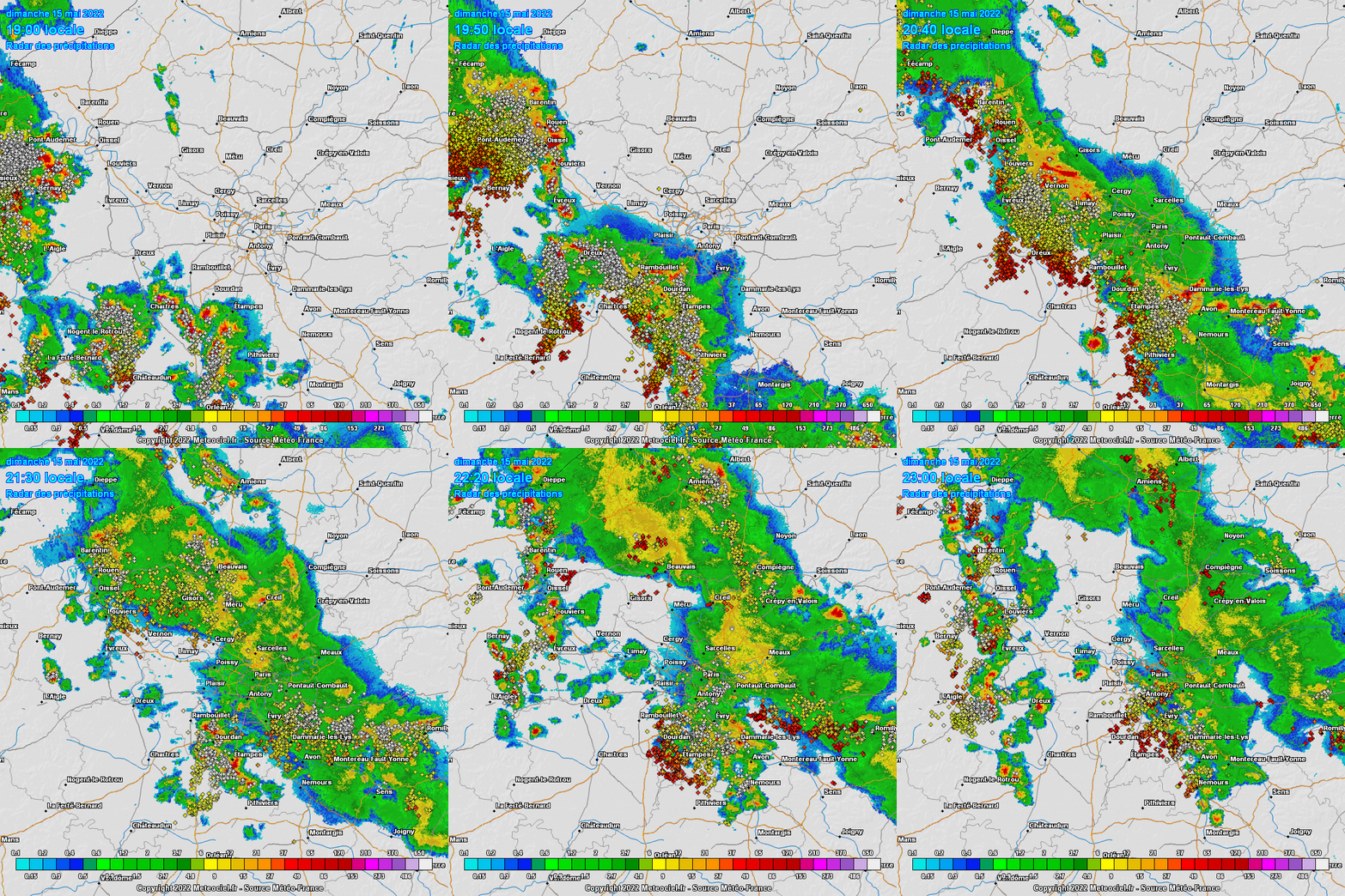
First bout of severe weather after temps failed to reach 30°C by a hair in Gay Paree. Of course the city was shunned by the brunt of it but still nice to get a few drops of rain as well as a window-shattering superbolt.  |
|
|
|
Post by rozenn on May 15, 2022 19:21:10 GMT -5
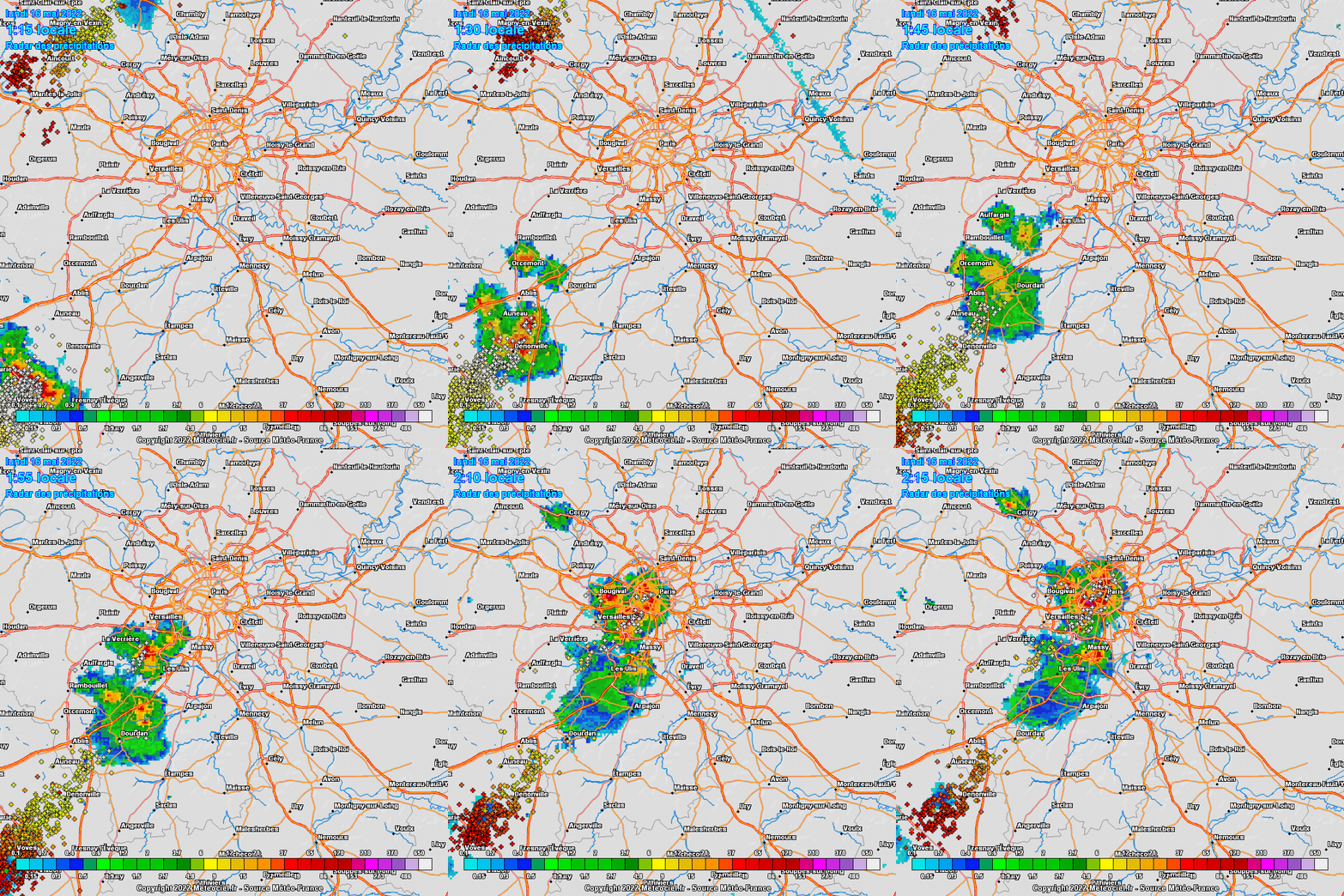
Noice. Just been woken up by this bad boy. Let's call it the dessert. EDIT: dammit that was an awe-inspiring bang. Just love this stuff. <3  |
|
|
|
Post by Beercules on May 15, 2022 20:05:56 GMT -5
|
|
|
|
Post by desiccatedi85 on May 15, 2022 20:10:35 GMT -5
Severe thunderstorms expected here tomorrow, with the storm prediction center highlighting a slight risk for my area on LI, and an enhanced risk just inland of here. Graphic and synopsis directly from the NWS SPC.  ...THERE IS AN ENHANCED RISK OF SEVERE THUNDERSTORMS FROM NORTHERN ...THERE IS AN ENHANCED RISK OF SEVERE THUNDERSTORMS FROM NORTHERN
VIRGINIA INTO NEW YORK...
...SUMMARY...
Scattered severe storms are expected Monday from central New
York/western New England southward into the Carolinas. Damaging
winds, hail, and few tornadoes will be possible through about 00Z.
...Synopsis...
A shortwave trough will move quickly from the OH Valley toward the
Mid Atlantic during the day, taking on a negative tilt across New
England after 00Z. Deep-layer wind fields will strengthen with this
trough, with substantial large-scale ascent from VA into NY.
A surface trough will deepen as it moves into eastern NY and PA,
with dewpoints holding near 60 F within the zone of convergence.
Farther south, the main cold front push will occur from MD into VA,
coincident with a midlevel dry slot. Here, dewpoints around 65 F
will be more common, with a plume of steep low-level lapse rates
emanating out of the southwest.
...Northeast and Mid Atlantic into the Carolinas...
Thunderstorms will likely be ongoing Monday morning from western PA
into WV along the developing cold front, and SBCIN will likely be
removed by 15Z due to cool 700 mb temperatures. Storms are expected
to become severe between 15-18Z as they develop into south-central
NY, central PA, and toward far northern VA. MLCAPE is expected to
average 1000-1500 J/kg, with effective deep-layer shear of 40-50 kt.
Mixed storm modes may occur, including supercells and QLCS. Damaging
wind gusts will be most likely. The tornado threat is expected to
increase during the late afternoon as the surface low/trough
deepens, low-level lapse rates are maximized, and effective SRH
increases to around 200 m2/s2. Cool temperatures aloft and elongated
hodographs will also favor sporadic hail in the stronger cells.
Although shear will be weaker farther south into the Carolinas,
strong heating and plentiful moisture will result in 2000 J/kg
MUCAPE with sufficient westerly shear to support multicells with
wind and hail threat. A few cells may linger toward 00-02Z. |
|
|
|
Post by ral31 on May 15, 2022 21:15:45 GMT -5
Tied or surpassed record highs multiple days this week. Hottest temp so far has been 95F. Then got strong storms yesterday evening after getting up to 94F. Saw the most hail I've seen in a while (around dime sized) and had a good bit of lightning. The storm formed developed and became severe-warned right over my location. The airport hardly got anything. Slightly cooler today with another chance of storms. Then back up to near record breaking temps in the mid-90's next week. You, my dude, live in an epic climate. Doesn't get better than that.
Here, after getting some good 80s and 90s and breaking some date records ourselves, the forecast goes south a bit after today - but at least it should still make it into the relatively seasonable lower 60s at worst. Would be better if we'd get storms like you did though.
I was lucky to get those storms. Much of the western half of Louisiana hasn't had anything in over a week with temps typical of mid-summer and likely won't get anything until next weekend. I was around the cutoff of storms that developed across eastern LA and MS. |
|
|
|
Post by rozenn on May 15, 2022 23:32:16 GMT -5
Amazing how a gay high latitude maritime climate like Gay Paree gets storms every second day    I wish. |
|
|
|
Post by Benfxmth on May 16, 2022 5:45:36 GMT -5
First 15 days of May at my PWS... Record high: 88.3°F (31.3°C) on the 3rd Average high: 76.6°F (24.8°C) Mean (max/min / 2): 68.9°F (20.5°C) Average low: 61.1°F (16.2°C) Record low: 50.9°F (10.5°C) on the 9th Average dew point: 61.5°F (16.4°C) Max. dew point: 75°F (24°C) for the 6th, 12:25-3:10 PM Min. dew point: 40°F (4°C) on the 9th, 10:54 PM Total precipitation: 1.34" (34.0 mm) No. precipitation days (>=0.01"): 6 No. precipitation days (>=0.04"): 4 No. precipitation days (>=0.1"): 3 No. precipitation days (>=0.4"): 1 Max. rainfall rate (instantaneous): 2.54"/hr (64.5 mm/hr) on the 7th, 5:23 PM Max. rainfall rate (10-min. avg.): 1.32"/hr (9.1 mm/hr) for the 7th, 5:20-5:30 PM Tied or surpassed record highs multiple days this week. Hottest temp so far has been 95F. Then got strong storms yesterday evening after getting up to 94F. Saw the most hail I've seen in a while (around dime sized) and had a good bit of lightning. The storm formed developed and became severe-warned right over my location. The airport hardly got anything. Slightly cooler today with another chance of storms. Then back up to near record breaking temps in the mid-90's next week. No >=90°F highs up here just yet (looks to be the latest first 90°F high since 2009 for me), but NWS, and weather models forecast highs exceeding that Thursday through Saturday as ridging builds back in, with a 94°F high forecast Friday (see cdweather.boards.net/post/215250 ). |
|
|
|
Post by rozenn on May 16, 2022 7:03:48 GMT -5
First bout of severe weather after temps failed to reach 30°C by a hair in Gay Paree. Didn't realize a lot of stations reached the 30°C mark: +31,3°C à Paris - Lariboisière +30,7°C à Paris - Luxembourg +30,2°C à Neuilly-sur-Marne - Ville-Evrard +30,5°C à Saint-Maur-des-Fossés +30,8°C à Suresnes +31,1°C à Nemours +30,9°C à Fontainebleau +30,8°C à Villemer +30,5°C à Vaux-sur-Lunain +30,4°C à La-Brosse-Montceaux +30,1°C à Crouy-sur-Ourcq +30,9°C à Saclas +30,3°C à Courdimanche +30,2°C à Brétigny-sur-Orge +30,2°C à Villemoisson-sur-Orge +30,6°C à Maule +30,4°C à Achères +30,3°C à Le Pecq |
|
|
|
Post by desiccatedi85 on May 16, 2022 14:13:51 GMT -5
Severe thunderstorm watch in effect today for most of Metro NYC including my county, Nassau, as storms roll in tonight.
|
|