|
|
Post by greysrigging on May 30, 2022 16:06:50 GMT -5
The last day of Autumn in Australia. May Cold Snap Challenging Records In NSW ( source: Weatherzone )  Some places in southern NSW may have just had their coldest May day on record. On Monday, a deep low pressure system dragged a mass of cold air and thick clouds across southeastern Australia. This combination of cold air, thick cloud and frequent rain severely limited the amount of daytime heating across a large area of southern and southeastern Australia during Monday's daylinght hours.  Some of the most abnormally low daytime temperatures occurred in southern NSW and the ACT, where maximums were around 8 to 10ºC below average for this time of year. Cooma Airport only reached a top of 4.1ºC on Monday. If this temperature is not exceeded by 9am on Tuesday, this will have been the airport’s coldest May day since records commenced in 1991. Bega’s maximum of 11.1ºC on Monday will also be a new May record if it isn’t exceeded by 9am on Tuesday, with data available back to 1965. Even Canberra may have just had one of its coldest May days in decades. If the city’s top temperature of 8.0ºC holds until 9am on Tuesday, then Monday will have been Canberra’s coldest May day since the famous cold snap in 2000. In addition to challenging temperature records, this week's cold snap is also expected to deliver some low-level snow across southeastern Australia in the coming days. |
|
|
|
Post by Ethereal on May 30, 2022 18:51:18 GMT -5
Freezing last day of autumn.   |
|
Deleted
Deleted Member
Posts: 0
|
Post by Deleted on May 31, 2022 3:40:55 GMT -5
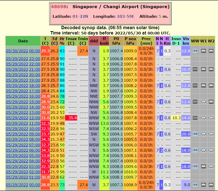
Intense heat in Singapore, with 35.4C recorded last Sunday at the airport. Tied the all-time record for May  |
|
|
|
Post by chesternz on May 31, 2022 6:03:15 GMT -5
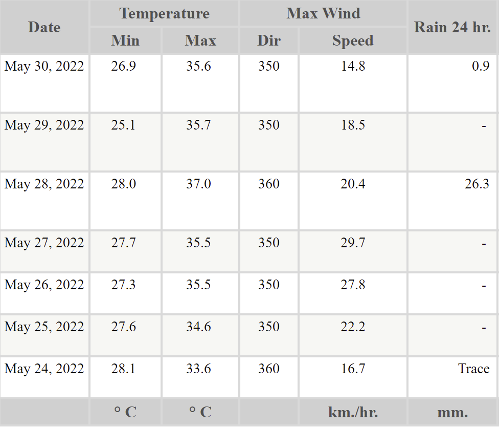
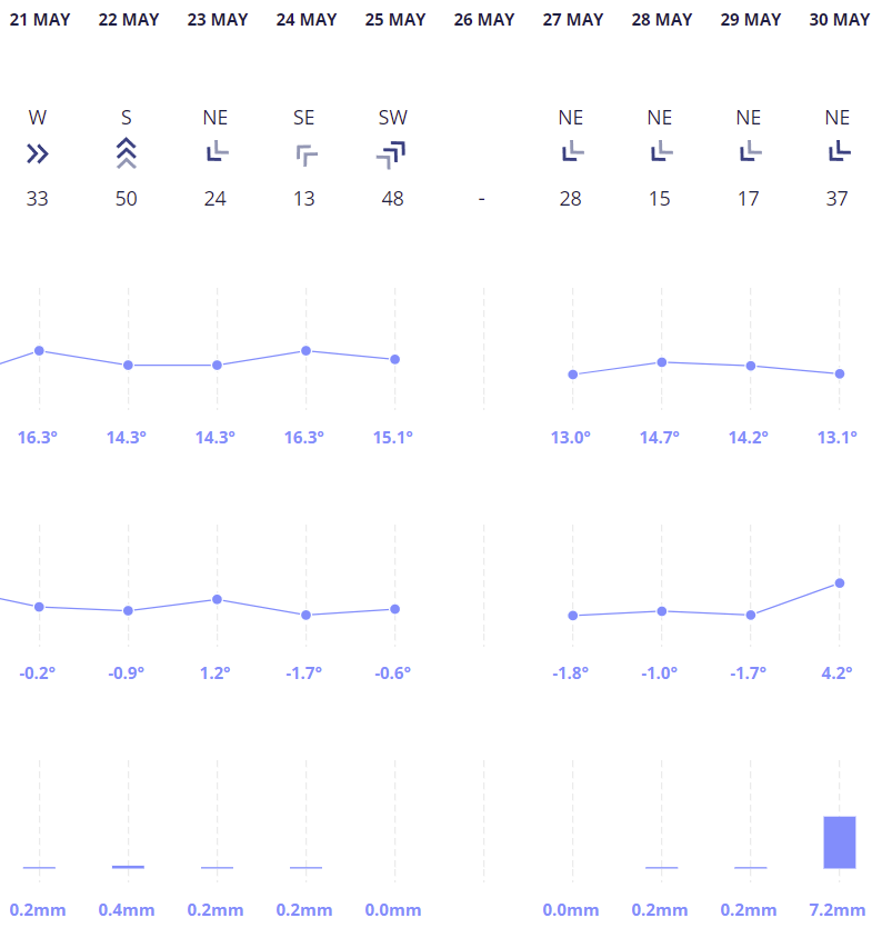
The past week is more or less how it's been the whole month. Sparse rainfall, hot nights, mix of cloud and sun and disappointingly few storms:  --- Meanwhile, back home in Christchurch they've had pretty consistent freezes. Data for one day is missing and they had one night slightly above freezing, but it's still a pretty impressive run and not even really winter yet:  |
|
|
|
Post by Babu on May 31, 2022 8:29:26 GMT -5
First >10'C low of the year last night with a low of 11.0'C at the airport and my PWS both. Still no 20'C at either of the stations though, which is uncommon, especially since May has been a little above average otherwise.
|
|
|
|
Post by nei on May 31, 2022 13:14:44 GMT -5
Brr
|
|
|
|
Post by greysrigging on May 31, 2022 16:55:49 GMT -5
Record breaking cold right accross the Pilbara for the last couple of days of Autumn. Departures from average of 17.2c in Marble Bar and 17.5c in Newman ! TELFER.  KARRATHA.  PARABURDOO.  NEWMAN.  ROEBOURNE.  MARBLE BAR.  |
|
|
|
Post by greysrigging on May 31, 2022 20:46:47 GMT -5
May rainfall AU. Certainly was an interesting May for large parts of Australia. Definitely consistent with a developing -IOD and the rain in WA and the persistent La Nina with the amount of blue in QLD. Now let's see what June has in store!  |
|
|
|
Post by Steelernation on Jun 1, 2022 2:06:52 GMT -5
Cool and rainy day to finish off May. High was only 64 (18 c) at around 10:30 AM and then it quickly cooled off when rain moved in. The whole afternoon was only on the low 50s (10-12 c).
0.48” (12 mm) has fallen so far, the highest amount since early in the month.
Down to 43 (6 c) now at 1 AM, chilly for June. Todays forecast high is only 56 (13 c), which would be the coolest June high since 2005.
|
|
|
|
Post by Cheeseman on Jun 1, 2022 6:11:59 GMT -5
greysrigging Yikes!! In the case of Newman, (in F) imagine having a high of 49 when the average high is 80...ridiculous! Here we ALMOST had our first 70 F (21 C) low - but it was 69 before midnight so that's what's going in my spreadsheet. I was expecting the cold front to come through before midnight, though, and fix yesterday's low in the 50s or lower 60s. I was also expecting storms to form along it, which of course never materialized. Now we've got a chilly but sunny day on tap that might not get warmer than the 69 it was at midnight...proof you always pay for any good weather you get around here.
|
|
|
|
Post by greysrigging on Jun 3, 2022 16:33:08 GMT -5
Australia's Third Warmest Autumn On Record Also Wettest In A Decade ( source: Weatherzone )  While parts of Australia are experiencing an unusually cold start to winter today, the country as a whole just registered its third warmest autumn on record. Australia’s average mean temperature between March and May was 23.44ºC, which is 1.44ºC above the 1961 to 1990 average. It is also the country’s third highest autumn mean temperature in records dating back to 1910, beaten only by 2005 (+1.78ºC) and 2016 (+1.98ºC).  It was also Australia’s wettest autumn in a decade, while NSW and the Murray Darling Basin had their 7th and 11th wettest autumn in 123 years of records, respectively. The NT had a notably warm and dry season, with the territory as a whole registering its 2nd warmest and 12th driest autumn on record. Autumn continued an exceptionally wet start to 2022 for large areas of eastern Australia, with parts of eastern NSW and southeast QLD registering their wettest January-to-May period on record. This included Sydney’s wettest and Brisbane’s 3rd wettest start to a year on record.  |
|
|
|
Post by strzelecki on Jun 3, 2022 18:26:52 GMT -5
Australia's Third Warmest Autumn On Record Also Wettest In A Decade ( source: Weatherzone )  While parts of Australia are experiencing an unusually cold start to winter today, the country as a whole just registered its third warmest autumn on record. Australia’s average mean temperature between March and May was 23.44ºC, which is 1.44ºC above the 1961 to 1990 average. It is also the country’s third highest autumn mean temperature in records dating back to 1910, beaten only by 2005 (+1.78ºC) and 2016 (+1.98ºC).  It was also Australia’s wettest autumn in a decade, while NSW and the Murray Darling Basin had their 7th and 11th wettest autumn in 123 years of records, respectively. The NT had a notably warm and dry season, with the territory as a whole registering its 2nd warmest and 12th driest autumn on record. Autumn continued an exceptionally wet start to 2022 for large areas of eastern Australia, with parts of eastern NSW and southeast QLD registering their wettest January-to-May period on record. This included Sydney’s wettest and Brisbane’s 3rd wettest start to a year on record.  I don't think this is a particularly clever showing from the BoM .. first of all the ‘ wet ‘ areas had cooler maximum temperatures, and secondly ‘ mean temperature ‘ is a stupid metric to use because it comprises the disrupted night-time cooling due to cloud. |
|
|
|
Post by Cheeseman on Jun 3, 2022 20:41:51 GMT -5
I don't think this is a particularly clever showing from the BoM .. first of all the ‘ wet ‘ areas had cooler maximum temperatures, and secondly ‘ mean temperature ‘ is a stupid metric to use because it comprises the disrupted night-time cooling due to cloud. Reminds me of my March this year. It was in fact warmer than average, but it sure didn't feel like it considering all the cloud and the fact it didn't get very warm. |
|
|
|
Post by strzelecki on Jun 4, 2022 0:55:57 GMT -5
Reminds me of my March this year. It was in fact warmer than average, but it sure didn't feel like it considering all the cloud and the fact it didn't get very warm. That's the opposite of what I said. The wet areas of AU were in fact BELOW average in maximum temperature. They were cooler, not simply felt cooler. |
|
|
|
Post by Cheeseman on Jun 4, 2022 6:14:19 GMT -5
Reminds me of my March this year. It was in fact warmer than average, but it sure didn't feel like it considering all the cloud and the fact it didn't get very warm. That's the opposite of what I said. The wet areas of AU were in fact BELOW average in maximum temperature. They were cooler, not simply felt cooler. Oh duh I'm stupid. My comment tied into the second part of yours though - the part about the flaws of using mean temperature as a cold cloudy day with a mild night could still turn out above average by mean. |
|