|
|
Post by greysrigging on Oct 21, 2022 2:34:10 GMT -5
I can't ever recall seeing the whole East Coast of Australia, from FNQ right around to SA looking like this in October. This is the La Nina event that just keeps on producing record breaking rains and floods.   |
|
|
|
Post by rozenn on Oct 21, 2022 3:27:01 GMT -5
Looking like the gap is for me.  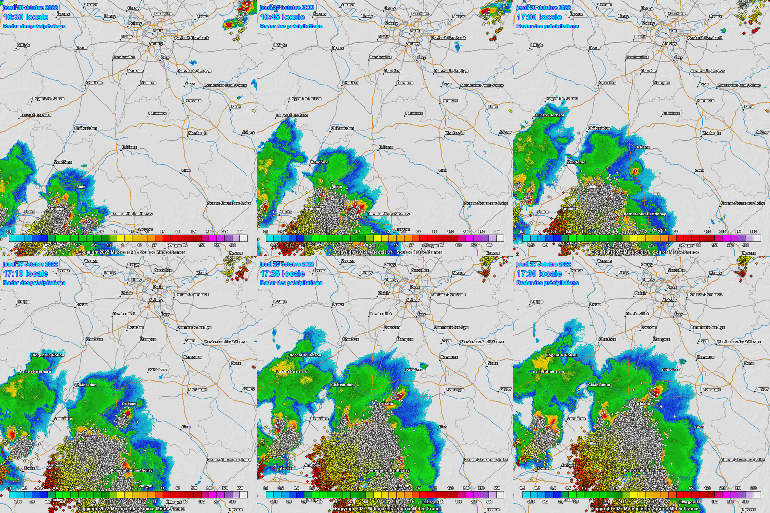 The big chunk was about 100 km east of my position, but I heard a few nice loud bangs yesterday evening, including one that made me jump while I was in a supermarket and shook all the walls. Another storm in the wee hours in the morning and again rn a bit further east in the suburbs. Orly is clocking a healthy 36 mm (1.4"). |
|
|
|
Post by Beercules on Oct 21, 2022 3:42:18 GMT -5
|
|
|
|
Post by greysrigging on Oct 21, 2022 4:28:52 GMT -5
C'mon now mate....you mob have had at least 3 days this month equal to or exceeding the monthly mean max temp.....  and ya mins are above average AND double the monthly rainfall....fucken hell...climatic paradise !  |
|
|
|
Post by jgtheone on Oct 21, 2022 4:31:06 GMT -5
|
|
|
|
Post by rozenn on Oct 21, 2022 13:03:58 GMT -5
That Renmark forecast is colder than mine.
|
|
|
|
Post by srfoskey on Oct 21, 2022 16:57:40 GMT -5
We had a low of 28°F (-2°C) this morning. That ties for the third earliest it's gotten this cold. It's now 88°F (31°C) with 17% relative humidity. We've warmed 60°F (33°C) in the past ~60 hours. This is probably one of the hottest temperatures we've had after a freeze in any fall ever. The latest we've gotten this hot is October 29, and most years don't get below freezing until November. |
|
|
|
Post by Steelernation on Oct 21, 2022 22:54:12 GMT -5
Yesterday was a stunning 81/31 at the coop station (27/-1 c), that’s a 50 f diurnal!
Biggest diurnal of the year, a couple of 46-47s but nothing this high. Not sure when the last 50 f diurnal was, not for several years probably.
Big change coming though, NWS says there’s a chance of snow Sunday night. Wont accumulate but still would be great to see some flurries. Next week will be below average with highs in the 50s and lows a bit below freezing.
|
|
|
|
Post by Met.Data on Oct 22, 2022 6:01:50 GMT -5
France is certainly getting some balmy late October weather this coming week.  |
|
|
|
Post by Babu on Oct 22, 2022 8:56:00 GMT -5
Apart from the last week the temp has been pretty much exactly the same ever since September started. Every single week has had roughly the same 8-10'C mean temp.  |
|
|
|
Post by srfoskey on Oct 23, 2022 0:52:56 GMT -5
We had a low of 28°F (-2°C) this morning. That ties for the third earliest it's gotten this cold. It's now 88°F (31°C) with 17% relative humidity. We've warmed 60°F (33°C) in the past ~60 hours. This is probably one of the hottest temperatures we've had after a freeze in any fall ever. The latest we've gotten this hot is October 29, and most years don't get below freezing until November. We got all the way up to 91°F (33°C) today. That's good for our fourth latest 90-degree high on record. Temperatures look to return to near to slightly below average next week. |
|
|
|
Post by Beercules on Oct 23, 2022 1:22:10 GMT -5
44mm rain at Renmark airport in half an hour, meanwhile here 7km east, nothing
|
|
|
|
Post by jgtheone on Oct 23, 2022 5:54:08 GMT -5
A truly historic day. 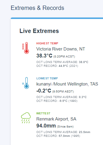 |
|
|
|
Post by Ariete on Oct 23, 2022 7:17:43 GMT -5
|
|
|
|
Post by rozenn on Oct 23, 2022 8:51:24 GMT -5
Strong storms by the looks of it in Normandy. Quite warm again. 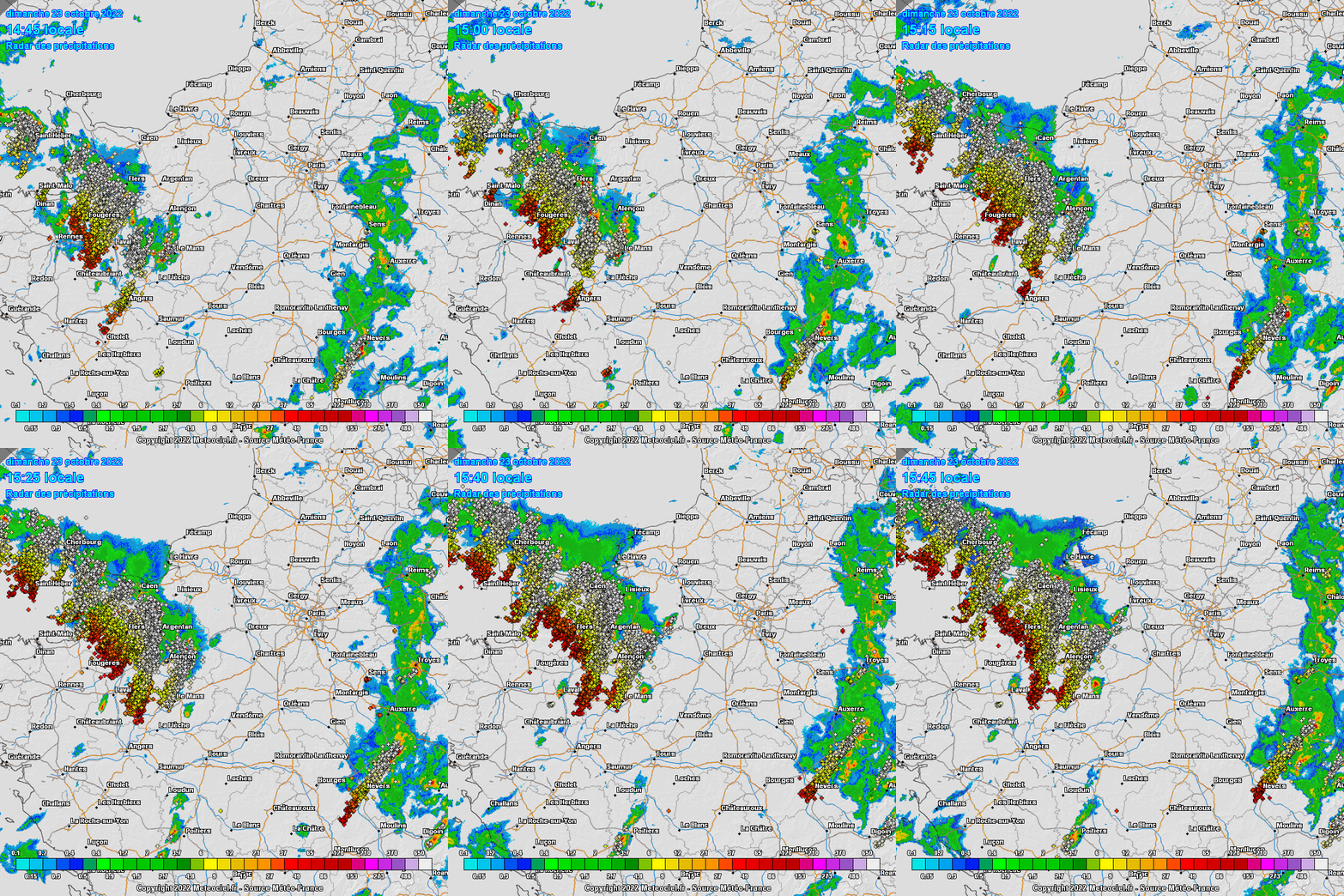 |
|
|
|
Post by rozenn on Oct 23, 2022 12:07:16 GMT -5
A small storm just darted through the SE suburbs. Could hear distant thunder from my position. 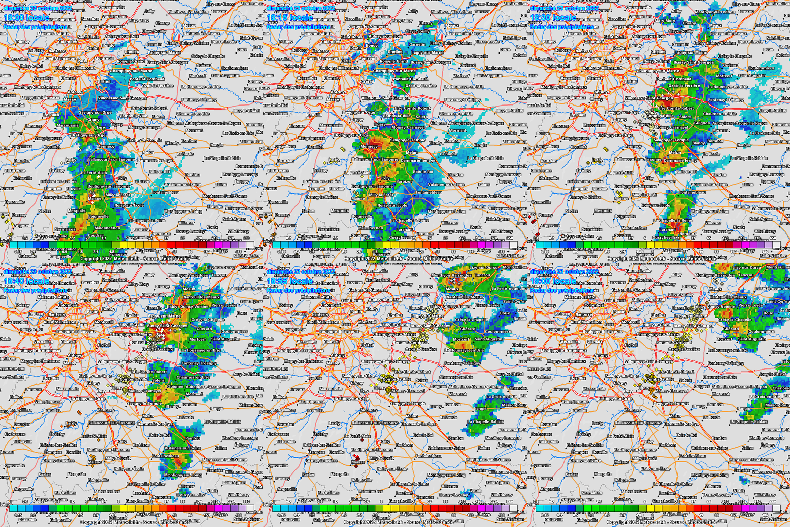 |
|
|
|
Post by greysrigging on Oct 23, 2022 21:51:41 GMT -5
Truly 'Renmarkable' SA Rainfall ( source: Weatherzone )  No, that's not a headline typo. There was a remarkable rain event in the SA Riverland town of Renmark (population 4600) on Sunday, so you'll excuse us if we call it "Renmarkable". Here's what happened. As a trough associated with a slow-moving low pressure system moved through the SA Riverland district, extremely heavy rain fell in a six-hour period between about 3:30 pm and 9:30 pm. Renmark recorded 95.6 mm in total in the 24 hours to 9 am Monday morning, with 92.6 mm falling in the six-hour period mentioned above. This made it the heaviest 24-hour rainfall in the town's recorded history, with records dating back to 1889. The old daily record was 88 mm on Jan 14, 2011. With 55.4 mm previously recorded in the gauge for October at Renmark, Sunday's downpour brought the monthly total to 151 mm, which makes this not just the wettest October on record, but the wettest month at any time of year. Flash flooding was reported in and around Renmark, however there is not yet flooding from the Murray River, which flows through town. #FLOOD Watch and Act MESSAGE issued for Renmark and Berri. If you are in this area you should prepare for flooding. Move valuables to a safe place. Consider going to a safer place if the path is clear. More info: t.co/RHRBjd60kJ ID:367/2 |
|
|
|
Post by rozenn on Oct 24, 2022 8:59:16 GMT -5
Current radar. Lol it's monsoon season in the SE suburbs. 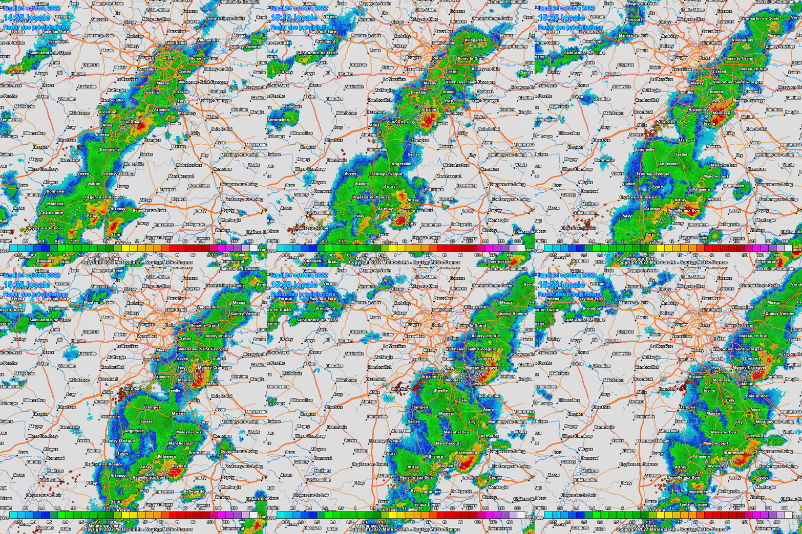 |
|
|
|
Post by jetshnl on Oct 24, 2022 17:07:04 GMT -5
|
|
|
|
Post by ral31 on Oct 24, 2022 21:02:10 GMT -5
Squall line in Texas right now with some warnings (I see a tornado warning for Jarrell, TX north of Austin). I'm guessing the line will weaken a bit as it reaches my area in the early morning hours. Hope we get enough rain to settle the dust somewhat (only had around a tenth of an inch of rain the past 6 weeks).
Got up to 87F today with dewpoint in the 60's and a strong southerly breeze.
|
|